Section 2. Class D Airspace Standards
17-2-1. CONFIGURATION
a. A Class D airspace area must be of sufficient size
to:
1. Allow for safe and efficient handling of operations.
2. Contain IFR arrival operations while between the
surface and 1,000 feet above the surface and IFR departure
operations while between the surface and the base of
adjacent controlled airspace.
b. Size and shape may vary to provide for 1 and 2 above.
The emphasis is that a Class D area must be sized to contain
the intended operations.
17-2-2. AIRPORT REFERENCE POINT/GEOGRAPHIC POSITION
a. The Class D airspace boundary should normally be
based on the airport reference point (ARP) or the geographic
position (GP) of the primary airport. The ARP/GP is the
center of the airport expressed in coordinates and should be
incorporated into the surface area's legal description.
b. If a Class E surface area is established in
conjunction with a part-time Class D area, the areas should
normally be coincident. Explain any differences in the
rulemaking documents.
NOTE-
Under certain conditions, the ARP/GP can change. If this
occurs, the airspace should be reviewed to ensure the
instrument procedures are still contained within existing
airspace.
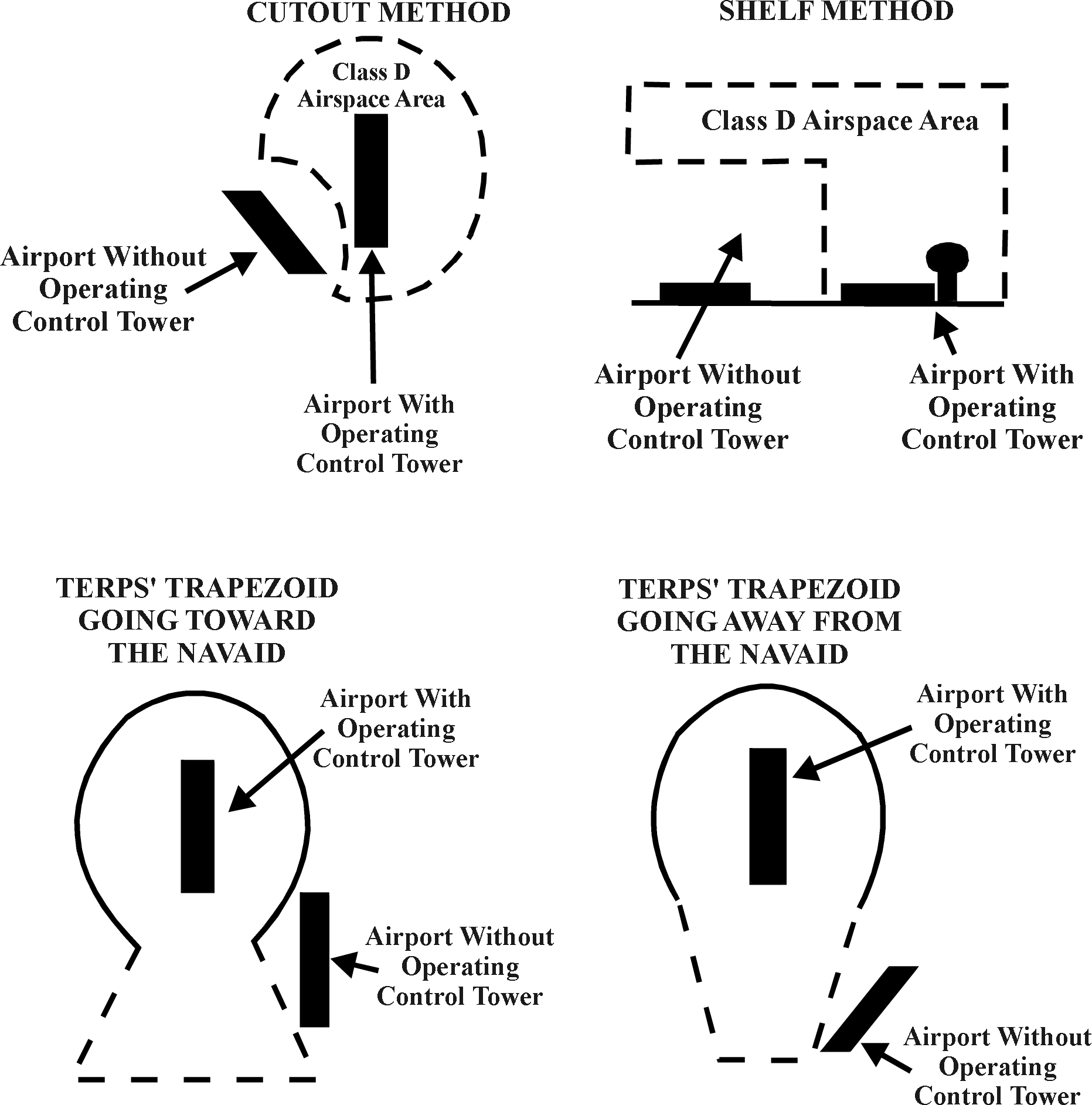
17-2-3. SATELLITE AIRPORTS
a. Using shelves and/or cutouts to the extent
practicable, exclude satellite airports from the Class D
airspace area (see FIG 17-2-3).
b. Satellite airports within arrival extensions may be
excluded using the actual dimensions of the TERPs trapezoid.
c. Do not exclude airports inside the TERPs primary
obstruction clearance area of the procedure(s) for which the
surface area is being constructed or when the exclusion
would adversely affect IFR operations.
17-2-4. ADJOINING CLASS D AIRSPACE AREAS
Designate separate Class D airspace area for airports in
proximity to each other. A common boundary line must be used
so that the airspace areas do not overlap. When
operationally advantageous, the common boundary separating
adjacent Class D areas may be eliminated if the areas are
contained in an existing Class B or Class C airspace area
controlled by the same IFR ATC facility.
17-2-5. DETERMINING CLASS D AREA SIZE
The
size of a Class D area, and any necessary extensions, is
determined by the use of a 200 feet per NM climb gradient
and information obtained from the person responsible for
developing instrument procedures (see
FIG 17-2-1).
NOTE-
Normally, the person responsible for developing instrument
procedures for civil and U.S. Army airports is a FAA
Aviation Standards Airspace Evaluation Specialist. A
military representative handles all other military
procedures.
17-2-6. DEPARTURES
a. When diverse departures are authorized, design the
Class D area using a radius of 3.5 NM plus the distance from
the ARP/GP to the departure end of the outermost runway (see
FIG 17-2-1).
b. When specific departure routes are required, the
routes will determine the shape of the Class D area. Use the
200 feet per NM climb gradient procedure in subparagraph a.
above and FIG 17-2-2 plus 1.8 NM
either side of the track(s) to be flown.
c. In areas with rising terrain, apply the procedures
reflected in FIG 17-2-2.
17-2-7. ARRIVAL EXTENSION
a. A Class D area arrival extension must be established
to the point where an IFR flight on an instrument approach
can be expected to descend to less than 1,000 feet above the
surface.
b. When multiple approach procedures are established
using the same initial approach course, but with different
1,000-foot points, the extension length must be based on the
approach requiring the greatest distance. Consistent with
safety and operational feasibility, if an adjustment to the
1,000-foot point can be made to eliminate or shorten an
extension, the specialist must coordinate with the person
responsible for developing the instrument approach to
request the adjustment.
c. The width of the extension must
be equal to the width of the TERPs primary obstruction
clearance area at the point where an IFR flight on an
instrument approach can be expected to descend to an
altitude below 1,000 feet above the surface. However, if the
primary area widens between the point where the flight
leaves 1,000 feet and the airport, the widened portion of
the primary area located outside the basic surface area
radius must be used for the extension. These extensions
must, in all cases, extend to a minimum of 1 NM on each side
of the centerline.
d. If all arrival extensions are 2 NM or less, they will
remain part of the basic Class D area. However, if any
extension is greater than 2 NM, then all extensions will be
Class E airspace.
17-2-8. VERTICAL LIMITS
Class
D areas should normally extend upward from the surface up to
and including 2,500 feet AGL. The altitude must be converted
to MSL and rounded to the nearest 100 feet. However, in a
low density or non-turbo aircraft traffic environment, a
vertical limit of 2,500 feet AGL may be excessive and a
lower altitude should be used.
NOTE-
The nearest 100 feet means that 49 feet and below must be
rounded down and 50 feet and above must be rounded up.
17-2-9. COMMUNICATIONS
Communications capability must exist with aircraft, that
normally operate within the Class D Surface Area down to the
runway surface of the primary airport (the airport upon
which the surface area is designated). This communication
may be either direct from the ATC facility having
jurisdiction over the area or by rapid relay through other
communications facilities which are acceptable to the ATC
facility having that jurisdiction.
17-2-10. WEATHER
OBSERVATIONS AND REPORTING
a. Weather observations must be taken at the primary
airport during the times and dates the Class D airspace is
active. A federally certified weather observer or a
federally commissioned automated weather observing system
(this includes all FAA and NWS approved and certified
weather reporting systems) can take the weather observation.
The weather observer must take routine (hourly) and special
observations. An automated weather observing system can
provide continuous weather observations.
b. Scheduled record and special observations from
weather observers or automated weather reporting systems
must be made available to the ATC facility(s) having control
jurisdiction over the Class D designated surface area. This
can be accomplished through Flight Service Station (FSS),
Longline Dissemination, National Weather Service (NWS), or
other FAA-approved sources. Facilities that require weather
reports from satellite airports may enter into a letter of
agreement (LOA) with the associated FSS, airline/contract
observer, airport management, etc.
NOTE-
1. At ATC sites where non-Federal employees
perform weather duties, the appropriate FAA office must
ensure that the reporting and dissemination requirements
applicable to National Weather Service and FAA publication
standards are followed.
2. In
facilities where direct access to automated weather
observing systems is not available, controllers will apply
the provisions of FAAO 7110.65, Air Traffic Control.
17-2-11. LOSS OF COMMUNICATION OR WEATHER REPORTING
CAPABILITY
a. If the capabilities outlined in paragraph
17-2-9 and/or paragraph
17-2-10 are temporarily out of
service for an active Class D Surface Area, a Notice to
Airmen must be issued stating the temporary loss of the
affected service.
b. However, if it is determined that the capabilities
are consistently unavailable, a Notice to Airmen must be
issued, as described above, and rulemaking action initiated
to revoke the Surface Area, as appropriate.
c. The FPT needs to be kept
informed of any planned action, especially when instrument
approach procedures (IAP) are involved, so as to assess the
impact on published approaches. The Standards Specialist may
decide changes are needed in the IAP, dependent on possible
new altimeter source and other considerations. These changes
will have an effect on the airspace action required; e.g.,
minimums may be raised, or procedure may be canceled.
FIG 17-2-1
CLASS D AREA RADIUS FORMULA
Class
D AREA RADIUS FORMULA
RADIUS
ARP/GP = AIRPORT REFERENCE POINT AND/OR GEOGRAPHIC POSITION
EOR = END OF OUTERMOST RUNWAY
6076 = ONE NAUTICAL MILE IN FEET
200 FEET PER NAUTICAL MILE = STANDARD CLIMB GRADIENT
D = DISTANCE IN FEET FROM ARP/GP TO EOR 3.5 MILES = DISTANCE
REQUIRED FOR DEPARTURE TO REACH 700-FOOT CLASS E AIRSPACE
USING STANDARD CLIMB GRADIENT
(700/200)
2.5 MILES = DISTANCE REQUIRED FOR DEPARTURE TO REACH
1200-FOOT
CLASS E AIRSPACE USING STANDARD CLIMB GRADIENT
((1200 - 700)/200)
THE FORMULA CAN BE EXPRESSED AS: R = D/6076 + 3.5
Example:
At
Airport A, the distance from the geographic position to the
end of the outermost runway
is 4,023 feet; therefore, assuming flat terrain, the radius
is calculated as:
R =
4023/6076 + 3.5 = .662 + 3.5 = 4.162 = 4.2
The radius for the 700-foot Class E airspace becomes: 4.2 +
2.5 = 6.7
RISING TERRAIN
In the
above example, an aircraft departing to the west would reach
the lateral boundary of the surface area without reaching
700 feet AGL and, in effect, leave controlled airspace. To
ensure that the lateral boundary of the Class D area is
congruent with the beginning of the 700-foot Class E
airspace, the specialist must:
a. Search
the Class D area's radius circle for the highest terrain.
b. Calculate the MSL height of the aircraft by adding
700 feet to the airport elevation.
c. Compare
MSL altitudes of the aircraft versus the highest terrain to
determine if the
aircraft has reached the overlying or adjacent controlled
airspace. If not, increase the size
of the Class D area, as necessary, to contain the departure.
NOTE-
When terrain, obstacles, or procedures prohibit departures
in portions of the basic surface area, a terrain search is
not necessary in that area and that height is not used in
the computations.
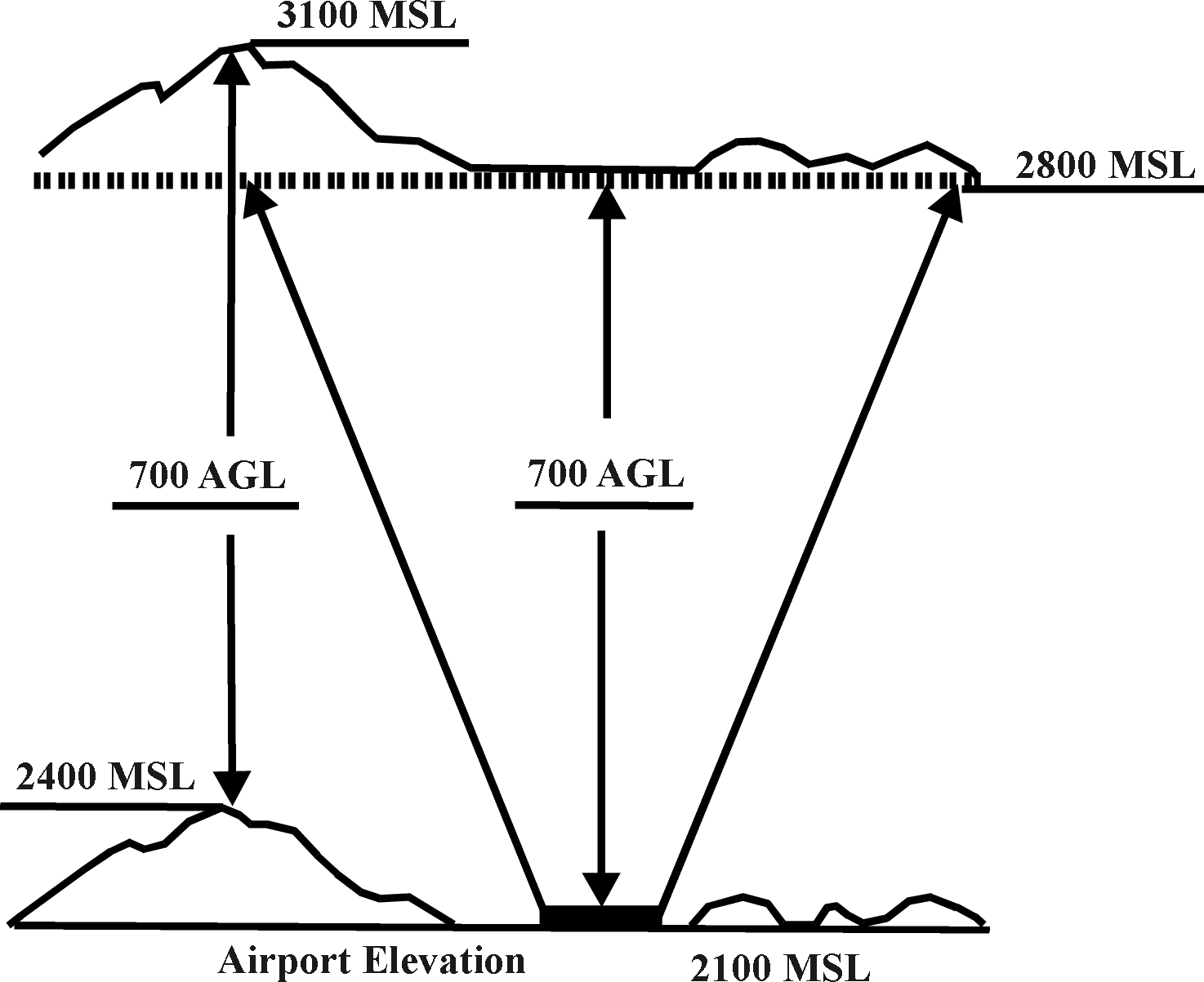
FIG 17-2-3
EXAMPLES OF SATELLITE AIRPORTS EXCLUDED FROM SURFACE AREA
AIRSPACE AREAS
|