|
Table of Contents
|
Paragraph
Number
|
Title
|
Page
|
|
2-1-10
|
NAVAID MALFUNCTIONS
|
BG3
|
|
2-1-14
|
COORDINATE USE OF AIRSPACE
|
BG4
|
|
2-7-2
|
ALTIMETER SETTING ISSUANCE BELOW
|
BG5
|
|
2-9-3
|
CONTENT
|
BG5
|
|
3-9-8
|
INTERSECTING RUNWAY SEPARATION
|
BG6
|
|
3-9-9
|
NONINTERSECTING CONVERGNING RUNWAY
|
BG6
|
|
4-8-1
|
APPROACH CLEARANCE
|
BG11
|
|
5-4-5
|
TRANSFERRING CONTROLLER HANDOFF
|
BG13
|
|
5-4-6
|
RECEIVING CONTROLLER HANDOFF
|
BG14
|
|
5-9-4
|
ARRIVAL INSTRUCTIONS
|
BG15
|
|
7-5-3
|
SEPARATION
|
BG17
|
|
7-9-4
|
SEPARATION
|
BG19
|
|
8-1-9
|
RVSM OPERATIONS
|
BG20
|
|
10-3-1
|
OVERDUE AIRCRAFT
|
BG21
|
|
10-3-2
|
INFORMATION TO BE FORWARDED TO ARTCC
|
BG21
|
|
10-3-3
|
INFORMATION TO BE FORWARDED TO RCC
|
BG21
|
|
10-3-4
|
ALNOT
|
BG21
|
|
10-3-6
|
Aircraft position plots
|
BG21
|
|
10-3-7
|
ALNOT CANCELLATION
|
BG21
|
1. PARAGRAPH NUMBER AND TITLE: 2110. NAVAID MALFUNCTIONS
2. BACKGROUND: On July 31, 2013, revised approach clearance procedures, as specified in FAA Order
JO 7110.65, 481, were disseminated to all Terminal and En Route ATC facilities. Those procedures did not
include GPS Testing NOTAMs, changes to GPS anomaly reporting, or account for WAAS. This resulted in a
necessary change to accompany paragraph 2110.
3. CHANGE:
|
OLD
|
|
NEW
|
|
2110. NAVAID MALFUNCTIONS
|
|
2110. NAVAID MALFUNCTIONS
|
|
Title through a5
|
|
No Change
|
|
b. When an aircraft reports a GPS anomaly,
request the following information and/or take the
following actions:
|
|
b. When an aircraft reports a GPS or WAAS
anomaly, request the following information and/or
take the following actions:
|
|
1. Record the following minimum information:
|
|
1. Record the following minimum information:
|
|
(a) Aircraft call sign and type.
|
|
(a) Aircraft make, model, and call sign.
|
|
(b) Location.
|
|
(b) Location or position, and altitude at the
time where GPS or WAAS anomaly was
observed.
|
|
(c) Altitude.
|
|
Delete
|
|
(d) Date/time of occurrence.
|
|
(c) Date/time of occurrence.
|
|
Add
|
|
2. Request a report from a second aircraft.
|
|
2. Record the incident on FAA Form 7230-4 or
appropriate military form.
|
|
3. Record the incident on FAA Form 7230-4 or
appropriate military form.
|
|
3. Broadcast the anomaly report to other aircraft
as necessary.
|
|
4. Inform other aircraft of the anomaly as
specified in paragraph 481j or k, as applicable.
|
|
PHRASEOLOGY-
ATTENTION ALL AIRCRAFT, GPS REPORTED
UNRELIABLE IN VICINITY/AREA (position).
|
|
PHRASEOLOGY-
ATTENTION ALL AIRCRAFT, GPS REPORTED
UNRELIABLE (OR WAAS UNAVAILABLE) IN
VICINITY/AREA (position).
|
|
EXAMPLE-
“Attention all aircraft, GPS reported unreliable in the
area 30 miles south of Waco VOR.”
|
|
EXAMPLE-
“Attention all aircraft, GPS reported unreliable (or
WAAS unavailable) in the area 30 miles south of Waco
VOR.”
|
|
c. When an aircraft reports a Wide Area
Augmentation System (WAAS) anomaly, request
the following information and/or take the following
actions:
|
|
c. When a pilot reports a WAAS anomaly,
determine from the pilot what indications he or
she observes and record the information in
accordance with subparagraph b above.
|
|
1. Determine if the pilot has lost all WAAS
service.
|
|
Delete
|
|
PHRASEOLOGY-
ARE YOU RECEIVING ANY WAAS SERVICE?
|
|
Delete
|
|
2. If the pilot reports receipt of any WAAS
service, acknowledge the report and continue
normal operations.
|
|
Delete
|
|
3. If the pilot reports loss of all WAAS service,
report as a GPS anomaly using procedures in
subpara 2-1-10b.
|
|
Delete
|
1. PARAGRAPH NUMBER AND TITLE: 2114. COORDINATE USE OF AIRSPACE
2. BACKGROUND: A Corrective Action Request (CAR) was issued in March 2010 identifying issues
concerning confusion regarding responsibility for point out coordination. Conflicting language was identified
between this paragraph and Paragraphs 545, Transferring Controller Handoff, and 546, Receiving Controller
Handoff. This change, along with amendments to paragraphs 545 and 546, is intended to identify which
controller(s) has coordination responsibility.
3. CHANGE:
|
OLD
|
|
NEW
|
|
2114. COORDINATE USE OF AIRSPACE
|
|
2114. COORDINATE USE OF AIRSPACE
|
|
Title through a
|
|
No Change
|
|
b. Before you issue control instructions directly or
relay through another source to an aircraft which is
within another controller's area of jurisdiction that
will change that aircraft's heading, route, speed, or
altitude, ensure that coordination has been
accomplished with each of the controllers listed
below whose area of jurisdiction is affected by
those instructions unless otherwise specified by a
letter of agreement or a facility directive:
|
|
b. Before you issue a control instruction
directly to a pilot that will change the aircraft’s
heading, route, speed, or altitude, you must
ensure that coordination has been completed
with all controllers whose area of jurisdiction is
affected by those instructions unless otherwise
specified by a letter of agreement or facility
directive. If your control instruction will be
relayed to the pilot through a source other than
another radar controller (FSS, ARINC, another
pilot, etc.), you are still responsible to ensure that
all required coordination is completed.
|
|
1. The controller within whose area of
jurisdiction the control instructions will be issued.
|
|
Delete
|
|
2. The controller receiving the transfer of
control.
|
|
Delete
|
|
3. Any intervening controller(s) through whose
area of jurisdiction the aircraft will pass.
|
|
Delete
|
|
c. If you issue control instructions to an aircraft
through a source other than another controller (e.g.,
ARINC, FSS, another pilot) ensure that the
necessary coordination has been accomplished with
any controllers listed in subparas b1, 2, and 3,
whose area of jurisdiction is affected by those
instructions unless otherwise specified by a letter of
agreement or a facility directive.
|
|
Delete
|
|
Add
|
|
NOTE-
1. It is good operating practice for controllers to
confirm that required coordination has been/will be
effected, especially in unusual circumstances, such as
recently modified sector configurations, airspace
changes, route changes, etc.
2. Ensuring that all required coordination has been
completed does not necessarily imply that the controller
issuing the control instruction directly to the pilot has
to perform the coordination action.
|
1. PARAGRAPH NUMBER AND TITLE: 272. ALTIMETER SETTING ISSUANCE BELOW
LOWEST USABLE FL
2. BACKGROUND: An inquiry was received regarding the currency of CFR Exemption 2861A, Single
Altimeter Setting for Frequent Transit of FL180, to 14 CFR 91.121, Altimeter Settings. Research validates that
Exemption 2861A is still current and active. The exemption requires an LOA between the affected FAA ATC
facilities and DOD that authorizes certain DOD aircraft the option of using a “single altimeter setting" while
operating within restricted areas, MOAs, and ATC assigned airspace. This exemption originally referred to
14 CFR 91.81, Altimeter Settings, but now applies to 14 CFR 91.121, Altimeter Settings. There is no change in
CFR language or ATC procedures with this DCP.
3. CHANGE:
|
OLD
|
|
NEW
|
|
272. ALTIMETER SETTING ISSUANCE
BELOW LOWEST USABLE FL
|
|
272. ALTIMETER SETTING ISSUANCE
BELOW LOWEST USABLE FL
|
|
Title through e
|
|
No Change
|
|
f. Department of Defense (DOD) aircraft which
operate on “single altimeter settings” (CFR
Exemption 2861A) must be issued altimeter
settings in accordance with standard procedures
while the aircraft are en route to and from their
restricted areas, MOAs, and ATC assigned airspace
areas.
|
|
f. Department of Defense (DOD) aircraft that are
authorized to operate in restricted areas, MOAs,
and ATC assigned airspace areas on “single
altimeter settings” (CFR Exemption 2861A), must
be issued altimeter settings in accordance with
standard procedures while the aircraft are en route
to and from the restricted areas, MOAs, and ATC
assigned airspace areas.
|
|
Add
|
|
NOTE-
The DOD is responsible for conducting all “single
altimeter setting” operations within the boundaries of
MOAs, restricted areas, and ATCAAs. Under an LOA,
the DOD provides safe altitude clearance between DOD
aircraft and other aircraft operating within, above, and
below the MOAs, restricted areas, and ATCAAs with
appropriate clearance of terrain.
|
|
Add
|
|
REFERENCE-
FAAO JO 7610.4, Appendix 20, Grant of Exemption No. 2861A
Single Altimeter Setting For Frequent Transit of FL180.
|
1. PARAGRAPH NUMBER AND TITLE: 293. CONTENT
2. BACKGROUND: On September 5, 2013, the final report of the Performancebased Operations Aviation
Rulemaking Committee (PARC)/Commercial Aviation Safety Team (CAST) identified several issues pertaining
to the operational use of flight path management systems. This change is an effort to address the safety issues
identified in the report. These include: the increased risk of Controlled Flight Into Terrain (CFIT) when flying
conventional nonprecision approaches; pilot abilities and increased systems management; and the
recommendation that ATC begin to transition away from conventional procedures constructed upon
groundbased navigation aids to increased use of RNAVbased navigation.
3. CHANGE:
|
OLD
|
|
NEW
|
|
293. CONTENT
|
|
293. CONTENT
|
|
Title through d EXAMPLE
|
|
No Change
|
|
e. Instrument/visual approach/s in use. Specify
landing runway/s unless the runway is that to which
the instrument approach is made.
|
|
e. Instrument/visual approach/es in use. Specify
landing runway/s unless the runway is that to which
the instrument approach is made. Before
advertising nonprecision approaches, priority
should be given to available precision, then APV
approaches.
|
1. PARAGRAPH NUMBER AND TITLE:
398. INTERSECTING RUNWAY SEPARATION, and
399. NONINTERSECTING CONVERGING RUNWAY OPERATIONS
2. BACKGROUND: A Corrective Action Request was developed identifying airports where aircraft
operating on nonintersecting converging runways were passing through the airborne intersection on the extended
centerline of the runway within 14 seconds of each other. Additionally, on July 1, 2013, the National
Transportation Safety Board issued Safety Recommendation A13024 identifying the same issue. The ATO
tasked Air Traffic Managers at those facilities that have nonintersecting converging runways where the extended
centerline of a runway crosses a converging runway or the extended centerline of a converging runway within 1
NM of either departure end to convene/complete a safety risk management panel to review these operations. The
changes were created by a workgroup at the direction of the Office of Safety and Technical Training (AJI). The
changes were incorporated via a notice. The notice was implemented at LAS, CLT, JFK, IAD, IAH, ORD, and
BOS beginning January 15, 2014. Secondly, the change was implemented at DFW, MSP, DEN, BWI, HNL,
MEM, MIA, PHL, SLC, and TPA beginning April 2, 2014. Lastly, the change was implemented at all additional
affected airports beginning July 9, 2014.
3. CHANGE:
|
OLD
|
|
NEW
|
|
398. INTERSECTING RUNWAY
SEPARATION
|
|
398. INTERSECTING RUNWAY
OPERATIONS
|
|
Title through a
|
|
No Change
|
|
b. Separate departing aircraft from an aircraft
using an intersecting runway, or nonintersecting
runways when the flight paths intersect, by ensuring
that the departure does not begin takeoff roll until
one of the following exists:
|
|
b. Separate departing aircraft from another
aircraft using an intersecting runway by ensuring
that the departure does not begin takeoff roll until
one of the following exists:
|
|
REFERENCE-
FAAO JO 7110.65, Para 2121, Traffic Advisories.
|
|
No Change
|
|
1. The preceding aircraft has departed and
passed the intersection, has crossed the departure
runway, or is turning to avert any conflict.
(See FIG 395 and FIG 396).
|
|
1. The preceding aircraft has departed and
passed the intersection or is turning to avert any
conflict. (See FIG 395).
|
|
FIG 395
Intersecting Runway Separation
|
|
No Change
|
|
FIG 396
Intersecting Runway Separation
|
|
Delete
|
|
2. A preceding arriving aircraft is clear of the
landing runway, completed the landing roll and will
hold short of the intersection, passed the
intersection, or has crossed over the departure
runway. (See FIG 397 and FIG 398).
|
|
2. A preceding arriving aircraft is clear of the
landing runway, completed the landing roll and will
hold short of the intersection, or has passed the
intersection. (See FIG 396).
|
|
REFERENCE-
P/CG Term – Clear of Runway
|
|
No Change
|
|
FIG 397
Intersecting Runway Separation
|
|
FIG 396
Intersecting Runway Separation
|
|
FIG 3-9-8
|
|
Delete
|
|
WAKE TURBULENCE APPLICATION
through b3 note
|
|
No Change
|
|
(a) Crossing runways if projected flight paths
will cross. (See FIG 3-9-9).
|
|
(a) Intersecting runways if projected flight
paths will cross. (See FIG 3-9-7).
|
|
FIG 3-9-9
Crossing Runways
|
|
FIG 397
Intersecting Runways
|
|
(b) A parallel runway separated by 2,500 feet
or more if projected flight paths will cross. (See
FIG3910).
|
|
(b) A parallel runway separated by 2,500 feet
or more if projected flight paths will cross. (See
FIG398).
|
|
FIG 3910
Parallel Runway
|
|
FIG 398
Parallel Runway
|
|
4. Separate IFR/VFR aircraft departing behind a
landing heavy jet/B757 on a crossing runway if the
departure will fly through the airborne path of the
arrival 2 minutes. (See FIG 3-9-11).
|
|
4. Separate IFR/VFR aircraft departing behind a
landing heavy jet/B757 on an intersecting runway
if the departure will fly through the airborne path of
the arrival 2 minutes. (See FIG 3-9-9).
|
|
FIG 3911
Departure on Crossing Runway
|
|
FIG 399
Departure on Intersecting Runway
|
|
OLD
|
|
NEW
|
|
Add
|
|
399. NONINTERSECTING CONVERGING
RUNWAY OPERATIONS
|
|
Add
|
|
a. Separate departing aircraft from an aircraft
using a nonintersecting runway when the flight
paths intersect by ensuring that the departure
does not begin takeoff roll until one of the
following exists:
|
|
Add
|
|
REFERENCE-
FAAO JO 7110.65, Para 2-1-21, Traffic Advisories.
|
|
Add
|
|
1. The preceding aircraft has departed and
crossed the departure runway, or is turning to
avert any conflict. (See FIG 3-9-10).
|
Add
FIG 3910
Intersecting Runway Separation
|
Add
|
|
2. A preceding arriving aircraft has completed
the landing roll and will hold short of the projected
intersection, passed the projected intersection, or
has crossed over the departure runway (See FIG
3-9-11 and FIG 3912).
|
Add
FIG 3911
Intersecting Runway Separation
Add
FIG 3912
Intersecting Runway Separation
Add
|
WAKE TURBULENCE APPLICATION
|
|
Add
|
|
b. Separate IFR/VFR aircraft taking off behind a
heavy jet/B757 departure by 2 minutes when
departing a crossing runway if projected flight paths
will cross. (See FIG 3-9-13).
|
Add
FIG 3913
Intersecting Runway Separation
|
Add
|
|
NOTE-
Takeoff clearance to the following aircraft should not be
issued until 2 minutes after the heavy jet/B757 begins
takeoff roll.
|
|
Add
|
|
c. Separate IFR/VFR aircraft departing behind a
landing heavy jet/B757 on a crossing runway if the
departure will fly through the airborne path of the
arrival 2 minutes. (See FIG 3-9-14).
|
Add
FIG 3914
Intersecting Runway Separation
|
Add
|
|
d. Air traffic controllers must not approve pilot
requests to deviate from the required wake
turbulence time interval if the preceding aircraft is
a heavy jet/B757.
|
|
Add
|
|
REFERENCE-
FAAO JO 7110.65, Para 583, Successive or Simultaneous
Departures.
FAAO JO 7110.65, Para 585, Departures and Arrivals on Parallel or
Nonintersecting Diverging Runways.
|
|
Add
|
|
e. If the extended centerline of a runway crosses
a converging runway or the extended centerline of
a converging runway within 1 NM of either
departure end, apply the provisions of Paragraph
398, Intersecting Runway Separation. (See FIG
3915).
|
|
Add
|
|
REFERENCE-
FAAO JO 7210.3, Para 10314, GoAround/Missed Approach.
|
Add
FIG 3915
Intersecting Runway Separation
Add
FIG 3916
Intersecting Runway Separation
|
Paragraph 399 and 3910
|
|
Renumber to 3910 and 3911
|
1. PARAGRAPH NUMBER AND TITLE: 481. APPROACH CLEARANCE
2. BACKGROUND: Since the implementation of the revised paragraph 481, industry stakeholders and the
agency resolved concerns stemming from language incorporated into the original 481 change concerning
Radius to Fix (RF) legs. These concerns have been resolved, and have resulted in some changes to AFS
assumptions for conducting RNAV approaches with RF legs. This negates the need to retain the leg length
procedures for RNP approaches with RF legs. Additionally, there have been changes coordinated between ATO
and AFS concerning new GPS testing NOTAMs and GPS anomaly procedures to articulate a change in the
structure of these NOTAMS from using “unreliable” to “may not be available.”
3. CHANGE:
|
OLD
|
|
NEW
|
|
481. APPROACH CLEARANCE
|
|
481. APPROACH CLEARANCE
|
|
Title through c
|
|
No Change
|
|
d. For RNAVequipped aircraft operating on
unpublished routes, issue approach clearance for
conventional or RNAV SIAP only after the aircraft
is: (See FIG 482).
|
|
d. For RNAVequipped aircraft operating on
unpublished routes, issue approach clearance for
conventional or RNAV SIAP including
approaches with RF legs only after the aircraft is:
(See FIG 482).
|
|
1. Established on a heading or course direct to
the IAF at an intercept angle not greater than 90
degrees and is assigned an altitude in accordance
with b2. Radar monitoring is required until the
aircraft is established on a segment of the
instrument approach procedure for RNAV (RNP)
approaches when no procedure turn or holdinlieu
of procedure turn will be executed.
|
|
1. Established on a heading or course direct to
the IAF at an intercept angle not greater than 90
degrees and is assigned an altitude in accordance
with b2. Radar monitoring is required to the IAF
for RNAV (RNP) approaches when no holdinlieu
of procedure turn is executed.
|
|
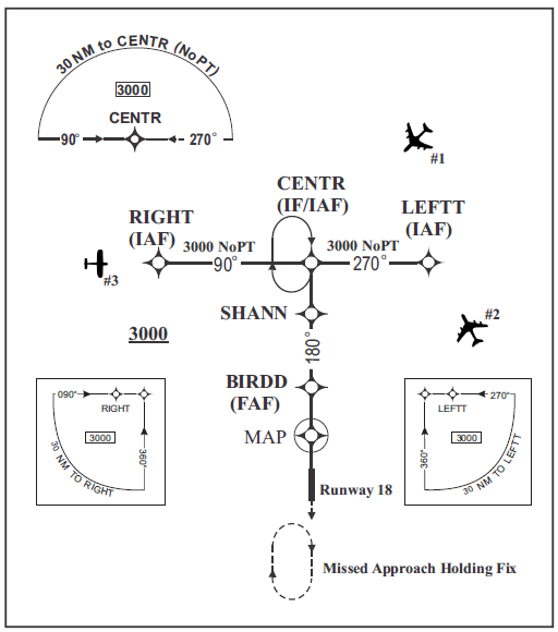
EXAMPLE-
Aircraft 1 can be cleared direct to CENTR. The intercept
angle at that IAF is 90 degrees or less. The minimum
altitude for IFR operations (14 CFR, section 91.177)
along the flight path to the IAF is 3,000 feet. If a hold in
lieu of procedure turn pattern is depicted at an IAF and
a TAA is not defined, the aircraft must be instructed to
conduct a straightin approach if ATC does not want the
pilot to execute a holdinlieu procedure turn. “Cleared
direct CENTR, maintain at or above three thousand until
CENTR, cleared straightin RNAV Runway One Eight
Approach.”
|
|
No Change
|
|
d2 through f1
|
|
No Change
|
|
2. On a heading or course direct to the IAF when
a holdinlieu of procedure turn is published and the
pilot will execute the procedure, or
|
|
2. In accordance with paragraph d.
|
|
3. On a heading or course direct to the IAF/IF, at
intercept angles no greater than 90 degrees and the
distance to the waypoint beginning the RF leg is
6NM or greater, or
|
|
3. Do not clear aircraft direct to any waypoint
beginning or within an RF leg.
|
|
4. With radar monitoring, on a heading or course
direct to any waypoint 3 miles or more from the
waypoint that begins the RF leg, at an intercept
angle no greater than 30 degrees. (See FIG 484.)
|
|
4. Do not assign fix/waypoint crossing speeds
in excess of charted speed restrictions.
|
|
5. Do not clear aircraft direct to any waypoint
beginning or within an RF leg.
|
|
Delete
|
|
NOTE 1 through Fig 484 NOTE 2
|
|
No Change
|
|
EXAMPLE-
Aircraft 1 can be cleared to SCOND because the distance
to THIRD, where the RF leg begins is 3NM or greater and
the intercept angle will be 30 degrees or less and is radar
monitored.
Aircraft 2 can be cleared direct to FIRST because the
intercept angle is 90 degrees or less and the distance from
FIRST to THIRD is 6NM or greater.
|
|
Delete
|
|
g through FIG485
|
|
No Change
|
|
j. For GPS UNRELIABLE NOTAMs, inform
pilots requesting a GPS or RNAV approach that
GPS is unreliable and clear the aircraft for the
approach. This advisory may be omitted if
contained in the Automatic Terminal Information
Service (ATIS) broadcast.
|
|
j. When GPS TESTING NOTAMs are
published and testing is actually occurring,
inform pilots requesting or cleared for a RNAV
approach that GPS may not be available and
request intentions. Do not resume RNAV
approach operations until certain that GPS
interference is no longer a factor or such GPS
testing exercise has ceased.
|
|
k. For pilot reported GPS anomalies, advise
subsequent aircraft requesting a GPS or RNAV
approach that GPS is unreliable and clear the
aircraft for the approach. This advisory may be
discontinued after 15 minutes if no subsequent
reports are received.
|
|
k. During times when pilots report GPS
anomalies, request the pilot's intentions and/or
clear that aircraft for an alternative approach, if
available and operational. Announce to other
aircraft requesting an RNAV approach that GPS
is reported unavailable and request intentions.
|
|
REFERENCE-
FAAO JO 7110.65, Para 2110, NAVAID Malfunctions
FAAO JO 7110.65, Para 4712, Airport Conditions
|
|
No Change
|
|
PHRASEOLOGY-
CLEARED (approach), GPS UNRELIABLE.
|
|
Delete
|
|
l. For Wide Area Augmentation System
(WAAS) UNAVAILABLE NOTAMs, advise
aircraft requesting a GPS or RNAV approach that
WAAS is unavailable and clear the aircraft for the
approach. This advisory may be omitted if
contained in the ATIS broadcast.
|
|
l. When clearing an aircraft for an RNAV
approach, and a GPS NOTAM is published (a
WAAS NOTAM is not issued), both GPS and
WAAS may become unavailable. Therefore,
when a GPS anomaly is reported, request the
pilot's intentions.
|
|
PHRASEOLOGY-
CLEARED (approach), WAAS UNAVAILABLE.
|
|
Delete
|
|
NOTE-
1. WAAS UNAVAILABLE NOTAMs indicate a failure of
a WAAS system component. GPS/WAAS equipment
reverts to GPS-only operation and satisfies the
requirements for basic GPS equipment.
2. WAAS UNRELIABLE NOTAMs indicate predictive
coverage, are published for pilot preflight planning, and
do not require any controller action.
|
|
NOTE-
WAAS UNAVAILABLE NOTAMs are published to
indicate a failure of a WAAS system component.
Airborne GPS/WAAS equipment may revert to
GPS-only operation which satisfies the requirements for
basic RNAV (GPS) approaches to the airport of
intended landing or filed alternate airport, if airborne
equipment is approved for such operations.
|
1. PARAGRAPH NUMBER AND TITLE: 545. TRANSFERRING CONTROLLER HANDOFF
2. BACKGROUND: A Corrective Action Request (CAR) was issued in March 2010 identifying issues
concerning confusion regarding responsibility for point out coordination. Conflicting language was identified
between this paragraph and Paragraphs 2114, Coordinate Use of Airspace, and 546, Receiving Controller
Handoff. This change, along with amendments to paragraphs 2114 and 546, is intended to identify which
controller(s) has point out responsibility.
3. CHANGE:
|
OLD
|
|
NEW
|
|
545. TRANSFERRING CONTROLLER
HANDOFF
|
|
545. TRANSFERRING CONTROLLER
HANDOFF
|
|
Title through c1
|
|
No Change
|
|
2. Necessary coordination has been
accomplished with all controllers through whose
area of jurisdiction the aircraft will pass prior to
entering the receiving controller's area of
jurisdiction, except when such coordination is the
receiving controller's responsibility as stated in
para 546, Receiving Controller Handoff, and
unless otherwise specified by a LOA or a facility
directive.
|
|
2. Coordination has been accomplished with all
controllers through whose area of jurisdiction the
aircraft will pass prior to entering the receiving
controller's area of jurisdiction unless otherwise
specified by a LOA or a facility directive.
|
|
c3 through j
|
|
No Change
|
|
k. Advise the receiving controller that radar
monitoring is required when the aircraft is on a
direct route initiated by ATC that exceeds usable
NAVAID distances.
|
|
k. Advise the receiving controller if radar
monitoring is required.
|
1. PARAGRAPH NUMBER AND TITLE: 546. RECEIVING CONTROLLER HANDOFF
2. BACKGROUND: A Corrective Action Request (CAR) was issued in March 2010 identifying issues
concerning confusion regarding responsibility for point out coordination. Conflicting language was identified
between this paragraph and paragraphs 2114, Coordinate Use of Airspace, and 545, Transferring Controller
Handoff. Additionally, numerous interpretations have been issued intended to rectify this confusion. This
change, along with amendments to paragraphs 2114 and 545, is intended to clarify which controller(s) has
point out responsibility.
3. CHANGE:
|
OLD
|
|
NEW
|
|
546. RECEIVING CONTROLLER
HANDOFF
|
|
546. RECEIVING CONTROLLER
HANDOFF
|
|
Title through b
|
|
No Change
|
|
c. Comply with restrictions issued by the initiating
controller unless otherwise coordinated.
|
|
c. Comply with restrictions issued by the
transferring controller unless otherwise
coordinated.
|
|
d. Before you issue control instructions directly to
an aircraft that is within another controller's area of
jurisdiction that will change that aircraft's heading,
route, speed, altitude, or beacon code, ensure that
coordination has been accomplished with each of
the controllers listed below whose area of
jurisdiction is affected by those instructions unless
otherwise specified by a LOA or a facility directive:
|
|
Delete
|
|
NOTE-
Those en route facilities using host software that provides
capability for passing interim altitude must include the
specific operations and procedures for use of this
procedure in a LOA between the appropriate facilities.
|
|
Delete
|
|
1. The controller within whose area of
jurisdiction the control instructions will be issued.
|
|
Delete
|
|
2. Any intervening controller(s) through whose
area of jurisdiction the aircraft will pass.
|
|
Delete
|
|
e through i NOTE
|
|
Re-letter d through h NOTE
|
|
i. If you decide, after accepting the transfer of
radar identification, to delay the aircraft's climb or
descent through the vertical limits of the
transferring controller's area of jurisdiction, advise
the transferring controller of that decision as soon
as possible. You now have the responsibility to
ensure that the necessary coordination is
accomplished with any intervening controller(s)
whose area of jurisdiction is affected by that delay,
unless otherwise specified in a LOA or a facility
directive.
|
|
h. If you decide, after accepting the transfer of
radar identification, to delay the aircraft's climb or
descent through the vertical limits of the
transferring controller's area of jurisdiction, advise
the transferring controller of that decision as soon
as possible.
|
|
NOTE-
Those en route facilities using HOST software that
provides capability for passing interim altitude must
include the specific operations and procedures for use of
this procedure in a LOA between the appropriate
facilities.
|
|
No Change
|
1. PARAGRAPH NUMBER AND TITLE: 594. ARRIVAL INSTRUCTIONS
2. BACKGROUND: In the interest of providing commonality with the guidance contained in paragraph 481
concerning straight in approach clearances, we are revising a figure and examples within paragraph 594e
related to Terminal Arrival Areas (TAA).
3. CHANGE:
|
OLD
|
|
NEW
|
|
594. ARRIVAL INSTRUCTIONS
|
|
594. ARRIVAL INSTRUCTIONS
|
|
EXAMPLE-
1. Aircraft 1: The aircraft is in the straight in area of
the TAA. “Seven miles from CENTR, Cleared R−NAV
Runway One Eight Approach.”
2. Aircraft 2: The aircraft is in the left base area of the
TAA. “One five miles from LEFTT, Cleared GPS
Runway One Eight Approach.”
3. Aircraft 3: The aircraft is in the right base area of
the
TAA. “Four miles from WRITE, Cleared FMS Runway
One Eight Approach.”
|
|
EXAMPLE-
1. Aircraft 1: The aircraft is in the straight in area of
the TAA. “Seven miles from CENTR, Cleared R−NAV
Runway One Eight Approach.”
2. Aircraft 2: The aircraft is in the left base area of the
TAA. “One five miles from LEFTT, Cleared RNAV
Runway One Eight Approach.”
3. Aircraft 3: The aircraft is in the right base area of
the
TAA. “Four miles from RIGHT, Cleared RNAV
Runway One Eight Approach.”
|
OLD
FIG 5−9−6
Basic “T” Design
NEW
FIG 5−9−6
Basic “T” Design
1. PARAGRAPH NUMBER AND TITLE: 753. SEPARATION
2. BACKGROUND: On March 6, 2014, a workgroup convened to provide consensus and recommendations to
clearly define and modify FAA JO 7110.65 requirements as they relate to SVFR operations in the NAS. The
workgroup consisted of Air Traffic Services, Mission Support, Safety and Technical Training, Flight Standards,
NATCA, and SUPCOM. The workgroup concluded that although paragraph 753 described the SVFR
separation standards between fixedwing aircraft, and Alternate SVFR minima for helicopters, it did not
adequately address the separation minima to be used for SVFR helicopters. The changes to this paragraph do not
provide use of pilot applied visual separation at airports without an operational control tower or alter the
provisions of Paragraph 755, Local Operations.
3. CHANGE:
|
OLD
|
|
NEW
|
|
753. SEPARATION
|
|
753. SEPARATION
|
|
a. Apply approved separation between:
|
|
a. Apply nonradar or visual separation
between:
|
|
1. SVFR aircraft.
|
|
1. SVFR fixed-wing aircraft.
|
|
2. SVFR aircraft and IFR aircraft.
|
|
2. SVFR fixedwing aircraft and SVFR
Helicopters.
|
|
Add
|
|
3. SVFR fixedwing aircraft and IFR aircraft.
|
|
NOTE-
Approved separation between SVFR fixed−wing
aircraft, and between SVFR fixed−wing aircraft and IFR
fixed−wing aircraft, is prescribed in Chapter 6 and
Chapter 7, para 7−5−4, Altitude Assignment. Radar
vectors are authorized as prescribed in para 5−6−1,
Application, subpara f.
|
|
NOTE-
1. Vertical separation is authorized between SVFR
fixed-wing aircraft and IFR aircraft as prescribed in
FAA JO 7110.65, Paragraph 754, Altitude
Assignments
2. Due to the requirements for SVFR fixedwing
aircraft to maintain 1mile flight visibility and to
remain clear of clouds, radar separation is not
authorized during SVFR fixedwing operations. Radar
vectors are authorized, as prescribed in para 561,
Application, subparagraph f, to expedite the entrance,
exit, and transition of SVFR fixedwing aircraft
through the appropriate surface area.
|
|
Add
|
|
REFERENCE-
FAAO JO 7110.65, Chapter 6, Nonradar
FAAO JO 7110.65, para 721, Visual Separation
FAAO JO 7110.65, para 754, Altitude Assignment
|
|
Add
|
|
b. Apply nonradar, visual, or IFR radar
separation between:
|
|
Add
|
|
1. SVFR Helicopters.
|
|
Add
|
|
2. SVFR Helicopters and IFR aircraft.
|
|
Add
|
|
NOTE-
1. Vertical separation is authorized between SVFR
helicopters and IFR aircraft as prescribed in FAA JO
7110.65, Paragraph 754, Altitude Assignments.
2. Radar separation as prescribed in Chapter 5 may be
applied provided that the facility conducting the
operation is authorized to provide radar separation
services in accordance with FAAO 7210.3, Paragraph
1053, Functional Use of Certified Tower Radar
Displays, subparagraph b5, and subparagraph d.
Facilities that are not delegated airspace or separation
responsibility must use CTRDs in accordance with
FAAO 7110.65, Paragraph 319, Use of Tower Radar
Displays, subparagraph b.
|
|
b. Alternate SVFR helicopter separation minima
may be established when warranted by the volume
and/or complexity of local helicopter operations.
Alternate SVFR helicopter separation minima must
be established with an LOA with the helicopter
operator which must specify, as a minimum, that
SVFR helicopters are to maintain visual reference
to the surface and adhere to the following aircraft
separation minima:
|
|
c. Alternate SVFR helicopter separation minima
may be established when warranted by the volume
and/or complexity of local helicopter operations.
Alternate SVFR helicopter separation minima must
be established with an LOA with the helicopter
operator which must specify, as a minimum, that
SVFR helicopters are to maintain visual reference
to the surface and adhere to the following aircraft
separation minima:
|
|
1. Between a SVFR helicopter and an arriving or
departing IFR aircraft:
|
|
No Change
|
|
(a) 1/2 mile. If the IFR aircraft is less than
1 mile from the landing airport.
|
|
No Change
|
|
(b) 1 mile. If the IFR aircraft is 1 mile or more
from the airport.
|
|
No Change
|
|
2. 1 mile between SVFR helicopters. This
separation may be reduced to 200 feet if:
|
|
No Change
|
|
(a) Both helicopters are departing
simultaneously on courses that diverge by at least
30 degrees and:
|
|
No Change
|
|
(1) The tower can determine this separation
by reference to surface markings; or
|
|
No Change
|
|
(2) One of the departing helicopters is
instructed to remain at least 200 feet from the other.
|
|
No Change
|
|
NOTE-
Radar vectors are authorized as prescribed in para 561,
Application.
|
|
NOTE-
1. Vertical separation is authorized between SVFR
helicopters and IFR aircraft as prescribed in FAAO
7110.65, paragraph 754, Altitude Assignments.
2. Radar separation as prescribed in Chapter 5 may be
applied provided that the facility conducting the
operation is authorized to provide radar separation
services in accordance with FAAO 7210.3, Paragraph
1053, Functional Use of Certified Tower radar
Displays, subparagraph b5, and subparagraph d.
Facilities that are not delegated airspace or separation
responsibility must use CTRDs in accordance with
FAAO 7110.65, Paragraph 319, Use of Tower Radar
Displays, subparagraph b.
|
|
REFERENCE-
FAAO JO 7110.65, Para 214, Operational Priority.
|
|
REFERENCE-
FAAO JO 7110.65, Para 214, Operational Priority.
FAAO JO 7110.65, para 721, Visual Separation
FAAO JO 7110.65, para 754 Altitude Separation
FAAO JO 7110.65, Chapter 6, Nonradar
FAAO JO 7210.3, para 1053, Functional Use of Certified Tower
Radar Displays
|
1. PARAGRAPH NUMBER AND TITLE: 794. SEPARATION
2. BACKGROUND: The term “fixed-wing” was inadvertently added to subparagraph b.
3. CHANGE:
|
OLD
|
|
NEW
|
|
794. SEPARATION
|
|
794. SEPARATION
|
|
b. VFR fixed wing aircraft must be separated from
VFR/IFR aircraft/ helicopter/rotorcraft that weigh
more than 19,000 pounds and turbojets by no less
than:
|
|
b. VFR aircraft must be separated from VFR/IFR
aircraft/ helicopter/rotorcraft that weigh more than
19,000 pounds and turbojets by no less than:
|
1. PARAGRAPH NUMBER AND TITLE: 819. RVSM OPERATIONS
2. BACKGROUND: FAA JO 7110.65, Paragraph 2128, RVSM Operations, allows for operation of certain
excepted nonRVSM aircraft within RVSM airspace. Due to the duration of flight and distance between
appropriate landing facilities, provisions have been made to allow for additional exceptions within the oceanic
and offshore environment. In addition to those exceptions in paragraph 2128, the following nonRVSM aircraft
may operate within RVSM airspace while operating within or transitioning to/from oceanic airspace: an aircraft
being initially delivered to the State of Registry or Operator; an aircraft that was formerly RVSM-approved but
has experienced an equipment failure and is being flown to a maintenance facility for repair in order to meet
RVSM requirements and/or obtain approval; an aircraft being utilized for mercy or humanitarian purposes;
within the Oakland, Anchorage, and Arctic FIRs, an aircraft transporting a spare engine mounted under the wing.
3. CHANGE:
|
OLD
|
|
NEW
|
|
Add
|
|
819. RVSM OPERATIONS
|
|
Add
|
|
Controller responsibilities for non-RVSM
aircraft operating in RVSM airspace must
include but not be limited to the following:
|
|
Add
|
|
a. Ensure non-RVSM aircraft are not
permitted in RVSM airspace unless they meet
the criteria of excepted aircraft and are
previously approved by the operations
supervisor/CIC.
|
|
Add
|
|
b. In addition to those aircraft listed in
Chapter 2, Section 1, Paragraph 2128, RVSM
Operations, in this order, the following aircraft
operating within oceanic airspace or transiting
to/from oceanic airspace are excepted:
|
|
Add
|
|
1. Aircraft being initially delivered to the
State of Registry or Operator;
|
|
Add
|
|
2. Aircraft that was formerly RVSM
approved but has experienced an equipment
failure and is being flown to a maintenance
facility for repair in order to meet RVSM
requirements and/or obtain approval;
|
|
Add
|
|
3. Aircraft being utilized for mercy or
humanitarian purposes;
|
|
Add
|
|
4. Within the Oakland, Anchorage, and
Arctic FIRs, an aircraft transporting a spare
engine mounted under the wing.
|
|
Add
|
|
(a) These exceptions are accommodated on
a workload or trafficpermitting basis.
|
|
Add
|
|
(b) All other requirements contained in
paragraph 2128 are applicable to this section.
|
|
Add
|
|
REFERENCE-
FAAO JO 7110.65, Para 2128, RVSM Operations
|
1. PARAGRAPH NUMBER AND TITLE:
1031. OVERDUE AIRCRAFT
1032. INFORMATION TO BE FORWARDED TO ARTCC
1033. INFORMATION TO BE FORWARDED TO RCC
1034. ALNOT
1036. AIRCRAFT POSITION PLOTS
1037. ALNOT CANCELLATION
2. BACKGROUND: To clarify that facilities must make required notifications to initiate Search and Rescue
(SAR) operations as soon as possible, new guidance is provided directing ATC facilities to take immediate action
to issue an Alert Notice (ALNOT) after a simultaneous loss of radar and communications under abnormal
circumstances. There has been some confusion that facilities must wait 30 minutes prior to issuing an ALNOT;
however, those circumstances would be related to a pilot's failure to cancel a flight plan, failure to report airborne
after a clearance void time, etc. A simultaneous loss of radar and communications under abnormal circumstances
with an en route IFR aircraft or a VFR aircraft receiving flight following services should be considered an
emergency situation to be followed by an immediate ALNOT. Timely actions are needed in these circumstances
to support the best possible outcome in the event of a survivable crash. In addition to the filing of a timely
ALNOT, essential followup information to be included in an ALNOT and that information to be passed to the
appropriate United States Coast Guard or United States Air Force Rescue Coordination Center (RCC) is clarified
to aid the SAR providers in the SAR mission.
3. CHANGE:
|
OLD
|
|
NEW
|
|
1031. OVERDUE AIRCRAFT
|
|
1031 OVERDUE AIRCRAFT/OTHER
SITUATIONS
|
|
a. Consider an aircraft to be overdue, initiate the
procedures stated in this section and issue an
ALNOT when neither communications nor radar
contact can be established and 30 minutes have
passed since:
|
|
a. Consider an aircraft to be overdue and initiate
the procedures stated in this section to issue an
ALNOT when neither communications nor radar
contact can be established and 30 minutes have
passed since:
|
|
NOTE through a2
|
|
No Change
|
|
Add
|
|
3. A VFR or IFR aircraft arriving at an
airport not served by an air traffic control tower
or flight service station fails to cancel a flight
plan after receiving instructions on how to
cancel.
|
|
Add
|
|
NOTE-
If you have reason to believe that an aircraft is overdue
prior to 30 minutes, take the appropriate action
immediately.
|
|
Add
|
|
b. Consider an aircraft to be in an emergency
status and initiate ALNOT procedures in this
section immediately when there is an abnormal
simultaneous loss of radar and communications
with an IFR aircraft or VFR/SVFR aircraft
receiving flight following services. This situation
may be applicable to an aircraft operating in a
nonradar environment and an unexpected/
abnormal loss of communications occurs.
|
|
Add
|
|
c. The ARTCC in whose area the aircraft is
reported as overdue, missing, or lost will make
these determinations and takes any subsequent
action required.
|
|
b and c
|
|
Re-letter d and e.
|
|
OLD
|
|
NEW
|
|
1032. INFORMATION TO BE FORWARDED
TO ARTCC
|
|
1032. INFORMATION TO BE FORWARDED
TO ARTCC
|
|
TERMINAL
|
|
TERMINAL
|
|
When an aircraft is considered to be in emergency
status that may require SAR procedures, or an IFR
aircraft is overdue, the terminal facility must alert
the ARTCC and forward the following information,
as available:
|
|
When an aircraft is considered to be in emergency
status that may require SAR procedures, or an IFR
aircraft is overdue, the terminal facility must alert
the appropriate ARTCC and forward the
following information, as available:
|
|
a through c
|
|
No Change
|
|
d. Action taken by reporting facility and proposed
action.
|
|
d. Aircraft beacon code.
|
|
e through g
|
|
No Change
|
|
h. Last known position, estimated present
position, and maximum range of flight of the
aircraft based on remaining fuel and airspeed.
|
|
h. Last known position, how determined, time,
estimated present position, and maximum range of
flight of the aircraft based on remaining fuel and
airspeed.
|
|
OLD
|
|
NEW
|
|
1033. INFORMATION TO BE
FORWARDED TO RCC
|
|
1033. INFORMATION TO BE
FORWARDED TO RCC
|
|
Title through d
|
|
No Change
|
|
Add
|
|
e. Aircraft beacon code.
|
|
e through h
|
|
Re-letter f through i.
|
|
i. Last known position, estimated present position,
and maximum range of flight of the aircraft based
on remaining fuel and airspeed.
|
|
j. Last known position, how determined, time,
estimated present position, and maximum range of
flight of the aircraft based on remaining fuel and
airspeed.
|
|
j through l
|
|
Re-letter k through m.
|
|
OLD
|
|
NEW
|
|
1034. ALNOT
|
|
1034. ALNOT
|
|
Title through b
|
|
No Change
|
|
Add
|
|
c. Include pertinent information in the
ALNOT that will aid the RCC and SAR teams in
conducting the SAR mission. When known,
include:
|
|
Add
|
|
1. Last known position.
|
|
Add
|
|
2. Time.
|
|
Add
|
|
3. Aircraft beacon code.
|
|
Add
|
|
d. When information is obtained not
previously contained in the ALNOT, issue an
amended ALNOT to update information that
will assist the SAR providers.
|
|
OLD
|
|
NEW
|
|
1036. AIRCRAFT POSITION PLOTS
|
|
1036. LAST KNOWN POSITION
DETERMINATION
|
|
Plot the flight path of the aircraft on a chart,
including position reports, predicted positions,
possible range of flight, and any other pertinent
information. Solicit the assistance of other aircraft
known to be operating near the aircraft in distress.
Forward this information to the RCC or the ARTCC
as appropriate.
|
|
Delete
|
|
Add
|
|
a. To assist the RCC and SAR teams in the
conduct of the SAR mission, provide the most
accurate latitude and longitude available to the
FAA using en route and terminal radar sensor
data near the aircraft's last known position.
|
|
Add
|
|
b. If necessary to prevent an undue delay,
utilize any available method to determine the
initial latitude and longitude. Followup as soon
as possible with a formal latitude and longitude
using the appropriate terminal or en route
facility data extraction tools.
|
|
Add
|
|
c. If available, solicit the assistance of other
aircraft known to be operating near the aircraft
in distress.
|
|
Add
|
|
d. Forward this information to the RCC or the
ARTCC as appropriate.
|
|
OLD
|
|
NEW
|
|
1037. ALNOT CANCELLATION
|
|
1037. ALNOT CANCELLATION
|
|
EN ROUTE
|
|
EN ROUTE
|
|
Cancel the ALNOT when the aircraft is located or
the search is abandoned
|
|
a. When directed by the RCC, cancel the
ALNOT when the aircraft is located or the
search is abandoned.
|
|
Add
|
|
b. Include pertinent information in the
cancellation that will aid the RCC, SAR teams,
and FAA SAR management to include the
location where the aircraft or wreckage was
found.
|
|