Section 5. Offshore/Oceanic Transition Procedures
8-5-1. ALTITUDE/FLIGHT LEVEL
TRANSITION
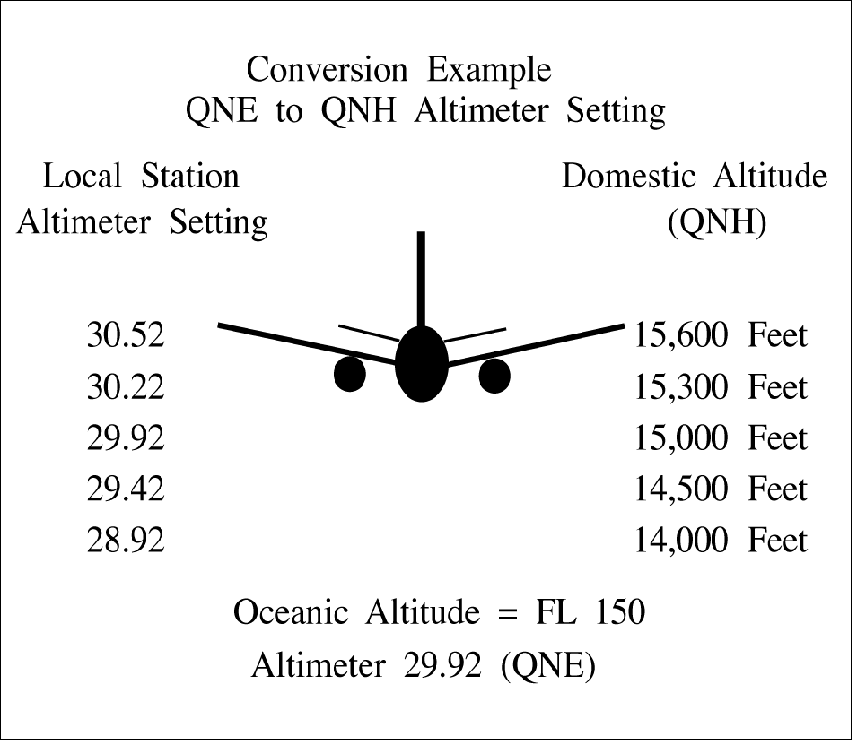
When vertical separation is applied between aircraft
crossing the offshore/oceanic airspace boundary
below FL 180, control action must be taken to ensure
that differences between the standard altimeter
setting (QNE) and local altimeter setting (QNH) do
not compromise separation. (See FIG 8-5-1.)
FIG 8-5-1
Standard and Local Altimeter Setting Differences
8-5-2. COURSE DIVERGENCE
When aircraft are entering oceanic airspace,
separation will exist in oceanic airspace when:
a. Aircraft are established on courses that diverge
by at least 15 degrees until oceanic lateral separation
is established, and
b. The aircraft are horizontally radar separated and
separation is increasing at the edge of known radar
coverage.
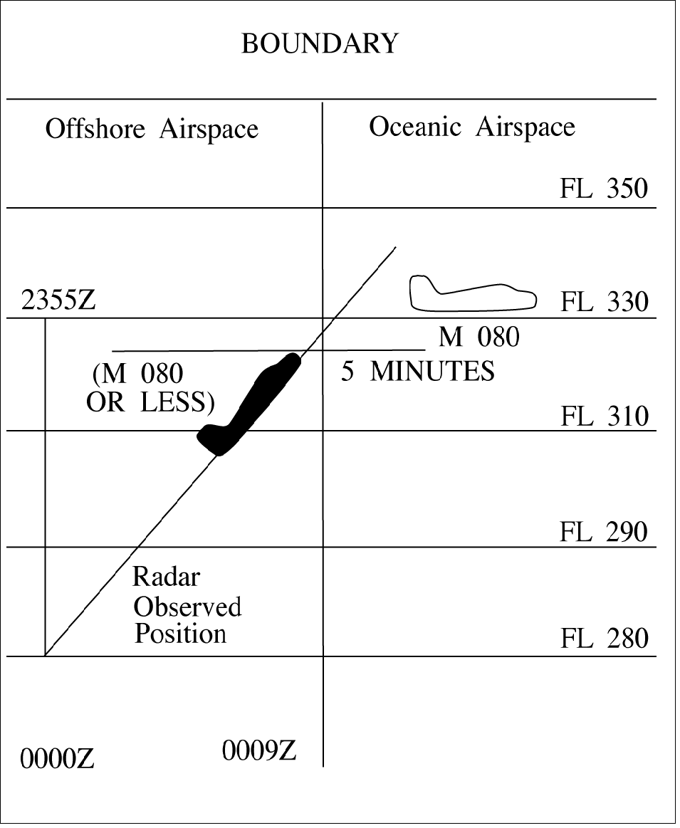
8-5-3. OPPOSITE DIRECTION
When transitioning from an offshore airspace area to
oceanic airspace, an aircraft may climb through
opposite direction oceanic traffic provided vertical
separation above that traffic is established:
a. Before the outbound crosses the offshore/oceanic boundary; and
b. 15 minutes before the aircraft are estimated to
pass. (See FIG 8-5-2.)
FIG 8-5-2
Transitioning From Offshore to Oceanic Airspace
Opposite Direction

8-5-4. SAME DIRECTION
When transitioning from an offshore airspace area to
oceanic airspace or while within oceanic airspace,
apply 5 minutes minimum separation when a
following aircraft on the same course is climbing
through the altitude of the preceding aircraft if the
following conditions are met:
a. The preceding aircraft is level at the assigned
altitude and is maintaining a speed equal to or greater
than the following aircraft; and
b. The minimum of 5 minutes is maintained
between the preceding and following aircraft; and
c. The following aircraft is separated by not more
than 4,000 feet from the preceding aircraft when the
climb clearance is issued; and
d. The following aircraft commences climb within
10 minutes after passing:
1. An exact reporting point (DME fix or
intersection formed from NAVAIDs) which the
preceding aircraft has reported; or
2. A radar observed position over which the
preceding aircraft has been observed; and
e. The following aircraft is in direct communication with air traffic control until vertical separation is
established. (See FIG 8-5-3.)
FIG 8-5-3
Transitioning From Offshore to Oceanic Airspace
Same Direction
855. RADAR IDENTIFICATION
APPLICATION
Radar separation standards may be applied
between radar identified aircraft and another
aircraft not yet identified that is in transit from
oceanic airspace or non-radar offshore airspace
into an area of known radar coverage where
radar separation is applied provided:
a.
Direct radio communications is maintained
with one of the aircraft involved and there is an
ability to communicate with the other;
b.
The transiting aircraft is RNAV equipped;
c.
The performance of the radar/system is
adequate;
REFERENCE-
FAA Order JO 7110.65, Para 511, Presentation and Equipment
Performance
d.
Flight data on the aircraft that has not been
radar identified indicate that it is equipped with
a standard transponder and there is no known
information that the transponder is not
operating;
e.
Radar separation standards are maintained
between the radar identified aircraft and any
other observed targets until the transitioning
aircraft is radar identified or nonradar
separation is established;
f.
The facility has identified areas of known
radar coverage, incorporated those areas into
facility standard operating procedures (SOP),
and provided training to the controllers.
g.
This procedure is also applicable to aircraft
in transit from oceanic airspace into Guam
Control Area (CTA), San Juan CTA and
Honolulu CTA radar coverage areas.
h. EXCEPTION: This procedure is not
authorized if there is insufficient time for the
controller to establish other approved
separation in the event of a delay or inability to
establish radar identification of the transiting
aircraft taking into consideration factors such as
aircraft performance characteristics, type, and
speed; weather, traffic conditions; workload;
frequency congestion; etc.
REFERENCE-
FAA Order JO 7110.65, Para 226,IFR Flight Progress Data,
Subpara 226.b.
FAA Order JO 7110.65, Para 818, use of Control Estimates
|