
Fox 3 High/Low, Paxon High/Low, and Delta 5 Military Operations Areas (MOA)
Big Delta, AK
Effective: beginning November 8, 2018
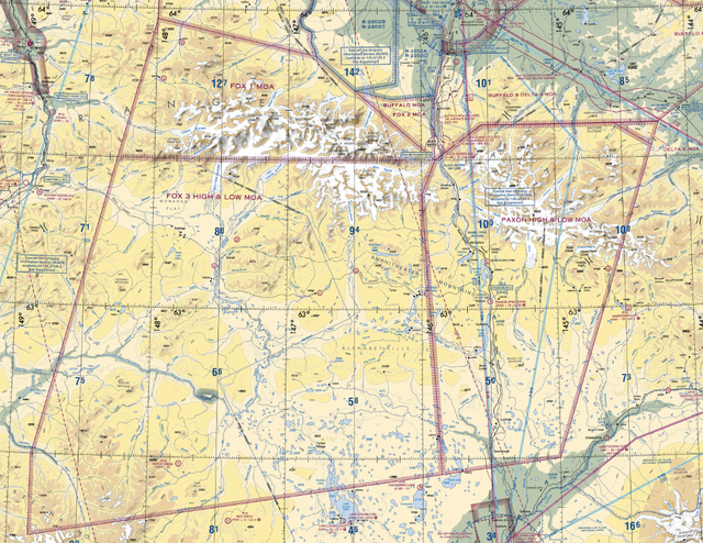
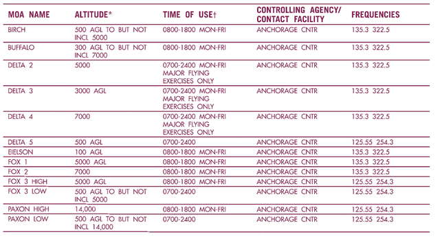
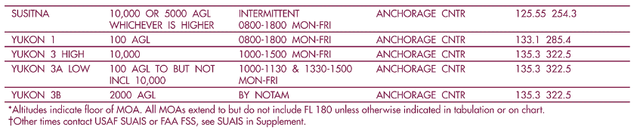
New airspace: Fox 3 High/Low, Paxon High/Low, and Delta 5 Military Operations Areas (MOAs) in the vicinity of Big Delta, AK will be effective November 8, 2018. The printed/folded chart copies of the Anchorage Sectional 103rd Edition (effective November 8, 2018) do not depict this airspace. A depiction of the new airspace and coordinates are provided below. Also provided is a corrected inset table showing altitude structure, time of use, controlling agency and contact frequencies.
Digital copies of the corrected sectional charts are available at https://www.faa.gov/air_traffic/flight_info/aeronav/digital_products/vfr/
Anchorage Sectional depiction of missing airspace:
Coordinates for the new airspaces are as follows:
Fox 3 High MOA, AK
Boundaries: Beginning at lat. 63°30'00" N., long. 145°54'00" W.;
to lat. 63°23'00" N., long. 146°00'00" W.;
to lat. 62°26'53" N., long. 145°51'33" W.;
to lat. 62°13'35" N., long. 148°50'50" W.;
to lat. 62°30'00" N., long. 148°50'50" W.;
to lat. 63°30'00" N., long. 148°16'46" W.;
to the point of beginning.
Fox 3 Low MOA, AK
Boundaries: Beginning at lat. 63°30'00" N., long. 145°54'00" W.;
to lat. 63°23'00" N., long. 146°00'00" W.;
to lat. 62°26'53" N., long. 145°51'33" W.;
to lat. 62°13'35" N., long. 148°50'50" W.;
to lat. 62°30'00" N., long. 148°50'50" W.;
to lat. 63°30'00" N., long. 148°16'46" W.;
to the point of beginning.
Paxon High MOA, AK
Boundaries: Beginningat lat. 63°30'00" N., long. 145°54'00" W.;
to lat. 63°37'00" N., long. 145°33'00" W.;
to lat. 63°37'00" N., long. 144°33'14" W.;
to lat. 63°32'22" N., long. 144°16'22" W.;
to lat. 62°30'00" N., long. 145°00'00" W.;
to lat. 62°26'53" N., long. 145°51'33" W.;
to lat. 63°23'00" N., long. 146°00'00" W.;
to the point of beginning.
Paxon Low MOA, AK
Boundaries: Beginningat lat. 63°30'00" N., long. 145°54'00" W.;
to lat. 63°37'00" N., long. 145°33'00" W.;
to lat. 63°37'00" N., long. 144°33'14" W.;
to lat. 63°32'22" N., long. 144°16'22" W.;
to lat. 62°30'00" N., long. 145°00'00" W.;
to lat. 62°26'53" N., long. 145°51'33" W.;
to lat. 63°23'00" N., long. 146°00'00" W.;
to the point of beginning.
Delta 5 MOA, AK
Boundaries: Beginning at lat. 63°37'00" N., long. 144°33'14" W.;
to lat. 63°37'00"N., long. 144°13'00" W.;
to lat. 63°32'22" N., long. 144°16'22" W.;
to the point of beginning.
Anchorage Sectional inset table:
//END//