Section 5. Lateral Separation
6-5-1. SEPARATION METHODS
Separate aircraft by one of the following methods:
a. Clear aircraft on different airways or routes
whose widths or protected airspace do not overlap.
b. Clear aircraft below 18,000 to proceed to and
report over or hold at different geographical locations
determined visually or by reference to NAVAIDs.
c. Clear aircraft to hold over different fixes whose
holding pattern airspace areas do not overlap each
other or other airspace to be protected.
d. Clear departing aircraft to fly specified
headings which diverge by at least 45 degrees.
6-5-2. MINIMA ON DIVERGING RADIALS
a. Consider separation to exist between aircraft:
1. Established on radials of the same NAVAID
that diverge by at least 15 degrees when either aircraft
is clear of the airspace to be protected for the other
aircraft.
2. With non-VOR/DME based navigational
equipment established on tracks of the same
waypoint that diverge by at least 15 degrees when
either aircraft is clear of the airspace to be protected
for the other aircraft.
FIG 6-5-1
Minima on Diverging Radials
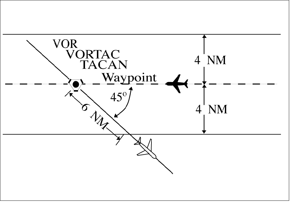
NOTE-
The procedure may be applied to converging as well as
diverging aircraft. (See FIG 6-5-1.) The aircraft depicted
6 miles from the NAVAID/waypoint would require vertical
separation until reaching the 6-mile point. Reversing
direction, the same aircraft would require vertical
separation before passing the 6-mile point. Due to the
nature of GPS equipment, issue crossing restrictions in
reference to the next waypoint, since the pilot receives
tracking “to” data rather than tracking “from” the last
waypoint.
b. Use TBL 6-5-1 and TBL 6-5-2 to determine
the distance required for various divergence angles to
clear the airspace to be protected. For divergence that
falls between two values, use the lesser divergence
value to obtain the distance.
TBL 6-5-1
Non-DME Divergence
Distance Minima
|
Divergence (Degrees)
|
Distance (NM)
|
|
15
|
16
|
|
20
|
12
|
|
25
|
10
|
|
30
|
8
|
|
35
|
7
|
|
45
|
6
|
|
55
|
5
|
|
90
|
4
|
|
NOTE: This table is for non-DME application only.
|
TBL 6-5-2
Divergence
Distance Minima
|
Divergence
(Degrees)
|
Distance (NM)
|
|
|
Below FL 180
|
Fl 180 through
FL 450
|
|
15
|
17
|
18
|
|
20
|
13
|
15
|
|
25
|
11
|
13
|
|
30
|
9
|
11
|
|
35
|
8
|
11
|
|
45
|
7
|
11
|
|
55
|
6
|
11
|
|
90
|
5
|
11
|
|
NOTE: This table is for DME application and
compensates for DME slant-range error.
|
NOTE-
For altitudes of 3,000 feet or less above the elevation of the
NAVAID, DME slant-range error is negligible and the
values in TBL 6-5-1 may be used.
6-5-3. DME ARC MINIMA
Apply lateral DME separation by requiring aircraft
using DME to fly an arc about a NAVAID at a
specified distance using the following minima:
(See FIG 6-5-2.)
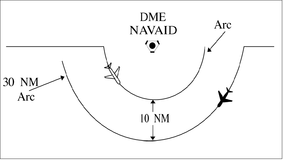
REFERENCE-
FAAO JO 7110.65, Para 2-5-2, NAVAID Terms.
a. Between different arcs about a NAVAID
regardless of direction of flight:
1. At 35 miles or less from the NAVAID-
10 miles.
2. More than 35 miles from the NAVAID-
20 miles.
b. Between an arc about a NAVAID and other
airspace to be protected: (See FIG 6-5-3.)
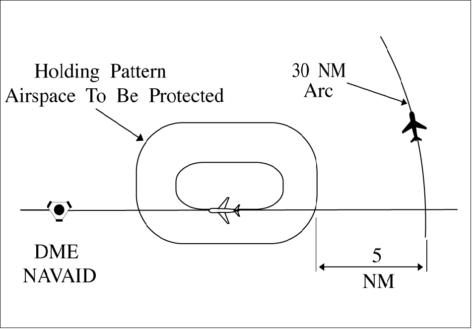
NOTE-
The other airspace to be protected may be a MOA, a
holding pattern, airway or route, ATCAA, Warning Area,
Restricted Area, Prohibited Area, etc.
1. At 35 miles or less from the NAVAID-
5 miles.
2. More than 35 miles from the NAVAID-
10 miles.
PHRASEOLOGY-
VIA (number of miles) MILE ARC (direction) OF (name of
DME NAVAID).
6-5-4. MINIMA ALONG OTHER THAN
ESTABLISHED AIRWAYS OR ROUTES
Protect airspace along other than established airways
or routes as follows: (See FIG 6-5-4.)
FIG 6-5-4
Minima Along Other Than
Established Airways or Routes
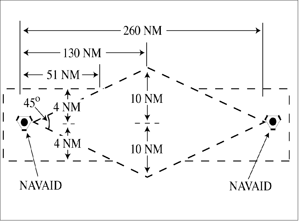
REFERENCE-
P/CG Term- Airway.
P/CG Term- Route.
a. Direct courses and course changes of 15 degrees
or less:
1. Via NAVAIDs or radials FL 600 and below-
4 miles on each side of the route to a point 51 miles
from the NAVAID, then increasing in width on a
4 1/2 degree angle to a width of 10 miles on each side
of the route at a distance of 130 miles from the
NAVAID.
2. Via degree-distance fixes for aircraft authorized under para 4-4-3, Degree-Distance
Route Definition for Military Operations.
(a) Below FL 180- 4 miles on each side of the
route.
(b) FL 180 to FL 600 inclusive- 10 miles on
each side of the route.
3. Via degree-distance fixes for RNAV flights
above FL 450- 10 miles on each side of the route.
NOTE-
Except for GNSSequipped aircraft /G, /L, /S, and /V, not on
a random impromptu route, Paragraph 551, Application,
requires radar separation be provided to RNAV aircraft
operating at and below FL450 on Q routes or random
RNAV routes, excluding oceanic airspace.
REFERENCE-
FAAO JO 7110.65, Para 442, Route Structure Transitions.
FAAO JO 7110.65, Para 551, Application.
P/CG Term Global Navigation Satellite System (GNSS)[ICAO].
4. GNSSequipped RNAV aircraft provided
nonradar separation on random RNAV routes must
be cleared via or reported to be established on
pointtopoint route segments.
(a) The points must be published NAVAIDs,
waypoints, fixes, or airports recallable from the
aircraft's navigation database. The points must be
displayed on controller video maps or depicted on the
controller chart displayed at the control position. The
maximum distance between points must not exceed
500 miles.
(b) Protect 4 miles either side of the route
centerline.
(c) Assigned altitudes must be at or above the
highest MIA along the projected route segment being
flown, including the protected airspace of that route
segment.
(d) When the GNSS aircraft is being provided
radar service and is transitioning to nonradar
airspace, provide clearance direct to the named point
in nonradar airspace in accordance with subparagraphs a4(a) through (c).
EXAMPLE-
A pilot has filed a pointtopoint route from XYZ to ABC at
13,000 feet. Departure procedures from the originating
airport place the aircraft a significant distance from XYZ;
however, the aircraft can establish itself along the route
segment from XYZ to ABC. Ascertain when the pilot is
established on the pointtopoint route segment and at an
altitude, which meets or exceeds the highest MVA/MIA
projected along the route of flight, then issue a clearance.
“Verify when you are established on the XYZ to ABC route
segment at or above 6,000 feet.”
REFERENCE-
FAAO JO 7110.65, Para 442, Route Structure Transitions
FAAO JO 7110.65, Para 551, Application
b. When course change is 16 degrees through
90 degrees, protect the airspace on the overflown side
beginning at the point where the course changes as
follows: (See FIG 6-5-5.)
FIG 6-5-5
Overflown Side Minima
16 to 90 Degrees
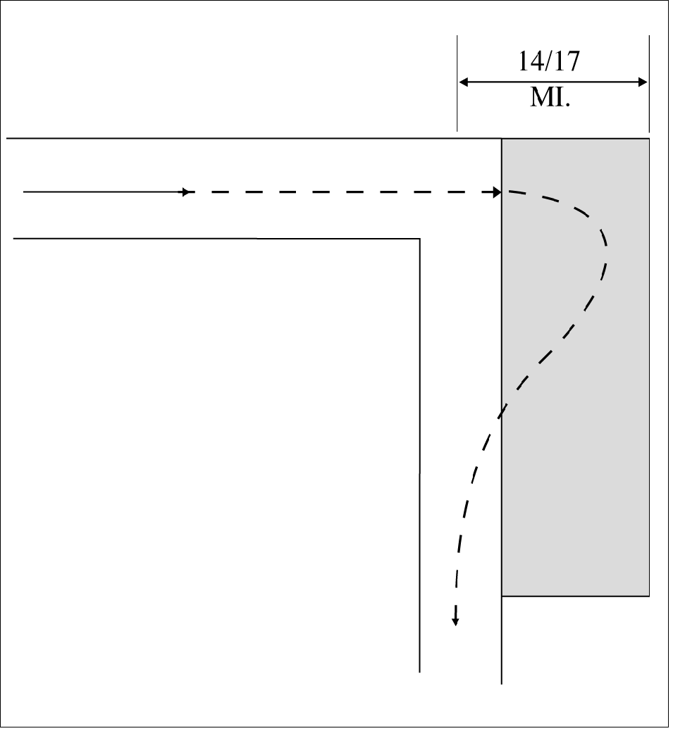
1. Below FL 180- same as subparas a1 or 2.
2. FL 180 to FL 230 inclusive- 14 miles.
3. Above FL 230 to FL 600 inclusive- 17 miles.
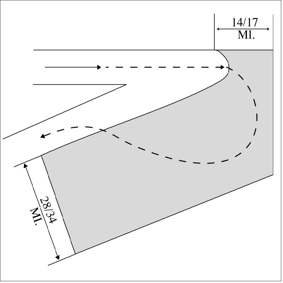
c. When course change is 91 degrees through
180 degrees, protect the airspace on the overflown
side beginning at the point where the course changes
as follows: (See FIG 6-5-6.)
1. Below FL 180- same as subparas a1 or 2.
2. FL 180 to FL 230 inclusive- 28 miles.
3. Above FL 230 to FL 600 inclusive- 34 miles.
FIG 6-5-6
Overflown Side Minima
91 to 180 Degrees
d. After the course changes specified in subparas b or c have been completed and the aircraft is
back on course, the appropriate minima in subpara a
may be used.
REFERENCE-
FAAO JO 7110.65, Para 9-2-13, Military Operations Above
FL 600.
EN ROUTE
e. For aircraft equipped with IFR-certified GPS
systems operating within Anchorage Air Route
Traffic Control Center controlled airspace (excluding
oceanic airspace) where ATC surveillance coverage
is not available:
1. Aircraft must be cleared via point-to-point
route segments. Points are defined as: NAVAIDS,
intersections, airports, and waypoints.
2. Lateral protected airspace must be 4 nautical
miles (NM) either side of the projected centerline
between the points.
3. Points used for navigation must be named and
depicted on the controller video map, and/or on the
controller chart(s) located at the position.
4. The maximum distance between successive
fixes/waypoints must not exceed 512 miles.
5. Assigned altitudes must be at or above the
highest minimum IFR altitude (MIA) along the
projected route, including the protected airspace of
that route, for the route segment being flown.
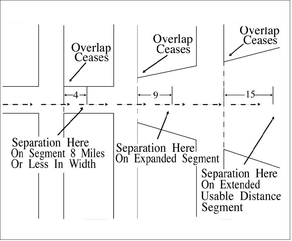
6-5-5. RNAV MINIMA- DIVERGING/CROSSING COURSES
Consider lateral separation to exist when an RNAV
aircraft is beyond the point where the lateral protected
airspace of that aircraft has ceased to overlap the
lateral protected airspace of another by at least:
(See FIG 6-5-7 and FIG 6-5-8.)
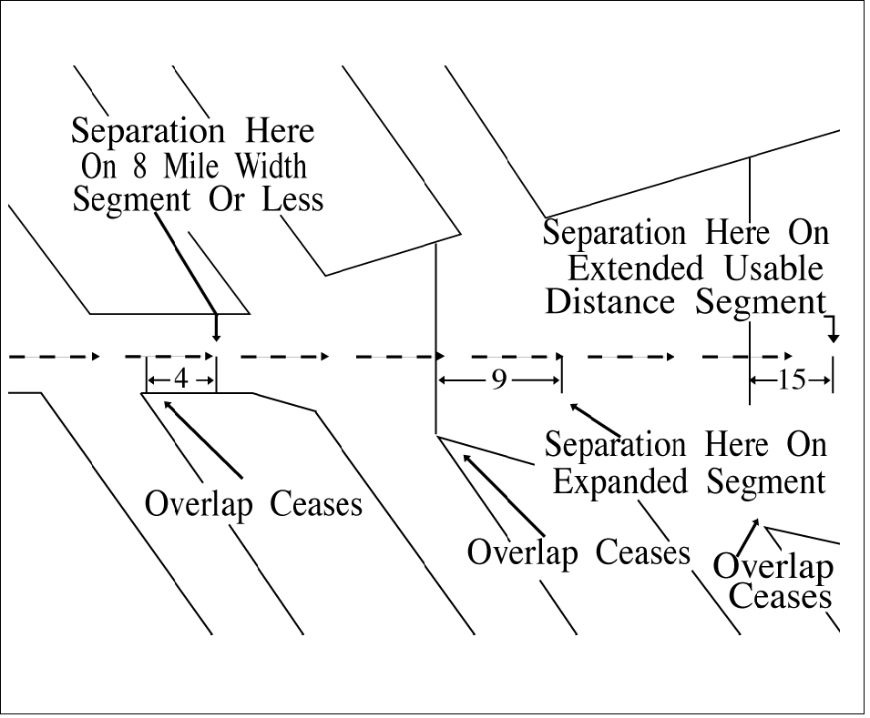
a. When operating along a route that is 8 miles or
less in width- 4 miles.
b. When operating along an expanded route-
9 miles, except that 15 miles must be applied along
that portion of any route segment requiring extended
usable distance limitation beyond 130 miles of the
reference facility.
NOTE-
Except for GNSSequipped aircraft /G, /L, /S, and /V, not on
a random impromptu route, Paragraph 551, Application,
requires radar separation be provided to RNAV aircraft
operating at and below FL450 on Q routes or random
RNAV routes, excluding oceanic airspace.
|
