Special Use Airspace Juniper and Hart Military Operations Areas
Oregon
Effective Dates: December 7, 2017
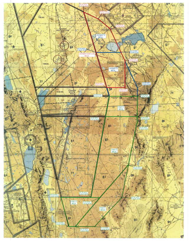
On December 7, 2017, the JUNIPER/HART airspace complex will expand slightly to the east and to the south and the naming convention will change. This NTAP will be carried until March 29, 2018 when it will be charted on the Klamath Falls VFR Sectional. The specifics are outlined below.
Historically, the JUNIPER/HART MOAs have accommodated high altitude supersonic beyond visual range mission set-up ranges. However, due to the increased long range capabilities of the F-l 5C, and similar emerging threat capabilities of adversary aircraft, existing space within the JUNIPER/HART MOAs has been inefficient within recent years to provide realistic mission-oriented training.
Therefore, the eastern boundary of the existing JUNIPER/HART airspace complex is extended approximately 20 miles to the east and the southern boundary is extended approximately 20 miles to the south. The airspace segments are renamed alphabetically to include: JUNIPER A through D MOAs and HART A through E MO As. Expansion of the existing JUNIPER LOW MOA include the new JUNIPER EAST LOW MOA located directly underneath the new JUNIPER C MOA and a majority of the new JUNIPER D MOA. The new JUNIPER EAST LOW MOA is established from 500 feet above ground level (AGL) to 10,999 feet MSL. In addition, the floor of the existing JUNIPER LOW MOA is raised from 300 feet AGL to 500 feet AGL. The new airspace will be activated on an as-needed basis as a whole or individually.
Juniper Low MOA, OR [Delete]
Juniper North MOA, OR [Delete]
Juniper South MOA, OR [Delete]
Hart North MOA, OR [Delete]
Hart South MOA, OR[Delete]
Juniper A MOA, OR [New]
Boundaries . Beginning at lat. 43°55'59"N., long. 120°44'04"W.;
to lat. 43°57'05"N., long. 120°26'24"W.;
to lat. 43°50'30"N., long. 120°07'48"W.;
to lat. 43°21'00"N., long.120°31'48"W.;
to the point of beginning.
Altitudes . 11,000 feet to but not including FL 180.
Times of Use . Intermittent by NOTAM.
Controlling Agency . FAA, Seattle ARTCC.
Using Agency . USAF, 173 FW, Kingsley Field, Klamath Falls. OR.
Juniper B MOA, OR [New]
Boundaries . Beginning at lat. 43°21'00"N., long. 120°31'48"W.;
to lat. 43°50'30"N., long. 120°07'48"W.;
to lat. 43°38'00"N., long. 119°34'00"W.;
to lat. 42°40'00"N., long. 119°10'04"W.;
to lat. 42°40'00"N., long. 120°18'04"W.;
to the point of beginning.
Altitudes . 11,000 feet MSL to but not including FL 180.
Times of Use . Intermittent by NOTAM.
Controlling Agency . FAA, Seattle ARTCC.
Using Agency . USAF, 173 FW, Kingsley Field, Klamath Falls. OR.
Juniper C MOA, OR [New]
Boundaries. Beginning at lat. 43°38’00"N., long. 119°34’04"W.;
to lat. 43°33’19"N., long. 119°20’17"W.;
to lat. 43°26’41"N., long. 119°09’26"W.;
to lat. 43°10’08"N., long. 118°59’03"W.;
to lat. 43°10’08"N., long. 119°22’26"W.;
to the point of beginning.
Altitudes . 11,000 feet MSL to but not including FL 180.
Times of Use . Intermittent by NOTAM.
Controlling Agency . FAA, Seattle ARTCC.
Using Agency . USAF, 173 FW, Kingsley Field, Klamath Falls. OR.
Juniper D MOA, OR [New]
Boundaries . Beginning at lat. 43°10’08"N., long. 119°22’26"W.;
to lat. 43°10’08"N., long. 118°59’03"W.;
to lat. 42°46’00"N., long. 118°43’53"W.;
to lat. 42°40’00"N., long. 118°43’53"W.;
to lat. 42°40’00"N., long. 119°10’04"W.;
to the point of beginning.
Altitudes . 11,000 feet MSL to but not including FL 180.
Times of Use . Intermittent by NOTAM.
Controlling Agency . FAA, Seattle ARTCC.
Using Agency . USAF, 173 FW, Kingsley Field, Klamath Falls. OR.
Juniper East Low MOA, OR [New]
Boundaries . Beginning at lat. 43°38’00"N., long. 119°34’04"W.;
to lat. 43°33’19"N., long. 119°20’17"W.;
to lat. 43°26’41"N., long. 119°09’26"W.;
to lat. 43°04’20"N., long. 118°55’21"W.;
to lat. 42°46’00"N., long. 118°55’21"W.;
to lat. 42°46’00"N., long. 119°12’27"W.;
to the point of beginning.
Altitudes . 500 feet AGL to but not including 11,000 MSL.
Times of Use . Intermittent by NOTAM.
Controlling Agency . FAA, Seattle ARTCC.
Using Agency . USAF, 173 FW, Kingsley Field, Klamath Falls. OR.
Juniper Low MOA, OR [New]
Boundaries . Beginning at lat. 43°55'59"N., long. 120°44'04"W.;
to lat. 43°57'05"N., long. 120°26'24"W.;
to lat. 43°38'00"N., long. 119°34'04"W.;
to lat. 42°46'00"N., long. 119°12'27"W.;
to lat. 42°46'00"N., long. 120°20'01"W.;
to the point of beginning.
Excluding the airspace 1,500 feet AGL and below within a 3nm radius of the center of the Alkali Lake State and Wagontire Airports, Oregon.
Altitudes. 500 feet AGL to but not including 11,000 feet MSL.
Times of Use. Intermittent by NOTAM.
Controlling Agency. FAA, Seattle ARTCC.
Using Agency. USAF, 173 FW, Kingsley Field, Klamath Falls. OR.
Hart A MOA, OR [New]
Boundaries . Beginning at lat. 42°40’00"N., long. 120°18’04"W.;
to lat. 42°40’00"N., long. 119°10’04"W.;
to lat. 42°26’00"N., long. 119°13’34"W.;
to lat. 42°26’00"N., long. 120°13’06"W.;
to the point of beginning.
Altitudes . 11,000 feet MSL to but not including FL 180.
Times of Use . Intermittent by NOTAM.
Controlling Agency . FAA, Seattle ARTCC.
Using Agency . USAF, 173 FW, Kingsley Field, Klamath Falls. OR.
Hart B MOA, OR [New]
Boundaries . Beginning at lat. 42°26’00"N., long. 120°13’06"W.;
to lat. 42°26’00"N., long. 119°13’34"W.;
to lat. 41°30’00"N., long. 119°27’04"W.;
to lat. 41°30’00"N., long. 119°55’04"W.;
to the point of beginning.
Altitudes . 11,000 feet MSL to but not including FL 180.
Times of Use . Intermittent by NOTAM.
Controlling Agency . FAA, Seattle ARTCC.
Using Agency . USAF, 173 FW, Kingsley Field, Klamath Falls. OR.
Hart C MOA, OR [New]
Boundaries . Beginning at lat. 42°40’00"N., long. 119°10’04"W.;
to lat. 42°40’00"N., long. 118°43’53"W.;
to lat. 42°26’00"N., long. 118°43’53"W.;
to lat. 42°26’00"N., long. 119°13’34"W.;
to the point of beginning.
Altitudes . 11,000 feet MSL to but not including FL 180.
Times of Use . Intermittent by NOTAM.
Controlling Agency . FAA, Seattle ARTCC.
Using Agency . USAF, 173 FW, Kingsley Field, Klamath Falls. OR.
Hart D MOA, OR [New]
Boundaries . Beginning at lat. 42°26’00"N., long. 119°13’34"W.;
to lat. 42°26’00"N., long. 118°43’53"W.;
to lat. 42°22’34"N., long. 118°43’53"W.;
to lat. 41°52’44"N., long. 118°52’07"W.;
to lat. 41°30’00"N., long. 119°18’36"W.;
to lat. 41°30’00"N., long. 119°27’04"W.;
to the point of beginning.
Altitudes. 11,000 feet MSL to but not including FL 180.
Times of Use . Intermittent by NOTAM.
Controlling Agency . FAA, Seattle ARTCC.
Using Agency . USAF, 173 FW, Kingsley Field, Klamath Falls. OR.
Hart E MOA, OR [New]
Boundaries . Beginning at lat. 41°30’00"N., long. 119°55’04"W.;
to lat. 41°30’00"N., long. 119°27’04"W.;
to lat. 41°30’00"N., long. 119°18’36"W.;
to lat. 41°10’00"N., long. 119°41’40"W.;
to lat. 41°10’00"N., long. 119°47’30"W.;
to the point of beginning.
Altitudes . 11,000 feet MSL to but not including FL 180.
Times of Use . Intermittent by NOTAM.
Controlling Agency . FAA, Seattle ARTCC.
Using Agency . USAF, 173 FW, Kingsley Field, Klamath Falls. OR.
Hart F MOA, OR [New]
Boundaries . Beginning at lat. 41°52’44"N., long. 118°52’07"W.;
to lat. 41°30’00"N., long. 118°58’19"W.;
to lat. 41°10’00"N., long. 119°23’36"W.;
to lat. 41°10’00"N., long. 119°41’40"W.;
to lat. 41°30’00"N., long. 119°18’36"W.;
to the point of beginning.
Altitudes . 11,000 feet MSL to but not including FL 180.
Times of Use . Intermittent by NOTAM.
Controlling Agency . FAA, Seattle ARTCC.
Using Agency . USAF, 173 FW, Kingsley Field, Klamath Falls. OR.