Section 2 International Oceanic Airspace Notices
Introduction
The following information contains the most current notices involving airspace matters pertaining to U.S. internationally delegated airspace. The information provided is divided into two sections: General and Region Specific.
Failure to Comply with ATC Clearances in Oceanic Airspace
The FAA has identified categories of problematic events that continue to occur in oceanic operations. These events involve pilots either not complying with an ATC clearance or not adhering to Oceanic Weather Deviation Procedures published in ICAO Document 4444 (Procedures for Air Navigation Services, Air Traffic Management), and which are reprinted in the Aeronautical Information Manual (AIM), and in the United States Aeronautical Information Publication (AIP). The following are descriptions of problematic categories:
-
Failure to comply with Conditional Clearances. Pilots continue to disregard the time restriction in conditional clearances. For example, with the following clearance issued at 1200: "MAINTAIN FL 350, AT 1210 CLIMB TO AND MAINTAIN FL370, REPORT REACHING," pilots frequently climb right away instead of waiting for the time restriction (in this case, 1210).
-
Failure to Update Time Estimates. Pilots continue to provide inaccurate estimated times of arrival (ETAs). ICAO Annex 2 requires pilots to notify ATC if the originally provided estimate changes in excess of 2 minutes from that previously notified. ETAs can be affected by weather deviations, speed changes, and/or inaccurate winds or speeds in the navigation computer.
-
Failure to Coordinate Altitude Clearance. Pilots continue to climb without clearance to the altitude associated with the oceanic clearance and/or an en route filed level change (in Item 15 of the flight plan). Such vertical clearances need to be coordinated with ATC.
-
Non-adherence to Oceanic Weather Deviation Procedures. Pilots continue to deviate around weather without requesting clearances from ATC. Only if conditions preclude such coordination should pilots deviate without a clearance, and if such un-cleared deviations are necessary, pilots should adhere to the ICAO Weather Deviation Procedures referenced above.
-
Non-compliance with Revised Clearances. Pilots continue to fly the filed flight plan routing instead of the ATC cleared routing. Pilots whose oceanic clearances differ from the filed routing in many cases fail to re-program navigation computers with the revised route of flight.
Failure to comply with ATC clearances is a major cause of risk in oceanic airspace. Requirements to comply with ATC clearances are published in paragraph 3.6.2 (Adherence to flight plan) of ICAO Annex 2 (Rules of the Air) and 14 CFR (Code of Federal Regulations), Part 91, Section 91.123 (Compliance with ATC clearances and instructions).
Operators must stress in pilot training and operations manuals the necessity to:
-
Comply fully with an ATC clearance.
-
Obtain a revised clearance prior to deviating from cleared track or flight level or, if unable to obtain a clearance prior to deviating, follow the appropriate deviation procedure for oceanic airspace (weather deviation or in-flight contingency).
-
Adhere to the provisions of published Weather Deviation Procedures.
-
Questions on this Notice may be directed to one of the following:
Madison Walton (FAA Flight Standards Performance Based Flight Systems Branch),
Phone (1) 202-267-8850; E-mail:
Madison.Walton@faa.gov
Kevin Kelley (FAA Flight Standards Performance Based Flight Systems Branch).
Phone (1) 202-863-8854; E-mail:
Kevin.C.Kelley@faa.gov
(Performance Based Flight Systems Branch, AFS-470, 7/10/2017)
General
Special Notice - Lost Communications
If the pilot of an aircraft operating in international airspace under U.S. jurisdiction and equipped with a coded radar beacon transponder experiences a loss of two-way radio capability, the pilot should:
-
Adjust the transponder to reply on Mode 3/A, Code 7700 for a period of 1 (one) minute.
-
Then change to code 7600 and remain on 7600 for a period of 15 minutes or the remainder of the flight, whichever occurs first.
-
Repeat steps 1 and 2 as practicable.
Special Notice -- Inspection of Means of Conveyance for Aircraft Departing Continental United States
Inspection of aircraft prior to departure. No person shall move any aircraft from Hawaii to the continental United States, Puerto Rico, or the Virgin Islands of the United States, unless the person moving the aircraft has contacted an inspector and offered the inspector the opportunity to inspect the aircraft prior to departure and the inspector has informed the person proposing to move the aircraft that the aircraft may depart.
Inspection of aircraft moving to Guam. Any person who has moved an aircraft from Hawaii to Guam shall contact an inspector and offer the inspector the opportunity to inspect the aircraft upon the aircraft's arrival in Guam, unless the aircraft has been inspected and cleared in Hawaii prior to departure in accordance with arrangements made between the operator of the aircraft, the Animal and Plant Inspection Service, and the government of Guam.
(USDA Regulation 318.13-9)
Special Notice - Change to Controller Pilot Data Link Communications - Departure Clearance (CPDLC-DCL) Logon for Departure Clearance
-
Purpose This notice serves to inform that a portion of the aviation community which receives departure clearances via CPDLC-DCL at appropriately equipped U.S. airports of a change to the logon needed to receive the clearance. This logon change happens October 20-21, 2017.
-
Procedure . CPDLC-DCL requires a logon to the FAA National Single Data Authority - KUSA - utilizing the ATC FANS application.
(AJV-84, 11/9/2017)
Performance Based Communications and Surveillance (PBCS) Based Changes for FAA Form 7233-4
Background - To fulfill international agreements, and in accordance with International Civil Aviation Organization Annex 6, Annex 11, and Document 4444, the FAA is implementing Performance-Based Communication and Surveillance (PBCS) requirements and monitoring on March 29, 2018. To support this, aircraft must file their equipment capabilities using ICAO aircraft communication, navigation, and approach equipment qualifiers. Most of these equipage qualifiers are already in use. However, the qualifiers to describe an aircraft’s Required Communication Performance (RCP), also known as P-Codes, were not in use. Aircraft will be required to file P-Codes in their flight plan in order to be eligible for reduced separation standards in the oceanic portions of their flights.
Explanation of Change - The "Reserved for RCP" description for the P-Code includes the P-Code equipment definitions for P1 - P3. This change adds guidance for the filing of Required Surveillance Performance (RSP) information in Item 18 of the flight plan. Additionally, this change indicates flight planning requirements to be eligible for 50 NM longitudinal and lateral separation and 30 NM longitudinal and lateral separation as well as aircraft and operator eligibility for 30 NM distance−based separation.
Item 10 - Aircraft COM, NAV, AND Approach Equipment Qualifiers
INSERT one letter as follows:
N if no COM/NAV/approach aid equipment for the route to be flown is carried, or the equipment is unserviceable,
(OR)
S if standard COM/NAV/approach aid equipment for the route to be flown is carried and serviceable (see Note 1),
(AND/OR)
INSERT one or more of the following letters to indicate the COM/NAV/approach aid equipment available and serviceable:
NOTE−
The capabilities described below comprise the following elements:
a. Presence of relevant serviceable equipment on board the aircraft.
b. Equipment and capabilities commensurate with flight crew qualifications.
c. Where applicable, authorization from the appropriate authority.
|
A |
GBAS landing system |
L |
ILS |
|
B |
LPV (APV with SBAS) |
M1 |
ATC RTF SATCOM (INMARSAT) |
|
C |
LORAN C |
M2 |
ATC RTF (MTSAT) |
|
D |
DME |
M3 |
ATC RTF (Iridium) |
|
E1 |
FMC WPR ACARS |
O |
VOR |
|
E2 |
D-FIS ACARS |
P1 |
CPDLC RCP 400 ( See Note 7) |
|
E3 |
PDC ACARS |
P2 |
CPDLC RCP 240 ( See Note 7) |
|
F |
ADF |
P3 |
SATVOICE RCP 400 ( See Note 7) |
|
G |
(GNSS) - see Note 2 |
P4-P9 |
Reserved for RCP |
|
H |
HF RTF |
R |
PBN approved - see Note 4 |
|
I |
Inertial navigation |
T |
TACAN |
|
J1 |
CPDLC ATN VDL Mode 2 - see Note 3 |
U |
UHF RTF |
|
J2 |
CPDLC FANS 1/A HFDL |
V |
VHF RTF |
|
J3 |
CPDLC FANS 1/A VDL Mode 4 |
W |
RVSM approved |
|
J4 |
CPDLC FANS 1/A VDL Mode 2 |
X |
MNPS approved/North Atlantic (NAT) High Level Airspace (HLA) approved |
|
J5 |
CPDLC FANS 1/A SATCOM (INMARSAT) |
Y |
VHF with 8.33 kHz channel spacing capability |
|
J6 |
CPDLS FANS 1/A SATCOM (MTSAT) |
Z |
Other equipment carried or other capabilities -- see Note 5 |
|
J7 |
CPDLC FANS 1/A SATCOM (Iridium) |
L |
ILS |
NOTE−
If the letter S is used, standard equipment is considered to be VHF RTF, VOR, and ILS within U.S. domestic airspace.
If the letter G is used, the types of external GNSS augmentation, if any, are specified in Item 18 following the indicator NAV/ and separated by a space.
See RTCA/EUROCAE Interoperability Requirements Standard For ATN Baseline 1 (ATN B1 INTEROP Standard - DO-280B/ED-110B) for data link services air traffic control clearance and information/air traffic control communications management/air traffic control microphone check.
If the letter R is used, the performance−based navigation levels that are authorized must be specified in Item 18 following the indicator PBN/. For further details, see Paragraph 5−1−9 b 8, Item 18 (c) and (d).
If the letter Z is used, specify in Item 18 the other equipment carried, preceded by COM/, DAT/, and/or NAV/, as appropriate.
Information on navigation capability is provided to ATC for clearance and routing purposes.
Guidance material on the application of performance-based communication, which prescribes RCP to an air traffic service in a specific area, is contained in the Performance-based Communication and Surveillance (PBCS) Manual (Doc 9869).
Item 18, Other Information
When Required Surveillance Performance (RSP) Capability has been filed in SUR/, this can be conveyed by inserting the character "Z" in Item 10 and "SUR/" in field 18 followed by the appropriate RSP performance per the following:
For RSP 180 - flight plan RSP180
For RSP 400 - flight plan RSP400
EXAMPLE -
SUR/ RSP180
SUR/ RSP400
SUR/ RSP180 RSP400
12.8 For a copy of FAA Form 7233−4, and for information on how to complete the form, please go to: www.faa.gov/ato?k=fpl.
Flight Planning Requirements
NOTE−
In addition to the following guidance, operators must also consult current Notices to Airmen (NOTAMs) and chart supplements (Supplement Alaska, Supplement Pacific) to gain a complete understanding of requirements. NOTAMs and supplements may contain guidance that is short term and/or short notice - i.e., having immediate effect.
If you are eligible for oceanic 50 NM longitudinal and lateral separation:
PBN/A1 or PBN/L1 in Field 18.
P2 in Field 10a.
D1 in Field 10b.
(J5, J6, or J7) and R in Field 10a.
SUR/RSP180 in Field 18
See FAA Advisory Circular 90-117 for guidance on RCP and RSP authorization.
See FAA Advisory Circular 90-105 for guidance on RNP 10 (RNAV 10) authorization.
If you are eligible for oceanic 30 NM longitudinal and lateral separation:
PBN/L1 in Field 18.
P2 in Field 10a.
D1 in Field 10b.
(J5, J6, or J7) and R in Field 10a.
SUR/RSP180 in Field 18.
See FAA Advisory Circular 90-117 for guidance on RCP and RSP authorization.
See FAA Advisory Circular 90-105 for guidance on RNP 4 authorization.
Aircraft and Operator Eligibility for 30 NM Distance−Based Separation
The aircraft and operator must be authorized by the State of the Operator or the State of Registry, as appropriate, for RNP 4, RCP 240 and RSP 180 operations;
Operators must use one of the following documents to develop policy and procedures for RNP 4 operations:
FAA Advisory Circular (AC) 90-105,
Approval Guidance for RNP Operations and Barometric Vertical Navigation in the U.S. National Airspace System and
in Oceanic and Remote Continental Airspace;
Australian Civil Aviation Safety Authority (CASA) Advisory Circular 91U3(0); New ICAO Performance Based Navigation
(PBN) Manual (new ICAO Document 9613), Volume II, Part C, Chapter 1; or New ICAO Performance Based Communication
and Surveillance (PBCS) Manual (new ICAO Document 9869).
(AJV-84, 12/7/2017)
Region Specific
Guidance for U.S. Operators: Special Emphasis Items for Operation In North Atlantic Reduced Lateral Separation Minimum (RLatSM) Trials
1 FEBRUARY 2018 UPDATE
-
Purpose of Notice. This notice provides information on the RLatSM trials being conducted in the ICAO North Atlantic (NAT) region and guidance on subject matter that should be included in pilot and dispatcher training programs and operating manuals concerning such operations. Paragraph 2 provides new information on the start of phase 2 of the trials, which had been delayed.
NOTE: Operators are encouraged to obtain their Performance Based Communications and Surveillance (PBCS) authorization before the 29 March 2018 scheduled start of NAT Organized Track System (OTS) lateral track spacing based on PBCS criteria. On 29 March 2018, the RLatSM trials will be replaced by 23 nautical mile (NM) (1/2-degree latitude) lateral track spacing for operators specifically authorized for PBCS and Performance Based Navigation (PBN) separation criteria. Three OTS tracks, between flight levels 350-390 inclusive, will be set aside for aircraft authorized for PBCS and PBN operations. Operators should contact their certificate management offices or flight standards offices for authorization information.
-
The " FAA NAT Resource Guide for U.S. Operators " provides information on NAT initiatives and programs, including this notice. It can be accessed at:
http://www.faa.gov/about/office_org/headquarters_offices/avs/offices/afs/afs400/afs470/media/NAT.pdf
It is recommended that "Google Chrome" be used to access this site.
-
Operator attention is directed to Attachment A. It provides a "quick reference" for the RLatSM Special Emphasis Items contained in this bulletin. It is intended to be used as a job aid for operators developing pilot and dispatcher training material.
-
The following is an explanation of the terms "should", "must" and "shall" as used in this bulletin.
-
"Should" is used to indicate a recommended practice or policy that is considered as desirable for the safety of operations.
-
"Shall" and "must" are used to indicate a practice or policy that is considered as necessary for the safety of operations.
-
-
-
RLatSM Project Plan Overview. Phase 1 of the NAT RLatSM trial began in the Gander and Shanwick oceanic control areas (OCA) in December of 2015. Phase 2 of the trials commenced on January 4 , 2018.
-
During Phase 1 of the RLatSM trial, 25 NM lateral separation minimum is applied by establishing ½ degree track spacing between three core NAT Organized Track System (OTS) tracks. 25 NM lateral separation is applied between flight level (FL) 350−390 (inclusive).
-
During Phase 2 of the RLatSM trial, the 25 NM lateral separation minimum will be implemented by applying ½ degree track spacing between all NAT Organized Track System (OTS) tracks. 25 NM lateral separation will continue to be applied between flight level (FL) 350−390 (inclusive).
-
OTS tracks separated using the reduced lateral separation minimum are established by publishing OTS tracks defined by ½ degree waypoints (e.g., 54 degrees-30 minutes NORTH latitude/50 degrees WEST longitude) between adjacent tracks defined by whole degree waypoints (e.g. 54 degrees NORTH latitude/50 degrees WEST longitude, respectively).
Note: operators are advised that due to pre-tactical considerations, standard laterally separated tracks (60nm) may be contained within the NAT OTS structure. RLatSM tracks will be designated tracks identified in "Remark 3" of the NAT Track Message.
-
Only those operators/aircraft eligible for RLatSM operations will be allowed to operate on designated RLatSM tracks between FL 350-390 (inclusive). See paragraph 3 (Operator/Aircraft Eligibility).
-
Strategic Lateral Offset Procedures (SLOP) will continue to be used in accordance with NAT Doc 007 (NAT Operations and Airspace Manual), paragraph 8.5.
-
Enhanced ATC surveillance and communication will be provided via FANS 1/A (or equivalent) data link systems. Automatic Dependent Surveillance (ADS-C) will provide route conformance monitoring, periodic aircraft reporting and controller alerts for Lateral Deviation Events (LDE) and vertical deviation events (Level Range Deviation Events (LRDE). Controller-Pilot Data Link Communications (CPDLC) will enhance ATC intervention and communication capabilities.
-
-
Operator/Aircraft Eligibility. U.S. operators do not need to apply to participate in the trial. Operators will be eligible to flight plan and fly RLatSM tracks provided the flights are:
-
Authorized Required Navigation Performance 4 (RNP 4)
-
ADS-C and CPDLC equipped and authorized; and,
-
Operating required Communications, Navigation and Surveillance (CNS) systems
Note: Job Aids for RNP 4 and Data Link operations authorization are available. See paragraph 6.
-
-
Flight Planning Provisions
-
Only those operators/aircraft eligible for RLatSM operations are allowed to operate on designated RLatSM tracks between FL 350-390 (inclusive). All RLatSM tracks and FLs are uniquely identified in Remark 3 of the OTS Track Message as shown below:
Westbound NAT Track Message Example: Phase 2 RLatSM TracksNote: See "Remark 3". Tracks A, B, C, D and E are designated as RLatSM tracks between FL 350-390.
FF CYZZWNAT
102151 EGGXZOZX
(NAT−1/3 TRACKS FLS 310/390 INCLUSIVE
FEB 11/1130Z TO FEB 11/1900Z
PART ONE OF THREE PARTS−
A PIKIL 57/20 58/30 59/40 58/50 DORYY
EAST LVLS NIL
WEST LVLS 310 320 330 340 350 360 370 380 390
EUR RTS WEST NIL
NAR NIL−
B ETARI 5630/20 5730/30 5830/40 5730/50 ENNSO
EAST LVLS NIL
WEST LVLS 350 360 370 380 390
EUR RTS WEST NIL
NAR NIL−
C RESNO 56/20 57/30 58/40 57/50 HOIST
EAST LVLS NIL
WEST LVLS 310 320 330 340 350 360 370 380 390
EUR RTS WEST NIL
NAR NIL−
END OF PART ONE OF THREE PARTS)
FF CYZZWNAT
102151 EGGXZOZX
(NAT−2/3 TRACKS FLS 310/390 INCLUSIVE
FEB 11/1130Z TO FEB 11/1900Z
PART TWO OF THREE PARTS−
D VENER 5530/20 5630/30 5730/40 5630/50 IRLOK
EAST LVLS NIL
WEST LVLS 350 360 370 380 390
EUR RTS WEST NIL
NAR NIL−
E DOGAL 55/20 56/30 57/40 56/50 JANJO
EAST LVLS NIL
WEST LVLS 310 320 330 340 350 360 370 380 390
EUR RTS WEST NIL
NAR NIL−
END OF PART TWO OF THREE PARTS)
FF CYZZWNAT
102152 EGGXZOZX
(NAT−3/3 TRACKS FLS 310/390 INCLUSIVE
FEB 11/1130Z TO FEB 11/1900Z
PART THREE OF THREE PARTS−
REMARKS.
1. TMI IS 042 AND OPERATORS ARE REMINDED TO
INCLUDE THE
TMI NUMBER AS PART OF THE OCEANIC CLEARANCE
READ BACK.
2. ADS−C AND CPDLC MANDATED OTS ARE AS
FOLLOWS
TRACK A 350 360 370 380 390
TRACK B 350 360 370 380 390
TRACK C 350 360 370 380 390
TRACK D 350 360 370 380 390
TRACK E 350 360 370 380 390
END OF ADS−C AND CPDLC MANDATED OTS
3. RLATSM OTS LEVELS 350−390. RLATSM TRACKS AS
FOLLOWS
TRACK A
TRACK B
TRACK C
TRACK D
TRACK E
END OF RLATSM OTS
-
Operators must file the correct ICAO Flight Plan annotations in Items 10 and 18 to indicate that RLatSM required CNS systems are operational for the flight.
-
Item 10a (Radio communication, navigation and approach aid equipment and capabilities).
-
Insert "X" to indicate that the aircraft meets requirements for NAT HLA operations. (See FAA Notice "Re-designation of NAT MNPS Airspace as High Level Airspace (HLA);
-
Insert "J5" to indicate FANS 1/A (or equivalent) Inmarsat CPDLC SATCOM and/or "J7" to indicate FANS 1/A (or equivalent CPDLC Iridium SATCOM data link equipage and operation;
-
Insert "R" to indicate that aircraft navigation system equipage and operation are Performance Based Navigation (PBN) approved. See below for the related Item 18 entry for RNP 4.
-
-
Item 10b (Surveillance equipment and capabilities)
Insert "D1" to indicate FANS 1/A (or equivalent) ADS-C equipage and operation
-
Item 18 (Other information)
Insert the characters "PBN/" followed by "L1" to indicate RNP 4 authorization.
-
-
-
Special Emphasis Items for RLatSM Operators. The Special Emphasis Items (SEI) listed below should be incorporated into operator training programs and operations manuals with the intent of raising pilot and dispatcher awareness of the importance of following procedures in an environment where ½ degree waypoints and a lateral separation minimum of 25 NM are applied. Each SEI is followed by an explanation of the factors leading it to be identified as an RLatSM SEI.
-
Requirement to use the CNS equipment that is indicated in the ICAO flight plan . ATC uses the Flight Plan annotations in Items 10 and 18 to apply the reduced separation between aircraft. Therefore, before entering the NAT, the pilot must ensure that:
-
the aircraft is logged on when data link capability (J5, J7, D1) has been filed in the FPL; and
-
RNP 4 is inserted into the FMC, when RNP 4 capability (L1) has been filed in the FPL. This is to enable aircraft navigation system monitoring and alerting against the required RNP 4 Navigation Specification.
-
-
Pilot Training on Map and FMC Displays of ½ Degree and Whole Degree Waypoints. To mitigate misinterpretation of waypoint coordinates, operator initial and recurrent training programs and operations manuals must incorporate training and guidance to enable pilots to understand map and FMC displays of ½ degree and whole degree waypoints.
Explanation
Map Displays and certain FMC pages generally do not display full waypoint degrees and minutes, e.g. when the full 13 latitude/longitude characters are used to insert ½ degree waypoints. See Figure 1 and 2 in Attachment B. -
Aircraft Navigation Database (NDB) Waypoint Identifiers
-
In 2015, Canada, the United Kingdom and Iceland published Aeronautical Information Circulars (AIC) strongly advocating that aircraft NDB vendors and flight planning services not provide operators with half-degree waypoint identifiers in the ARINC 424, paragraph 7.2.5 "N-prefix" format ( e.g., N5250 = 52 o 30' NORTH 050 o 00'WEST). See Canada AIC 23/15 (23 July 2015), UK AIC 059/2015 (9 July 2015), and Iceland AIC A009/2015 (18 September 2015). The guidance in these circulars will be incorporated into the Aeronautical Information Publications (AIP) of the respective organizations in the future.
-
NAT operators should use a full latitude/longitude (e.g., 13-character) input for waypoints containing both half-degree and whole degrees of latitude and whole degrees of longitude, when they are required to make a manual input of waypoints, unless they have the operational need discussed below.
-
NAT operators with an operational need to populate the aircraft NDB with a 5-character waypoint identifier should ensure that the aircraft NDB vendors and flight planning services use an alternate half-degree of latitude 5-character format such as Hxxyy, where xx = degrees and 30 minutes of NORTH latitude and yy = degrees of WEST longitude (e.g., H5250 = 52° 30 ' NORTH 050°00' WEST). (It is recognized that, for whole degree waypoint inputs, such operators will likely continue using the ARINC 424, 7.2.5 "N-suffix" format (e.g., 5250N = 52° 00' NORTH 050°00' WEST)).
-
Rerouting of flights onto RLatSM identified tracks containing ½ degree coordinates will only be permitted using a CPDLC route clearance uplink. Aircraft will therefore not be re-routed onto ½ degree OTS tracks if ARINC 623 data link or voice is used for the issuance of the oceanic clearance.
-
The CPDLC route clearance will be uplinked in a full Lat/Long format that will be unfamiliar to the flight crews using an ARINC 424, 7.2.5 format. Operators with an operational need to populate the aircraft NDB with a 5-character waypoint identifier format need to ensure flight crews are properly trained on the use of the full Lat/Long waypoint format in uplink messages. They must also emphasize the necessity for proper waypoint verification procedures.
Explanation
Half-degree waypoint identifiers in the ARINC 424, paragraph 7.2.5 "N-prefix" format have led to a number of Gross Navigation Errors (GNEs) and Lateral Deviations. The guidance for waypoint insertion in paragraph 5c is intended to remove the potential for such errors. They occur when a pilot intending to input a waypoint defined by a half-degree of latitude inadvertently loads a waypoint containing a whole-degree of latitude, or vice versa, because the "N" is not loaded in the correct pre-fix or suffix position.
-
-
Pilot Procedures for V erifying Waypoint Degrees and Minutes Inserted into Aircraft Navigation Systems:
-
Procedures must be used to display and verify the DEGREES and MINUTES loaded into the Flight Management Computer (FMC) for the "un-named" (Lat/Long) waypoints defining the route contained in the oceanic clearance.
-
Regardless of FMC waypoint format and entry method, crew procedures should be designed to promote strong crew resource management techniques to prevent opportunities for error occurring as a result of confirmation bias and to generally maintain an attitude of healthy suspicion. Accordingly, the waypoint verification procedures should be conducted as detailed below.
-
During pre-flight LRNS programming, both pilots independently verify the full latitude and longitude coordinates of "un-named" (Lat/Long) waypoints defining the expected route of flight within oceanic airspace as entered in the FMC.
-
Upon receipt of a revised oceanic clearance (i.e., one not conforming to the flight planned route), both pilots independently verify the full latitude and longitude coordinates of "un-named" (Lat/Long) waypoints defining the route contained in the revised oceanic clearance.
-
Approaching an oceanic waypoint, one pilot should verify the full latitude and longitude coordinates of that waypoint in the FMC, the NEXT and NEXT +1 waypoints, while the other pilot crosschecks the latitude and longitude coordinates against the master flight plan/oceanic clearance.
Explanation
Due to the factors in the map and FMC display of ½ degree and whole degree waypoints, it is imperative that pilots follow the procedure in paragraph 5d above to avoid lateral errors caused by incorrect insertion of waypoints. Verification of the full DEGREES and MINUTES of oceanic waypoints loaded into the FMC is a critical step in ensuring a proper navigational load.
-
-
-
Pilot Track and Distance Check:
-
It is strongly recommended that pilot pre-flight and in-flight procedures call for the pilot to compare the track and distance between waypoints shown on the Computer Flight Plan (CFP) to those displayed by the FMC.
-
Pilots should be aware that waypoint insertion errors of ½ degree of latitude may in some cases result in only small differences in track and distance, however, the track and distance check can help prevent waypoint insertion errors of one degree or more that have been observed in oceanic operations.
Note: the currency of magnetic variation tables loaded into aircraft navigation databases and the point at which the track is measured affect the track displayed on the FMC by as much as ±3 degrees.
Explanation
This check remains valuable for RLatSM operations because waypoint insertion errors are not limited to ½ degree errors and waypoint insertion errors of one degree or more have been observed in oceanic operations. Waypoint insertion errors of ½ degree produce a small difference in leg segment track and distance, however, as noted above, waypoint insertion errors are not limited to ½ degree.
-
-
Pilot Action When Notified by ATC of Possible Deviation from Cleared Track:
-
Flight crews are advised that, should they be notified that ATC systems indicate the aircraft is not flying the cleared route, they should immediately display the full degrees and minutes loaded into the FMC for the NEXT and NEXT + 1 waypoints, and verify them against the cleared route before responding.
-
Voice message example: "SHANWICK CONFIRMS YOUR POSITION REPORT INDICATES INCORRECT ROUTING. CHECK FULL DEGREES AND MINUTES LOADED INTO FMC. YOUR CLEARED ROUTE IS [route]"
-
CPDLC message example:
YOUR POSITION REPORT INDICATES INCORRECT ROUTING. CHECK FULL DEGREES AND MINUTES LOADED INTO FMC. YOUR CLEARED ROUTE IS [route]
-
When ATC notifies the pilot that the aircraft has indicated it has already deviated from the cleared track (UM169f: ADS-C INDICATES OFF ROUTE. ADVISE INTENTIONS), the pilot shall immediately display the full DEGREES and MINUTES loaded into the FMC for the NEXT waypoint, and verify against the cleared route.
-
-
Policy for O perational Airborne Collision Avoidance System II (ACAS II):
-
Prior to departure for flight on an NAT OTS track at a flight level where RLatSM is applied, the ACAS II system shall be fully operational for the pilot flying (i.e., the TA and RA visual display and audio function will be operative for the pilot flying). If the ACAS II system is not fully operational for the pilot flying, the operator has the option of requesting clearance to operate on a track and/or at a FL where RLatSM is not applied. If the ACAS II system fails after departure, the aircraft may continue on the cleared route.
Note: The ACAS II (TCAS II) system must be a Version 7.0 or more recent version).
Explanation
ACAS II provides a valuable situational awareness tool and safety net for pilots operating in NAT airspace including those where aircraft separation standards have already been reduced in the vertical and longitudinal dimensions. The carriage and operation of ACAS II is emphasized here in the context of RLatSM trials for the following reasons:The introduction of ½ degree OTS waypoints is an operational change that introduces the use of ½ degree waypoints into NAT OTS operations. Although both pilot procedures and ADS-C conformance monitoring capabilities should mitigate the occurrence of lateral deviations related to ½ degree waypoints, ACAS II provides an independent margin of safety should lateral deviations occur during the RLatSM trial period.
ACAS II will provide a situational awareness tool that will enable pilots to be better prepared to safely execute weather deviation and contingency procedures necessitating lateral deviations (e.g., diversions and turn-backs). In the RLatSM operational environment, such deviations will occur in airspace where the minimum lateral separation is to be 25 NM.
-
-
Pilot In-flight Contingency Procedures and Weather Deviation Procedures (Diversions, Turn-backs, etc.):
-
In training and checking programs, operators shall place special emphasis on pilot knowledge of and preparation to execute the Special Procedures for Inflight Contingencies in Oceanic Airspace published in ICAO Doc 4444, paragraph 15.2 and Weather deviation procedures (paragraph 15.2.3).
-
Pilots must be aware that when crossing adjacent tracks without an ATC clearance, the potential vertical separation provided by the In-flight Contingency Procedure is 500 ft. which may not adequately account for RVSM Altimetry System Error. Pilots must use all the steps called for in the Contingency Procedures to avoid conflict with other aircraft. Consideration should be given to intercepting the 15 NM offset in the same direction of flight and then descending below FL 280 or climbing above FL 410 prior to crossing adjacent tracks or making a 180° turn back.
-
Pilots must also be aware that when unable to obtain an ATC clearance, Weather Deviation Procedures call for a climb or descent of 300 ft. based on direction of flight and direction of deviation, and, in addition, guidance to the pilot is to adjust the path of the aircraft, if necessary, to avoid aircraft at or near the same flight level.
-
Pilots must stringently follow all measures for avoiding conflict with other aircraft provided for in the Doc 4444 Contingency and Weather Deviation Procedures.
Explanation
The implementation of RLatSM (25 NM) separation and ½ degree track spacing significantly reduces the distance and time a diverting aircraft has to maneuver when executing a diversion, turn-back or weather deviation without an ATC clearance before approaching adjacent tracks. It also reduces the time that a pilot has to obtain an ATC clearance. (An aircraft deviating from track can be in the proximity of aircraft on an adjacent track within approximately 4 minutes, depending on the angle of deviation from cleared track). In addition, as discussed above, the margin for safety for aircraft crossing adjacent tracks is 500 ft. of vertical separation when executing In-flight Contingency Procedures.
-
-
RLatSM Operational Policies (aircraft CNS system failure, data link system failure, etc.):
-
Objective. The guidance provided in the paragraphs below applies during the RLatSM trials. It is intended to supplement the Global Operational Data Link Document (GOLD) guidance to controllers and flight crew on data link service failures and aircraft data link system failures (GOLD paragraphs 4.9.4 and 5.9.4 respectively).
-
RLatSM Required CNS System Failure Prior to Departure. If a flight experiences a failure of an RLatSM required CNS system PRIOR TO DEPARTURE, the flight should flight plan so as to remain clear of NAT RLatSM tracks between FL 350−390 (inclusive).
-
RLatSM Required CNS System Failure After Departure But Prior to Entering On to RLatSM Tracks Between FL 350−390 (Inclusive). If a flight experiences a failure of an RLatSM required CNS system AFTER DEPARTURE BUT PRIOR TO ENTERING RLATSM AIRSPACE, the flight should contact ATC and request a revised clearance that will keep it clear of NAT RLatSM tracks between FL 350− 390 (inclusive).
-
RLatSM Required CNS System Failure After Entering On to RLatSM Tracks Between FL 350−390 (Inclusive). If a flight experiences a failure of an RLatSM required CNS system WHILE OPERATING IN RLATSM AIRSPACE, ATC must be immediately advised. Such flights may be re-cleared to exit RLatSM airspace, but consideration will be given to allowing the flight to remain in the airspace, based on tactical considerations. (GOLD paragraph 4.9.4.8 refers).
Note: aircraft may be cleared to climb above FL 390 or descend below FL 350 and remain on half-degree tracks. However, 60 NM lateral separation will then be applied.
-
Continuous Climb or Descent of Aircraft Not RLatSM Eligible. Any aircraft that is not RLatSM eligible may request continuous climb or descent without intermediate level off through the vertical extent of the NAT RLatSM airspace. Such requests will be considered on a tactical basis.
-
Altitude Reservation (ALTRV) Requests. ALTRV requests will be considered on a case by case basis (as is done today regarding NAT MNPS airspace), irrespective of the RLatSM eligibility status of the participating aircraft.
-
Contingency Situations. NAT RLatSM airspace restrictions are not applicable to aircraft experiencing a contingency situation.
-
-
Domestic ATC Agency Contact. Pilots are reminded to ensure that they contact the appropriate domestic ATC agency BEFORE exiting oceanic airspace.
-
-
Contacts . The following individuals may be contacted for information or to provide feedback on RLatSM operations:
|
Name |
Title |
Phone |
|
|
Kevin Kelley |
FAA Performance Based Flight Systems Branch, AFS-470 |
+1 202-267-8854 |
|
|
Mark Wisniewski |
SAIC, AFS-470 program support |
+1 202-267-8843 |
|
|
Madison Walton |
FAA Performance Based Flight Systems Branch, AFS-470 |
+1 202-267-8850 |
Attachment A - Summary of RLatSM Special Emphasis Items Contained in this Notice
-
Operator/Aircraft Eligibility and Flight Planning Provisions: Only operators that are authorized RNP 4 and equipped with and operating CPDLC and ADS-C will be eligible for RLatSM operations. In addition, the ICAO Flight Plan must be correctly annotated to indicate that RLatSM required CNS systems are operational for the flight. (Paragraph 4b refers).
-
Requirement to use the CNS equipment that is indicated in the flight plan:
-
The pilot must use that CNS systems indicated on the ICAO Flight Plan because ATC uses the Flight Plan annotations in Items 10 and 18 to apply the reduced separation between aircraft (Paragraph 5a refers).
-
The pilot must also confirm that RNP 4 is inserted into the FMC to enable aircraft navigation system monitoring and alerting against the required RNP4 Navigation Specification (Paragraph 5a refers).
-
-
Aircraft Navigation Database (NDB) Waypoint Identifiers:
-
Canadian AIC 23/15, UK AIC 059/15 and Iceland AIC A009/2015 strongly advocate that aircraft NDB vendors and flight planning services should not provide operators with half- degree waypoint identifiers in the ARINC 424, paragraph 7.2.5 "N−prefix" format (e.g., N5250 = 52 ° 30’ NORTH 050 ° 00’WEST). (These AICs will be incorporated into State AIPs in the future).
-
NAT operators should use a full latitude/longitude (e.g., 13−character) input for waypoint coordinates. NAT operators with an operational need to populate the aircraft NDB with a 5−character waypoint identifier should ensure that the aircraft NDB vendors and flight planning services use an alternate half-degree of latitude 5-character format e.g., H5250 = 52 ° 30’ NORTH 050 ° 00’ WEST. (Paragraph 5c refers)
-
-
Pilot Training on Map and FMC Displays of ½ Degree and Whole Degree Waypoints: Operator initial and re-current training programs and operations manuals must have incorporated training and guidance to enable pilots to understand map and FMC displays of ½ degree and whole degree waypoints. (Paragraph 5b and Attachment B Figure 1 and 2 refer).
-
Pilot Procedures for Verifying Waypoint Degrees and Minutes Inserted into Aircraft Navigation Systems: Pilot Pre-flight and In-flight procedures must call for each pilot to independently display and verify the DEGREES and MINUTES loaded into the Flight Management Computer (FMC) for each waypoint defining the cleared route of flight. This procedure is necessary regardless of the FMC waypoint input format being used. Procedures must call for both pilots to independently verify the waypoint coordinates inserted and concur on their accuracy prior to route activation. (Paragraph 5d refers).
-
Pilot Track and Distance Check:
-
It is strongly recommended that pilot pre-flight and in-flight procedures call for the pilot to compare the track and distance between waypoints shown on the Computer Flight Plan (CFP) to those displayed by the FMC.
-
Pilots should be aware that waypoint insertion errors of ½ degree of latitude may in some cases result in only small differences in track and distance, however, the track and distance check can help prevent waypoint insertion errors of one degree or more that have been observed in oceanic operations.
Note: the currency of magnetic variation tables loaded into aircraft navigation databases and the point at which the track is measured affect the track displayed on the FMC by as much as +/- 3 degrees. (Paragraph 5e refers)
-
-
Pilot Action When Notified by ATC of Possible Deviation from Cleared Track: When ATC notifies the pilot that ATC systems indicate that the aircraft is not flying the cleared track, the pilot shall immediately display the full DEGREES and MINUTES loaded into the FMC for the NEXT waypoint, and verify against the cleared route. (Paragraph 5f refers)
-
Policy for Operational Airborne Collision Avoidance System II (ACAS II): Prior to departure for flight on in airspace where RLatSM is applied, the ACAS II system shall be fully operational for the pilot flying (i.e., the TA and RA visual display and audio function will be operative for the pilot flying). If the ACAS II system is not fully operational for the pilot flying, the operator has the option of requesting clearance to operate on a track and/or at a FL where RLatSM is not applied. If the ACAS II system fails after departure, the aircraft may continue on the cleared route.
Note: The ACAS II (TCAS II) system must be a Version 7.0 or more recent version. (Paragraph 5g refers)
-
Pilot Inflight Contingency Procedures and Weather Deviation Procedure s (Diversions, T urn-backs, etc.):
-
In training and checking programs, operators shall place special emphasis on pilot knowledge of and preparation to execute the Special Procedures for Inflight Contingencies in Oceanic Airspace published in ICAO Doc 4444, paragraph 15.2 and Weather deviation procedures (paragraph 15.2.3).
-
Pilots must be aware that when crossing adjacent tracks without an ATC clearance, the potential vertical separation provided by the In−flight Contingency Procedure is 500 ft. which may not adequately account for RVSM Altimetry System Error. Pilots must use all the steps called for in the Contingency Procedure to avoid conflict with other aircraft. Consideration should be given to intercepting the 15NM offset in the same direction of flight and then descending below FL 280 or climbing above FL 410 prior to crossing adjacent tracks or making a 180 ° turn back.
-
Pilots must also be aware that when unable to obtain an ATC clearance, Weather Deviation Procedures call for a climb or descent of 300 ft. based on direction of flight and direction of deviation, and, in addition, guidance to the pilot is to adjust the path of the aircraft, if necessary, to avoid aircraft at or near the same flight level.
-
Pilots must stringently follow all measures for avoiding conflict with other aircraft provided for in the Doc 4444 contingency procedures. (Paragraph 5h refers).
-
-
RLatSM Operational Policies (aircraft CNS system failure, data link system failure, etc.): Operators must be aware of the RLatSM operational policies posted in paragraph 5i. In particular, operators must be aware that all RLatSM required aircraft CNS systems must be operational PRIOR TO DEPARTURE and PRIOR TO ENTRY on to RLatSM tracks between FL 350-390 (inclusive). In addition, if RLatSM required aircraft systems fail WHILE OPERATING IN RLATSM AIRSPACE, ATC must be advised immediately so that an appropriate course of action can be determined.
-
Domestic ATC Agency Contact: Pilots are reminded to ensure that they contact the appropriate domestic ATC agency BEFORE exiting oceanic airspace. (Paragraph 5j refers)
Attachment B - Example FMC and Map Displays
Note: Figure 1 and 2 are intended to support paragraph 5b (Pilot Training on Map and FMC Displays of ½ Degree and Whole Degree Waypoints). The figures emphasize that f or a large number of aircraft, the input of waypoints containing whole degrees of latitude and waypoints containing half-degrees of latitude will result in identical 7-character FMC and waypoint map displays.
Figure 1 . Example FMC Display: Full Waypoint Latitude and Longitude (13-characters) inserted into FMC
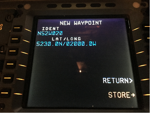
-
52 degrees-30 minutes North latitude, 20 degrees West longitude inserted into the FMC using full latitude and longitude degrees, minutes and seconds (i.e., 13 characters)
-
The waypoint IDENT is truncated to 7 characters with no display of minutes of latitude.
Figure 2 . Example Map Display: Full Waypoint Latitude and Longitude (13-characters) Inserted into FMC
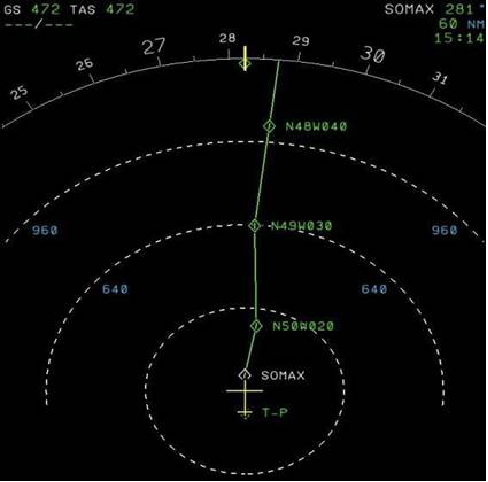
-
50 degrees-30 minutes North, 20 degrees West displayed is displayed in 7 characters. (N50W020)
-
Minutes of latitude are not displayed.
-
The Map display would be the same for 50 degrees North, 20 degrees West.
(Performance Based Flight Systems Branch, AFS-470, 10/7/16)
January 2017 Update - NAT ATS Surveillance Airspace
Phase 2 of the North Atlantic Regional Data Link Mandate
-
Introduction
-
Purpose of This Notice. This Notice provides notice to U.S. operators of the plan for Phase 2 of the North Atlantic Data Link Mandate (NAT DLM). The plan was adopted at the Forty−ninth meeting of the North Atlantic Systems Planning Group (NAT SPG/49). As detailed below, Phase 2 is planned to be implemented in three phases (2A, 2B and 2C). Phase 2A was implemented on 5 February 2015. Phase 2B is planned for 7 December 2017 and Phase 2C is planned for 30 January 2020. The Notice provides information on: the expanded vertical and horizontal boundaries of NAT DLM airspace and policies for planning operations into NAT DLM airspace.
-
January 2017 update. This Notice provides an update to the "ATS Surveillance Airspace Graphic". (See paragraph 10). It also provides guidance for operation of aircraft that are not data link equipped on "Tango" routes, when DLM Phase 2B is implemented on 7 December 2017. (See paragraph 4).
-
-
Background
-
NAT DLM Phase 2A. DLM Phase 2A commenced on 5 February 2015. As of that date, all aircraft operating between FL 350 to FL 390 (inclusive) on or at any point along in the NAT organized track system (OTS) during the OTS validity period are required to be fitted with and using FANS 1/A (or equivalent) CPDLC andADS-C equipment. (This phase applies to all aircraft operating on or at any point along the tracks).
Note: the "FAA NAT Resource Guide for U.S. Operators" provides information on NAT initiatives and programs, including this Notice. It can be accessed at:
http://www.faa.gov/about/office_org/headquarters_offices/avs/offices/afs/afs400/afs470/media/NAT.pdf
It is recommended that "Google Chrome" be used to access the site.
-
NAT DLM Phase 2B (7 December 2017). DLM Phase 2B will commence on 7 December 2017. On that date the NAT DLM will apply between FL 350−FL 390 (inclusive) throughout the ICAO NAT Region.
-
NAT DLM Objectives. The objectives of the NAT DLM are to enhance communication, surveillance and ATC intervention capabilities in the NAT Region in order to reduce collision risk and enable the NAT Target Level of Safety to be met, particularly in the vertical plane. ADS−C provides capabilities for conformance monitoring of aircraft adherence to cleared route and FL, thereby, significantly enhancing safety in the NAT Region. ADS−C also facilitates search and rescue operations and the capability to locate the site of an accident in oceanic airspace. CPDLC significantly enhances air/ground communication capability and, therefore, controller intervention capability.
-
NAT DLM Equipage Goals. The NAT SPG goals for the expansion of the NAT DLM are in concert with the ICAO Global Air Navigation Plan (GANP) (Doc 9750), Aviation System Block Upgrade (ASBU) Block 0, Module B0−40 (2013−2018). This module calls for safety and efficiency improvements for enroute operations supported by data link. The NAT SPG goals are that: by 2018, 90% of aircraft operating in the NAT Region airspace at FL290 and above will be equipped with FANS 1/A (or equivalent) ADS−C and CPDLC systems, and, that by 2020, 95% of aircraft operating in that airspace will be so equipped.
-
-
Planned Vertical and Horizontal Boundaries for NAT Region DLM Airspace
-
Phase 2A commenced 5 February 2015: FL350 to FL390 (inclusive) all tracks within the NAT Organized Track System (OTS). (This phase applies to all aircraft operating on or at any point along the tracks;
-
Phase 2B commencing 7 December 2017: FL350-FL390 (inclusive) throughout the ICAO NAT Region;
-
Phase 2C commencing 30 January 2020: FL290 and above throughout the ICAO NAT Region.
-
-
Airspace NOT INCLUDED in NAT Region DLM Airspace
-
ATS Surveillance Airspace. "ATS Surveillance Airspace" is airspace where surveillance is provided by radar, multilateration, and/or ADS−B and VHF voice communications are available. Aircraft must be suitably equipped with transponder/ADS−B Extended Squitter (ES) transmitter).
Note: for planning purposes, a depiction of ATS Surveillance Airspace, where flights are considered to be exempt from the DLM in the NAT Region is provided below in the "January 2017 Update: ATS Surveillance Airspace Graphic". See paragraph 10. ATS Surveillance Airspace is also depicted in State AIP’s.
-
Airspace north of 80 ° North. (Airspace north of 80°N lies outside the reliable service area of geostationary satellites).
-
The New York Oceanic FIR
-
Tango routes. When DLM Phase 2B commences on 7 December 2017, aircraft not data link equipped will be allowed to continue to operate on the routes specified below:
-
T9 and T213. Aircraft not data link equipped will be allowed to operate on T9 and T213 until solutions to provide ATS surveillance and VHF coverage on those routes are implemented. (When that coverage is provided, the NAT DLM would no longer be applicable to those routes. T213 will be moved to the east in order to provide ATS Surveillance and VHF coverage). ATS surveillance and VHF coverage will be provided on these routes as early as possible, but no later than 30 January 2020.
-
T16 (until 20 January 2020)
Note: aircraft operators using Tango routes within the NAT DLM area of applicability will either complete their fleet upgrades by January 2020 or will not be allowed to operate in DLM airspace.
-
-
-
Flights A llowed to Flight Plan into NAT Region Phase 2 DLM Airspace. The following flights will be permitted to flight plan to enter the NAT DML airspace:
-
Equipped Flights. Flights equipped with and prepared to operate FANS 1/A (or equivalent) CPDLC and ADS-C data link systems.
-
Specific Categories of Non- equipped Flights: Non-equipped flights that file STS/FFR, HOSP, HUM, MEDEVAC SAR, or STATE in Item 18 of the flight plan. (Depending on the tactical situation at the time of flight, however, such flights may not receive an ATC clearance which fully corresponds to the requested flight profile).
-
-
Operational Policies Applicable to NAT Region Phase 2 DLM Airspace
-
Climb or Descent of Non- equipped Aircraft. Any aircraft not equipped with FANS 1/A (or equivalent) systems may request a continuous climb or descent without intermediate level off through NAT DLM airspace. Such requests will be considered on a tactical basis.
-
Altitude Reservation (ALTRV) Requests. ALTRV requests will be considered on a case by case basis (as is done today regarding NAT MNPS airspace), irrespective of the equipage status of the participating aircraft.
-
FANS 1/A (or equivalent) Datalink System Failure Prior to Departure. If a flight experiences an equipment failure PRIOR TO DEPARTURE which renders the aircraft non-DLM compliant, the flight should flight plan so as to remain clear of NAT Regional DLM Airspace.
-
FANS 1/A (or equivalent) Datalink System Failure After Departure. If a flight experiences an equipment failure AFTER DEPARTURE which renders the aircraft unable to operate FANS 1/A (or equivalent) CPDLC and/or ADS-C systems, requests to operate in the NAT DLM Airspace will be considered on a tactical basis. Such flights must notify ATC of their status PRIOR TO ENTERING the airspace.
-
FANS 1/A (or equivalent) Datalink System Failure After Entering NAT DLM Airspace. If a FANS 1/A data link equipment failure occurs while the flight is OPERATING WITHIN NAT DLM AIRSPACE, ATC must be immediately advised. Such flights may be re-cleared so as to avoid the airspace, but consideration will be given to allowing the flight to remain in the airspace, based on tactical considerations.
-
-
European/North Atlantic (EUR/NAT) Interface Where the NAT interfaces with the EUR Data Link Implementation Rule airspace, procedures will be established by the ANSPs concerned to facilitate the vertical transition of traffic to and from the NAT Region Data Link Mandate and the EUR Data Link Implementation Rule areas. The transition will be conducted as soon as is practicable by the initial EUR Domestic area along the common FIR/UIR boundary bordering the NAT Region Data Link Mandate. For flights exiting the NAT Region DLM airspace, operators and the ANSP's shall ensure that the vertical transition is complete prior to crossing any subsequent FIR/UIR boundary.
-
U.S. Operator Requirement for Operational Authorization to Use FANS 1/A (or equivalent) Data Link Systems.
-
U.S operators are required to obtain operational authorization prior to using FANS 1/A data link systems. U.S. FAA guidance on the process and procedures for operational authorization and aircraft data link system approval can be found in the following documents:
-
AC 20-140 (as amended) (Guidelines for Design Approval of Aircraft Data Link Communication Systems Supporting Air Traffic Services (ATS)).
Note: The Inmarsat I3 and Inmarsat I4 Classic Aero sub-networks and Iridium Short Burst Data have been determined to be acceptable for data link services in the NAT Region.
-
AC 120-70 (as amended) (Operational Authorization Process for Use of Data Link Communication System)
-
-
These documents are posted on the "FAA NAT Resource Guide for U.S. Operators" under: COMM/Nav/Surveillance, Data Link Communications. See paragraph 2 above for access to the Resource Guide.
-
The U.S. FAA will grant operational authorization for operators to use FANS 1/A data link by issuing an Operational Specifications or Management Specifications paragraph A056 (Data Link Communications), as appropriate, or a part 91 Letter of Authorization A056 (Data Link Communications).
-
-
Contacts
Name
Organization
Phone
Email
Mark Wisniewski
SAIC, AFS-470 program support
202-863-8843
Mark Patterson
AFS-470
202-863-8848
Madison Walton
AFS-470
202-863-8850
-
January 2017 Update to NAT "ATS Surveillance Airspace Graphic". The "January 2017 Update: ATS Surveillance Airspace Graphic" updates the depiction of the airspace. ATS Surveillance Airspace is located in the green shaded areas shown in the graphic.
(Performance Based Flight Systems Branch, AFS-470, 1/31/17)
January 2017 Update: ATS Surveillance Airspace Graphic - NAT Regional Data Link Mandate Phase 2
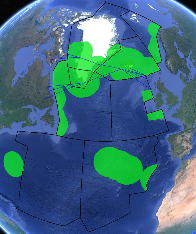
Note 1. ATS surveillance and VHF voice coverage is provided at and above FL 300 in the
green shaded areas.
Note 2. The blue lines on the map represent the NAT Blue Spruce Routes.
Operational Policy/Procedures for 30 Natuical Mile (NM) Lateral, 30 NM Longitudinal and 50 NM Longitudinal Separation in the Anchorage, oakland and New York Oceanic Control Areas (CTAs)
-
Applicability and Areas Affected (Date/Time and Area)
-
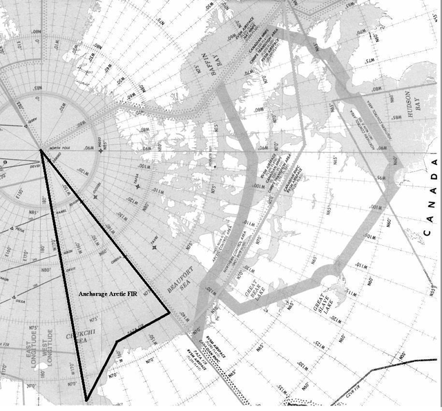
Applicability. The policies, guidance and procedures in this section apply to appropriately authorized and equipped aircraft operating throughout the Anchorage, Oakland and New York Oceanic Control Areas (CTAs), excluding the Anchorage Arctic FIR.
-
Date/Time. Since December 2005 Oakland Air Route Traffic Control Center (ARTCC), November 2012 Anchorage ARTCC and beginning in December 2013 New York ARTCC, have applied 30 NM lateral, 30 NM longitudinal and 50 NM longitudinal separation between suitably equipped and authorized pairs of aircraft throughout the respective CTAs/Flight Information Regions (FIRs). The ARTCCs continue to accommodate operators that are not eligible for the reduced separation minima. Published ATS routes and other tracks have not changed. Minimum separation based on ADS-C between aircraft authorized RNP 4 and aircraft authorized Required Navigation Performance 10 (RNP 10) will continue to be 50 NM lateral and 50 NM longitudinal. Lateral and longitudinal separation standards applied between RNP 10 and Non-RNP aircraft also remains unchanged.
-
-
Requirements for Aircraft and Operators
-
Communication, Navigation and Surveillance Requirements. The combination of RNP values, specified communication capability and necessary surveillance and the associated separation minimum are in table:
Separation Minimum
Navigation Requirement
Communication Requirement
ADSC Surveillance Requirements
50 NM longitudinal
RNP 10
CPDLC
Position report at least every 27 minutes (at least every 32 minutes if both aircraft are approved for RNP-4 operations)
30 NM longitudinal
RNP 4
CPDLC
ADS-C position report at least every 10 minutes (14 minutes in Oakland)
30 NM lateral
RNP 4
CPDLC
ADS-C-based lateral deviation event contract with 5NM lateral deviation from planned routing set as threshold for triggering ADS report of lateral deviation event
-
RNP Authorizations and Equipage. For reduced separation to be applied, the aircraft and operator must be authorized by the State of the operator or State of Registry, as appropriate, for the required RNP specification. The aircraft must be equipped with two approved long range navigation systems that will enable the aircraft to maintain the required navigation performance for the duration of flight in the applicable airspace. The aircraft must be equipped with a FANS-1/A package (or equivalent) that includes satellite CPDLC and ADS-C that meets the standards of RTCA DO 258 using ARINC 622 Data Communication Standard. CPDLC communications and ADS-C surveillance must be conducted in accordance with ICAO Global Operational Data Link Document (GOLD), as amended, and maintained for the duration of the flight in the applicable CTA. Pilots and, if applicable, dispatchers must be trained on policies and procedures for 30 NM lateral, 30 NM longitudinal and 50 NM longitudinal requirements including the use of satellite CPDLC and ADS-C in oceanic airspace. See the ICAO Document (Doc) 9613, Performance-based Navigation (PBN) Manual and Advisory Circular 90-105A Approval Guidance for RNP Operations and Barometric Vertical Navigation in the U.S. National Airspace System and in Oceanic and Remote Continental Airspace.
NOTE-
Currently RNP4 and RNP 10 are the only navigation specifications applicable to oceanic operations. However, RNP 2 is being developed and once implemented aircraft and operators authorized RNP 2 should be eligible for these reduced separation minima. -
Data Link Operational Authorization. U.S. operators are required to obtain operational authorization prior to using FANS 1/A data link systems. Data link authorizations should be in accordance with FAA AC 20-140 (as amended), Guidelines for Design Approval of Aircraft Data Link Communication Systems Supporting Air Traffic Services (ATS) and FAA AC 120-70 (as amended), Operational Authorization Process for Use of Data Link Communication System.
-
-
Flight Planning Requirements: To inform ATC, and to key Ocean21 automation, that aircraft operators have appropriate operational authorizations and are therefore eligible for 30 NM lateral, 30 NM longitudinal or 50 NM longitudinal separation, operators must annotate their flight plans in accordance with the following table:
Flight Plan Filing RequirementsItem 10a. Radio communication, navigation and approach aid equipment and capabilities:
-
CPDLC capabilities: J5 (CPDLC FANS 1/A SATCOM (INMARSAT)) and/or J7 (CPDLC FANS 1/A SATCOM(Iridium)), J6 (CPDLC FANS 1/A SATCOM (MTSAT, where applicable)
-
Navigation: R (PBN approved) (see related Item 18 entry below)
Item 10b. Surveillance equipment and capabilities:
-
D1 (ADSC with FANS 1/A capabilities)
Item 18. Other information:
-
PBN/L1 (RNP 4)
-
PBN/A1 (RNP 10)
NOTE- If only RNP 10 is filed then separation is limited to 50 NM.
-
-
Special Emphasis Items.
-
Weather Contingency Procedure. Weather deviation procedures can be found in ICAO Doc 4444, Procedures for Air Navigation Services - Air Traffic Management (PANS-ATM), Chapter 15.2.3. Pilots maneuver (deviate) around convective weather on a regular basis in the course of operations. Weather, therefore, was a major factor considered in establishing the ATC, operator and aircraft requirements for reducing horizontal separation minima to 30 NM. For weather avoidance maneuvers in areas where 30 NM lateral and 30 NM longitudinal separation minima are applied, operators must train the procedures in the ICAO Doc 4444. Emphasis should be placed on the following:
-
In accordance with ICAO Doc 4444, pilots are reminded that, regardless of the magnitude of a deviation from assigned route, whenever possible, clearance should be requested in advance from ATC. This does not apply to deviations associated with Strategic Lateral Offset Procedures (SLOP). Prior coordination with ATC will help prevent the aircraft generating unnecessary alerts to ATC for lateral deviation events.
-
Pilots should not assume that the Ocean21 system will quickly detect significant changes to the aircraft flight path. Unlike radar, the Ocean21 system does not receive aircraft position updates in real-time. Aircraft position is updated to the Ocean21 system at intervals of up to 10 minutes, when 30 NM lateral and 30 NM longitudinal separation is applied. Controllers can change the update intervals as the situation warrants.
-
It is therefore imperative that pilots keep ATC advised, via CPDLC (or HF voice, if necessary), of their intentions (including significant airspeed changes and/or turbulence conditions) during the initial weather avoidance maneuver and any subsequent maneuvers to avoid convective weather. In order to enhance situational awareness, flight crews should consider broadcasting on 123.45 or 121.5 their intentions to deviate from weather particularly if an ATC weather deviation is not obtained. This could be a significant event in reduced lateral separation situations.
-
Pilots must be aware that other aircraft could be approximately 30NM ahead or behind them on the same track and inform ATC expeditiously of changes to flight path or airspeed that could erode longitudinal separation.
-
In particular, for the weather deviation procedures, pilots should be aware of the provision to climb or descend 300 feet (depending on the direction of flight and direction of deviation from track) to mitigate the chance of conflict with other aircraft when forced to deviate without a clearance.
-
It is recommended that ACAS be operational for aircraft to which 30 NM lateral and 30 NM longitudinal separation minima can be applied. ACAS is not a separation maintenance tool, but provides valuable data to alert the pilot to the presence and proximity of nearby aircraft in contingency and weather deviation situations.
-
-
15NM Offset Contingency Procedures. Guidance published in ICAO Doc 4444, Chapter 15.2 reflects current ICAO guidance calling for a 15 NM track offset when unable to obtain ATC clearance prior to executing maneuvers for contingencies such as rapid descent, turn-back or diversion. This is of particular importance for aircraft to which 30 NM separation minima can be applied.
-
GOLD Procedures for Data Link Operations and Conditional Clearances. A conditional clearance is an ATC clearance given to an aircraft with certain conditions or restrictions such as changing a flight level based on a time or place. Conditional clearances add to the operational efficiency of the airspace. However, conditional clearances have been associated with a large number of pilot deviations. These types of clearances require special attention by the flight crew and operators should develop training material to emphasize proper procedures for executing them accordingly. Resources available for aircrew to properly interpret conditional clearances (and which may assist operators in developing training material) can be found in the ICAO Global Operational Data Link Document (GOLD), Chapter 5 and paragraph 5.3.3. Additionally, the North Atlantic Oceanic Error Safety Bulletin (OESB) provides operators information on procedures and best practices for dealing with conditional clearances. Both the GOLD and the latest version of the OESB can be found in the "NAT Resource Guide for US Operators". See the web link in paragraph 3.
-
Aircraft Navigation or Data Links System Malfunction. Pilots must advise ATC of any loss of CPDLC and/or ADS-C capability or an inability to continue to meet RNP-4. ATC will then apply the separation standard appropriate to the situation.
-
Air Traffic System Malfunction. If there is a known malfunction of the CPDLC or ADS-C ground system, ATC will contact aircraft and apply separation appropriate to the situation.
-
Verifying correct RNP Values prior to entering oceanic and remote airspace. RNP procedures and routes may require the use of RNAV systems with on−board performance monitoring and alerting. A critical component of RNP is the ability of the aircraft navigation system, in combination with the pilot, to monitor its achieved navigation performance and to identify for the pilot whether the operational requirement is, or is not, being met. Operators conducting oceanic operations must verify the RNP value is properly entered into the FMC, from the flight plan, prior to the aircraft entering oceanic or remote airspace.
-
Pilot Report of NonRNP10 or RNP 4 Status. If RNP 10 or RNP 4 approval status is requested by the air traffic controller, the pilot shall communicate approval status using the following phraseology:
RNP 10 or 4 Approval StatusController Request
Pilot Response
"(call sign) confirm RNP 10 or 4 approved"
" Affirm RNP 10 approved" or " Affirm RNP 4 approved", as appropriate, or
" Negative RNP 10"
-
Strategic Lateral Offset Procedures (SLOP). Pilots should use SLOP procedures in the course of regular oceanic operations. SLOP procedures are published in ICAO Doc 4444, paragraph 16.5 and. FAA
-
Monitoring Aircraft Navigation. The FAA will monitor and document aircraft navigation errors and system malfunctions. Operators are required to cooperate in follow up investigations of these events. Monitoring is used to verify separation safety and as a means to detect trends in operational practice.
-
-
Points of contact. If there are questions or requests, one of the following may be contacted:
|
Name |
Organization |
Phone |
|
|
Kim Joyce |
FAA Flight Standards Support, CSSI, Inc. |
+1 480-459-5786 |
|
|
Madison Walton |
FAA Flight Standards Service, AFS-470 |
+1 202-267-8850 |
|
|
Keith Dutch |
FAA Oceanic and Offshore Operations , North Pacific, AJV-824 |
+1 202-385-8459 |
|
|
Steven Pinkerton |
FAA Oceanic and Offshore Operations, North Atlantic, AJV-824 |
+1 202-385-8384 |
Special Notice -- NAT ATS Message Format
The following is submitted in an effort to standardize ATS message formats for air/ground communications in the North Atlantic (NAT) Region:
-
General
-
All NAT air−ground messages are categorized under one of the following headings (excluding emergency messages):
-
Position Request.
-
Request Clearance.
-
Revised Estimate.
-
Miscellaneous Message.
-
-
In order to enable ground stations to process messages in the shortest possible time, pilots should observe the following rules:
-
Use the correct type of message applicable to the data transmitted.
-
State the message type on the contact call to the ground station or at the start of the message.
-
Adhere strictly to the sequence of information for the type of message.
-
All times in each of the messages should be expressed in hours and minutes.
-
-
-
Description of ATS Message Types. Aircraft should transmit air−ground messages using standard RTF phraseology in accordance with the following:
-
POSITION. To be used for routine position reports
Content and Data Sequence
-
"POSITION."
-
Flight identification.
-
Present Position.
-
Time over present position (hours and minutes).
-
Present flight level.
-
Next on assigned route.
-
Estimated time for next position (hours and minutes).
-
Next subsequent position.
-
Any further information; e.g., MET data or Company message.
EXAMPLE−
"Position, SWISSAIR 100, 56N 010W 1235, flight level 330, estimating 56N 020W 1310, next 56N 030W"
-
-
REQUEST CLEARANCE
-
To be used, in conjunction with a routine position report, to request a change of mach number, flight level, or route and to request westbound oceanic clearance prior to entering Reykjavik, Santa Maria or Shanwick CTAs.
Content and Data Sequence
-
"REQUEST CLEARANCE."
-
Flight identification.
-
Present or last reported position.
-
Time over present or last reported position (hours and minutes).
-
Present flight level.
-
Next position on assigned route or oceanic entry point.
-
Estimate for next position or oceanic entry point.
-
Next subsequent position,
-
Requested Mach number, flight level or route.
-
Further information or clarifying remarks.
EXAMPLE−
"Request clearance, TWA 801, 56N 020W 1245, flight level 330, estimating 56N 030W 1320, next 56N 040W, requesting flight level 350"
-
-
To be used to request a change in Mach number, flight level, or route when a position report message is not appropriate.
Content and Data Sequence
-
"REQUEST CLEARANCE."
-
Flight identification.
-
Requested Mach number, flight level or route.
-
Further information or clarifying remarks.
EXAMPLE−
"Request clearance, BAW 212, requesting flight level 370"
-
-
-
REVISED ESTIMATE. To be used to update estimate for next position.
Content and Data Sequence
-
"Revised Estimate."
-
Flight Identification.
-
Next position on route.
-
Revised estimate for next position (hours and minutes).
-
Further information.
EXAMPLE−
"Revised estimate, WDA 523, 57N 040W 0325"
-
-
MISCELLANEOUS. To be used to pass information or make a request in plain language that does not conform with the content of other message formats. No message designator is required as this will be inserted by the ground station.
Content and Data Sequence
-
Flight identification.
-
General information or request in plain language and format free.
-
-
"When Able Higher" (WAH) Reports
To ensure maximum use of available altitudes, aircraft entering RVSM and/or NAT HLA airspace in the New York FIR should be prepared to advise ATC of the time or position the aircraft can accept the next higher altitude. WAH reports are also used to plan the altitude for aircraft as they transition from RVSM to CVSM altitudes. Therefore, it is important that the altitude capability of the aircraft is known by controllers. If the aircraft is capable of a higher altitude that, for whatever reason, is not preferred by the pilot, give the altitude in the WAH report and advise that you prefer not to be assigned that altitude.
The procedures will differ for eastbound and westbound aircraft since many of the eastbound aircraft will enter New York NAT HLA/RVSM airspace from ATC sectors that have direct controller-pilot communications. ATC acknowledgment of a WAH report is NOT a clearance to change altitude.
Eastbound aircraft entering RVSM or NAT HLA airspace in the New York FIR:
Pilots may be requested by ATC to provide an estimate for when the flight can accept the next higher altitude(s). If requested, pilots should provide this information as soon as possible.
Westbound aircraft entering RVSM or NAT HLA airspace in the New York FIR:
Pilots should include in the initial position report the time or location that the next higher altitude can be accepted.
EXAMPLE−
"Global Air 543, 40 north 40 west at 1010, flight level 350, estimating 40 north 50 west at 1110, 40 north 60 west.
Next able flight level 360 at 1035."
NOTE−
Pilots may include more than one altitude if that information is available.
EXAMPLE−
(after stating initial report) "Able flight level 360 at 1035, able flight level 370 at 1145, able flight level 390
at 1300."
Mandatory Pilot Reports
In addition to reading back altitude assignments, pilots shall report reaching any altitude assigned within RVSM airspace. This serves as a double check between pilots and controllers and reduces the possibility of operational errors. This requirement for altitude readback and reports of reaching assigned altitudes applies to both RVSM and CVSM altitudes (i.e., flight levels 330, 340, 350, 360, and 370).
EXAMPLE−
(initial altitude
readback
): "Global Air 543 climbing to flight level 360."
(upon reaching assigned altitude): "Global Air 543 level at flight level 360."
Caribbean, South America, and Gulf of Mexico
FDC 2/8646 ZFW TX.. Due to the lack of terrain and obstacle clearance data, accurate automation data bases are not available for providing minimum safe altitude warning information to aircraft overflying Mexico. Air traffic facilities along the United States/Mexico border have inhibited minimum safe altitude warning computer programs for aircraft operating in Mexican airspace until accurate terrain data can be obtained.
(ATP−130 7/29/02)
FDC 2/8645 ZHU TX.. Due to the lack of terrain and obstacle clearance data, accurate automation data bases are not available for providing minimum safe altitude warning information to aircraft overflying Mexico. Air traffic facilities along the United States/Mexico border have inhibited minimum safe altitude warning computer programs for aircraft operating in Mexican airspace until accurate terrain data can be obtained.
(ATP−130 7/29/02)
FDC 2/8644 ZAB NM.. Due to the lack of terrain and obstacle clearance data, accurate automation data bases are not available for providing minimum safe altitude warning information to aircraft overflying Mexico. Air traffic facilities along the united states/Mexico border have inhibited minimum safe altitude warning computer programs for aircraft operating in Mexican airspace until accurate terrain data can be obtained.
(ATP−130 7/29/02)
Special Notice -- Gulf of Mexico
Communication Requirements and Position Reporting Within Houston Oceanic Control Area
Position reports and the ability to communicate at any point of the route of flight is vital to the air traffic safety and control process. When flight planning, users are responsible to ensure that they will be capable of compliance. Inability to comply is in violation of ICAO requirements. The communication requirements for IFR flights within the Houston Oceanic Control Area are:
-
Functioning two-way radio communications equipment capable of communicating with at least one ground station from any point on the route.
-
Maintaining a continuous listening watch on the appropriate radio frequency.
-
Reporting of mandatory points.
The following describes an area in the Houston CTA/FIR where reliable VHF air-to-ground communications below FL180, are not available:
26 30 00N 86 00 00W TO 26 30 00N 92 00 00W
TO 24 30 00N 93 00 00W TO 24 30 00N 88 00 00W
TO 24 00 00N 86 00 00W TO BEGINNING POINT.
Communications within this area are available for all oceanic flights via HF.
The attention of pilots planning flights within the Houston CTA/FIR is directed to the communications and position reports requirements specified in the following ICAO Documents:
ANNEX 2, PARAGRAPHS 3.6.3 AND 3.6.5
ANNEX 11, PARAGRAPH 6.1.2
PANS−RAC 4444, PART 2, PARAGRAPH 14
DOC 7030, CAR, PARAGRAPH 3.
(FAA)
Gulf of Mexico RNAV Routes Q100, Q102, and Q105
This NOTAM defines RNAV equipment requirements for operators filing Q100, Q102, and Q105 through Gulf of Mexico airspace. Only aircraft approved for IFR Area Navigation operations will be cleared to operate on Q100, Q102, and Q105 between the surface and FL600 (inclusive).
Operator Determination of RNAV Equipment Eligibility
In addition, operators will not flight plan or operate on these routes unless their aircraft are equipped with RNAV systems that are approved for IFR navigation and the pilots are qualified to operate them. Aircraft may be considered eligible to operate on these routes if they fall under one of the following categories:
-
Reporting for new installations, the Airplane Flight Manual must show that the navigation system installation has received airworthiness approval in accordance with one of the following FAA ACs:
-
AC 20-138, as amended (Airworthiness Approval of Positioning and Navigation Systems).
-
AC 25-15 (Flight Management System [FMS] approval).
-
-
Installations that have previously received airworthiness approval under the following ACs are eligible for Gulf of Mexico Q-route operation provided it is shown in the Airplane Flight Manual:
-
AC 90-45A (RNAV system approval).
-
AC 20-130, as amended (Multi-Sensor Navigation system approval).
-
NOTE-
INS LIMITATIONS. See paragraph 6, below.
Operational Requirements and Procedures
-
Class I Navigation: operations on Q100, Q102 and Q105 will continue to be categorized as Class I navigation, as defined in FAA Order 8900.1, Vol. 4, Chapter 1, Section 3, Class I Navigation.
-
Operations Specifications: operators are considered eligible to conduct operations on the Q-routes provided that aircraft are equipped with the appropriate equipment in accordance with the "Operator Determination of RNAV Equipment Eligibility" paragraph above and operations are conducted in accordance with paragraph (3), (4), (5) and (6) below. Title 14 CFR Parts 121, 125, 135 operators are authorized to operate on the Q-routes when they are issued Operations Specifications (OpSpecs) paragraph B034 (Class I Navigation Using Area Navigation Systems). In addition, OpSpecs B034 must be annotated in OpSpecs paragraph B050 (Enroute Authorizations, Limitations and Procedures), for the Gulf of Mexico High Offshore Airspace.
-
Pilots in command filing on RNAV routes are certifying that the crews and equipment are qualified to conduct RNAV operations.
-
Pilots in command shall be responsible for navigating along route centerline (as defined by the aircraft navigation system) in accordance with the requirements of Title 14 CFR 91, section 181 (course to be flown) and ICAO Annex 2, paragraph 3.6.2.1.1. (Annex 2, paragraph 3.6.2.1 states that flights shall "in so far as practical, when on an established ATS route, operate on the defined centerline of that route.")
-
Pilots in command shall notify the Air Route Traffic Control Center (ARTCC) of any loss of navigation capability that affects the aircraft’s ability to navigate within the lateral limits of the route.
-
INS or IRS LIMITATION. For the purposes of operating on the following RNAV routes, Q100, Q102, and Q105, aircraft equipped with Inertial Navigation Systems (INS) or Inertial Reference Systems (IRS) that cannot receive automatic position updates (e.g., DME/DME update) for the entire length of the route, are limited to 1.5 consecutive hours of un-updated operation. In preparation for take-off, this time starts at the time that the INS or IRS is placed in the navigation mode. En route, the maximum time allowed between automatic position updates is 1.5 hours. Systems that perform updating after the pilot has manually selected the navigation aid are considered to have "automatic update" capability.
-
Radar monitoring will normally be provided. In the event of loss of radar, aircraft will be advised. ATC will ensure that the appropriate nonradar separation is applied during these time periods.
FAA Contacts
|
Name |
Organization |
Phone |
|
|
Madison Walton |
Performance Based Flight Systems Branch (AFS-470) |
202-267-8850 |
|
|
Jorge A. Chades |
Oceanic Air Traffic Procedures Group (AJV-824) |
202-385-8461 |
|
|
Jerry Bordeaux |
AJV-824 |
202-385-8329 |
(AFS-470, 4/29/14)
Miami CTA/FIR Havana CTA/FIR -- Miami CTA/FIR
Aircraft on IFR flight plans entering the Miami CTA/FIR from the Havana CTA/FIR are requested to establish communication with Miami Oceanic CTA/FIR on the frequencies listed below for airways/direct routes:
between 7810W - 7536W 127.22 VHF/239.02 UHF
between 7536W - 7320W 123.77 VHF/256.80 UHF
Aircraft must contact Miami ARTCC 10 minutes prior to reaching the Miami CTA/FIR Boundary.
NOTE−
This information should appear on all applicable Domestic and Latin American High/Low
En
Route Charts.
Radar Separation
Miami ARTCC and Havana Center. Aircraft predominantly use radar procedures. High altitude aircraft should anticipate radar services.
Miami ARTCC utilizes secondary radar systems from antennas located on the island of Grand Turk, Great Exuma Island and Nassau in the Bahamas. IFR aircraft within 200 NM of the antenna above FL130 can expect radar separation from other IFR aircraft. Radar service may be provided below FL130 by Miami Center to those participating aircraft within the antenna coverage.
Redundancy in radar coverage occurs above FL240, from the Tamiami radar antenna in South Florida, through the Bahamas and Turks & Caicos Island, to the radar systems in Puerto Rico.
There is no primary radar data or weather information available from the Grand Turk, Great Exuma and Nassau radar systems. Since radar separation is dependent upon the receipt of transponder returns, all aircraft within antenna coverage of either system are required to squawk transponder codes as assigned by ATC, or, if none assigned, squawk the appropriate stratum code.
Aircraft departing and overflying the Santo Domingo and Port Au Prince FIRs that will enter Miami ARTCC FIR can expect ATC assigned codes from those agencies. If a code is not assigned by either Santo Domingo or Port Au Prince, pilots should request a code. The assigned codes should be squawked prior to crossing the Miami CTA/FIR boundary north or west bound. Initial call up to Miami Center prior to crossing the CTA/FIR boundary will permit early radar identification. Radar flight following of VFR aircraft is available on a workload permitting basis. The primary ATC frequency is as follows: Grand Turk area 126.45 and 307.2 or secondary is 135.2 and 327.0; Great Exuma area 127.22 and 239.02 and Nassau are 125.7 and 307.9.
Aircraft on IFR flight plan entering Miami CTA/FIR from Port Au Prince or Santo Domingo CTA/FIR contact Miami ARTCC at least 10 minutes prior to reaching Miami CTA/FIR boundary.
(FAA)
Flight Planning Into or Through Miami CTA/FIR and San Juan CTA/FIRs
In an effort to eliminate erroneous or duplicate flight plans (FPLs) that may be received from various filers, and to increase the safety of flight within the Miami and San Juan CTA/FIRs, operators must adhere to the following procedures when filing flight plans for flights originating in foreign aerodromes and entering the United States National Airspace System:
-
All FPL amendments (CHG message) to an IFR flight must be submitted as soon as possible to the Air Traffic Service unit having authority for the departure aerodrome.
-
A Cancel (CNL) messages must be sent PRIOR to resubmitting a new FPL for the same flight.
These references are contained in ICAO DOC 4444 and FAAO 7210.3, Facility Operation and Administration. Operators should be aware that failure to adhere to these procedures could result in an operational delay or pilot deviation.
If you have any questions, please do not hesitate to call the Miami Center Flight Data at 1650/1731/1648.
(ZMA 8/1/13)
Special Notice -- Inspection of Means of Conveyance for Aircraft Moving to Guam
Inspection of aircraft moving to Guam. Any person who has moved an aircraft from Puerto Rico or the Virgin Islands of the United States to Guam shall contact an inspector and offer the inspector the opportunity to inspect the aircraft upon the aircraft’s arrival in Guam, unless the aircraft has been inspected and cleared in Puerto Rico or the Virgin Islands prior to departure in accordance with arrangements between the operator of the aircraft, the Animal and Plant Health Inspection Service, and the government of Guam.
(USDA Regulation 318.58-9)
50 NM Lateral Separation within Anchorage Arctic FIR
Policy and Procedures
Introduction. Throughout the Anchorage Arctic Flight Information Region (FIR) the FAA applies 50 nautical mile (NM) lateral separation between aircraft authorized to operate under Required Navigation Performance (RNP) 10 or 4 navigation specifications. This notice explains related policies and procedures pertaining to operations in the Anchorage Arctic FIR.
Separation Standards. Within the Anchorage Arctic FIR 50 NM lateral separation will be applied between any two aircraft for which flight plans indicate capability for RNP 10 or RNP 4. ATC will space any aircraft without RNP 10 or RNP 4 capability such that at least 90 NM lateral separation is maintained with other aircraft.
-
50 NM lateral separation is not provided on Northern Control Area tracks and laterals, nor on user preferred routes (UPR) unless restricted by NOTAM.
Accommodating non−RNP 10 aircraft. Operators intending to fly within the Anchorage Arctic FIR who are not authorized at least RNP 10 must include, in Item 18 of their flight plan, the annotation "RMK/NONRNP10." Operators of such aircraft may file for any route and altitude within the FIR. Clearance on preferred routes and altitudes will be provided as traffic allows for 90 NM lateral separation between that aircraft and any others. Priority will be given to RNP 10 or RNP 4 aircraft. Pilots of non−RNP 10 aircraft are to remind ATC of their RNP status, i.e. report "Negative RNP 10:"
-
Prior to entering Anchorage Arctic FIR
-
In reading back a clearance to descend from FL 410 within the Anchorage Arctic FIR
Note: Operators will likely benefit from the effort they invest to obtain RNP 10 or RNP 4 authorization, provided they are flying aircraft equipped to meet RNP 10 or RNP 4 standards.
Obtaining RNP 10 or RNP 4 operational authorization. For U.S. operators, Advisory Circular (AC) 90−105 provides the aircraft and operator qualification criteria for RNP 10 and RNP 4 authorizations. FAA personnel at certificate management offices and flight standards district offices will use the guidance contained on AC 90−105 to evaluate an operator’s application for RNP 10 or RNP 4 authorization. ICAO Document 9613 Performance Based Navigation (PBN) Manual establishes RNP authorization policies applicable to all ICAO member states. Operators can find "job aids" and other information that should help with the RNP authorization process on the FAA’s Pacific Resource Guide for U.S. Operators available at the following link:
Note: The operator's RNP 10 or RNP 4 authorization should include any equipment requirements (e.g. dual long-range navigation systems) and any RNP 10 time limits (if operating solely inertial-based navigation systems) that must be observed when conducting RNP operations. RNP 4 requires tighter navigation and track maintenance accuracy than RNP 10. RNP 4 requires use of GNSS.
Flight Plan Requirements. In order for an operator with RNP 10 or RNP 4 authorization to obtain 50 NM lateral separation within the Anchorage Arctic FIR, and therefore obtain routing available to RNP authorized aircraft, the flight plan must be annotated as follows:
-
Item 10a (Equipment) must include the letter "R"
-
Item 18 must include either "PBN/A1" for RNP 10 authorization or "PBN/L1" for RNP 4 authorization.
Indication of RNP 4 authorization implies the aircraft and pilots are also authorized RNP 10.
Note: The FAA's Aeronautical Information Manual (AIM), chapter 5, section 1, includes information on all flight plan codes.
Contingency procedures. Pilots operating under reduced lateral separation must be particularly familiar with, and prepared to rapidly implement, the standard contingency procedures specifically written for operations when outside ATC surveillance and direct VHF communications (e.g. the oceanic environment). Specific procedures have been developed for weather deviations. Operators should ensure all flight crews operating in this type of environment have been provided the standard contingency procedures in a readily accessible format. The margin for error when operating at reduced separation mandates correct and expeditious application of the standard contingency procedures. These standard, internationally accepted procedures are published in ICAO Document 4444, Procedures for Air Navigation Services - Air Traffic Management, chapter 15. The procedures are also provided in the U.S. Aeronautical Information Publication (AIP) section ENR 7.3, and the FAA’s AC 91−70 Oceanic and Remote Continental Airspace Operations.
Operators may find information and recommended procedures to follow in the event of degraded navigation capability in the FAA’s Chart Supplement Alaska, Notices section, under Navigation Procedures.
Strategic Lateral Offset Procedures (SLOP). Pilots should use SLOP in the course of regular operations within the Anchorage Arctic FIR. SLOP procedures and limitations are published in the Chart Supplement Alaska, the U.S. AIP, AC 91−70, and ICAO Document 4444.
Points of Contact. Operators may contact one of the following individuals to address questions specific to 50 NM lateral separation in the Anchorage Arctic FIR:
-
Beth Luciotti, AJV-84, 202-267-0619, Beth.L.Luciotti@faa.gov
-
Madison Walton, AFS-470, 202-267-8850, Madison.Walton@faa.gov
-
Mark Wisniewski, SAIC (supporting AFS-400), 202-267-8843, mark.ctr.wisniewski@faa.gov
(AJV-84 and AFS-470, revision 2/2/2017)
Artic 50 - Lateral Notice - Graphic