Cold Temperature Restricted Airports
Aug 17, 2017
Cold Temperature Altitude Corrections
Subject: Cold temperature altitude corrections at airports with a published cold temperature restriction.
Purpose: 1. To provide an updated list of 14 CFR Part 97 Cold Temperature Restricted Airports (CTRA) and segments designated with a temperature restriction; 2. Describe how to calculate and apply altitude corrections during cold temperature operations; 3. Describe the two methods, All Segments Methods and NTAP Segment(s) Method, which operators are allowed to use when making cold temperature altitude corrections.
This list may also be found at the bottom of the, "Terminal Procedures Basic Search" page. http://www.faa.gov/air_traffic/flight_info/aeronav/digital_products/dtpp/search/
Background: In response to aviation industry concerns over cold weather altimetry errors, the FAA conducted a risk analysis to determine if current 14 CFR Part 97 instrument approach procedures, in the United States National Airspace System, place aircraft at risk during cold temperature operations. This study applied the coldest recorded temperature at the given airports in the last five years and specifically determined if there was a probability that during these non-standard day operations, anticipated altitude errors in a barometric altimetry system could exceed the Required Obstacle Clearance (ROC) used on procedure segment altitudes. If a probability, of the ROC being exceeded, went above one percent on a segment of the approach, a temperature restriction was applied to that segment. In addition to the low probability that these procedures will be required, the probability of the ROC being exceeded precisely at an obstacle position is extremely low, providing an even greater safety margin.
The CTRA risk analysis was only performed on airports of 2500 ft. and greater due to database constraints. Pilots must calculate a cold temperature altitude correction at any airport included in the airports list below. Pilots operating into an airport with a runway length less than 2500 feet may make a cold temperature altitude correction in cold temperature conditions, if desired. Pilots must advise ATC with the corrected altitude when applying altitude corrections to any approach segment other than the final segment.
All Segments Method: Pilots may correct all altitudes from the IAF altitude to the missed approach final
holding altitude. Pilots familiar with the NTAP procedure for making altitude corrections and choosing to use the
All Segments Method are only required to use the published "snowflake" icon,
 /CTRA temperature limit on the approach chart for making corrections and do not need to reference the restricted
airports list in this NTAP. Calculations will be made based on the altitude at the Final Approach Fix (FAF)/Precision
Final Approach Fix (PFAF), the Minimum Descent Altitude or Decision Altitude (DA) and the Missed Approach (MA) final
holding altitude. The calculations made at these fixes will be used to make altitude corrections on the other fixes
in the applicable approach segment(s).
/CTRA temperature limit on the approach chart for making corrections and do not need to reference the restricted
airports list in this NTAP. Calculations will be made based on the altitude at the Final Approach Fix (FAF)/Precision
Final Approach Fix (PFAF), the Minimum Descent Altitude or Decision Altitude (DA) and the Missed Approach (MA) final
holding altitude. The calculations made at these fixes will be used to make altitude corrections on the other fixes
in the applicable approach segment(s).
NTAP Segment(s) Method: Pilots may correct only the required segment(s) indicated in this NTAP’s restricted airports list. Pilots using the NTAP Segment(s) Method will need to reference the NTAP restricted airports list to determine which segment(s) require a correction. Calculations will be made based on the altitude at the Final Approach Fix (FAF)/Precision Final Approach Fix (PFAF), the Minimum Descent Altitude or Decision Altitude (DA) and the Missed Approach (MA) final holding altitude. The calculations made at these fixes will be used to make altitude corrections on the other fixes in the applicable approach segment(s).
Actions:
When and where to correct: Pilots must make an altitude correction to the published, "at", "at or above" and "at or below" altitudes on all designated segment(s), for all published procedures and runways when the reported airport temperature is at or below the published airport cold temperature restriction on the approach plate. Pilots must advise ATC when correcting on any segment of the approach other than the final segment. Reference the How to Apply Cold Temperature Altitude Corrections on an Approach for examples and additional information.
Affected Airports: Cold Temperature Restricted Airports are identified by a "snowflake" icon (
) and temperature limit, in Celsius, on U.S. Government approach charts or a "textual" Note published on commercial
charting publications. The NTAP will maintain the list of airports and segment(s) affected. Pilots correcting all
segments will need only to use the instrument approach chart to determine whether the approach requires a cold temperature
altitude correction.
Altitudes not corrected: ATC will not apply a cold temperature correction to Minimum Vectoring Altitudes (MVA). Pilots must be cleared by ATC to apply a cold temperature compensation to an ATC assigned altitude or when flying on a radar vector in lieu of a published missed approach procedure. Pilots must not correct altitudes published on Standard Instrument Departures (SIDs), Obstacle Departure Procedures (ODPs) and Standard Terminal Arrivals (STARs).
Use of corrected MDA/DA: Pilots must use the corrected Minimum Descent Altitude (MDA) or Decision Altitude/ Decision Height (DA) as the minimum for an approach. Pilots must meet the requirements in 14 CFR Part 91.175 in order to operate below the corrected MDA or DA. Pilots must see and avoid obstacles when descending below the MDA.
Methods for Calculating Altitude Corrections: Pilots of aircraft not equipped with an RNAV system capable of temperature compensation must use the AIM 7-2-3, ICAO Cold Temperature Error Table to calculate a cold temperature altitude correction. The calculations for the approach will be calculated from three points on the approach:
NOTE: For the purpose of this procedure, when the FAF is referenced, it is the FAF altitude or the PFAF/Glideslope intercept altitude.
The FAF/PFAF will be used to calculate the correction to be applied to all altitudes from the FAF/PFAF:
Up to but not including the intermediate fix (IF) altitude for the NTAP Segment(s) Method
Up to and including the initial approach fix (IAF) for the All Segments Method
The published MDA or DA will be used to calculate the correction to be applied to all altitudes in the final approach segment as applicable.
The final missed approach (MA) holding altitude will be used to calculate the correction to be applied to the final missed approach holding altitude only.
NOTE: Pilots may use Real Time Mesocscale Analysis (RTMA): Alternate Report of Surface Temperature, for computing altitude corrections, when airport temperatures are not available via normal reporting. See InFO 15006 for additional information,
The RTMA website is http://nomads.ncep.noaa.gov/pub/data/nccf/com/rtma/prod/airport_temps/
Pilots of aircraft equipped with an RNAV system capable of temperature compensation, and choosing to use this system, must ensure the system is active and operating. If the system is not operating, or not being used, the pilot must manually calculate and apply a cold weather altitude correction using the AIM 7-2-3, ICAO Cold Temperature Error Table. The MDA/DA and step down fixes in the final segment will still require a manual correction.
PILOTS MUST NOT MAKE AN ALTIMETER CHANGE to accomplish an altitude correction. Pilots must ensure that the altimeter is set to the current altimeter setting provided by ATC in accordance with 14 CFR §91.121.
ICAO Cold Temperature Error Table
Height Above Airport in Feet

Acceptable Use of Table:
Pilots may calculate a correction with a visual interpolation of the chart when using reported temperature and height above airport. This calculated altitude correction may then be rounded to the nearest whole hundred or rounded up. I.e., a correction of 130 ft. from the chart may be rounded to 100 ft. or 200 ft. A correction of 280 ft. will be rounded up to 300 ft. This rounded correction will be added to the FAF, all step-down fixes outside of the FAF and the IAF altitudes. The correction calculated from the MDA or DA may be used as is, rounded up, but never rounded down. This number will be added to the MDA, DA and all step-down fixes inside of the FAF as applicable.
No extrapolation above the 5000 ft. column is required. Pilots may use the 5000 ft. "height above airport in feet" column for calculating corrections when the published altitude is greater than 5000 ft. above reporting station elevation. Pilots must add the correction(s) from the table to the affected segment altitude(s) and fly at the new corrected altitude.
It is important to understand that the correction from the table will place the aircraft back to an altitude based on a standard day. Although the techniques adopted in this NTAP to use the FAF altitude and MDA to correct the affected segment altitudes may not place the aircraft back to a standard day altitude on all fixes, a safe obstacle clearance will be maintained. These techniques have also been adopted to minimize the number of entries into the table while making corrections required by the pilot.
Additional Temperature Restrictions on IAP Charts: The charted temperature restriction for "uncompensated baro-VNAV systems" on 14 CFR Part 97 RNAV (GPS) and RNAV (RNP) Authorization Required (AR) approach plates is independent of the temperature restriction established at a "Cold Temperature Restricted Airport". The charted temperature restriction for an uncompensated baro−VNAV system is applicable when the LNAV/VNAV line of minima is used on an RNAV (GPS) approach. The temperature restriction for an uncompensated baro-VNAV system on an RNAV (RNP) AR approach applies to the entire procedure. Aircraft without a compensating baro-VNAV system may not use the LNAV/VNAV line of minima on the RNAV (GPS) approach when the actual temperature is above or below the charted \baro-VNAV temperature restriction. For aircraft without a compensating baro−VNAV system, the RNAV (RNP) AR approach is not authorized when the actual temperature is above or below the charted baro−VNAV temperature restriction. In all cases, a cold temperature altitude correction must be applied when the actual temperature is at or below the cold temperature restricted airport temperature restriction.
How to Apply Cold Temperature Altitude Corrections on an Approach:
NTAP Segment(s) method:
Step 1: Determine if there is a published "snowflake" icon,
/CTRA temperature limit on the approach chart.
Step 2: If the reported airport temperature is at or below the published CTRA temperature limit, apply cold temperature altitude corrections to all published altitudes, on the affected segments, listed in Cold Temperature Restricted Airports List found in this NTAP.
Aircraft not equipped with a temperature compensating RNAV system or not using the system will make a manual correction using ICAO Cold Temperature Error Table.
-
Intermediate Segment: All altitudes from the FAF/PFAF up to but not including the intermediate fix (IF) altitude. Calculate correction by taking FAF/PFAF altitude and subtracting the airport elevation. This number will be used to enter the height above airport in the ICAO table until reaching the reported temperature. Round this number as applicable and then add to FAF altitude and all step-down altitudes.
-
Final segment: Calculate correction by taking the MDA or DA for the approach being flown and subtract the airport elevation. This number will be used to enter the height above airport in the ICAO table until reaching the reported temperature. Use this number or round up. Add this number to MDA or DA/DH, as applicable, and any applicable step-down fixes in the final segment.
-
Missed Approach Segment: Calculate the correction by taking the final missed approach (MA) holding altitude and subtract the airport elevation. This number will be used to enter the height above airport in the ICAO table until reaching the reported temperature. Round this number as applicable and then add to the final MA altitude only.
If flying an aircraft equipped with a RNAV system capable of temperature compensation, follow the instructions for applying temperature compensation provided in the AFM, AFM supplement, or RNAV system operating manual. Ensure that temperature compensation is active on the segment being corrected. Manually calculate an altimetry correction for the MDA or DA. Determine an altimetry correction from the ICAO table based on the reported airport temperature and the height difference between the MDA or DA, as applicable, and the airport elevation.
NOTE: Some RNAV systems apply temperature compensation only to those altitudes associated with an instrument approach procedure loaded into the active flight plan while other systems apply temperature compensation to all procedure altitudes or user entered altitudes in the active flight plan, including altitudes associated with a STAR. For those systems that apply temperature compensation to all altitudes in the active flight plan, delay activating temperature compensation until the aircraft has passed the last altitude constraint associated with the active STAR.
Step 3: For RNAV (GPS) approaches flown to the LNAV/VNAV line of minima using baro-VNAV vertical guidance, determine if there are published uncompensated baro-VNAV temperature limits. If the reported airport temperature is above or below the published limits, do not use the LNAV/VNAV line of minima unless the RNAV system is capable of temperature compensation and the system is active. Use an alternative line of minima (e.g., LNAV). CTRA correction must still be made on this approach if applicable.
Step 4: For RNAV (RNP) AR approaches, determine if there are uncompensated baro-VNAV temperature limits published on the approach. If the reported airport temperature is above or below the published temperature limits, the RNP (AR) approach may not be flown.
NOTE: When executing an approach with vertical guidance at a CTRA airport (i.e., ILS, LPV, LNAV/VNAV), pilots are reminded to follow the glideslope/glidepath as published when it is intersected inbound on the approach at the corrected altitude. The ILS glideslope and WAAS generated glidepath are unaffected by cold temperatures and will be provide reliable vertical guidance to the corrected DA/DH. A baro-VNAV generated glidepath will be affected by cold temperatures and must be corrected when at or below the published temperature limit and using the LNAV/VNAV line of minima to DA/DH.
All Segments Method: All segments corrected from IAF through MA holding altitude:
Step 1: Determine if there is a published "snowflake" icon,
/CTRA temperature limit on the approach chart.
Step 2: If the reported airport temperature is at or below the published CTRA temperature limit, apply cold temperature altitude corrections to all published altitudes from the IAF altitude to the MA final holding altitude.
Aircraft not equipped with a temperature compensating RNAV system or not using that system (use manual correction).
-
All altitudes from the FAF/PFAF up to and including the IAF altitude: Calculate correction by taking FAF/PFAF altitude and subtracting the airport elevation. This number will be used to enter the height above airport in the ICAO table until reaching the reported temperature. Round this number as applicable and then add to all altitudes from the FAF altitude through the IAF altitude.
-
All altitudes in final segment: Calculate correction by taking the MDA or DA for the approach being flown and subtract the airport elevation. This number will be used to enter the height above airport in the ICAO table until reaching the reported temperature. Use this number or round up. Add this number to MDA or DA/DH, as applicable, and any applicable step-down fixes in the final segment.
-
Final holding altitude in the Missed Approach Segment: Calculate the correction by taking the final missed approach (MA) holding altitude and subtract the airport elevation. This number will be used to enter the height above airport in the ICAO table until reaching the reported temperature. Round this number as applicable and then add to the final MA altitude only.
If flying an aircraft equipped with a RNAV system capable of temperature compensation, follow the instructions for applying temperature compensation provided in the AFM, AFM supplement, or RNAV system operating manual. Ensure that temperature compensation is active prior to the IAF and remains active through the entire approach. Manually calculate an altimetry correction for the MDA or DA. Determine an altimetry correction from the ICAO table based on the reported airport temperature and the height difference between the MDA or DA, as applicable, and the airport elevation.
NOTE: Some RNAV systems apply temperature compensation only to those altitudes associated with an instrument approach procedure loaded into the active flight plan while other systems apply temperature compensation to all procedure altitudes or user entered altitudes in the active flight plan, including altitudes associated with a STAR. For those systems that apply temperature compensation to all altitudes in the active flight plan, delay activating temperature compensation until the aircraft has passed the last altitude constraint associated with the active STAR.
Step 3: For RNAV (GPS) approaches flown to the LNAV/VNAV line of minima using baro-VNAV vertical guidance, determine if there are published uncompensated baro-VNAV temperature limits. If the reported airport temperature is above or below the published limits, do not use the LNAV/VNAV line of minima unless the RNAV system is capable of temperature compensation and the system is active. Use an alternative line of minima (e.g., LNAV). CTRA correction must still be made on this approach if applicable.
Step 4: For RNAV (RNP) AR approaches, determine if there are uncompensated baro-VNAV temperature limits published on the approach. If the reported airport temperature is above or below the published temperature limits, the RNP (AR) approach may not be flown.
NOTE: When executing an approach with vertical guidance at a CTRA airport (i.e., ILS, LPV, LNAV/VNAV), pilots are reminded to follow the glideslope/glidepath as published when it is intersected inbound on the approach at the corrected altitude. The ILS glideslope and WAAS generated glidepath are unaffected by cold temperatures and will be provide reliable vertical guidance to the corrected DA/DH. A baro-VNAV generated glidepath will be affected by cold temperatures and must be corrected when at or below the published temperature limit and using the LNAV/VNAV line of minima to DA/DH .
Communication: Pilots must report cold temperature corrected altitudes to ATC whenever applying a cold temperature altitude correction. Pilots do not need to inform ATC of the final approach segment correction (i.e., new MDA or DA/DH). This report should be provided on initial radio contact with the ATC facility issuing approach clearance. ATC requires this information in order to ensure appropriate vertical separation between known traffic. Pilots should query ATC when vectored altitudes to a segment are lower than the requested corrected altitude. Pilots are encouraged to self-announce corrected altitude when flying into non-towered airfields.
The following are examples of appropriate pilot-to-ATC communication when applying cold-temperature altitude corrections.
-
On initial check-in with ATC providing approach clearance: Hayden, CO (example below).
-
Vectors to final approach course: Outside of PICIN: " Request 12 0 00 ft. for cold temperature operations ."
-
Vectors to final approach course: Inside of PICIN: " Request 10 5 00 ft. for cold temperature operations ."
-
Missed Approach segment: "Require final holding altitude, 10500 ft. on missed approach for cold temperature operations."
-
-
Pilots cleared by ATC for an instrument approach procedure; "Cleared the RNAV RWY 28 approach (from any IAF)". Hayden, CO (example below).
-
IAF: "Request 13500 for cold temperature operations at TUSKK, TILLI or HIPNA"
-
For additional information contact Kel Christianson, AFS-470, at 202-267-8838.
Cold Temperature Restricted Airports: Airports are listed by ICAO code, Airport Name, Temperature Restriction
in Celsius. The temperature will be indicated on Airport IAPs next to a snowflake symbol,
-XX°C in the United States Terminal Procedure Publication (TPP).
|
Identifier |
Airport Name |
Temperature |
Affected Segment |
||
|
|
|
|
Intermediate |
Final |
Missed Appr |
|
Alaska |
|
|
|
|
|
|
PABL |
Buckland |
-36C |
X |
|
|
|
PABR |
Wiley Post-Will Rogers |
-42C |
X |
|
|
|
PABT |
Bettles |
-37C |
X |
X |
|
|
PACE |
Central |
-25C |
X |
X |
|
|
PACH |
Chuathbaluk |
-36C |
X |
X |
|
|
PACI |
Chalkyitsik |
-32C |
X |
|
|
|
PACM |
Scammon Bay |
-21C |
X |
X |
X |
|
PACV |
Merle K (Mudhole) Smith |
-22C |
X |
|
|
|
PACX |
Coldfoot |
-11C |
X |
X |
X |
|
PADE |
Deering |
-24C |
X |
X |
|
|
PADM |
Marshall Don Hunter Sr |
-22C |
X |
X |
|
|
PAEE |
EEK |
-38C |
X |
|
|
|
PAEG |
Eagle |
-15C |
X |
|
|
|
PAEN |
Kenai |
-31C |
X |
|
|
|
PAFA |
Fairbanks Intl |
-20C |
X |
X |
X |
|
PAFM |
Ambler |
-42C |
X |
|
|
|
PAFS |
Nikolai |
-23C |
X |
|
|
|
PAGA |
Edward G. Pitka Sr |
-33C |
X |
|
X |
|
PAGH |
Shungnak |
-20C |
X |
|
X |
|
PAGK |
Gulkana |
-37C |
X |
|
|
|
PAGL |
Golovin |
-21C |
X |
|
X |
|
PAGM |
Gambell |
-26C |
|
X |
|
|
PAHC |
Holy Cross |
-26C |
X |
X |
|
|
PAHL |
Huslia |
-32C |
X |
|
|
|
PAHX |
Shageluk |
-37C |
X |
|
|
|
PAIK |
Bob Baker Memorial |
-7C |
X |
X |
|
|
PAIL |
Iliamna |
-13C |
X |
|
X |
|
PAIW |
Wales |
-12C |
X |
X |
|
|
PAJN |
Juneau Intl |
-13C |
X |
|
X |
|
PAKA |
Tatitlek |
-19C |
X |
|
|
|
PAKN |
King Salmon |
-31C |
X |
|
|
|
PAKP |
Anaktuvuk |
-9C |
X |
|
|
|
PAKT |
Ketchikan Intl |
-11C |
X |
|
|
|
PAKV |
Kaltag |
-21C |
X |
X |
|
|
PAKW |
Klawock |
-12C |
|
X |
|
|
PALG |
Kalskag |
-42C |
X |
|
|
|
PAMB |
Manokotak |
-34C |
X |
|
|
|
PAMC |
McGrath |
-31C |
X |
X |
X |
|
PAMH |
Minchumina |
-25C |
X |
X |
X |
|
PAMK |
St Michael |
-37C |
X |
|
|
|
PANA |
Napakiak |
-37C |
X |
|
|
|
PANI |
Aniak |
-30C |
X |
X |
|
|
PANN |
Nenana Muni |
-43C |
X |
|
|
|
PANO |
Nondalton |
-13C |
X |
|
|
|
PANU |
Nulato |
-29C |
X |
|
X |
|
PANV |
Anvik |
-32C |
X |
|
|
|
PAOB |
Kobuk |
-23C |
X |
|
|
|
PAOM |
Nome |
-27C |
X |
|
|
|
PAOR |
Northway |
-19C |
X |
|
|
|
PAOT |
Ralph Wien Memorial |
-44C |
X |
|
|
|
PAPG |
Petersburg James A Johnson |
-12C |
X |
|
X |
|
PAQH |
Quinhagak |
-17C |
X |
X |
X |
|
PAQT |
Nuiqsut |
-41C |
X |
|
|
|
PARC |
Artic Village |
-29C |
X |
X |
|
|
PARS |
Russian Mission |
-15C |
X |
X |
X |
|
PARY |
Ruby |
-33C |
X |
X |
|
|
PASA |
Savoonga |
-27C |
X |
|
|
|
PASC |
Deadhorse |
-45C |
X |
|
|
|
PASI |
Sitka Rocky Gutierrez |
-12C |
|
X |
|
|
PASK |
Selawik |
-36C |
X |
|
X |
|
PATA |
Ralph M Calhoun Memorial |
-32C |
X |
X |
|
|
PATE |
Teller |
-25C |
|
X |
|
|
PATQ |
Atqasuk Edward Burnell Sr. Mem |
-43C |
X |
|
|
|
PAUN |
Unalakleet |
-39C |
X |
|
|
|
PAVC |
King Cove |
-14C |
X |
|
|
|
PAVD |
Valdez Pioneer Field |
-4C |
X |
|
|
|
PAVE |
Venetie |
-42C |
X |
|
|
|
PAVL |
Kivalina |
-34C |
X |
|
|
|
PAWB |
Beaver |
-42C |
X |
|
|
|
PAWD |
Seward |
-3C |
X |
|
|
|
PAWG |
Wrangell |
-5C |
X |
X |
|
|
PAWI |
Wainwright |
-42C |
X |
|
|
|
PAWS |
Wasilla |
-31C |
X |
|
|
|
PFAL |
Allakaket |
-34C |
X |
|
X |
|
PFCL |
Clarks Point |
-34C |
X |
|
|
|
PFEL |
Elim |
-15C |
X |
X |
X |
|
PFKK |
Kokhanok |
-17C |
X |
|
X |
|
PFKT |
Brevig Mission |
-24C |
X |
X |
X |
|
PFKU |
Koyukuk |
-30C |
X |
X |
|
|
PFKW |
Kwethluk |
-38C |
X |
|
|
|
PFNO |
Robert (Bob) Curtis Memorial |
-17C |
X |
|
X |
|
PFSH |
Shaktoolik |
-25C |
X |
|
|
|
PFTO |
Tok Junction |
-20C |
X |
|
|
|
PFYU |
Fort Yukon |
-45C |
X |
X |
|
|
California |
|
|
|
|
|
|
KACV |
Arcata |
-5C |
X |
|
|
|
KBIH |
Eastern Sierra Rgnl |
-9C |
|
X |
|
|
KMMH |
Mammoth Yosemite |
-25C |
|
X |
|
|
KSVE |
Susanville Muni |
-19C |
X |
X |
|
|
KTRK |
Truckee - Tahoe |
-13C |
X |
X |
|
|
KTVL |
Lake Tahoe |
-27C |
X |
|
|
|
Colorado |
|
|
|
|
|
|
KAEJ |
Central Colorado Rgnl |
-25C |
|
X |
|
|
KANK |
Harriet Alexander Field |
-22C |
X |
|
|
|
KASE |
Aspen-Pitkin County/Sardy Field |
-22C |
X |
|
|
|
KCAG |
Craig-Moffat |
-26C |
X |
X |
|
|
KCEZ |
Cortez Muni |
-25C |
|
X |
|
|
KEEO |
Meeker Coulter Field |
-17C |
X |
X |
|
|
KEGE |
Eagle County Rgnl |
-18C |
X |
|
X |
|
KGUC |
Gunnison-Crested Butte Rgnl |
-24C |
X |
|
|
|
KHDN |
Yampa Valley |
-24C |
X |
X |
X |
|
KLXV |
Lake County |
-27C |
|
X |
|
|
KRIL |
Garfield County Rgnl |
-15C |
X |
X |
|
|
KSBS |
Steamboat Springs/Bob Adams Fld |
-32C |
X |
|
|
|
KTAD |
Perry Stokes |
-26C |
X |
|
|
|
KTEX |
Telluride Rgnl |
-14C |
|
X |
|
|
Connecticut |
|
|
|
|
|
|
KBDL |
Bradley Intl |
-23C |
|
X |
|
|
Idaho |
|
|
|
|
|
|
KDIJ |
Driggs-Reed Memorial |
-31C |
X |
|
|
|
KJER |
Jerome County |
-22C |
|
X |
|
|
KLWS |
Lewiston-Nez Perce County |
-17C |
X |
|
|
|
KMYL |
McCall Muni |
-21C |
X |
|
X |
|
KSMN |
Lemhi County |
-11C |
X |
|
|
|
KSUN |
Friedman Memorial |
-16C |
|
X |
|
|
65S |
Boundary County |
-8C |
|
X |
|
|
Indiana |
|
|
|
|
|
|
KSMD |
Smith Field |
-27C |
|
X |
|
|
Iowa |
|
|
|
|
|
|
KAMW |
Ames Muni |
-27C |
X |
|
|
|
KIKV |
Ankeny Rgnl |
-27C |
X |
|
|
|
KSPW |
Spencer Muni |
-32C |
X |
|
|
|
Maine |
|
|
|
|
|
|
KPQI |
Northern Maine Rgnl |
-30C |
X |
|
|
|
3B1 |
Greenville Muni |
-29C |
X |
|
|
|
Massachusetts |
|
|
|
|
|
|
KAQW |
Harriman-and-West |
-18C |
X |
|
|
|
KBAF |
Westfield-Barnes Regional |
-21C |
|
X |
|
|
KFIT |
Fitchburg Muni |
-25C |
X |
X |
|
|
KPSF |
Pittsfield Muni |
-24C |
|
X |
|
|
0B5 |
Turners Falls |
-22C |
X |
|
|
|
7B2 |
Northampton |
-24C |
X |
|
|
|
Michigan |
|
|
|
|
|
|
KAPN |
Alpena County Rgnl |
-32C |
X |
|
|
|
KBFA |
Boyne Mountain |
-29C |
|
X |
|
|
KIWD |
Gogebic-Iron County |
-27C |
|
X |
|
|
KPLN |
Pellston Rgnl of Emmet County |
-30C |
X |
X |
|
|
KTVC |
Cherry Capital |
-15C |
|
X |
|
|
Minnesota |
|
|
|
|
|
|
KBDE |
Baudette Intl |
-28C |
|
X |
|
|
KBFW |
Silver Bay Municipal |
-35C |
X |
X |
|
|
KCKC |
Grand Marais/Cook County |
-30C |
|
|
X |
|
KCQM |
Cook Muni |
-38C |
X |
|
|
|
KELO |
Ely Muni |
-39C |
X |
|
|
|
KHIB |
Range Rgnl |
-31C |
X |
|
|
|
KINL |
Falls Intl |
-31C |
X |
|
|
|
KRRT |
Warroad Intl Memorial |
-37C |
X |
|
|
|
Montana |
|
|
|
|
|
|
KBTM |
Bert Mooney |
-19C |
X |
X |
|
|
KBZN |
Bozeman Yellowstone Intl |
-12C |
X |
|
X |
|
KEKS |
Ennis-Big Sky |
-26C |
X |
|
X |
|
KGPI |
Glacier Park Intl |
-12C |
X |
|
X |
|
KGTF |
Great Falls Intl |
-33C |
X |
|
|
|
KHLN |
Helena Rgnl |
-16C |
X |
X |
X |
|
KHVR |
Havre City-County |
-30C |
|
|
X |
|
KMSO |
Missoula Intl |
-11C |
X |
X |
X |
|
KOLF |
L M Clayton |
-38C |
X |
|
|
|
KSBX |
Shelby |
-31C |
|
|
X |
|
KWYS |
Yellowstone |
-19C |
X |
X |
X |
|
M46 |
Colstrip |
-32C |
X |
|
|
|
M75 |
Malta |
-37C |
X |
|
|
|
S59 |
Libby |
-16C |
X |
|
X |
|
3U3 |
Bowman Field |
-33C |
X |
|
|
|
6S5 |
Ravalli County |
-23C |
|
|
X |
|
6S8 |
Laurel Municipal |
-30C |
X |
|
|
|
7S0 |
Ronan |
-27C |
X |
|
|
|
8S1 |
Polson |
-20C |
X |
X |
|
|
32S |
Stevensville |
-20C |
X |
|
|
|
Nebraska |
|
|
|
|
|
|
KCDR |
Chadron Muni |
-32C |
X |
|
|
|
Nevada |
|
|
|
|
|
|
KEKO |
Elko Rgnl |
-20C |
|
X |
|
|
KELY |
Ely (Yelland Field) |
-31C |
X |
|
|
|
KLOL |
Derby Field |
-25C |
X |
|
|
|
KRNO |
Reno/Tahoe Intl |
-15C |
|
X |
|
|
KRTS |
Reno/Stead |
-15C |
|
X |
|
|
KWMC |
Winnemucca Muni |
-22C |
|
|
X |
|
05U |
Eureka |
-24C |
|
|
X |
|
New Hampshire |
|
|
|
|
|
|
KBML |
Berlin Rgnl |
-24C |
X |
X |
|
|
KCNH |
Claremont Muni |
-28C |
|
X |
|
|
KHIE |
Mount Washington Rgnl |
-24C |
X |
X |
X |
|
KLCI |
Laconia Muni |
-25C |
X |
|
|
|
KLEB |
Lebanon Muni |
-20C |
X |
X |
|
|
2B3 |
Parlin Field |
-24C |
X |
|
|
|
5B9 |
Haverhill/Dean Memorial |
-27C |
|
X |
|
|
New Mexico |
|
|
|
|
|
|
KAXX |
Angel Fire |
-22C |
X |
|
|
|
New York |
|
|
|
|
|
|
KART |
Watertown Intl |
-37C |
X |
|
|
|
KDKK |
Chautauqua County/Dunkirk |
-20C |
X |
X |
|
|
KELM |
Elmira/Corning Rgnl |
-14C |
X |
X |
|
|
KGFL |
Floyd Bennett Memorial |
-18C |
X |
X |
|
|
KITH |
Ithaca Tompkins Rgnl |
-19C |
|
X |
|
|
KLKP |
Lake Placid |
-12C |
X |
X |
|
|
KPBG |
Plattsburgh Intl |
-29C |
X |
|
|
|
KSLK |
Adirondack Rgnl |
-26C |
|
X |
|
|
N89 |
Joseph Y Resnick |
-12C |
|
X |
X |
|
4B6 |
Ticonderoga Muni |
-27C |
|
X |
|
|
20N |
Kingston-Ulster |
-21C |
X |
|
|
|
North Carolina |
|
|
|
|
|
|
KRHP |
Western Carolina Rgnl |
-5C |
|
X |
|
|
1A5 |
Macon County |
-17C |
X |
|
|
|
North Dakota |
|
|
|
|
|
|
KBIS |
Bismarck |
-35C |
X |
|
|
|
KDIK |
Dickinson-Theodore Roosevelt Rgnl |
-30C |
X |
|
|
|
KFAR |
Hector Intl |
-25C |
X |
|
|
|
KISN |
Sloulin Field Intl |
-36C |
X |
|
|
|
Ohio |
|
|
|
|
|
|
KBKL |
Burke Lakefront |
-23C |
|
X |
|
|
KILN |
Wilmington Air Park |
-22C |
X |
|
|
|
Oregon |
|
|
|
|
|
|
KBDN |
Bend Muni |
-23C |
X |
|
|
|
KBKE |
Baker City Muni |
-21C |
X |
|
X |
|
KGCD |
Grant County Rgnl/Ogilvie Field |
-19C |
|
|
X |
|
KLGD |
La Grande/Union County |
-13C |
|
X |
|
|
KLKV |
Lake County |
-29C |
|
|
X |
|
KLMT |
Klamath Falls |
-27C |
X |
|
|
|
KMFR |
Rogue Valley Intl-Medford |
-5C |
X |
X |
|
|
KPDT |
Eastern Oregon Rgnl at Pendleton |
-19C |
X |
|
|
|
KRDM |
Roberts Field |
-21C |
X |
|
|
|
S39 |
Prineville |
-26C |
X |
|
|
|
3S8 |
Grants Pass |
-15C |
X |
|
|
|
Pennsylvania |
|
|
|
|
|
|
KAFJ |
Washington County |
-27C |
|
X |
|
|
KAVP |
Wilkes-Barre/Scranton Intl |
-21C |
X |
|
|
|
KIPT |
Williamsport Rgnl |
-14C |
X |
|
|
|
KMDT |
Harrisburg Intl |
-17C |
|
X |
|
|
South Dakota |
|
|
|
|
|
|
KEFC |
Belle Fourche Muni |
-27C |
X |
|
|
|
KIEN |
Pine Ridge |
-33C |
|
X |
|
|
KMBG |
Mobridge Muni |
-31C |
X |
|
|
|
KSPF |
Black Hills-Clyde Ice Field |
-28C |
X |
|
|
|
Tennessee |
|
|
|
|
|
|
0A9 |
Elizabethton Muni |
-12C |
|
X |
|
|
6A4 |
Mountain City/Johnson County |
-13C |
|
X |
|
|
Utah |
|
|
|
|
|
|
KBCE |
Bryce Canyon Airport |
-30C |
X |
|
|
|
KDTA |
Delta Muni |
-27C |
|
|
X |
|
KENV |
Wendover |
-12C |
X |
|
|
|
KLGU |
Logan-Cache |
-25C |
X |
|
|
|
KRIF |
Richfield Muni |
-28C |
X |
|
X |
|
KSGU |
St George Muni |
-14C |
X |
X |
|
|
U52 |
Beaver Municipal |
-27C |
X |
|
|
|
U55 |
Panguitch Municipal |
-28C |
X |
|
|
|
Vermont |
|
|
|
|
|
|
KBTV |
Burlington Intl |
-10C |
X |
X |
|
|
KDDH |
William H. Morse State |
-17C |
X |
X |
|
|
KEFK |
Newport State |
-30C |
X |
|
|
|
KMPV |
Edward F. Knapp State |
-20C |
X |
|
|
|
KMVL |
Morrisville-Stowe State |
-15C |
X |
X |
X |
|
KRUT |
Rutland-Southern Vermont Rgnl |
-4C |
X |
X |
|
|
KVSF |
Hartness State (Springfield) |
-24C |
X |
X |
|
|
Virginia |
|
|
|
|
|
|
KMTV |
Blue Ridge |
-18C |
X |
|
|
|
KROA |
Roanoke Rgnl/Woodrum Field |
-9C |
|
X |
|
|
KVBW |
Bridgewater Air Park |
-16C |
X |
|
|
|
W13 |
Eagle’s Nest |
-19C |
X |
|
|
|
Washington St. |
|
|
|
|
|
|
KEAT |
Pangborn Memorial |
-11C |
X |
|
|
|
KELN |
Bowers Field |
-17C |
X |
|
|
|
KOMK |
Omak |
-13C |
|
X |
|
|
KRLD |
Richland |
-19C |
X |
|
|
|
West Virginia |
|
|
|
|
|
|
KEKN |
Elkins-Randolph County Jennings Randolph Field |
-10C |
X |
X |
|
|
W99 |
Grant County |
-9C |
X |
X |
|
|
3I2 |
Point Pleasant/Mason County |
-21C |
|
X |
|
|
Wisconsin |
|
|
|
|
|
|
KASX |
John F. Kennedy Memorial |
-31C |
X |
|
|
|
KCMY |
Sparta/Fort McCoy |
-33C |
X |
|
|
|
KLNR |
Tri-County Rgnl |
-26C |
|
X |
|
|
KLSE |
La Crosse Muni |
-20C |
|
X |
|
|
KOVS |
Boscobel |
-27C |
|
X |
|
|
KPDC |
Prairie du Chien Muni |
-28C |
|
X |
|
|
KRHI |
Rhinelander-Oneida County |
-31C |
X |
|
|
|
KRPD |
Rice Lake Rgnl-Carl's Field |
-35C |
X |
|
|
|
4R5 |
Major Gilbert Field |
-30C |
X |
|
|
|
Wyoming |
|
|
|
|
|
|
KAFO |
Afton Municipal Airport |
-22C |
X |
X |
|
|
KCOD |
Yellowstone Rgnl |
-31C |
X |
|
|
|
KEMM |
Kemmerer Muni |
-35C |
X |
|
|
|
KGCC |
Gillette-Campbell County |
-26C |
|
X |
|
|
KGEY |
South Big Horn County |
-33C |
X |
X |
|
|
KJAC |
Jackson Hole |
-26C |
X |
X |
X |
|
KLAR |
Laramie Rgnl |
-35C |
X |
|
|
|
KSHR |
Sheridan County |
-24C |
X |
|
|
|
KWRL |
Worland Muni |
-33C |
|
|
X |
|
W43 |
Hulett Muni |
-34C |
X |
|
|
Additional Information: The following military airfields meet the criteria to be identified as a Cold Temperature Restricted Airport using the FAA cold temperature model. USAF, USA, USM, USN and USCG are not required to adhere to the procedures found in this NTAP at these airfields. This information is applicable to FAA authorized operators operating into these airfields.
|
Identifier |
Airport Name |
Temperature |
Intermediate |
Final |
Missed Appr |
|
KGTB |
Wheeler-Sack AAF |
-29C |
X |
|
|
|
KRYM |
Ray S. Miller AAF |
-34C |
X |
|
|
|
PAEI |
Eielson AFB |
-37C |
X |
|
X |
|
PAFB |
Ladd AAF |
-33C |
X |
|
X |
|
PAIM |
Indian Mountain LRRS |
-44C |
X |
|
|
|
PALU |
Cape Lisburne LRRS |
-34C |
X |
|
|
|
PASV |
Sparrevohn LRRS |
-21C |
X |
|
|
|
PATC |
Tin City LRRS |
-37C |
X |
|
|
|
PATL |
Tatalina LRRS |
-21C |
X |
|
X |
|
PPIZ |
Point Lay LRRS |
-41C |
X |
|
|
See the following examples for identifying and applying altitude corrections.
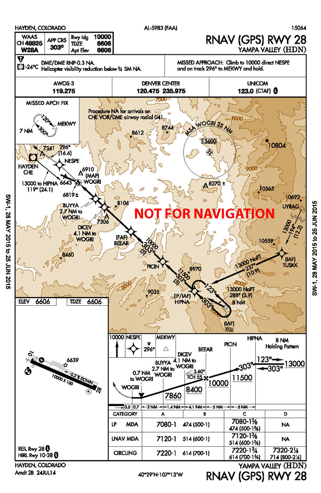
Hayden/Yampa Valley (KHDN). Reported Temperature -24° C: RNAV (GPS) RWY 28.
NTAP Segment(s) method: Intermediate, final and missed approach required.
Uncompensated Baro -VNAV System or Manual Method:
Cold Temperature Restricted Airport Temperature Limit: -24° C
Altitude at the Final Approach Fix (FAF) (BEEAR) = 10000 ft.
Airport elevation = 6606 ft.
Difference: 10000 ft. - 6606 ft. = 3394 ft.
Use the AIM 7-2-3 ICAO Cold Temperature Error Table for a height above airport of 3394 ft. and -24° C. Visual interpolation is approximately 500 ft. Actual interpolation is 546 ft. Add 500 ft. to the FAF altitude and all applicable altitudes outside of the FAF up to but not including IF altitude:
-
BEEAR (FAF): 10000 + 500 = 10500 ft.
-
PICIN (stepdown fix): 11500 + 500 = 12000 ft.
Correct altitudes within the final segment altitude based on the minima used, which is the LP MDA = 7080 ft.
Difference: 7080 ft. - 6606 ft. = 474 ft.
AIM 7-2-3 Table: 474 ft. at -24C is approximately 80ft. Use 80 ft. or round up to 100 ft.
Add corrections to altitudes up to but not including the FAF:
-
DICEV (stepdown fix): 8400 + 80 = 8480 ft.
-
BUYYA (stepdown fix): 7860 + 80 = 7940 ft.
-
LP MDA: 7080 + 80 = 7160 ft.
Correct MEKWY/Missed Approach Holding Altitude: MA altitude is same as BEEAR (10000); therefore, the same table calculation in step 5 may be used at MEKWY. Take 500 ft. correction for 10000 ft. and add to MA holding altitude:
-
MEKWY: 10000 + 500 = 10500 ft.
Compensated Baro -VNAV System:
Operators using a temperature compensating RNAV system to make altitude corrections will set the current airport temperature (-24° C) and activate the system for the required segment(s). A manual calculation of the cold temperature altitude correction is required for the MDA/DA. Although using the temperature compensating system should provide clearance over step-down fixes on any segment, a correction will be added to all applicable step-down fixes and monitored during descent to ensure aircraft will be "at" or "above" the corrected step-down fix altitude during the approach.
All Segments Method: All segments corrected from IAF through MA holding altitude:
Uncompensated Baro -VNAV System or Manual Method:
Cold Temperature Restricted Airport Temperature Limit: -24° C
Altitude at the Final Approach Fix (FAF) (BEEAR) = 10000 ft.
Airport elevation = 6606 ft.
Difference: 10000 - 6606 = 3394 ft.
Use the AIM 7-2-3 ICAO Cold Temperature Error Table for a height above airport of 3394 ft. and -24° C. Visual interpolation is approximately 500 ft. Actual interpolation is 546 Add 500 ft. to the FAF altitude and all applicable altitudes outside of the FAF up to and including IAF altitude:
-
BEEAR (FAF): 10000 + 500 = 10500 ft.
-
PICIN (Stepdown fix): 11500 + 500 = 12000 ft.
-
HIPNA (IF/IAF), TILLI (IAF) and TUSKK (IAF): 13000 + 500 = 13500 ft.
Correct altitudes within the final segment altitude based on the minima used, which is the LP MDA = 7080 ft.
Difference: 7080 - 6606 = 474 ft.
AIM 7-2-3 Table: 474 ft. at -24C is approximately 80ft. Use 80 ft. or round up to 100 ft.
Add corrections to MDA and all stepdown fix altitudes in final segment up to but not including the FAF:
-
DICEV (stepdown fix): 8400 + 80 = 8480 ft.
-
BUYYA (stepdown fix): 7860 + 80 = 7940 ft.
-
LP MDA: 7080 + 80 = 7160
Correct MEKWY/Missed Approach Holding Altitude: MA altitude is same as BEEAR (10000); therefore, the same table calculation in step 5 may be used at MEKWY. Take 500 ft. correction for 10000 ft. and add to MA holding altitude:
-
MEKWY: 10000 + 500 = 10500 ft.
Compensated Baro -VNAV System:
Operators using a temperature compensating RNAV system to make altitude corrections will be set to the current airport temperature (-24° C) and activated prior to the passing the IAF. A manual calculation of the cold temperature altitude correction is required for the MDA/DA. Although using the temperature compensating system should provide clearance over step-down fixes on any segment, a correction will be added to all applicable step-down fixes and monitored during descent to ensure aircraft will be "at" or "above" the corrected step-down fix altitude during the approach.
Arcata (KACV). Reported Temperature -5° C: RNAV (GPS) RWY 1.
NTAP Segment(s) method : Intermediate segment required
Uncompensated Baro -VNAV System or Manual Method:
-
Cold Temperature Restricted Airport Temperature Limit: -5° C
-
Altitude at the PFAF = 1900 ft.
-
Airport elevation = 222 ft.
-
Difference: 1900 ft. - 222 ft. = 1678 ft.
-
Use the AIM 7-2-3 ICAO Cold Temperature Error Table for a height above airport of 1678 ft. and -5° C. The approximate calculation is 130 ft. This may be rounded down to 100 ft. or rounded up to 200 ft. Add the correction to the FAF and all procedure altitudes outside of the FAF up to but not including IF:
-
OGMOW (PFAF): 1900 + 100 = 2000 ft.
If the airport temperature decreases below -15° C, an uncompensated baro-VNAV system may not be used to fly this approach to the LNAV/VNAV line of minima. Pilots of aircraft without a temperature compensated baro-VNAV system should select a different line of minima appropriate to capabilities of their RNAV system (e.g. LNAV line of minima). Cold temperature correction is still required on the intermediate segment.
Compensated Baro -VNAV System:
Operators using a temperature compensating RNAV system to make altitude corrections will set the current airport temperature (-5° C) and activate the system for the intermediate segment. At temperatures below -15° C, baro-VNAV temperature compensation must be on and active to use the LNAV/VNAV line of minima if baro-VNAV is used to generate the glidepath. Manual calculation of a cold temperature compensated MDA or DA, as applicable, is still required. Cold temperature correction is still required on the intermediate segment.
All Segments Method: All segments corrected from IAF through MA holding altitude:
Uncompensated Baro -VNAV System or Manual Method:
Cold Temperature Restricted Airport Temperature Limit: -5° C
Altitude at the Precise Final Approach Fix (PFAF) (OGMOW) = 1900 ft.
Airport elevation = 222 ft.
Difference: 1900 ft. - 222 ft. = 1678 ft.
Use the AIM 7-2-3 ICAO Cold Temperature Error Table for a height above airport of 1678 ft. and -5° C. The approximate calculation is 130 ft. This may be rounded down to 100 ft. or rounded up to 200 ft. Add the correction to the FAF and all procedure altitudes outside of the FAF up to and including IAF altitude:
-
OGMOW (PFAF): 1900 + 100 = 2000 ft.
-
SEGVE (IF/IAF) & Hold-in-Lieu of PT: 3000 + 100 = 3100 ft.
Correct altitudes within the final segment altitude based on the minima used, which is the LNAV/VNAV DA(H) = 847 ft.
Difference: 847 ft. - 222 ft. = 625 ft.
AIM 7-2-3 Table: 625 ft. at -5C is approximately 50 ft. Use 50 ft. or round up to 100 ft. for correction.
-
Add correction to LNAV/VNAV DA: 847 ft. + 50 ft. = 897 ft.
Correction at CULDU: Take final holding altitude and subtract field elevation: 3200 - 222 = 2978. Using table, correction is approximately 230 ft. This may be rounded down to 200 ft. or up to 300 ft.
-
Missed Approach Holding Altitude/CULDU: 3200 + 200 = 3400 ft.
If the airport temperature decreases below -15° C, an uncompensated baro-VNAV system may not be used to fly this approach to the LNAV/VNAV line of minima. Pilots of aircraft without a temperature compensated baro-VNAV system should select a different line of minima appropriate to capabilities of their RNAV system (e.g. LNAV line of minima). Manual calculation of a cold temperature compensated LNAV MDA, as applicable, is still required. Cold temperature correction is still required on all segments.
Compensated Baro -VNAV System:
Operators using a temperature compensating RNAV system to make altitude corrections will be set to the current airport temperature (-5° C) and activated prior to the passing the IAF. A manual calculation of the cold temperature altitude correction is required for the MDA/DA. At temperatures below -15° C, baro-VNAV temperature compensation must be on and active to use the LNAV/VNAV line of minima if baro-VNAV is used to generate the glidepath. Manual calculation of a cold temperature compensated MDA or DA, as applicable, is still required. Cold temperature correction is still required on all segments.

Arcata (KACV). Reported Temperature -5° C: ILS Y or LOC/DME RWY 32.
NTAP Segment(s) method : Intermediate segment required
Uncompensated Baro -VNAV System or Manual Method:
-
Cold Temperature Restricted Airport Temperature Limit: -5° C
-
Altitude at the PFAF = 2100 ft.
-
Airport elevation = 222 ft.
-
Difference: 2100 ft. - 222 ft. = 1878 ft.
-
Use the AIM 7-2-3 ICAO Cold Temperature Error Table for a height above airport of 1878 ft. and -5° C. The approximate calculation is 150 ft. Round up to 200 ft. Add the correction to the FAF and all procedure altitudes outside of the FAF up to but not including IF:
-
ELVAA (PFAF): 2100 + 200 = 2300 ft.
-
OMBEE (stepdown fix): 2800 + 200 = 3000 ft.
-
HURDU (stepdown fix): 3400 + 200 = 3600 ft.
Compensated Baro -VNAV System:
Operators using a temperature compensating RNAV system to make altitude corrections will set the current airport temperature (-5° C) and activate the system for the intermediate segment.
All Segments Method: All segments corrected from IAF through MA holding altitude:
Uncompensated Baro -VNAV System or Manual Method:
Cold Temperature Restricted Airport Temperature Limit: -5° C
Altitude correction at PFAF (ELVAA) = 200 ft.
Add the correction to the FAF and all procedure altitudes outside of the FAF up to and including IAF altitudes:
-
ELVAA (PFAF): 2100 + 200 = 2300 ft.
-
OMBEE (stepdown fix): 2800 + 200 = 3000 ft.
-
HURDU (stepdown fix): 3400 + 200 = 3600 ft.
-
KORBE (IF): 4300 + 200 = 4500 ft.
-
VOMAC (IAF): 6000 + 200 = 6200 ft.
-
FORTUNA (FOT) (IAF): 4300 + 200 = 4500 ft.
-
HIDAK (IAF): 5400 + 200 = 5600 ft.
Correct altitudes in the final segment based on the minima used. ILS DA(H): 421 ft.
Difference: 421 ft. - 222 ft. = 199 ft.
AIM 7-2-3 Table: 199 ft. at -5C is 20 ft. Use 20 ft. for correction or round up to 100 ft.
Add correction to DA: 421 + 20 = 441 ft.
Correction at final holing altitude (TRIAL): Take final holding altitude and subtract field elevation: 3000 - 222 = 2778. Using table, correction is approximately 210 ft. This may be rounded down to 200 ft. or up to 300 ft.
-
Missed Approach final holding altitude (TRIAL): 3000 + 200 = 3200 ft
Compensated Baro -VNAV System:
Operators using a temperature compensating RNAV system to make altitude corrections will be set to the current airport temperature (-5° C) and activated prior to the passing the IAF. A manual calculation of the cold temperature altitude correction is required for the MDA/DA.

(AFS-400, 8/17/2017)