Implementation of Instrument Flight Rules (IFR) Area Navigation (RNAV) Operations Using Global Positioning Systems (GPS) in Alaska
When. May 15, 2003
Type. Permanent
Purpose.
To enable, in Alaska, the use of Global Positioning System/Wide Area Augmentation Systems (GPS/WAAS) for IFR RNAV in lieu of ground-based navigation aids, including altitudes below current IFR Minimum Enroute Altitudes (MEAs). In general, IFR enroute altitudes are determined by (1) obstacle clearance; (2) the lowest altitude for receiving ground-based radio navigation signals; and (3) the lowest altitude for two-way voice communication with Air Traffic Control (ATC). No accommodation was made for IFR altitudes determined by fixes using other than ground-based navigation aids. Under SFAR No. 97, operators using IFR certified TSO C145a and TSO C146a GPS WAAS RNAV systems are permitted to conduct operations over routes in Alaska at the lowest MEA based only on route obstacle assessments and ATC two−way voice communication capability.
Operations.
SFAR No. 97 allows the use of IFR-certified RNAV GPS/WAAS systems in lieu of ground facilities. This SFAR can be used for U.S. and foreign Part 91 operations, as well as Part 119 operations, Part 125 certificate holders, and Part 129 operations specifications holders, commercial, and certificated air carrier operators, in Alaska. The SFAR establishes training requirements for operators, including service degradation and equipment failure modes. It allows operators subject to this SFAR to operate over Air Traffic Service (ATS) routes where the MEA for a route or route segment is lower for GPS/WAAS IFR RNAV-equipped aircraft than the MEA for operators equipped only with ground-based navigation systems. This flexibility allows those GPS/WAAS IFR RNAV-equipped operators to conduct operations at the lowest permissible altitude in an attempt to avoid in-flight icing or other adverse weather conditions.
Required equipment.
TSO C145a and TSO C146a GPS WAAS navigation systems are authorized to be used as the only means of navigation on Federal airways and other published ATS routes in lieu of ground-based navigation aids in Alaska. In the absence of a WAAS signal, these systems continue to provide navigation guidance using fault detection and exclusion (FDE) or receiver autonomous integrity monitoring (RAIM) techniques. Commercial operators are required to have dual TSO C145a or TSO C146a GPS WAAS navigation equipment, while Part 91 operations require at least one.
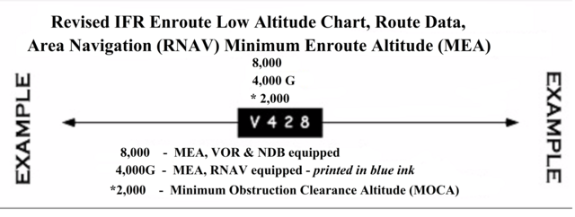
New chart features/symbology.
The new RNAV MEAs will be depicted on the Low Altitude Enroute Charts as in the example at the top of this notice. Without a Special (RNAV) MEA depicted, the Standard MEA will be used.
Chart terminology.
"Special MEA" refers to the minimum enroute IFR altitude using GPS/WAAS systems on an ATS route, ATS route segment, or other direct route outside the operational service volume of ground-based navigation aids. "Standard MEA" refers to the minimum enroute IFR altitude on an ATS route, ATS route segment, or other direct route that uses very high frequency/ultra high frequency (VHF/UHF) ground-based navigation aids.
ATS route.
The term ATS route includes Jet Routes, Colored Federal Airways, VOR Federal Airways, and RNAV Routes.
(AAL-535, 3/20/03)