
Section 2 International Oceanic Airspace Notices
Introduction
The following information contains the most current notices involving airspace matters pertaining to U.S. internationally delegated airspace. The information provided is divided into two sections: General and Region Specific.
General
Communications Requirements in Oceanic Airspace Delegated to the FAA for Provision of Air Traffic Services
- The United States Aeronautical Information Publication (AIP), (section ENR 7.1, paragraph 6) describes satellite voice (SatVoice) communications services available in Anchorage, New York and Oakland oceanic control areas (OCAs), along with the requirements for use of those services. The AIP currently allows use of suitably installed and operated SatVoice to communicate with New York and San Francisco Radio only "when unable to communicate on HF" (High Frequency) radio. Some questions have arisen as to what constitutes being "unable" to communicate on HF.
- Anchorage, New York and Oakland OCAs are "high seas" (international) airspace (for U.S. operators, 14 CFR § 91.703 refers). Therefore, all operations therein must comply with ICAO Annex 2 (Rules of the Air), which requires that aircraft "maintain continuous air-ground voice communication watch on the appropriate communication channel…" (Paragraph 3.6.5.1). This means that a long-range communication system (LRCS) is required whenever operations will exceed the range of VHF voice communications between aircraft and air traffic control. Additionally, regulations issued by the State of Registry/ State of the Operator may stipulate how many LRCS are required. Examples of such regulations, for U.S. operators, include 14 CFR §§ 91.511, 121.351, 125.203 and 135.165.
- A flight crew is considered to be "unable to communicate on HF" during poor HF propagation conditions (commonly referred to as "HF Blackouts"), or if there is an inflight HF radio failure. In those cases, that flight crew can use AIP-compliant SatVoice equipment and procedures to continue the flight to destination. A one-time return flight through Anchorage, New York and Oakland OCAs, to obtain maintenance on the HF radios, would also be acceptable under these circumstances, and would meet the criteria for use of SatVoice with New York and San Francisco Radio as per the AIP. Operators must still comply with applicable regulations on how many LRCS are required, as well as with applicable Minimum Equipment List (MEL) provisos.
- When first establishing communications with New York or San Francisco Radio via SatVoice, the flight crew
should request a "callback check." Such a check will help ensure Radio can contact the crew during the
period of SatVoice use. The table below illustrates a sample callback check. Additionally, in the event the
operator has indicated capability for SatVoice via both Iridium and Inmarsat (by listing codes M1 and M3 in
Item 10 of the ATC flight plan), the flight crew should inform the Radio operator of the service to use for
communicating with the aircraft.
Sample Transcript of SatVoice Callback Check
SatVoice call from the air:
"New York RADIO, Airline 123, request SatVoice callback check."
For aircraft equipped with both Inmarsat and Iridium:
"… on Inmarsat/Iridium (as applicable)"Answer from the ground:
"Airline 123, copy, terminating call, will call you right back"
New SatVoice call from ground:
"Airline 123, New York Radio with your SatVoice callback, how do you read?"
SatVoice answer from the air:
"Loud and clear, SatVoice callback check good, good day!"
- FAA point of contact: Aviation Safety Inspector Kevin C. Kelley, Flight Technologies and Procedures Division, 202-267-8854, Kevin.C.Kelley@faa.gov.
(Flight Operations Group, Flight Technologies and Procedures Division, Flight Standards Service, 7/18/2019)
Region Specific
SPECIAL EMPHASIS ITEMS FOR OPERATIONS ON NORTH ATLANTIC TRACKS/ROUTES EMPLOYING REDUCED AIRCRAFT SEPARATION
The ICAO North Atlantic (NAT) region has implemented reduced aircraft separation, both longitudinally and laterally, between appropriately equipped and qualified aircraft. A trial of further reduced lateral separation will begin in October 2019 between ADS-B equipped aircraft flying in the NAT.
The purpose of this notice is to alert U.S. operators to a number of NAT OPS Bulletins published by the ICAO Europe/North Atlantic region office. (Anyone planning to fly across the NAT should read and become very familiar with the information contained in ALL current NAT OPS Bulletins.) The bulletins provide information on aircraft equipment and aircrew qualification requirements for taking advantage of the tracks and routes where air traffic controllers use reduced aircraft separation minimums. The bulletins also contain special emphasis items that should be part of aircrew training and operating procedures to enhance safety of operations in the NAT.
The bulletins most relevant to operations under reduced aircraft separation minimums are as follows:
Number 2019_002 Trial Implementation of ASEPS (Lateral) using ADS-B
Number 2018_005 Special Procedures for In-flight Contingencies in Oceanic Airspace
Number 2018_004 Implementation of Performance Based Separation Minima-Expanded Publication of PBCS OTS
Number 2018_003 Waypoint Insertion/Verification Special Emphasis Items
Special emphasis items covered in these bulletins include:
- Pilot training on map and FMC displays of ½ degree and whole degree waypoints
- Required pilot procedures for verifying waypoint degrees and minutes inserted into navigation systems
- Pilot in-flight contingency and weather deviation procedures
To reiterate, operators are strongly encouraged to review all the current NAT OPS Bulletins and include relevant information in their training programs and normal oceanic procedures. Use the information in the bulletins hand in hand with the information published in the U.S. Aeronautical Information Publication (AIP).
Note: The emphasis items contained in bulletin 2018_003 are of value to safe operations in any oceanic airspace. ALL operators should provide the information contained therein to their oceanic flight crews.
Operators may find the bulletins on the ICAO EUR/NAT website (https://www.icao.int/EURNAT/Pages/welcome.aspx), then selecting EUR/NAT Documents, then NAT Documents, and then NAT OPS Bulletins.
(Flight Operations Group, Flight Technologies and Procedures Division, Flight Standards Service, January 2, 2020)
North Atlantic Data Link Mandate
September 2019 Update
Introduction.
This notice updates operators on the status of the International Civil Aviation Organization (ICAO) North Atlantic (NAT) region Data Link Mandate (DLM). The comprehensive source of information and guidance on the DLM is NAT OPS Bulletin 2017-1 (Revision 4) NAT Common DLM AIC, issued July 9, 2019. That bulletin is available free of charge at the ICAO Europe/North Atlantic region office website, under EUR & NAT Documents > NAT Documents > NAT Ops Bulletins. All U.S. operators intending flights in the NAT region should familiarize themselves with all the current NAT Ops Bulletins, and update operations manuals and training materials as applicable.
The NAT OPS Bulletin identifies specific airspace within the NAT region and specific types of flights that are exempt from the mandate. (Notably, the entire New York Oceanic CTA/FIR is exempt from the mandate.) Otherwise, since December 2017 aircraft operating at FL 350 through FL 390, throughout the ICAO North Atlantic region, must be equipped with operable FANS 1/A (or equivalent) CPDLC and ADS-C equipment.
On January 30, 2020, the NAT DLM will extend from FL 290 to FL 410 inclusive, throughout the NAT region. Many of the current exemptions for specific airspace and types of flights will remain in effect. See the NAT OPS Bulletin for details.
Contingency Procedures. NAT OPS Bulletin 2017-1 provides procedures pilots should use in the event of data link equipment failure prior to and after departure, as well failures after entering DLM airspace. Aircraft separation standards within DLM airspace are based on fully operational data link equipment. Pilots must promptly notify ATC of any data link equipment failures prior to entering or while in DLM airspace.
U.S. Operator Authorization to Use FANS 1/A (or equivalent) Data Link Systems.
U.S. operators intending to fly in NAT DLM airspace must have been issued operational authorization via Operations Specification, Management Specification or Letter of Authorization (as appropriate) A056 Data Link Communications. Advisory Circular (AC) 90-117 Data Link Communications provides guidance on operational use, aircraft eligibility, minimum performance and services of communication service providers, performance monitoring, training requirements, and discrepancy reporting related to the use of data link communication systems.
Operators may also find helpful the information posted in the "FAA NAT Resource Guide for U.S.
Operators," under the Comm/Nav/Surveillance, Data Link Communications sections. Operators can find the resource
guide at the following address:
https://www.faa.gov/about/office_org/headquarters_offices/avs/offices/afx/afs/afs400/afs410/media/NAT.pdf
Contacts.
Aviation Safety Inspector Mark Patterson, Flight Technologies and Procedures Division, 202-267-8848, Mark.Patterson@faa.gov.
Aviation Safety Inspector Madison Walton, Flight Technologies and Procedures Division, 202-267-8850, Madison.Walton@faa.gov.
Senior Aviation Analyst Mark Wisniewski (SAIC), Flight Technologies and Procedures Division, 202-267-8843, Mark.ctr.Wisniewski@faa.gov.
(Flight Operations Group, Flight Technologies and Procedures Division, Flight Standards Service, 9/12/2019)
Special Notice -- NAT ATS Message Format
The following is submitted in an effort to standardize ATS message formats for air/ground communications in the North Atlantic (NAT) Region:
- General
- All NAT air−ground messages are categorized under one of the following headings (excluding emergency
messages):
- Position Request.
- Request Clearance.
- Revised Estimate.
- Miscellaneous Message.
- In order to enable ground stations to process messages in the shortest possible time, pilots should
observe the following rules:
- Use the correct type of message applicable to the data transmitted.
- State the message type on the contact call to the ground station or at the start of the message.
- Adhere strictly to the sequence of information for the type of message.
- All times in each of the messages should be expressed in hours and minutes.
- All NAT air−ground messages are categorized under one of the following headings (excluding emergency
messages):
- Description of ATS Message Types. Aircraft should transmit air−ground messages using standard RTF
phraseology in accordance with the following:
- POSITION. To be used for routine position reportsContent and Data Sequence
- "POSITION."
- Flight identification.
- Present Position.
- Time over present position (hours and minutes).
- Present flight level.
- Next on assigned route.
- Estimated time for next position (hours and minutes).
- Next subsequent position.
- Any further information; e.g., MET data or Company message.
EXAMPLE−
"Position, SWISSAIR 100, 56N 010W 1235, flight level 330, estimating 56N 020W 1310, next 56N 030W"
- REQUEST CLEARANCE
- To be used, in conjunction with a routine position report, to request a change of mach
number, flight level, or route and to request westbound oceanic clearance prior to entering
Reykjavik, Santa Maria or Shanwick CTAs.Content and Data Sequence
- "REQUEST CLEARANCE."
- Flight identification.
- Present or last reported position.
- Time over present or last reported position (hours and minutes).
- Present flight level.
- Next position on assigned route or oceanic entry point.
- Estimate for next position or oceanic entry point.
- Next subsequent position,
- Requested Mach number, flight level or route.
- Further information or clarifying remarks.
EXAMPLE−
"Request clearance, TWA 801, 56N 020W 1245, flight level 330, estimating 56N 030W 1320, next 56N 040W, requesting flight level 350"
- To be used to request a change in Mach number, flight level, or route when a position report
message is not appropriate.Content and Data Sequence
- "REQUEST CLEARANCE."
- Flight identification.
- Requested Mach number, flight level or route.
- Further information or clarifying remarks.
EXAMPLE−
"Request clearance, BAW 212, requesting flight level 370"
- To be used, in conjunction with a routine position report, to request a change of mach
number, flight level, or route and to request westbound oceanic clearance prior to entering
Reykjavik, Santa Maria or Shanwick CTAs.Content and Data Sequence
- REVISED ESTIMATE. To be used to update estimate for next position.Content and Data
Sequence
- "Revised Estimate."
- Flight Identification.
- Next position on route.
- Revised estimate for next position (hours and minutes).
- Further information.
EXAMPLE−
"Revised estimate, WDA 523, 57N 040W 0325"
- MISCELLANEOUS. To be used to pass information or make a request in plain language that does not
conform with the content of other message formats. No message designator is required as this will be
inserted by the ground station.Content and Data Sequence
- Flight identification.
- General information or request in plain language and format free.
- POSITION. To be used for routine position reportsContent and Data Sequence
(ZNY, Updated 5/24/2018)
Gulf of Mexico RNAV Routes Q100, Q102, and Q105
This NOTAM defines RNAV equipment requirements for operators filing Q100, Q102, and Q105 through Gulf of Mexico airspace. Only aircraft approved for IFR Area Navigation operations will be cleared to operate on Q100, Q102, and Q105 between the surface and FL600 (inclusive).
Operator Determination of RNAV Equipment Eligibility
In accordance with Federal Aviation Regulations 91.511, 121.351, 125.203, and 135.165 (as applicable) an approved Long-Range Navigation System (INS, IRS, GPS or Loran C) is required for operation on these routes.
In addition, operators will not flight plan or operate on these routes unless their aircraft are equipped with RNAV systems that are approved for IFR navigation and the pilots are qualified to operate them. Aircraft may be considered eligible to operate on these routes if they fall under one of the following categories:
- For new installations, the Airplane Flight Manual must show that the navigation system installation has
received airworthiness approval in accordance with one of the following FAA ACs:
- AC 20-138, as amended (Airworthiness Approval of Positioning and Navigation Systems).
- AC 25-15 (Flight Management System [FMS] approval).
- Installations that have previously received airworthiness approval under the following ACs are eligible for
Gulf of Mexico Q-route operation provided it is shown in the Airplane Flight Manual:
- AC 90-45A (RNAV system approval).
- AC 20-130, as amended (Multi-Sensor Navigation system approval).
NOTE-
INS LIMITATIONS. See paragraph 6, below.
Operational Requirements and Procedures
- Class I Navigation: operations on Q100, Q102 and Q105 will continue to be categorized as Class I navigation, as defined in FAA Order 8900.1, Vol. 4, Chapter 1, Section 3, Class I Navigation.
- Operations Specifications: operators are considered eligible to conduct operations on the Q-routes provided that aircraft are equipped with the appropriate equipment in accordance with the "Operator Determination of RNAV Equipment Eligibility" paragraph above and operations are conducted in accordance with paragraph (3), (4), (5) and (6) below. Title 14 CFR Parts 121, 125, 135 operators are authorized to operate on the Q-routes when they are issued Operations Specifications (OpSpecs) paragraph B034 (Class I Navigation Using Area Navigation Systems). In addition, OpSpecs B034 must be annotated in OpSpecs paragraph B050 (Enroute Authorizations, Limitations and Procedures), for the Gulf of Mexico High Offshore Airspace.
- Pilots in command filing on RNAV routes are certifying that the crews and equipment are qualified to conduct RNAV operations.
- Pilots in command shall be responsible for navigating along route centerline (as defined by the aircraft navigation system) in accordance with the requirements of Title 14 CFR 91, section 181 (course to be flown) and ICAO Annex 2, paragraph 3.6.2.1.1. (Annex 2, paragraph 3.6.2.1 states that flights shall "in so far as practical, when on an established ATS route, operate on the defined centerline of that route.")
- Pilots in command shall notify the Air Route Traffic Control Center (ARTCC) of any loss of navigation capability that affects the aircraft’s ability to navigate within the lateral limits of the route.
- INS or IRS LIMITATION. For the purposes of operating on the following RNAV routes, Q100, Q102, and Q105, aircraft equipped with Inertial Navigation Systems (INS) or Inertial Reference Systems (IRS) that cannot receive automatic position updates (e.g., DME/DME update) for the entire length of the route, are limited to 1.5 consecutive hours of un-updated operation. In preparation for take-off, this time starts at the time that the INS or IRS is placed in the navigation mode. En route, the maximum time allowed between automatic position updates is 1.5 hours. Systems that perform updating after the pilot has manually selected the navigation aid are considered to have "automatic update" capability.
- Radar monitoring will normally be provided. In the event of loss of radar, aircraft will be advised. ATC will ensure that the appropriate nonradar separation is applied during these time periods.
FAA Contacts
|
Name |
Organization |
Phone |
|
|
Madison Walton |
Flight Technologies and Procedures Division |
202-267-8850 |
|
|
Vincent McMenamy |
AJT-2210 |
202-267-0627 |
(Flight Operations Group, Flight Technologies and Procedures Division, Flight Standards Service, 4/29/14)
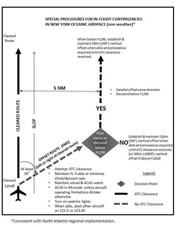
Procedures for In-flight Contingencies in the New York Oceanic CTA/FIR During ASEPS Trial
- Introduction
- The International Civil Aviation Organization's (ICAO) Separation and Airspace Safety Panel (SASP) has submitted a proposal for amendment to ICAO Document 4444, Procedures for Air Navigation Services - Air Traffic Management, which modifies aircraft contingency procedures to support the operational use of Advanced Surveillance Enhanced Procedural Separation (ASEPS) minima. The amendments for the new ASEPS minima and the new contingency procedures are expected to be published in November 2020.
- Three Air Navigation Service Providers (ANSP) in the ICAO North Atlantic (NAT) Region - Gander (Canada), Shanwick (the United Kingdom and Ireland), and Santa Maria (Portugal) are planning to trial the ASEPS minima, using ADS-B as the advanced surveillance, beginning no earlier than March 28, 2019. To support this trial, and maintain regional procedural harmony, all of the NAT ANSPs are planning to implement the proposed contingency procedures at the time the trial starts. The trial is intended to last until November 2020 when the new ASEPS minima are published in ICAO Doc 4444. At that time, the use of trial minima will transition to actual usage by those ANSPs who wish to do so.
- The procedures contained herein are to be used in place of the procedures contained in the U.S. Aeronautical Information Publication (AIP), ENR 7.3, paragraphs 1, 2, and 4 for operations within the entirety of the New York Center oceanic CTA/FIR. The contingency procedures contained in the U.S. AIP, ENR 7.3, paragraphs 1, 2, and 4 remain applicable to operations within the Anchorage and Oakland Air Route Traffic Control Centers.
- Although all possible contingencies cannot be covered, the procedures in paragraphs 2, 3, and 4
provide for the more frequent cases, such as:
- inability to comply with assigned clearance due to meteorological conditions (see paragraph 4);
- enroute diversion across the prevailing traffic flow (for example, due to medical emergencies (see paragraphs 2 and 3); and
- loss of, or significant reduction in, the required navigation capability when operating in
an airspace where the navigation performance accuracy is a prerequisite to the safe conduct
of flight operations, or pressurization failure (see paragraphs 2 and 3).
NOTE-
Guidance on procedures to follow when an aircraft experiences a degradation in navigation capabilities can be found in ICAO Doc 4444, Procedures for Air Navigation Services - Air Traffic Management, chapter 5, section 5.2.2.
- The pilot shall take action as necessary to ensure the safety of the aircraft, and the pilot’s judgement shall determine the sequence of actions to be taken, having regard to the prevailing circumstances. Air traffic control shall render all possible assistance.
- General Procedures
NOTE-
Figure 1 provides an aid for understanding and applying the contingency procedures contained in paragraphs 2 and 3.
- If an aircraft is unable to continue the flight in accordance with its ATC clearance, a revised clearance should be obtained, whenever possible, prior to initiating any action.
- If prior clearance cannot be obtained, the following contingency procedures should be employed until
a revised clearance is received:
- leave the cleared route or track by initially turning at least 30 degrees to the right or to
the left in order to intercept and maintain a parallel, same direction track or route offset
of 9.3 km (5.0 NM). The direction of the turn should be based on one or more of the
following:
- aircraft position relative to any organized track or route system;
- the direction of flights and flight levels allocated on adjacent tracks;
- the direction to an alternate airport;
- any strategic lateral offset being flown; and
- terrain clearance;
- the aircraft should be flown at a flight level and an offset track where other aircraft are less likely to be encountered;
- maintain a watch for conflicting traffic both visually and by reference to ACAS (if equipped) leaving ACAS in RA mode at all times, unless aircraft operating limitations dictate otherwise;
- turn on all aircraft exterior lights (commensurate with appropriate operating limitations);
- keep the SSR transponder on at all times and, when able, squawk 7700, as appropriate;
- as soon as practicable, the pilot shall advise air traffic control of any deviation from assigned clearance;
- use whatever means is appropriate (i.e. voice and/or CPDLC) to communicate during a contingency or emergency;
- if voice communication is used, the radiotelephony distress signal (MAYDAY) or urgency signal (PAN PAN) preferably spoken three times, shall be used, as appropriate;
- when emergency situations are communicated via CPDLC, the controller may respond via CPDLC.
However, the controller may also attempt to make voice communication contact with the
aircraft;
NOTE-
Additional guidance on emergency procedures for controllers and radio operators, and flight crew, in data link operations can be found in the Global Operational Data Link (GOLD) Manual (Doc 10037).
- establish communications with and alert nearby aircraft by broadcasting, at suitable intervals on 121.5 MHz (or, as a backup, on the inter-pilot air-to-air frequency 123.45 MHz) and where appropriate on the frequency in use: aircraft identification, the nature of the distress condition, intention of the person in command, position (including the ATS route designator or the track code, as appropriate) and flight level; and
- the controller should attempt to determine the nature of the emergency and ascertain any assistance that may be required. Subsequent ATC action with respect to that aircraft shall be based on the intentions of the pilot and overall traffic situation.
- leave the cleared route or track by initially turning at least 30 degrees to the right or to
the left in order to intercept and maintain a parallel, same direction track or route offset
of 9.3 km (5.0 NM). The direction of the turn should be based on one or more of the
following:
- Actions to be Taken Once Offset from Track
NOTE-
The pilot’s judgement of the situation and the need to ensure the safety of the aircraft will determine if the actions outlined in 3. b. (1) or (2) will be taken. Factors for the pilot to consider when diverting from the cleared route or track without an ATC clearance include, but are not limited to:
- operation within a parallel track system;
- the potential for User Preferred Routes (UPRs) parallel to the aircraft’s track or route;
- the nature of the contingency (e.g. aircraft system malfunction); and
- weather factors (e.g. convective weather at lower flight levels).
- If possible, maintain the assigned flight level until established on the 9.3 km (5.0 NM) parallel, same direction track or route offset. If unable, initially minimize the rate of descent to the extent that is operationally feasible.
- Once established on a parallel, same direction track or route offset by 9.3 km (5.0 NM), either:
- descend below FL 290, and establish a 150 m (500 ft) vertical offset from those flight
levels normally used, and proceed as required by the operational situation or, if an ATC
clearance has been obtained, proceed in accordance with the clearance; or
NOTE-
Descent below FL 290 is considered particularly applicable to operations where there is a predominant traffic flow (e.g. east-west) or parallel track system where the aircraft’s diversion path will likely cross adjacent tracks or routes. A descent below FL 290 can decrease the likelihood of conflict with other aircraft, ACAS RA events, and delays in obtaining a revised ATC clearance.
- establish a 150 m (500 ft) vertical offset (or 300 m (1000 ft) vertical offset if above FL
410 from those flight levels normally used, and proceed as required by the operational
situation, or if an ATC clearance has been obtained, proceed in accordance with the
clearance.
NOTE-
Altimetry system error may lead to less than actual 500 ft vertical separation when the procedure above is applied. In addition, with the 500 ft vertical offset applied, ACAS RAs may occur.
Figure 1. Visual aid for understanding and applying the contingency procedures guidance
- descend below FL 290, and establish a 150 m (500 ft) vertical offset from those flight
levels normally used, and proceed as required by the operational situation or, if an ATC
clearance has been obtained, proceed in accordance with the clearance; or
- Weather Deviation Procedures
- General
NOTE-
The following procedures are intended for deviations around adverse meteorological conditions.
- When weather deviation is required, the pilot should initiate communications with ATC via
voice or CPDLC. A rapid response may be obtained by either:
- stating, "WEATHER DEVIATION REQUIRED" to indicate that priority is desired on the frequency and for ATC response; or
- requesting a weather deviation using a CPDLC lateral downlink message.
- When necessary, the pilot should initiate the communications using the urgency call "PAN PAN" (preferably spoken three times) or by using a CPDLC urgency downlink message.
- The pilot shall inform ATC when weather deviation is no longer required, or when a weather deviation has been completed and the aircraft has returned to its cleared route.
- When weather deviation is required, the pilot should initiate communications with ATC via
voice or CPDLC. A rapid response may be obtained by either:
- Actions to be Taken When Controller-Pilot Communications are Established
- The pilot should notify ATC and request clearance to deviate from track or route, advising
when possible, the extent of the deviation requested. The flight crew will use whatever
means is appropriate (i.e. CPDLC and/or voice) to communicate during a weather deviation.
NOTE-
Pilots are advised to contact ATC as soon as possible with requests for clearance in order to provide time for the request to be assessed and acted upon.
- ATC should take one of the following actions:
- when appropriate separation can be applied, issue clearance to deviate from track; or
- if there is conflicting traffic and ATC is unable to establish appropriate
separation, ATC should:
- advise the pilot of inability to issue clearance for the requested deviation;
- advise the pilot of conflicting traffic; and
- request the pilot’s intentions.
- The pilot should take one of the following actions:
- comply with the ATC clearance issued; or
- advise ATC of intentions and execute the procedures provided in paragraph 4.c. below.
- The pilot should notify ATC and request clearance to deviate from track or route, advising
when possible, the extent of the deviation requested. The flight crew will use whatever
means is appropriate (i.e. CPDLC and/or voice) to communicate during a weather deviation.
- Actions to be Taken if a Revised ATC Clearance Cannot be Obtained
NOTE-
The provisions of this paragraph apply to situations where a pilot needs to exercise the authority of a pilot-in-command under the provisions of ICAO Annex 2, 2.3.1.
- If the aircraft is required to deviate from track or route to avoid adverse meteorological
conditions, and prior clearance cannot be obtained, an ATC clearance shall be obtained at
the earliest possible time. Until an ATC clearance is received, the pilot shall take the
following actions:
- if possible, deviate away from an organized track or route system;
- establish communications with and alert nearby aircraft by broadcasting, at suitable intervals: aircraft identification, flight level, position (including ATS route designator or the track code) and intentions, on the frequency in use and on 121.5 MHz (or, as a backup, on the inter-pilot air-to-air frequency 123.45 MHz);.
- watch for conflicting traffic both visually and by reference to ACAS (if equipped);
- turn on all aircraft exterior lights (commensurate with appropriate operating limitations);
- for deviations of less than 9.3 km (5.0 NM) from the originally cleared track or route remain at a level assigned by ATC;
- for deviations greater than or equal to 9.3 km (5.0 NM) from the originally cleared track or route, when the aircraft is approximately 9.3 km (5.0 NM) from track, initiate a level change in accordance with the Table below;
- if the pilot receives clearance to deviate from cleared track or route for a specified distance and, subsequently, requests, but cannot obtain a clearance to deviate beyond that distance, the pilot should apply an altitude offset in accordance with the Table below before deviating beyond the cleared distance;
- when returning to track or route, be at its assigned flight level when the aircraft is within approximately 9.3 km (5.0 NM) of the centerline; and
- if contact was not established prior to deviating, continue to attempt to contact
ATC to obtain a clearance. If contact was established, continue to keep ATC advised
of intentions and obtain essential traffic information.
NOTE-
If, as a result of actions taken under the provisions of 4. c. (1), the pilot determines that there is another aircraft at or near the same flight level with which a conflict may occur, then the pilot is expected to adjust the path of the aircraft, as necessary, to avoid conflict.
- If the aircraft is required to deviate from track or route to avoid adverse meteorological
conditions, and prior clearance cannot be obtained, an ATC clearance shall be obtained at
the earliest possible time. Until an ATC clearance is received, the pilot shall take the
following actions:
- General
Altitude Offset When Denied Clearance to Deviate 9.3 km (5.0 NM) or
More, Applicable in New York’s Oceanic Airspace (consistent with North Atlantic
regional implementation)
|
Originally Cleared Track or Route Center Line |
Deviations |
Level Change |
|
EAST |
LEFT
RIGHT |
DESCEND
CLIMB |
|
WEST |
LEFT
RIGHT |
CLIMB
DESCEND |
North Atlantic Trial Implementation of ASEPS (Lateral) Using ADS-B
The ICAO North Atlantic (NAT) region is conducting trials of reduced aircraft separation minimums based on the use of ADS-B. The NAT region officially refers to these aircraft separation minimums as Advanced Surveillance-Enhanced Procedural Separation (ASEPS). The trials, conducted exclusively in the Gander, Shanwick and Santa Maria Oceanic Control Areas (OCA), began in March 2019 with reduced longitudinal separation minimums. The NAT region will expand the trials to include reduced lateral separation minimums, again only in Gander, Shanwick and Santa Maria OCAs, beginning as early as October 10, 2019. During the trials, the participating OCAs may separate aircraft on non-intersecting tracks not less than 19 nautical miles (NM) laterally. Aircraft currently flying on Performance Based Communications and Surveillance (PBCS) tracks in the NAT region can experience lateral spacing limited to 23 NM.
Air traffic controllers for the Gander and Shanwick OCAs will use space based ADS-B for aircraft surveillance during the trials, while controllers for Santa Maria OCA will use their existing ground-based ADS-B network.
As with the PBCS tracks, ATC will limit application of reduced lateral spacing to aircraft whose flight plan indicates authorization for RNP 4, RCP 240, RSP 180, RVSM, and operations in the North Atlantic High Level Airspace (NAT HLA). The flight plan must also indicate equipage with ADS-B out (1090 MHz) (Item 10 codes B1 or B2) and FANS 1/A CPDLC SATCOM (Item 10 codes J5 or J7).
ICAO NAT OPS Bulletin 2019-002 Trial Implementation of ASEPS (Lateral) Using ADS-B is the comprehensive source of guidance and information on the trials. Operators may find this OPS Bulletin, as well as all active NAT OPS Bulletins at www.icao.int/EURNAT. Subsequently click on EUR/NAT Documents, then NAT Region Documents, then NAT OPS Bulletins.
Flight crews crossing the NAT may experience some new and/or non-standard terminology regarding surveillance of their aircraft, particularly as they enter or travel between trial participating OCAs. Regardless of the surveillance status terminology that flight crews hear or receive via CPDLC when in oceanic airspace, they must perform all their normal oceanic procedures.
The FAA recommends flight crews of U.S. aircraft opt out of the ASEPS reduced lateral separation trial if flying with less than a fully functioning TCAS (ACAS II). Flight crews should inform ATC that they have "no ACAS" either when requesting their oceanic clearance (voice or CPDLC), 30 minutes prior to crossing the Gander, Shanwick or Santa Maria OCA boundaries if entering from New York or Iceland oceanic airspace, or otherwise as soon as possible if ACAS failure occurs while in Gander, Shanwick or Santa Maria OCAs.
Strategic Lateral Offset Procedures (SLOP) remain in effect during ASEPS trials. For safety of operations, flight crews should always use SLOP while within oceanic airspace on their NAT crossing.
Operators who fly across the North Atlantic should ensure their pilots are aware of the reduced lateral separation trials and the information presented in both this notice and NAT OPS Bulletin 2019-002.
For questions regarding this notice contact the Flight Technologies and Procedures Division, 202-267-8790.
(Flight Operations Group, Flight Technologies and Procedures Division, Flight Standards Service, 8/15/19)
NORTH ATLANTIC OPERATIONS WITHOUT AN ASSIGNED FIXED SPEED
- The purpose of the notice is to alert operators flying in the International Civil Aviation Organization (ICAO) North Atlantic (NAT) region of opportunities to fly other than a fixed speed. A speed assignment has long been a component of a NAT oceanic clearance. As a result of extensive coordination among NAT air navigation service providers (ANSP), operators may now have the opportunity to fly a variable speed, for all or a portion of their NAT oceanic crossing. NAT ANSPs are implementing operations without an assigned fixed speed as changes to their individual flight data processing systems and procedures allow. Therefore, the opportunities to fly other than a fixed speed will vary with the oceanic control area, traffic density, and direction of flight.
- ICAO NAT OPS Bulletin 2019-1 Operations Without an Assigned Fixed Speed in the NAT (OWAFS) Special Emphasis Items (SEI), issued July 9, 2019, is the comprehensive source of information on operations without an assigned fixed speed in the NAT. The bulletin includes an example operational scenario illustrating how a nominal oceanic flight crew may obtain clearance to fly other than a fixed assigned speed in the NAT. It is important to note that, in accordance with Title 14 of the Code of Federal Regulations, § 91.703, operators must observe the provisions of paragraph 3.6.2.2 of ICAO Annex 2. Operators should not interpret anything in the bulletin as authorizing a deviation from Annex 2.
- Operators can obtain this bulletin, as well as all NAT OPS Bulletins, free of charge on the ICAO EUR/NAT website. Visitors to the website should select EUR/NAT Documents, then NAT Documents, then NAT OPS Bulletins to view the complete list of effective bulletins. All U.S. operators intending flights in the NAT region should familiarize themselves with all current NAT OPS Bulletins.
- Operators may direct questions to Aviation Safety Inspector Madison Walton, Flight Technologies and Procedures Division, at 202-267-8850, or Madison.Walton@faa.gov.
(Flight Operations Group, Flight Technologies and Procedures Division, Flight Standards Service, 9/12/2019)
STRATEGIC LATERAL OFFSET PROCEDURE (SLOP) WHILE WITHIN OCEANIC AIRSPACE
The strategic lateral offset procedure (SLOP) has been promoted and practiced in oceanic airspace for a number of years. The standards for SLOP have been established by ICAO through Document 4444, Procedures for Air Navigation Services - Air Traffic Management. Until recently, application of SLOP offered aircraft operators options only to fly the track centerline, 1.0 NM, or 2.0 NM right of track. However, a change to the International Civil Aviation Organization Document 4444, Procedures for Air Navigation Services - Air Traffic Management, established new criteria for SLOP such that offsets may be performed at .1 NM intervals up to a maximum of 2.0 NM right of track. The new criteria will allow 21 offset positions versus the existing three positions, thereby, increasing safety. These procedures will be published in the United States Aeronautical Information Publication on 30 January 2020.
It has been determined that allowing aircraft conducting oceanic flight to fly lateral offsets, in increments of .1 nautical mile (NM) up to a maximum of 2 NM right of center line, will provide an additional safety margin and mitigate the risk of conflict when non-normal events, such as aircraft navigation errors, altitude deviation errors, and turbulence-induced altitude-keeping errors occur.
Effective 12 September 2019, these procedures are authorized in U.S.-controlled Oceanic Airspace and also the airspace surrounding the island of Bermuda, the airspace controlled by Honolulu Control Facility (HCF) and the airspace controlled by Guam Combined Center Radar Approach Control (CERAP).
These procedures provide for offsets within the following guidelines: Along a route or track there will be 21 positions that an aircraft may fly: on center line or at increments of .1 NM (e.g. .1, .2, .3, .4 ….. 1.8, 1.9, 2.0) right of center line out to a maximum offset of 2 NM. Offsets must not exceed 2 NM right of centerline. The intent of this procedure is to reduce risk (add safety margin) by distributing aircraft laterally across the 21 available positions.
Pilots must fly the track center line if their aircraft does not have automatic offset programming capability. Pilots of aircraft unable to offset at .1 NM increments should fly on the track centerline, or at the 1.0 NM or 2.0 NM positions right of centerline when using SLOP.
An aircraft overtaking another aircraft should offset within the confines of this procedure, if capable, so as to create the least amount of wake turbulence for the aircraft being overtaken.
Pilots should also fly one of the available offset positions shown above to avoid wake turbulence.
(9/12/2019)
Trial to Remove Flight planning requirement of
Eastbound North American Routes (NAR)
Background
For several decades, eastbound aircraft transitioning from North America to Europe have been required to flight plan a North American Route (NAR) with the associated oceanic entry point (OEP) of their preferred oceanic track, as outlined in the U.S. Northeast Chart Supplement and Canada Flight Supplement (CFS).
Given the desire from operators to have the ability to flight plan more efficiently and optimize their routings, NAV CANADA and the Federal Aviation Administration (FAA) have embarked on a project to remove this flight-planning requirement on a trial basis, as outlined below.
Trial Details
Beginning in January 2020, departures from several North American cities will have the ability to optimize their routings to the OEP. This will be a gradual introduction of departure points and operators as the trial moves forward in five stages. Additional departure airports may be considered as the trial moves forward and the impact of the change has been adequately evaluated.
Note: At all times, in every stage, departures must still comply with any departure routes, structures, and/or restrictions from the departure airport. Optimized routings can only begin from points within the Boston air route traffic control center (ARTCC), Moncton flight information region (FIR) airspace or both. Once inside the Boston ARTCC/Moncton FIR area, random routings to the OEP will be permitted. Flight paths of aircraft participating in the trial must remain at or north of a VITOL-LOMPI line. The daily ZBW North Atlantic Advisory shall be the primary method of communicating specifics of this trial.
|
Stage Number |
Date |
Description |
|
Stage 1 |
6 January 2020 to |
All flights operated by Air Canada, departing from CYYZ and CYUL, operating within the organized track structure (OTS) will not be required to file the associated NAR listed on the daily ZBW North Atlantic Advisory. Associated NARs are referenced under the "JFK Departures" section of the advisory. |
|
Stage 2 |
20 January 2020 to |
All flights departing from CYYZ and CYUL, operating within the OTS, will not be required to file the associated NAR listed on the daily ZBW North Atlantic Advisory. Associated NARs are referenced under the "JFK Departures" section of the advisory. |
|
Stage 3 |
3 February 2020 to |
All flights as indicated in Stage 1 and Stage 2 in addition to American airlines flights departing from KORD, operating within the OTS will not be required to file the associated NAR listed on the daily ZBW North Atlantic Advisory. Associated NARs are referenced under the "JFK Departures" section of the advisory. |
|
Stage 4 |
17 February 2020 to |
All flights departing from CYYZ, CYUL and KORD, operating within the OTS will not be required to file the associated NAR listed on the daily ZBW North Atlantic Advisory. Associated NARs are referenced under the "JFK Departures" section of the advisory. |
|
Stage 5 |
2 March 2020 to |
All flights departing from CYYZ, CYUL, KORD, KDTW and KMSP, operating within the OTS will not be required to file the associated NAR listed on the daily ZBW North Atlantic Advisory. Associated NARs are referenced under the "JFK Departures" section of the advisory. |
ICAO NOTAMS will be issued in conjunction with each stage of this trial.
The trial may be discontinued at any time, based on the operational impact of the trial. If the trial is discontinued, dispatchers and operators shall revert back to the OTS structure. Please refer to the daily ZBW North Atlantic Advisory for specific information and status of this trial.
Dispatchers shall include "NO NARS EAST TRIAL" in the remarks section of flight plans for participating aircraft.
Flight crews are expected to carry applicable NAR documentation on the flight deck for all flights, regardless if participating in the trial or not.
For further information, please contact:
Steve Schmidt
Traffic Management Officer, Boston District
35 Northeastern Blvd.
Nashua, NH 03062
Office.:1-603-879-6033
Operations:1-603-879-6666
Support:1-603-879-6808
E-mail:s.gunther.schmidt@faa.gov
NAV CANADA
Customer Service
77 Metcalfe Street
Ottawa, ON K1P 5L6
Tel.: 800-876-4693
Fax: 877-663-6656
E-mail:service@navcanada.ca
(01/02/2020)