2025 Burning Man
Black rock desert, nevada
august 20, 202 - september 2, 2025
Background
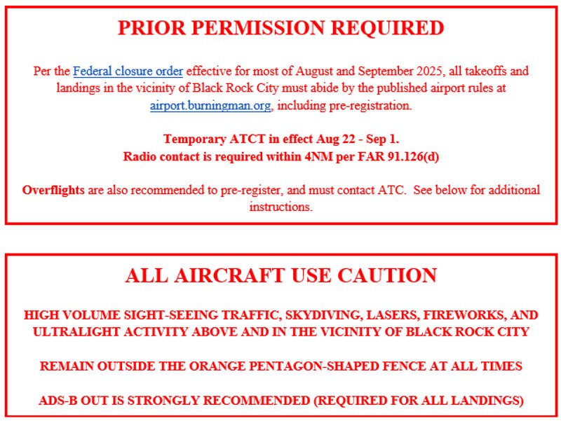
The purpose of this Notice is to inform all pilots of special procedure that will be implemented during Burning Man, August 20, 2025 – September 2, 2025, in the vicinity of Black Rock Desert, NV. During this event a private-use airport, Black Rock City Municipal Airport (88NV), is created and prepared by Black Rock City LLC on land owned by the Bureau of Land Management (BLM).
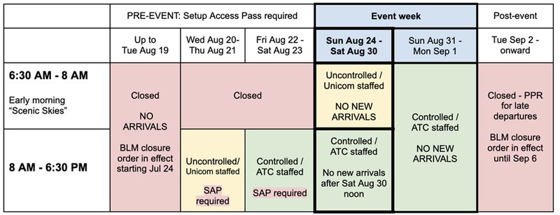
AIRPORT EFFECTIVE DATES AND HOURS
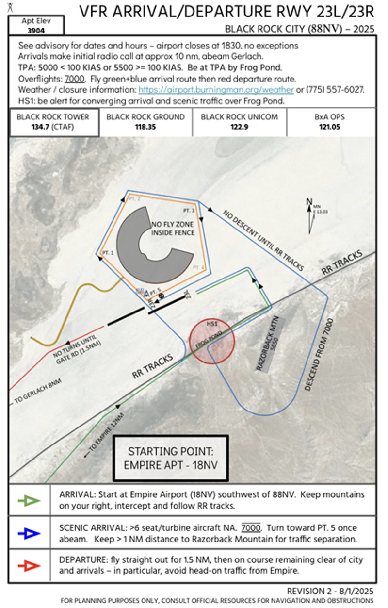
sIGHTSEEING FLIGHT procedure
Pilots that wish to orbit Black Rock City are encouraged to pre-register at airport.burningman.org, download the charts, and check the advisory there.
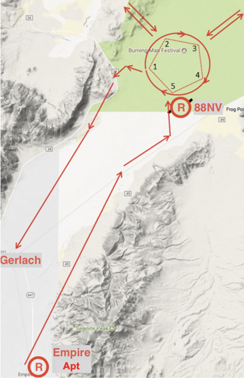
To perform a scenic orbit and then depart, aircraft should maintain 7000’ MSL starting at Empire Airport (18NV), make contact with 88NV on 134.7 within ten miles, remain outside of the pentagon-shaped city perimeter fence, and circle clockwise as depicted below.
SKYDIVING IN PROGRESS DAY AND NIGHT – DO NOT FLY INSIDE THE PENTAGON-SHAPED EVENT FENCE FOR ANY REASON.
Airport Information
FAA Airport Identifier | 88NV |
Airport Coordinates | 40°45'49.4"N 119°12'37.8"W – 65 NM SW of KWMC |
Field Elevation | 3904’ MSL |
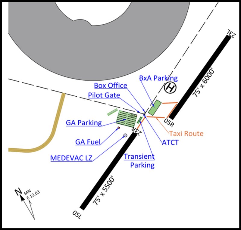
Diagram & Runways |
23L / 5R - 6000’ x 75’ using cones 23R / 5L - 5500’ x 75’ using cones Right traffic runways 5 Helipad H1 - marked with cones: 40°45.9353' N -119°12.153' W Medevac H2 - marked with cones: 40° 45.7728’N 119° 12.814’ W Calm-wind runways 23 – winds almost always favor 23. |
Surface Conditions | Dry alkaline lakebed. Small dunes of powdery, soft soil. Runways and taxi areas conditioned by rolling and watering. |
5000’ MSL for aircraft flying below 100 KIAS on downwind. 5500’ MSL for aircraft at or above 100 KIAS. | |
Frequencies | 134.7 - Black Rock Tower / CTAF 118.35 - Black Rock Ground 128.8 - Oakland Center (>10,000 MSL) |
Weather | Current conditions available online at airport.burningman.org/weather, via radio, or as a last resort, via ATC phone at (775) 557-6027 |
Oakland Air Route Traffic control center information
Oakland Air Route Traffic Control Center requests the following from aircraft transiting to and from 88NV airport:
- Departing Aircraft requesting VFR flight following West and Southbound should contact Oakland Center on Frequency: 128.8.
- Departing Aircraft requesting VFR flight following North and Eastbound should contact Salt Lake Center on 132.25.
- Radio and Radar coverage is limited in the area of Empire Airport (18NV) and Burning Man airport (88NV) below 10,000ft.
- As of 2024, 88NV is now in Oakland Center’s database and can be used as a destination for flight following.
- Expect radar service to terminate around Empire Airport (18NV). If your Radar service is not terminated and you are approaching Empire Airport, please ask to terminate with ATC. If you leave Oakland Center frequency without termination of Radar service, we will be required to issue an Alert Notice.
- When the frequency is busy, please keep communications to a minimum. The Air Traffic Sector that works Burning Man is large and contains 5 separate transmitters. Because of transmitter location you might not hear other pilots on the frequency.
- Please use caution for Temporary Flight Restrictions (TFR’s) for firefighting operations. If you are receiving flight following from Oakland Center, you are still required to be aware of current TFR’s and NOTAMS along your flight path. If you are getting close to a TFR we will advise and issue a vector.
- If planning on an IFR pickup with Oakland Center, expect a minimum IFR altitude of 13,000 going West over the Sierras and 11,000 going North or East. Lower altitudes are available if flying on airways.
- When en-route to Burning Man, please avoid unnecessary flights in the vicinity of the following airports: KTRK, KRNO and KTVL. These areas will be busy with glider operations and increased traffic loads.
AJV-W22