SPECIAL USE AIRSPACE
Grayling Temporary Military Operations Area, MI
Effective Dates: August 5-23, 2024, for Exercise NORTHERN STRIKE
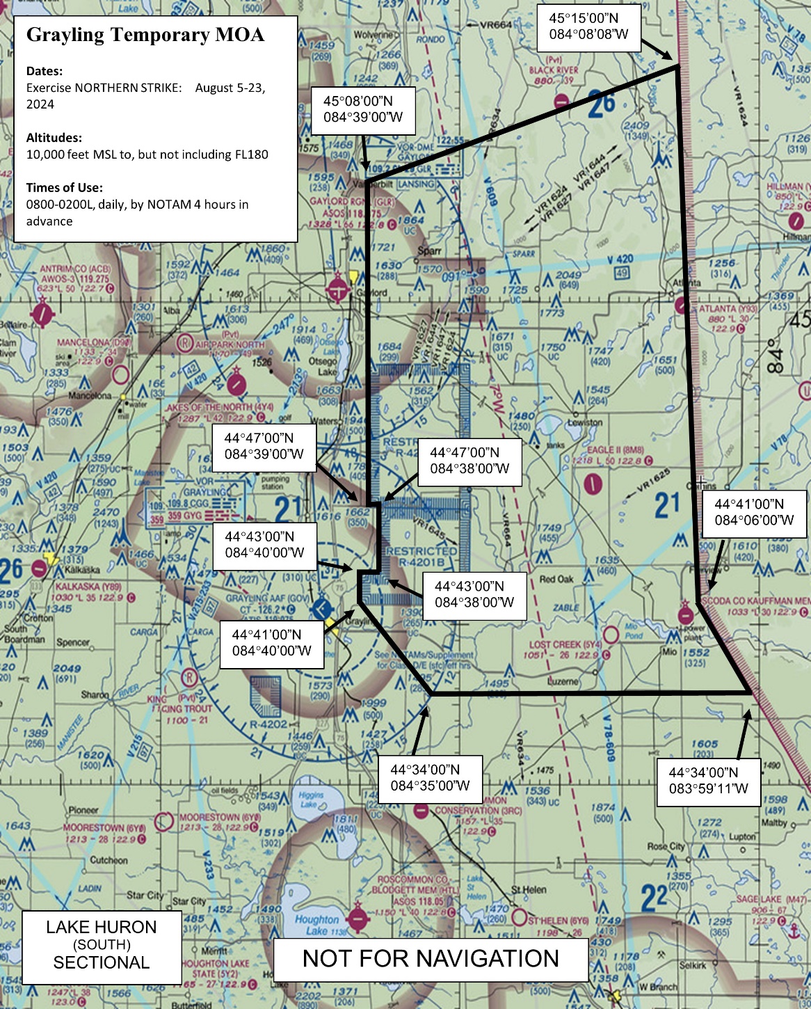
The Grayling Temporary Military Operations Area (TMOA) is established in the vicinity of Grayling, MI, to provide maneuvering airspace between the Grayling Aerial Gunnery Range
(R-4201A & B) and the Pike West MOA in support of Exercise NORTHERN STRIKE. Exercise NORTHERN STRIKE is designed to integrate ground forces with air operations in realistic training scenarios. The execution of these exercises allows combat air forces to practice weapons attack mechanics, target acquisition, and reaction to simulated surface-to-air threats while coordinating with friendly ground elements.
The exercise missions will be conducted from the Alpena Combat Readiness Training Center located at the Alpena County Regional Airport, Alpena, MI; Camp Grayling Joint Maneuver Training Center located at Grayling, MI; and several regional military bases located in MI, OH, MN, and IN, as well as distant bases in ND, VT, and MD. A maximum of 36 sorties per day/night are expected during the exercise. The aircraft types participating in the exercise will include A-10, AV-8, B-1, B-52, C-17, C-130, F-16, F/A-18, and F-35. Activities will occur between 10,000 feet Mean Sea Level (MSL) to, but not including Flight Level 180 (FL180).
The Grayling TMOA will only be activated for aircraft participating in the listed exercise. Mission profiles will consist of typical MOA flight operations to include tactical combat maneuvering by attack and transport category fixed wing aircraft involving abrupt, unpredictable changes in altitude, attitude, and direction of flight. Specifically, the MOA may be used as a holding area for attack aircraft, an air-to-air refueling area, a maneuver area for electronic attack, a maneuver corridor for attack aircraft on ordnance deliveries into R-4201A/B, and to augment the larger Alpena Complex. Supersonic flight and the use of flares is not authorized in the Grayling TMOA; however, chaff will be employed.
Contact the Minneapolis Air Route Traffic Control Center (ARTCC) for status.
Grayling Temporary MOA, MI
Boundaries. Beginning at lat. 45°08’00”N., long. 084°39’00”W.;
to lat. 45°15’00”N., long. 084°08’08”W.;
to lat. 44°41’00”N., long. 084°06’00”W.;
to lat. 44°34’00”N., long. 083°59’11”W.;
to lat. 44°34’00”N., long. 084°35’00”W.;
to lat. 44°41’00”N., long. 084°40’00”W.;
to lat. 44°43’00”N., long. 084°40’00”W.;
to lat. 44°43’00”N., long. 084°38’00”W.;
to lat. 44°47’00”N., long. 084°38’00”W.;
to lat. 44°47’00”N., long. 084°39’00”W.;
to the point of beginning, excluding R-4201A
and R-4201B when active.
Altitudes. 10,000 feet MSL to, but not including FL180.
Times of use. August 5-23, 2024: 0800-0200L, daily, by NOTAM 4 hours in advance.
Altitudes. 10,000 feet MSL to, but not including FL180.
Times of use. August 5-23, 2024: 0800-0200L, daily, by NOTAM 4 hours in advance.
Controlling agency. FAA, Minneapolis ARTCC.
AJV-P21 [ Published 6/30/24]