ENR 1.4 ATS Airspace Classification
1.. General
- There are two categories of airspace or airspace areas:
- Regulatory (Class A, B, C, D, and E airspace areas, restricted and prohibited areas).
- Nonregulatory (military operations areas [MOA], warning areas, alert areas, controlled firing areas [CFA], and national security areas [NSA]).
- Within these two categories, there are four types:
- Controlled.
- Uncontrolled.
- Special use.
- Other airspace.
- The categories and types of airspace are dictated by:
- The complexity or density of aircraft movements.
- The nature of the operations conducted within the airspace.
- The level of safety required.
- The national and public interest.
- It is important that pilots be familiar with the operational requirements for each of the various types or classes of airspace. Subsequent sections will cover each class in sufficient detail to facilitate understanding.
- General Dimensions of Airspace Segments
- Refer to Title 14 of the U.S. Code of Federal Regulations (14 CFR) for specific dimensions, exceptions, geographical areas covered, exclusions, specific transponder/ADS-B or other equipment requirements, and flight operations.
- Hierarchy of Overlapping Airspace Designations
- When overlapping airspace designations apply to the same airspace, the operating rules associated with the more restrictive airspace designation apply.
- For the purpose of clarification:
- Class A airspace is more restrictive than Class B, Class C, Class D, Class E, or Class G airspace.
- Class B airspace is more restrictive than Class C, Class D, Class E, or Class G airspace.
- Class C airspace is more restrictive than Class D, Class E, or Class G airspace.
- Class D airspace is more restrictive than Class E or Class G airspace.
- Class E is more restrictive than Class G airspace.
- Basic VFR Weather Minimums
- No person may operate an aircraft under basic VFR when the flight visibility is less, or at a distance from clouds that is less, than that prescribed for the corresponding altitude and class of airspace. (See TBL ENR 1.4-1.)
- Except as provided in 14 CFR Section 91.157, Special VFR Minimums, no person may operate an aircraft beneath the ceiling under VFR within the lateral boundaries of controlled airspace designated to the surface for an airport when the ceiling is less than 1,000 feet. (See 14 CFR Section 91.155(c).)
- VFR Cruising Altitudes and Flight Levels
(See TBL ENR 1.4-2.)TBL ENR 1.4-1Basic VFR Weather Minimums Airspace
Flight Visibility
Distance from Clouds
Class A
Not Applicable
Not Applicable
Class B
3 statute miles
Clear of Clouds
Class C
3 statute miles
500 feet below
1,000 feet above
2,000 feet horizontalClass D
3 statute miles
500 feet below
1,000 feet above
2,000 feet horizontalClass E
Less than 10,000 feet MSL
3 statute miles
500 feet below
1,000 feet above
2,000 feet horizontalAt or above 10,000 feet MSL
5 statute miles
1,000 feet below
1,000 feet above
1 statute mile horizontalClass G
1,200 feet or less above the surface (regardless of MSL altitude).For aircraft other than helicopters:
Day, except as provided in 14 CFR § 91.155(b)
1 statute mile
Clear of clouds
Night, except as provided in 14 CFR § 91.155(b)
3 statute miles
500 feet below
1,000 feet above
2,000 feet horizontalFor helicopters:
Day
½ statute mile
Clear of clouds
Night, except as provided in §91.155(b)
1 statute mile
Clear of clouds
More than 1,200 feet above the surface but less than 10,000 feet MSL.
Day
1 statute mile
500 feet below
1,000 feet above
2,000 feet horizontalNight
3 statute miles
500 feet below
1,000 feet above
2,000 feet horizontalMore than 1,200 feet above the surface and at or above 10,000 feet MSL.
5 statute miles
1,000 feet below
1,000 feet above
1 statute mile horizontalTBL ENR 1.4-2VFR Cruising Altitudes and Flight Levels If your magnetic course
(ground track) is:And you are more than 3,000 feet above the surface but below 18,000 feet MSL, fly:
And you are above 18,000 feet MSL
to FL 290, fly:0¥ to 179¥
Odd thousands MSL, plus 500 feet (3,500; 5,500; 7,500, etc.)
Odd Flight Levels plus 500 feet
(FL 195; FL 215; FL 235, etc.)180¥ to 359¥
Even thousands MSL, plus 500 feet (4,500; 6,500; 8,500, etc.)
Even Flight Levels plus 500 feet
(FL 185; FL 205; FL 225, etc.)
2.. Controlled Airspace
- General
- Controlled Airspace. A generic term that covers the different classification of airspace (Class A, Class B, Class C, Class D, and Class E airspace) and defined dimensions within which air traffic control service is provided to IFR flights and to VFR flights in accordance with the airspace classification. (See FIG ENR 1.4-1 for Airspace Classes). Airspace classes are pronounced in the ICAO phonetics for clarification. The term “class” may be dropped when referring to airspace in pilot/controller communications.
- IFR Requirements. IFR operations in any class of controlled airspace requires that a pilot must file an IFR flight plan and receive an appropriate ATC clearance.
- IFR Separation. Standard IFR separation is provided to all aircraft operating under IFR in controlled airspace.
- VFR Requirements. It is the responsibility of the pilot to insure that ATC clearance or radio communication requirements are met prior to entry into Class B, Class C, or Class D airspace. The pilot retains this responsibility when receiving ATC radar advisories. (See 14 CFR Part 91.)
- Traffic Advisories. Traffic advisories will be provided to all aircraft as the controller's work situation permits.
- Safety Alerts. Safety Alerts are mandatory services and are provided to ALL aircraft. There are two types of Safety Alerts, Terrain/Obstruction Alert and Aircraft Conflict/Mode Intruder Alert.
- Terrain/Obstruction Alert. A Terrain/Obstruction Alert is issued when, in the controller's judgment, an aircraft's altitude places it in unsafe proximity to terrain and/or obstructions.
FIG ENR 1.4-1Airspace Classes 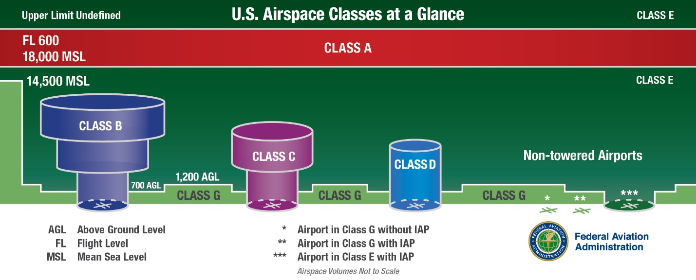
- Aircraft Conflict/Mode C Intruder Alert. An Aircraft Conflict/Mode C Intruder Alert is issued if the controller observes another aircraft which places it in an unsafe proximity. When feasible, the controller will offer the pilot an alternative course of action.
- Terrain/Obstruction Alert. A Terrain/Obstruction Alert is issued when, in the controller's judgment, an aircraft's altitude places it in unsafe proximity to terrain and/or obstructions.
- Ultralight Vehicles. No person may operate an ultralight vehicle within Class A, Class B, Class C, or Class D airspace or within the lateral boundaries of the surface area of Class E airspace designated for an airport unless that person has prior authorization from the ATC facility having jurisdiction over that airspace. (See 14 CFR Part 103.)
- Unmanned Free Balloons. Unless otherwise authorized by ATC, no person may operate an unmanned free balloon below 2,000 feet above the surface within the lateral boundaries of Class B, Class C, Class D, or Class E airspace designated for an airport. (See 14 CFR Part 101.)
- Parachute Jumps. No person may make a parachute jump, and no pilot in command may allow a parachute jump to be made from that aircraft, in or into Class A, Class B, Class C, or Class D airspace without, or in violation of, the terms of an ATC authorization issued by the ATC facility having jurisdiction over the airspace. (See 14 CFR Part 105.)
- Class A Airspace
- Definition. Generally, that airspace from 18,000 feet MSL up to and including FL 600, including the airspace overlying the waters within 12 nautical miles off the coast of the 48 contiguous States and Alaska; and designated international airspace beyond 12 nautical miles off the coast of the 48 contiguous States and Alaska within areas of domestic radio navigational signal or ATC radar coverage, and within which domestic procedures are applied.
- Operating Rules and Pilot/Equipment Requirements. Unless otherwise authorized, all persons must operate their aircraft under IFR.
- Charts. Class A airspace is not specifically charted.
- Class B Airspace
- Definition. Generally, that airspace from the surface to 10,000 feet MSL surrounding the nation's busiest airports in terms of IFR operations or passenger enplanements. The configuration of each Class B airspace area is individually tailored and consists of a surface area and two or more layers (some Class B airspace areas resemble upside-down wedding cakes), and is designed to contain all published instrument procedures once an aircraft enters the airspace. An ATC clearance is required for all aircraft to operate in the area, and all aircraft that are so cleared receive separation services within the airspace. The cloud clearance requirement for VFR operations is “clear of clouds.”
- Operating Rules and Pilot/Equipment Requirements. Regardless of weather conditions, an ATC clearance is required prior to operating within Class B airspace. Pilots should not request a clearance to operate within Class B airspace unless the requirements of 14 CFR Sections 91.131, 91.215, and 91.225 are met. Included among these requirements are:
- Unless otherwise authorized by ATC, aircraft must be equipped with an operable two-way radio capable of communicating with ATC on appropriate frequencies for that Class B airspace.
- No person may take off or land a civil aircraft at the following primary airports within Class B airspace unless the pilot in command holds at least a private pilot certificate:
- Andrews Air Force Base, MD.
- Atlanta Hartsfield Airport, GA.
- Boston Logan Airport, MA.
- Chicago O'Hare Intl. Airport, IL.
- Dallas/Fort Worth Intl. Airport, TX.
- Los Angeles Intl. Airport, CA.
- Miami Intl. Airport, FL.
- Newark Intl. Airport, NJ.
- New York Kennedy Airport, NY.
- New York La Guardia Airport, NY.
- Ronald Reagan Washington National Airport, DC.
- San Francisco Intl. Airport, CA.
- No person may take off or land a civil aircraft at an airport within Class B airspace or operate a civil aircraft within Class B airspace unless:
- The pilot in command holds at least a private pilot certificate; or
- The pilot-in-command holds a recreational pilot certificate and has met the requirements of 14 CFR Section 61.101; or
- The pilot-in-command holds a sport pilot certificate and has met the requirements of 14 CFR Section 61.325; or
- The aircraft is operated by a student pilot:
- Who seeks a private pilot certificate and has met the requirements of 14 CFR Section 61.95.
- Who seeks a recreational pilot or sport pilot certificate and has met the requirements of 14 CFR Section 61.94.
- Unless otherwise authorized by ATC, each person operating a large turbine engine-powered airplane to or from a primary airport must operate at or above the designated floors while within the lateral limits of Class B airspace.
- Unless otherwise authorized by ATC, each aircraft must be equipped as follows:
- For IFR operations, an operable VOR or TACAN receiver or an operable and suitable RNAV system; and
- For all operations, a two-way radio capable of communications with ATC on appropriate frequencies for that area.
- Unless otherwise authorized by ATC, an operable radar beacon transponder with automatic altitude reporting capability and operable ADS-B Out equipment.
- Mode C Veil
- The airspace within 30 nautical miles of an airport listed in Appendix D, Section 1 of 14 CFR Part 91 (generally primary airports within Class B airspace areas), from the surface upward to 10,000 feet mean seal level (MSL). Unless otherwise authorized by air traffic control, aircraft operating within this airspace must be equipped with operable radar beacon transponder with automatic altitude reporting capability and operable ADS-B Out equipment.
- However, aircraft that were not originally certificated with an engine-driven electrical system or that have not subsequently been certified with a system installed may conduct operations within a Mode C veil provided the aircraft remains outside Class A, B or C airspace; and below the altitude of the ceiling of a Class B or Class C airspace area designated for an airport or 10,000 feet MSL, whichever is lower.
- Charts. Class B airspace is charted on Sectional Charts, IFR En Route Low Altitude Charts, and Terminal Area Charts.
- Flight Procedures
- Flights. Aircraft within Class B airspace are required to operate in accordance with current IFR procedures. A clearance for a visual approach to a primary airport is not authorization for turbine powered airplanes to operate below the designated floors of the Class B airspace.
- VFR Flights
- Arriving aircraft must obtain an ATC clearance prior to entering Class B airspace and must contact ATC on the appropriate frequency, and in relation to geographical fixes shown on local charts. Although a pilot may be operating beneath the floor of the Class B airspace on initial contact, communications with ATC should be established in relation to the points indicated for spacing and sequencing purposes.
- Departing aircraft require a clearance to depart Class B airspace and should advise the clearance delivery position of their intended altitude and route of flight. ATC will normally advise VFR aircraft when leaving the geographical limits of the Class B airspace. Radar service is not automatically terminated with this advisory unless specifically stated by the controller.
- Aircraft not landing or departing the primary airport may obtain an ATC clearance to transit the Class B airspace when traffic conditions permit and provided the requirements of 14 CFR Section 91.131 are met. Such VFR aircraft are encouraged, to the extent possible, to operate at altitudes above or below the Class B airspace or transit through established VFR corridors. Pilots operating in VFR corridors are urged to use frequency 122.750 MHz for the exchange of aircraft position information.
- ATC Clearances and Separation. An ATC clearance is required to enter and operate within Class B airspace. VFR pilots are provided sequencing and separation from other aircraft while operating within Class B airspace. (See ENR 1.1, paragraph 40., Terminal Radar Service for VFR Aircraft.)
- VFR aircraft are separated from all VFR/IFR aircraft which weigh 19,000 pounds or less by a minimum of:
- Target resolution; or
- 500 feet vertical separation; or
- Visual separation.
- VFR aircraft are separated from all VFR/IFR aircraft which weigh more than 19,000 and turbojets by no less than:
- 1 1/2 miles lateral separation; or
- 500 feet vertical separation; or
- Visual separation.
- This program is not to be interpreted as relieving pilots of their responsibilities to see and avoid other traffic operating in basic VFR weather conditions, to adjust their operations and flight path as necessary to preclude serious wake encounters, to maintain appropriate terrain and obstruction clearance, or to remain in weather conditions equal to or better than the minimums required by 14 CFR Section 91.155. Approach control should be advised and a revised clearance or instruction obtained when compliance with an assigned route, heading, and/or altitude is likely to compromise pilot responsibility with respect to terrain and obstruction clearance, vortex exposure, and weather minimums.
- ATC may assign altitudes to VFR aircraft that do not conform to 14 CFR Section 91.159. “RESUME APPROPRIATE VFR ALTITUDES” will be broadcast when the altitude assignment is no longer needed for separation or when leaving Class B airspace. Pilots must return to an altitude that conforms to 14 CFR Section 91.159.
- Proximity Operations. VFR aircraft operating in proximity to Class B airspace are cautioned against operating too closely to the boundaries, especially where the floor of the Class B airspace is 3,000 feet or less above the surface or where VFR cruise altitudes are at or near the floor of higher levels. Observance of this precaution will reduce the potential for encountering an aircraft operating at the altitudes of Class B floors. Additionally, VFR aircraft are encouraged to utilize the VFR Planning Chart as a tool for planning flight in proximity to Class B airspace. Charted VFR Flyway Planning charts are published on the back of the existing VFR Terminal Area Charts.
- VFR aircraft are separated from all VFR/IFR aircraft which weigh 19,000 pounds or less by a minimum of:
- Class C Airspace
- Definition. Generally, that airspace from the surface to 4,000 feet above the airport elevation (charted in MSL) surrounding those airports that have an operational control tower, are serviced by a radar approach control, and that have a certain number of IFR operations or passenger enplanements. Although the configuration of each Class C airspace area is individually tailored, the airspace usually consists of a surface area with a 5 NM radius, and an outer area with a 10 NM radius that extends no lower than 1,200 feet up to 4,000 feet above the airport elevation.
- Outer Area. Class C airspace areas have a procedural (nonregulatory) Outer Area. Normally this area is 20 NM from the primary Class C airspace airport. Its vertical limit extends from the lower limits of radio/radar coverage up to the ceiling of the approach control's delegated airspace, excluding the Class C airspace itself, and other airspace as appropriate. (This outer area is not charted.)
- Charts. Class C airspace is charted on Sectional Charts, IFR En Route Low Altitude, and Terminal Area Charts where appropriate.
- Operating Rules and Pilot Equipment Requirements
- Pilot Certification. No specific certification required.
- Equipment
- Two‐way radio.
- Unless otherwise authorized by ATC, an operable radar beacon transponder with automatic altitude reporting capability and operable ADS-B Out equipment.
- Within the 48 contiguous states and the District of Columbia at and above 10,000 feet MSL, excluding the airspace at and below 2,500 feet above the surface, and
- At and above 3,000 feet MSL over the Gulf of America from the coastline of the United States out to 12 nautical miles.
- Arrival or Through Flight Entry Requirements. Two-way radio communication must be established with the ATC facility providing ATC services prior to entry and thereafter maintain those communications while in Class C airspace. Pilots of arriving aircraft should contact the Class C airspace ATC facility on the publicized frequency and give their position, altitude, radar beacon code, destination, and request Class C service. Radio contact should be initiated far enough from the Class C airspace boundary to preclude entering Class C airspace before two-way radio communications are established.
- Departures from:
- A primary or satellite airport with an operating control tower. Two-way radio communications must be established and maintained with the control tower, and thereafter as instructed by ATC while operating in Class C airspace.
- A satellite airport without an operating control tower. Two-way radio communications must be established as soon as practicable after departing with the ATC facility having jurisdiction over the Class C airspace.
- Aircraft Speed. Unless otherwise authorized or required by ATC, no person may operate an aircraft at or below 2,500 feet above the surface within 4 nautical miles of the primary airport of a Class C airspace area at an indicated airspeed of more than 200 knots (230 mph).
- Air Traffic Services. When two-way radio communications and radar contact are established, all VFR aircraft are:
- Sequenced to the primary airport.
- Provided Class C services within the Class C airspace and the Outer Area.
- Provided basic radar services beyond the outer area on a workload permitting basis. This can be terminated by the controller if workload dictates.
- Aircraft Separation. Separation is provided within the Class C airspace and the Outer Area after two-way radio communications and radar contact are established. VFR aircraft are separated from IFR aircraft within the Class C airspace by any of the following:
- Visual separation.
- 500 feet vertical separation.
- Target resolution.
- Wake turbulence separation will be provided to all aircraft operating:
- Behind and less than 1,000 feet below super or heavy aircraft,
- To small aircraft operating behind and less than 500 feet below B757 aircraft, and
- To small aircraft following a large aircraft on final approach.
- Secondary Airports
- In some locations, Class C airspace may overlie the Class D surface area of a secondary airport. In order to allow that control tower to provide service to aircraft, portions of the overlapping Class C airspace may be procedurally excluded when the secondary airport tower is in operation. Aircraft operating in these procedurally excluded areas will only be provided airport traffic control services when in communication with the secondary airport tower.
- Aircraft proceeding inbound to a satellite airport will be terminated at a sufficient distance to allow time to change to the appropriate tower or advisory frequency. Class C services to these aircraft will be discontinued when the aircraft is instructed to contact the tower or change to advisory frequency.
- Aircraft departing secondary controlled airports will not receive Class C services until they have been radar identified and two-way communications have been established with the Class C airspace facility.
- This program is not to be interpreted as relieving pilots of their responsibilities to see and avoid other traffic operating in basic VFR weather conditions, to adjust their operations and flight path as necessary to preclude serious wake encounters, to maintain appropriate terrain and obstruction clearance, or to remain in weather conditions equal to or better than the minimums required by 14 CFR Section 91.155. Approach control should be advised and a revised clearance or instruction obtained when compliance with an assigned route, heading, and/or altitude is likely to compromise pilot responsibility with respect to terrain and obstruction clearance, vortex exposure, and weather minimums.
- Class C Airspace Areas By State
These states currently have designated Class C airspace areas that are depicted on sectional charts. Pilots should consult current sectional charts and NOTAMs for the latest information on services available. Pilots should be aware that some Class C airspace underlies or is adjacent to Class B airspace. (See TBL ENR 1.4-3.)
TBL ENR 1.4-3Class C Airspace Areas by State State/City
Airport
ALABAMA
Birmingham
Birmingham-Shuttlesworth
InternationalHuntsville
International-Carl T Jones Fld
Mobile
Regional
ALASKA
Anchorage
Ted Stevens International
ARIZONA
Davis-Monthan
AFB
Tucson
International
ARKANSAS
Fayetteville (Springdale)
Northwest Arkansas Regional
Little Rock
Adams Field
CALIFORNIA
Beale
AFB
Burbank
Bob Hope
Fresno
Yosemite International
Monterey
Peninsula
Oakland
Metropolitan Oakland
InternationalOntario
International
Riverside
March AFB
Sacramento
International
San Jose
Norman Y. Mineta International
Santa Ana
John Wayne/Orange County
Santa Barbara
Municipal
COLORADO
Colorado Springs
Municipal
CONNECTICUT
Windsor Locks
Bradley International
FLORIDA
Daytona Beach
International
Fort Lauderdale
Hollywood International
Fort Myers
SW Florida Regional
Jacksonville
International
Orlando
Sanford International
Palm Beach
President Donald J. Trump International
Pensacola
NAS
Pensacola
International
Sarasota
Bradenton International
Tallahassee
Regional
Whiting
NAS
GEORGIA
Savannah
Hilton Head International
HAWAII
Kahului
Kahului
IDAHO
Boise
Air Terminal
ILLINOIS
Champaign
Urbana U of Illinois-Willard
Chicago
Midway International
State/City
Airport
Moline
Quad City International
Peoria
Greater Peoria Regional
Springfield
Abraham Lincoln Capital
INDIANA
Evansville
Regional
Fort Wayne
International
Indianapolis
International
South Bend
Regional
IOWA
Cedar Rapids
The Eastern Iowa
Des Moines
International
KANSAS
Wichita
Mid-Continent
KENTUCKY
Lexington
Blue Grass
Louisville
International-Standiford Field
LOUISIANA
Baton Rouge
Metropolitan, Ryan Field
Lafayette
Regional
Shreveport
Barksdale AFB
Shreveport
Regional
MAINE
Bangor
International
Portland
International Jetport
MICHIGAN
Flint
Bishop International
Grand Rapids
Gerald R. Ford International
Lansing
Capital City
MISSISSIPPI
Columbus
AFB
Jackson
Jackson-Evers International
MISSOURI
Springfield
Springfield-Branson National
MONTANA
Billings
Logan International
NEBRASKA
Lincoln
Lincoln
Omaha
Eppley Airfield
Offutt
AFB
NEVADA
Reno
Reno/Tahoe International
NEW HAMPSHIRE
Manchester
Manchester
NEW JERSEY
Atlantic City
International
NEW MEXICO
Albuquerque
International Sunport
NEW YORK
Albany
International
Buffalo
Niagara International
Islip
Long Island MacArthur
Rochester
Greater Rochester International
State/City
Airport
Syracuse
Hancock International
NORTH CAROLINA
Asheville
Regional
Fayetteville
Regional/Grannis Field
Greensboro
Piedmont Triad International
Pope
AFB
Raleigh
Raleigh-Durham International
OHIO
Akron
Akron-Canton Regional
Columbus
Port Columbus International
Dayton
James M. Cox International
Toledo
Express
OKLAHOMA
Oklahoma City
Will Rogers World
Tinker
AFB
Tulsa
International
OREGON
Portland
International
PENNSYLVANIA
Allentown
Lehigh Valley International
PUERTO RICO
San Juan
Luis Munoz Marin International
RHODE ISLAND
Providence
Theodore Francis Green State
SOUTH CAROLINA
Charleston
AFB/International
Columbia
Metropolitan
Greer
Greenville-Spartanburg
InternationalMyrtle Beach
Myrtle Beach International
Shaw
AFB
TENNESSEE
Chattanooga
Lovell Field
Knoxville
McGhee Tyson
State/City
Airport
Nashville
International
TEXAS
Abilene
Regional
Amarillo
Rick Husband International
Austin
Austin-Bergstrom International
Corpus Christi
International
Dyess
AFB
El Paso
International
Harlingen
Valley International
Laughlin
AFB
Lubbock
Preston Smith International
Midland
International
San Antonio
International
VERMONT
Burlington
International
VIRGIN ISLANDS
St. Thomas
Charlotte Amalie Cyril E. King
VIRGINIA
Richmond
International
Norfolk
International
Roanoke
Regional/Woodrum Field
WASHINGTON
Point Roberts
Vancouver International
Spokane
Fairchild AFB
Spokane
International
Whidbey Island
NAS, Ault Field
WEST VIRGINIA
Charleston
Yeager
WISCONSIN
Green Bay
Austin Straubel International
Madison
Dane County Regional-Traux Field
Milwaukee
General Mitchell International
- Class D Airspace
- Definition. Generally, Class D airspace extends upward from the surface to 2,500 feet above the airport elevation (charted in MSL) surrounding those airports that have an operational control tower. The configuration of each Class D airspace area is individually tailored and when instrument procedures are published, the airspace will normally be designed to contain the procedures.
- Class D surface areas may be designated as full‐time or part‐time. Part‐time Class D effective times are published in the Chart Supplement.
- Part-time Class D surface areas may default to either a Class E surface area or Class G airspace. When a part–time Class D surface area defaults to Class G, the surface area airspace becomes Class G up to, but not including, the overlying controlled airspace. Normally, the overlying controlled airspace is the Class E transition area airspace that begins at either 700 feet or 1200 feet AGL. This may be determined by consulting the applicable VFR Sectional or Terminal Area Charts.
- Operating Rules and Pilot Equipment Requirements
- Pilot Certification. No specific certification required.
- Equipment. Unless otherwise authorized by ATC, an operable two-way radio is required.
- Arrival or Through Flight Entry Requirements. Two-way radio communication must be established with the ATC facility providing ATC services prior to entry and thereafter maintain those communications while in the Class D airspace. Pilots of arriving aircraft should contact the control tower on the publicized frequency and give their position, altitude, destination, and any request(s). Radio contact should be initiated far enough from the Class D airspace boundary to preclude entering the Class D airspace before two-way radio communications are established.
- Departures from:
- A primary or satellite airport with an operating control tower. Two-way radio communications must be established and maintained with the control tower, and thereafter as instructed by ATC while operating in the Class D airspace.
- A satellite airport without an operating control tower. Two-way radio communications must be established with the ATC facility having jurisdiction over the Class D airspace as soon as practicable after departing.
- Aircraft Speed. Unless otherwise authorized or required by ATC, no person may operate an aircraft at or below 2,500 feet above the surface within 4 nautical miles of the primary airport of a Class D airspace area at an indicated airspeed of more than 200 knots (230 mph).
- Class D airspace areas are depicted on Sectional and Terminal charts with blue segmented lines, and on IFR En Route Low Altitude charts with a boxed [D].
- Arrival extensions.
- Class D airspace arrival extensions for instrument approach procedures may be Class D or Class E airspace. As a general rule, if all extensions are 2 miles or less, they remain part of the Class D surface area. However, if any one extension is greater than 2 miles, then all extensions become Class E.
- Surface area arrival extensions are effective concurrent with the published times of the Class D surface area. For example, if a part–time Class D surface area changes to Class E airspace, the arrival extensions will remain in effect as Class E airspace. If a part–time Class D surface area changes to Class G airspace, the associated arrival extensions will become Class G at the same time.
- Separation for VFR Aircraft. No separation services are provided to VFR aircraft.
- Definition. Generally, Class D airspace extends upward from the surface to 2,500 feet above the airport elevation (charted in MSL) surrounding those airports that have an operational control tower. The configuration of each Class D airspace area is individually tailored and when instrument procedures are published, the airspace will normally be designed to contain the procedures.
- Class E Airspace
- Definition. Class E airspace is a type of controlled airspace that is designated to serve a variety of terminal or en route purposes as described below.
- Operating Rules and Pilot/Equipment Requirements.
- Pilot Certification. No specific certification required.
- Equipment. Unless otherwise authorized by ATC:
- An operable radar beacon transponder with automatic altitude reporting capability and operable ADS-B Out equipment are required at and above 10,000 feet MSL within the 48 contiguous states and the District of Columbia, excluding the airspace at and below 2,500 feet above the surface, and
- Operable ADS-B Out equipment at and above 3,000 feet MSL over the Gulf of America from the coastline of the United States out to 12 nautical miles.
- Arrival or Through Flight Entry Requirements. No specific requirements.
- Charts. Class E airspace below 14,500 feet MSL is charted on Sectional, Terminal, and IFR Enroute Low Altitude charts.
- Vertical limits. Except where designated at a lower altitude, Class E airspace in the United States consists of the airspace extending upward from 14,500 feet MSL to, but not including, 18,000 feet MSL overlying: the 48 contiguous states, including the waters within 12 miles from the coast of the 48 contiguous states; the District of Columbia; Alaska, including the waters within 12 miles from the coast of Alaska, and that airspace above FL 600; excluding:
- The Alaska peninsula west of longitude 160_00'00''W.; and
- The airspace below 1,500 feet above the surface of the earth unless specifically designated lower.
- Types of Class E Airspace
- Surface area designated for an airport. Class E designated as a surface area for an airport where a control tower is not in operation. The airspace will be configured to contain all instrument procedures. Class E surface areas normally extend from the surface up to but not including the overlying controlled airspace.
- Extension to a surface area:
- Class E airspace areas may be designated as extensions to Class B, Class C, and Class D surface areas. Such extensions provide controlled airspace to contain standard instrument approach procedures without imposing a communications requirement on pilots operating under VFR. Surface area arrival extensions for instrument approach procedures become part of the primary core surface area and are effective concurrent with the times of the primary core surface area.
- When a part–time Class C or Class D surface area defaults to Class E, the arrival extensions will remain in effect as Class E airspace. When a part–time Class C, Class D, or Class E surface area defaults to Class G, the associated arrival extensions will default to Class G at the same time.
- Airspace used for transition:
- Class E airspace areas extending upward from either 700 feet AGL (shown as magenta vignette on sectional charts) or 1,200 feet AGL (blue vignette) are designated in conjunction with an airport with an approved instrument procedure. These areas are used for transitioning aircraft to/from the terminal or en route environment.
- Unless otherwise specified, 700/1200-foot AGL Class E airspace areas remain in effect continuously, regardless of airport operating hours or surface area status. The 700/1200-foot transition areas should not be confused with surface areas or arrival extensions.
- En Route Domestic Areas. There are Class E airspace areas that extend upward from a specified altitude and are en route domestic airspace areas that provide controlled airspace in those areas where there is a requirement to provide IFR en route ATC services, but the Federal airway system is inadequate.
- Federal Airways and Low-altitude RNAV Routes.Federal airways and low-altitude RNAV routes are Class E airspace areas and, unless otherwise specified, they extend upward from 1,200 feet AGL to, but not including,18,000 feet MSL. Federal airways consist of L/MF airways (colored Federal airways) and VOR Federal airways. L/MF airways are green, red, amber, and blue. VOR Federal airways are classified as Domestic, Alaskan, and Hawaiian. Low-altitude RNAV routes include T-routes and helicopter RNAV routes (TK-routes).
- Offshore Airspace Areas. There are Class E airspace areas that extend upward from a specified altitude to, but not including, 18,000 feet MSL and are designated as offshore airspace areas. These areas provide controlled airspace beyond 12 nautical miles from the coast of the U.S. in those areas where there is a requirement to provide IFR en route ATC services and within which the U.S. is applying domestic procedures.
- Separation for VFR Aircraft. No separation services are provided to VFR aircraft.
3.. Class G Airspace
- General
Class G airspace (uncontrolled) is that portion of airspace that has not been designated as Class A, Class B, Class C, Class D, or Class E airspace.
- VFR Requirements
Rules governing VFR flight have been adopted to assist the pilot in meeting his/her responsibility to see and avoid other aircraft. Minimum flight visibility and distance from clouds required for VFR flight are contained in 14 CFR Section 91.155. (See TBL ENR 1.4-1 for a tabular presentation of these rules).
- IFR Requirements
- Title 14 CFR specifies the pilot and aircraft equipment requirements for IFR flight. Pilots are reminded that in addition to altitude or flight level requirements, 14 CFR Section 91.177 includes a requirement to remain at least 1,000 feet (2,000 feet in designated mountainous terrain) above the highest obstacle within a horizontal distance of 4 nautical miles from the course to be flown.
- IFR Altitudes. (See TBL ENR 1.4-4.)
4.. Other Airspace Areas
- Airport Advisory/Information Services
- There are two advisory type services available at selected airports. Airports offering these services are listed in the Chart Supplement and the published service hours may be changed by NOTAM D.
- Local Airport Advisory (LAA) service is available only in Alaska and is operated within 10 statute miles of an airport where a control tower is not operating but where a FSS is located on the airport. At such locations, the FSS provides a complete local airport advisory service to arriving and departing aircraft. During periods of fast changing weather the FSS will automatically provide Final Guard as part of the service from the time the aircraft reports “on-final” or “taking-the-active-runway” until the aircraft reports “on-the-ground” or “airborne.”
TBL ENR 1.4-4IFR AltitudesClass G Airspace If your magnetic course
(ground track) is:And you are below
18,000 feet MSL, fly:0_ to 179_
Odd thousands MSL, (3,000; 5,000; 7,000, etc.)
180_ to 359_
Even thousands MSL, (2,000; 4,000; 6,000, etc.)
- Remote Airport Information Service (RAIS) is provided in support of short term special events like small to medium fly-ins. The service is advertised by NOTAM D only. The FSS will not have access to a continuous readout of the current winds and altimeter; therefore, RAIS does not include weather and/or Final Guard service. However, known traffic, special event instructions, and all other services are provided.
- It is not mandatory that pilots participate in the Airport Advisory programs. Participation enhances safety for everyone operating around busy GA airports; therefore, everyone is encouraged to participate and provide feedback that will help improve the program.
- Local Airport Advisory (LAA) service is available only in Alaska and is operated within 10 statute miles of an airport where a control tower is not operating but where a FSS is located on the airport. At such locations, the FSS provides a complete local airport advisory service to arriving and departing aircraft. During periods of fast changing weather the FSS will automatically provide Final Guard as part of the service from the time the aircraft reports “on-final” or “taking-the-active-runway” until the aircraft reports “on-the-ground” or “airborne.”
- There are two advisory type services available at selected airports. Airports offering these services are listed in the Chart Supplement and the published service hours may be changed by NOTAM D.
- Published VFR Routes. Published VFR routes for transitioning around, under, and through complex airspace such as Class B airspace were developed through a number of FAA and industry initiatives. All of the following terms; i.e., “VFR Flyway,” “VFR Corridor,” and “VFR Transition Route” have been used when referring to the same or different types of routes or airspace. The following paragraphs identify and clarify the functionality of each type of route and specify where and when an ATC clearance is required.
- VFR Flyways
- A VFR Flyway is defined as a general flight path not defined as a specific course, for use by pilots in planning flights into, out of, through, or near complex terminal airspace to avoid Class B airspace. An ATC clearance is NOT required to fly these routes.
- VFR Flyways are depicted on the reverse side of some of the VFR Terminal Area Charts (TACs). These charts identify VFR flyways designed to help VFR pilots avoid major controlled traffic flows. They may further depict multiple VFR routings throughout the area which may be used as an alternative to flight within Class B airspace. The ground references provide a guide for improved visual navigation. These routes are not intended to discourage requests for VFR operations within Class B airspace but are designed solely to assist pilots in planning for flights under and around busy Class B airspace without entering Class B airspace.
- It is very important to remember that these suggested routes are not sterile of other traffic. The entire Class B airspace, and the airspace underneath it, may be heavily congested with many different types of aircraft. Pilot adherence to VFR rules must be exercised at all times. Communications must be established and maintained between your aircraft and any control tower while transiting Class C or Class D surface areas of airports under Class B airspace.
- VFR Corridors
- The design of a few of the first Class B airspace areas provided a corridor for the passage of uncontrolled traffic. A VFR corridor is defined as airspace through Class B airspace, with defined vertical and lateral boundaries, in which aircraft may operate without an ATC clearance or communication with air traffic control.
- These corridors are, in effect, a “hole” through Class B airspace. (See FIG ENR 1.4-2.) A classic example would be the corridor through the Los Angeles Class B airspace, which has been subsequently changed to Special Flight Rules airspace (SFR). A corridor is surrounded on all sides by Class B airspace and does not extend down to the surface like a VFR Flyway. Because of their finite lateral and vertical limits, and the volume of VFR traffic using a corridor, extreme caution and vigilance must be exercised.
FIG ENR 1.4-2Class B Airspace 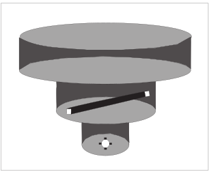
- Because of the heavy traffic volume and the procedures necessary to efficiently manage the flow of traffic, it has not been possible to incorporate VFR corridors in the development or modifications of Class B airspace in recent years.
- VFR Transition Routes
- To accommodate VFR traffic through terminal airspace, VFR Transition Routes were developed. A VFR Transition Route is defined as a specific flight course depicted and described on a TAC and/or VFR Flyway Planning Chart. Communication with ATC where the route transitions Class B, Class C, and/or Class D airspace is required. In addition to communication requirements, a clearance is required to operate in Class B airspace. VFR Transition Routes may include published altitudes or ATC‐assigned altitudes. Per 14 CFR section 91.123, pilot compliance is expected for all route and altitude restrictions as published or assigned by ATC. VFR Transition Route and altitude assignments do not relieve pilots from their duty to comply with 14 CFR section 91.119. Pilots are expected to request an alternate clearance if necessary for compliance.
- These routes, as depicted in FIG ENR 1.4-2, are designed to show the pilot where to position the aircraft where an ATC assignment or clearance for the route can normally be expected with minimal or no delay. Until ATC authorization is received, pilots must remain clear of Class B airspace. On initial contact, pilots should advise ATC of their position, altitude, route name desired, and direction of flight.
- For secondary airports underlying or in close proximity to Class B or Class C airspace, VFR Transition Routes may be developed and depicted for arrivals/departures. These arrivals/departures may be requested from or assigned by ATC.
FIG ENR 1.4-3VFR Transition Route 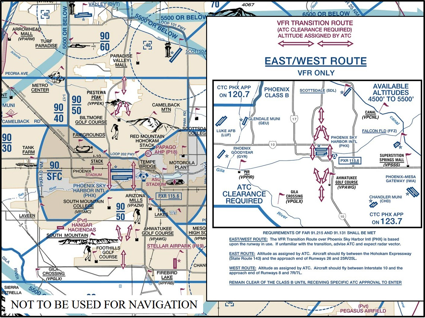
- Helicopter Routes
- Helicopter Routes are depicted on a specialized VFR chart established for select high traffic density areas to enhance helicopter access and ease of operation. The Helicopter Route Chart depicts prominent geographical features, roads and obstructions. A Helicopter Route is a specific VFR flight course and is depicted on the Helicopter Route Chart. These routes contain specific altitudes and instructions for navigating over visual reference points as published, or as instructed by ATC.
- Helicopter Route Charts, as depicted in FIG ENR 1.4-4, incorporate expanded ground reference and unique symbology to improve visual navigation. The charts contain additional information such as frequencies to self-announce on and other route information. On initial contact, pilots should advise ATC of their position, altitude, and route name desired. Helicopter Routes may include published altitudes or ATC‐assigned altitudes. Per 14 CFR section 91.123, pilot compliance is expected for all route and altitude restrictions as published or assigned by ATC. Helicopter Route and altitude assignments do not relieve pilots from their duty to comply with 14 CFR section 91.119 and 132.203(b). Pilots are expected to request an alternate clearance if necessary for compliance.
FIG ENR 1.4-4Helicopter Route Chart 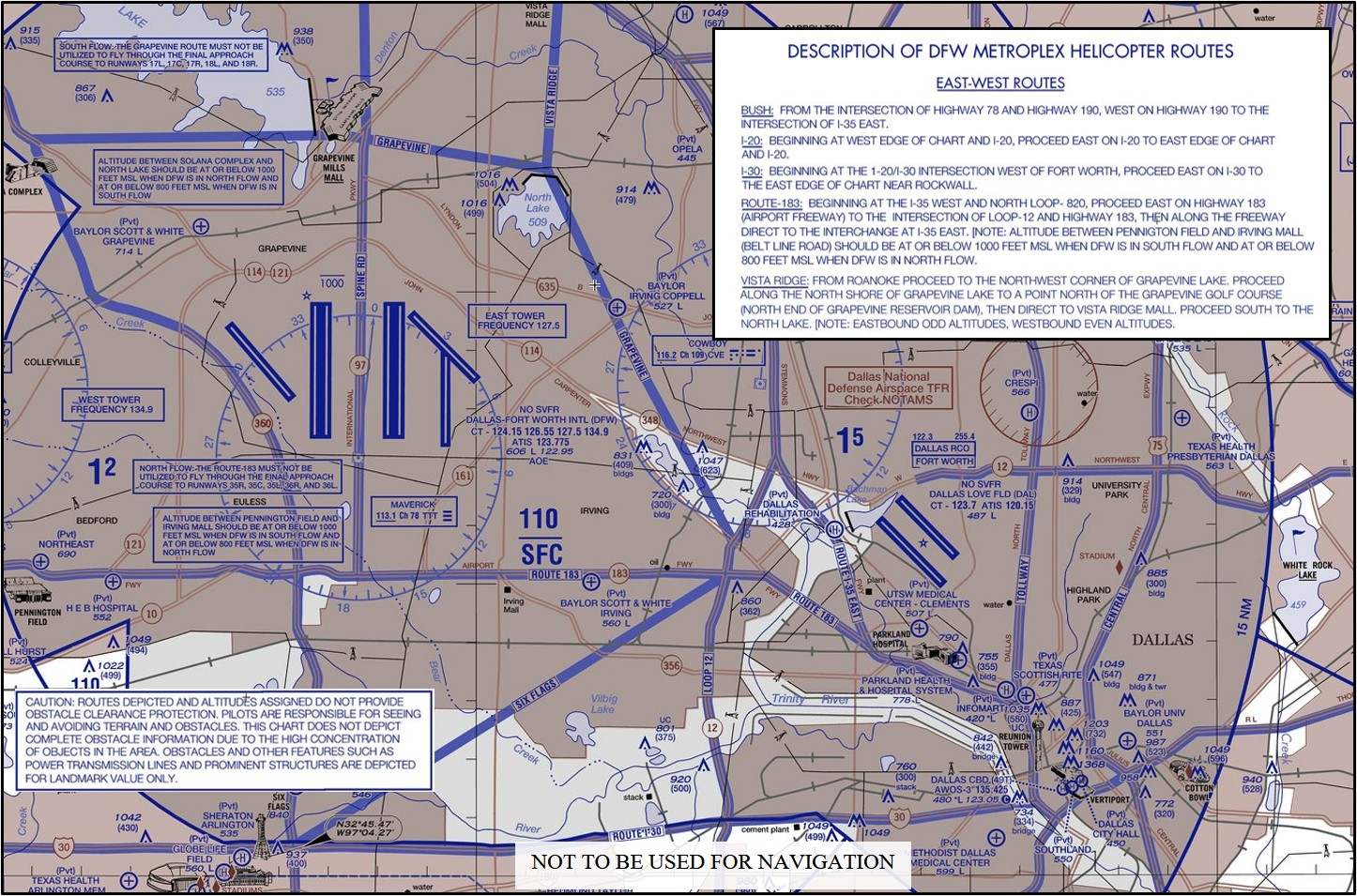
- VFR Flyways
- Terminal Radar Service Area (TRSA)
- Background. The terminal radar service areas (TRSA) were originally established as part of the Terminal Radar Program at selected airports. TRSAs were never controlled airspace from a regulatory standpoint because the establishment of TRSAs were never subject to the rulemaking process; consequently, TRSAs are not contained in 14 CFR Part 71 nor are there any TRSA operating rules in Part 91. Part of the Airport Radar Service Area (ARSA) program was to eventually replace all TRSAs. However, the ARSA requirements became relatively stringent, and it was subsequently decided that TRSAs would have to meet ARSA criteria before they would be converted. TRSAs do not fit into any of the U.S. Airspace Classes; therefore, they will continue to be non-Part 71 airspace areas where participating pilots can receive additional radar services which have been redefined as TRSA Service.
- TRSA Areas. The primary airport(s) within the TRSA become(s) Class D airspace. The remaining portion of the TRSA overlies other controlled airspace which is normally Class E airspace beginning at 700 or 1,200 feet and established to transition to/from the en route/terminal environment.
- Participation. Pilots operating under VFR are encouraged to contact the radar approach control and avail themselves of the TRSA Services. However, participation is voluntary on the part of the pilot. See ENR 1.1, paragraph 40.2, for details and procedures.
- Charts. TRSAs are depicted on VFR sectional and terminal area charts with a solid black line and altitudes for each segment. The Class D portion is charted with a blue segmented line.