ENR 4.4 Name-Code Designators for Significant Points
1.. Data Set
- The FAA provides aeronautical data via the following website: https://www.faa.gov/air_traffic/flight_info/aeronav/aero_data/.
2.. Alphanumeric Waypoints
- In addition to pronounceable five-letter name codes, the FAA uses alphanumeric designators for high en route waypoints as follows:
- Gulf of America Grid System, described in ENR 6.1.
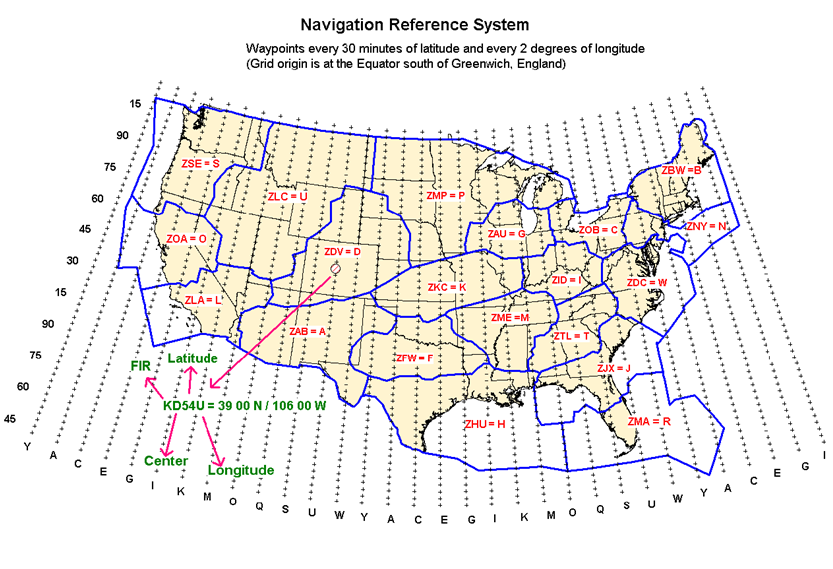
- National Reference System (NRS). The NRS is a grid of waypoints in the 48 contiguous United States and neighboring offshore airspace where the FAA provides air traffic services. These waypoints are published on the U.S. Government Flight Information Publication, IFR Enroute High Altitude – U.S. Charts. Waypoints are currently spaced every 30 minutes of latitude and every 2 degrees of longitude, and are assigned alphanumeric designators that begin with the letter “K.”
- The second character is an NRS letter code that denotes the High Air Route Traffic Control Center (ARTCC), per TBL ENR 4.4-1:
TBL ENR 4.4-1National Reference System (NRS) High ARTCC Code Listing High ARTCC
Location Identifier
NRS ARTCC Code
Albuquerque
ZAB
A
Atlanta
ZTL
T
Boston
ZBW
B
Chicago
ZAU
G
Cleveland
ZOB
C
Denver
ZDV
D
Fort Worth
ZFW
F
Houston
ZHU
H
Indianapolis
ZID
I
Jacksonville
ZJX
J
Kansas City
ZKC
K
Los Angeles
ZLA
L
Memphis
ZME
M
Miami
ZMA
R
Minneapolis
ZMP
P
New York
ZNY
N
Oakland
ZOA
O
Salt Lake City
ZLC
U
Seattle
ZSE
S
Washington
ZDC
W
- The third and fourth characters are numbers that denote the latitude. The latitude increment numbers start at the equator, which is designated “00.” Each 10-minute increment is then identified by a number between “01” and “90.” The latitude numbering sequence repeats each 15 degrees of latitude. TBL ENR 4.4-2 shows the third and fourth characters used by the FAA:
TBL ENR 4.4-2National Reference System (NRS) Third and Fourth Characters (Latitude) Used by the FAA 3rd and 4th Characters
Latitude
57
N 24° 30'
60
N 25° 00'
63
N 25° 30'
66
N 26° 00'
69
N 26° 30'
72
N 27° 00'
75
N 27° 30'
78
N 28° 00'
81
N 28° 30'
84
N 29° 00'
87
N 29° 30'
00
N 30° 00'
03
N 30° 30'
06
N 31° 00'
09
N 31° 30'
12
N 32° 00'
15
N 32° 30'
18
N 33° 00'
21
N 33° 30'
24
N 34° 00'
27
N 34° 30'
30
N 35° 00'
33
N 35° 30'
36
N 36° 00'
39
N 36° 30'
42
N 37° 00'
45
N 37° 30'
48
N 38° 00'
51
N 38° 30'
54
N 39° 00'
57
N 39° 30'
60
N 40° 00'
63
N 40° 30'
66
N 41° 00'
69
N 41° 30'
70
N 41° 40'
72
N 42° 00'
75
N 42° 30'
78
N 43° 00'
81
N 43° 30'
84
N 44° 00'
87
N 44° 30'
00
N 45° 00'
03
N 45° 30'
06
N 46° 00'
09
N 46° 30'
12
N 47° 00'
15
N 47° 30'
18
N 48° 00'
21
N 48° 30'
- The last character is a letter that denotes the longitude. The longitude letters start at the Greenwich meridian and go from west to east around the globe, repeating every 26 degrees. TBL ENR 4.4-3 shows the longitude letters used by the FAA:
TBL ENR 4.4-3National Reference System (NRS) Longitude Letters Used by FAA Letter
Longitude
Y
W 128°
A
W 126°
C
W 124°
E
W 122°
G
W 120°
I
W 118°
K
W 116°
M
W 114°
O
W 112°
Q
W 110°
S
W 108°
U
W 106°
W
W 104°
Y
W 102°
A
W 100°
C
W 98°
E
W 96°
G
W 94°
I
W 92°
K
W 90°
M
W 88°
O
W 86°
Q
W 84°
S
W 82°
U
W 80°
W
W 78°
Y
W 76°
A
W 74°
C
W 72°
E
W 70°
G
W 68°
I
W 66°
- Figure ENR 4.4-1 provides a graphical depiction of NRS naming:
FIG ENR 4.4-1National Reference System (NRS) Alphanumeric Code Depiction 
- The second character is an NRS letter code that denotes the High Air Route Traffic Control Center (ARTCC), per TBL ENR 4.4-1: