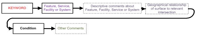
Section 2. Lighting Aid and Obstruction NOTAMs
FIG 5-2-1
Lighting Aids
…RWY 27 RTHL U/S…
Originate NOTAMs on operational status of lighting aids for certificated part 139 and civil public-use landing areas listed in the U.S. Chart Supplement. Each type of lighting requires separate NOTAMs. Technical Operations must be made aware of any runway approach lighting outages, as this is the office that maintains the equipment. When describing restrictions, use Runway Centerline (RCL) with visual navigational aids. NOTAMs regarding lighting aids are originated as follows:
- Commissioning
- Only use the runway direction for which the equipment pertains.
- When commissioning approach light systems, indicate the exact type of system (MALSR, MALSF, etc.). Once commissioned and published, approach light systems need only be shown as ALS.
- Runway edge lights (REDL). When commissioning runway edge light systems, indicate the exact type of system (LIRL, MIRL, HIRL, etc.). Once commissioned and published, runway edge lights must only be shown as REDL.
- Lead-in lights. Runway lead-in light system (RLLS).
- Approach light systems (ALS).
- ALS Outage
- Complete loss or dual mode with loss or unavailability of both ALS and SSALR capability.
- Dual mode with loss or unavailability of ALS capability only.
- When the ALS has been changed to the simplified, short ALS with runway alignment lights, issue the condition as temporarily changed (“NOW”). Do not use unserviceable (U/S).
- Sequence flashing light (SEQUENCED FLG LGT).
- One-thousand-foot bar (1000-FOOT BAR).
- Runway alignment indicator light (RAI LGT).
- Runway threshold light (RTHL).
NOTE-
Technical Operations issues RTHL, when associated with approach lighting systems (ALS).
- Visual approach lighting.
- Visual approach slope indicator (VASI).
- Precision approach path indicator (PAPI).
- Runway lighting.
- Runway status light system (RWY STATUS LGT SYSTEM).
- Take-off hold light (TKOF HOLD LGT).
- Runway entrance light (RWY ENTRANCE LGT).
NOTE-
NOTAM issued using keyword TWY.
- Runway end identifier light (RWY END ID LGT).
- Runway touchdown zone lights (RTZL).
- Runway centerline light (RCLL).
- Runway edge light. (REDL).
- Runway end light (RENL).
- Taxiway lighting.
- Taxiway centerline light.
- Taxiway edge light.
- Runway guard lights.
- Stop bar lights.
NOTE-
NOTAMs for guard lights and stop bar lights issued using keyword TWY.
- Lead off /lead on lights. NOTAMs issued using keyword RWY. Lead off and lead on light will be the standardized verbiage for lead off/on lights, which are also referred to as turnoff lights.
- Pilot−controlled lighting (PCL) frequency when it controls approach lights or runway lights.
- Airport lighting total power failure.
- Lights obscured due to snow and ice.
- Only issue a NOTAM when lighting is completely obscured (OBSC), do not report partial obscuration.
- Do not report reason for obscuration.
NOTE-
OBSC can be used to describe physical state of airport infrastructure, including signs and markings.
FIG 5-2-2
Obscured or Partially Obscured Runway Edge Lights
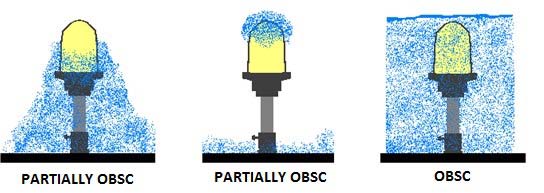
NOTE-
Lights that are partially obscured are not reported as a NOTAM.
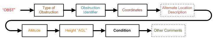
FIG 5-2-3
Obstacles
…OBST CRANE (ASN 20YY-ACE-5-NRA) 345140N0804506W (1.44NM SW N52) 580FT (195FT AGL) NOT LGTD…
See Appendix A for examples.
- Obstructions to include telecommunications antenna tower lights, cranes, stacks, wind turbines, non-FCC towers, power lines, moored balloon, kites, natural growth/terrain, etc.
- Any failure or malfunction which affects a top light or flashing obstacle light regardless of its position is a condition for a NOTAM.
- Commercial tower light operators must report the operating status of tower lights and ensure that a NOTAM is originated via a direct entry tool or contacting FSS.
- The NOTAM text for obstructions to air navigation must be formatted as follows 4-2-1 b 1-2, including:
- Location Identifier: For wind turbine farms, use the ARTCC under which the farm falls.
- Keyword “OBST.”
- Specify the attribute; for example, “TOWER LGT”, “CRANE,” “STACK,” “ACFT TAIL,” “BLDG,” “MOORED BALLOON”, “KITE” etc.
- Assigned obstruction identifier.
- For FCC Towers, the Antenna Structure Registration (ASR), if known, in parentheses. If the ASR is not known, indicate by (ASR UNKNOWN) in the NOTAM.
- For Cranes, Stacks, etc., the Aeronautical Study Number (ASN), if known, in parentheses. If the ASN is not known, indicate by (ASN UNKNOWN) in the NOTAM. Do not include the ASN for wind turbine farm NOTAMs, see examples.
- For Moored Balloon, which requires a waiver to 14 CFR Part 101, the assigned obstruction identifier is not required.
- For FCC Tower Obstructions, enter the location by latitude and longitude to the nearest one hundredth of a second. For wind turbine farms, if using latitude and longitude, provide the coordinates for the center point of the wind farm, or the coordinates for one of the turbines closest to the center. If the latitude and longitude is not known, use “UNKNOWN”. For all other obstacles, use the latitude and longitude to the nearest second, or fix/radial/distance, or a nautical mile radius of a NAVAID.
- Plain language location in parentheses.
- When the obstacle is within 5SM of an airport, describe the plain language location in feet or nautical miles using 16 points of compass from a specified location on the airport; for example, (.5NM E APCH END RWY 18) (2000FT SSE DEP END RWY 20) (2NM SSW ACY).
- When the obstacle is within 500 feet either side of the centerline of a charted helicopter route, or 5SM or more from an airport and more than 200 feet AGL, describe the plain language location by using the bearing, distance, and aerodrome designator of the nearest public-use airport; for example, (12NM SSW SPA).
- Specify the altitude MSL with the unit of measurement (FT), if known. Otherwise state UNKNOWN. For wind turbine farms, use the tallest height of a turbine within the farm.
-
In parentheses, specify the height with the unit of measurement (FT) and reference indication label (AGL).
NOTE−
Report the height of obstruction lights on terrain (hills) in MSL only, as the terrain is the obstacle, not the light on the terrain. - Specify the condition:
- “U/S” for FCC obstructions. A light condition of unserviceable refers to a top light or flashing obstruction light is not operating, regardless of its position.
- “NOT LGTD,” “LGTD,” “FLAGGED” for non-FCC obstructions, for example, cranes.
NOTE-
For wind turbine farms, use “LGT U/S”.
- Start of Activity/End of Validity.
- FCC receives notification only upon ASR NOTAM issuance.
- Cranes. Schedule (when needed).
- OBST NOTAMs must not be issued as PERM, unless initiated by those associated with the obstacle publication process. To initiate the publication process of obstacles, contact the FAA Obstacle Data Team at 9-ajv-532-obstdata-req@faa.gov.