Section 1. Airspace
FIG 6-1-1
Airspace
…AIRSPACE CRYPT NORTH MOA AND REVEILLE MOA ACT 5000FT-16000FT…
- NOTAMs originated for Airspace items will be formatted following 4-2-1 b 1-2, including:
- Location identifier.
- Use nearest public use airport when the full activity is completely within a 5 NM radius of the airport.
- Use nearest VOR when any of the activity is more than 5 NM from the nearest public use airport but completely within 25 NM radius of a VOR.
- Use the ARTCC when the activity doesn't fall within either (a) or (b).
- Keyword “AIRSPACE.”
- Description of activity, if needed.
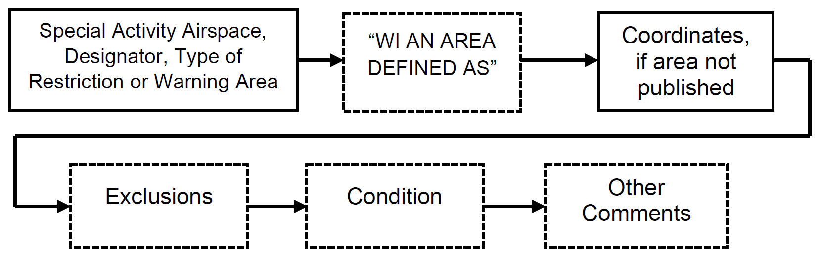
- Description of area impacted; for example, the name of a published area, an airport, a nautical mile radius of a latitude/longitude, NAVAID or fix-radial-distance from a VOR-type NAVAID, or an area defined by latitude/longitude or NAVAID. When applicable, preface the description with this standard phrase: “WI AN AREA DEFINED AS…”
- Plain Language location, when using all latitude/longitude, except Central Altitude Reservation Function (CARF) and surveillance broadcast systems (SBS)-type NOTAMs. In parentheses, specify using nautical miles…direction…airport (5NM E IAD), or F/R/D from the nearest NAVAID.
- Condition.
- Lower limit/upper limit; for example, 5000FT-16000FT (as specified in 4-2-1).
- Remarks (when needed). Other operational information.
- When identifying the expected height of a balloon trajectory, express it in FT, 150000FT.
- Identifying the frequency transmitting on is an acceptable remark.
- Certificate of Authority, when requested by the proponent.
- Follow 4-2-1 b 13-14 to complete the NOTAM.
TBL 6-1-1
Types of Activity
|
AIRSHOW ACFT |
AEROBATIC AREA |
PJE |
|
DEMONSTRATION ACFT |
HOT AIR BALLOON |
UNMANNED FREE |
|
UNMANNED ROCKET |
UAS |
GLD |
|
HANG GLD |
LGT OUT TRG |
BALLOON LDG |
|
PYROTECHNIC |
BLASTING |
CONTROLLED BURN |
|
AEROBATIC ACFT |
SPACE LAUNCH |
SPACE REENTRY |
NOTE-
Airspace activities that will require airspace management such as Temporary Flight Restrictions will require the issuance of an FDC NOTAM.
A NOTAM must be entered through Special Use Airspace Management System to activate permanent or temporary special use airspace if activated by NOTAM only or at other than published times for those SAA that contain a NOTAM provision in their legal description, under the appropriate ARTCC(s):
- SAA, for the purpose of this manual, includes Special Use Airspace (SUA) (restricted area, military operations area (MOA), warning area, and alert area airspace), instrument and visual military training routes, aerial refueling tracks and anchors.
NOTE-
Controlled Firing Area (CFA) does not require a NOTAM as the activity is suspended immediately when a nonparticipating aircraft approaches the area.
REFERENCE-
FAA Order JO 7400.2, Procedures for Handling Airspace Matters.
- A NOTAM must be in effect to activate SAA at other than published or charted times for those areas that contain a NOTAM provision (“BY NOTAM,” “INTERMITTENT BY NOTAM,” or “OTHER TIMES BY NOTAM”) in their times of use legal description per FAA Order JO 7400.10, Special Use Airspace, Flight Information Publications, and related Government charting products, or if that SAA can only be activated by NOTAM. A NOTAM must not be used to make other changes to the charted lateral dimensions or which would exceed the lower or upper published altitude limits.
- NOTAMs for SAA activation and cancellation for uncharted and unpublished times must be originated by the appropriate controlling agency, with the overlying ARTCC as the location identifier, using the appropriate accountability of SUAE, SUAC and SUAW, corresponding to the FAA service areas, east, central and west, respectively.
- Issue the NOTAM in the format described in 6-1-1 above using the following items:
- Accountability = SUA (E, C, W)
- Location Identifier = ARTCC
- Condition = ACT (active)
- Lights Out/Night Vision Goggle Operations in MOAs. Upon notification of a lights out/ Night Vision Goggle operation in an authorized MOA (as listed in FAA exemption 7960 and FAA exemption 3946), issue a NOTAM containing the description of activity information.
- SUA NOTAMs are originated by the controlling agency, utilizing the SUA Management System. The type of activity included does not restrict movement into or out of the airspace. TFRs restrict movement. This is an advisory about unusual activity within the airspace. Do not use this to report increased flight movement.
- Central Altitude Reservation Function (CARF) airspace and altitude reservation NOTAMs must be transmitted by the USNOF, after receipt of the proposed NOTAM from the CARF office or ARTCC. The information will be stored in the NS database and available for request/reply. If the altitude reservation affects international airspace, it will be sent and stored as an international NOTAM.
NOTE-
Commercial space operations are examples of activity permitted in ALTRVs within oceanic and offshore airspace
- Accountability = CARF Location identifier
- Location Identifier = ARTCC
- Description of Activity = STNR ALT RESERVATION
- Airspace and Altitude reservation involving a single ARTCC.
- Missile firing and offshore airspace reservations. ARTCCs must issue as a NOTAM missile firing exercises and offshore airspace reservations. These NOTAMs must be transmitted as an international NOTAM to the USNOF.
- Weather Reconnaissance Area (WRA). A WRA is established to support weather reconnaissance/research flights. ARTCCs must use the CARF accountability location identifier when issuing NOTAMs for a WRA.
- Where published tracks/anchors are inadequate for special mission/sortie, special track/anchor may be established. Special tracks/anchors must not be published in the DOD Flight Information Publications (FLIP) Planning document but may be described in Letters of Agreement.
- NOTAM Ds will be used for special refueling tracks/anchors outside Class A airspace so as to define the refueling area as specifically as mission security will allow.
- Issue the NOTAM in the format described in 6-1-1a above with:
REFERENCE-
FAA Order JO 7610.14, Para 5-6-6, Special Exercises.
FAA Order JO 7610.14, Para 5-6-7, Issue NOTAM.
- When required, originate an airspace activity NOTAM only for the time period the activity is taking place. When the activity is expected to be temporary but of long duration (more than three months) or permanent, the information must be published in the appropriate chart/publication. Once the information is published, the NOTAM must be canceled unless required by a Certificate of Waiver or Authorization from Title 14, Code of Federal Regulations (CFR) issued by the FAA.
- FAA Authorization will consist of an approved waiver/authorization to 14 CFR. Upon receipt of appropriate notification/authorization, but not more than 7 days prior to the event, originate an AIRSPACE NOTAM using the format described in 6-1-1a above, ensuring not to advertise published or charted data and information.
- Ensure the NOTAM originator is aware that authorizations, waivers, and/or air traffic notifications may be required by the proponent, and the proponent's information is not released in the NOTAM but must be made available immediately upon request to ATO and other entities responsible for airspace deconfliction for the following activities:
- Airshows, aerial demonstrations, aerobatic areas, hot air balloon events, flight test areas, light out training, banner towing.
- FAA authorization will consist of a waiver to 14 CFR part 91.
- Obtain the following information from the requestor:
- Name, address, and telephone number of the person giving notice.
- Identification and type of the aircraft to be used.
- Moored balloons, kites, amateur rockets, unmanned free balloons.
- FAA authorization will consist of a waiver to 14 CFR part 101.
- Obtain the following information from the requestor: Name, address, and telephone number of the person requesting authorization or giving notice.
NOTE-
Unmanned rocket activities that will require airspace management such as Temporary Flight Restrictions will require the issuance of an FDC NOTAM.
- Parachute Jumping/Sky Diving
- FAA authorization/air traffic notification will be required under 14 CFR part 105.
- Obtain the following information from the requestor
- Name, address, and telephone number of the person requesting authorization or giving notice.
- Identification of the aircraft to be used
- Unmanned Aircraft Operations
- FAA authorization will consist of a Certificate of Authorization, Certificate of Waiver or an Airspace Authorization documented on an FAA Form 7711-1-Certificate of Waiver or Authorization.
- NOTAM is not required for UAS operations, unless specifically stated on the FAA Form 7711-1 - Certificate of Waiver or Authorization, Special Airworthiness, or similar document.
- In general, a NOTAM is not required for UAS operations in Class A airspace.
- In general, a NOTAM is not required for UAS operating as follows:
- at or below 400' above ground level (AGL), in Class G airspace, or at or below the established UAS facility map altitudes in Class B, C, D and E surface area, and
- UAS weighs less than 55 lbs., and
- remaining within visual line of sight, and
- have a maximum airspeed of 100 mph (87 knots) or less.
Originate an AIRSPACE NOTAM using the format described in 6-1-1a above.
- A NOTAM D may be originated for permanent changes to part time surface area hours of operation only, under the following conditions:
- The change in the surface area hours of operation is due to other than seasonal daylight time changes.
- Only those surface areas identified as part time in the airspace section of the U.S. Chart Supplement as part time are subject to change by NOTAM. A continuous surface area “hours of operation” is changed only through rulemaking action.
- The change in the surface area hours of operation will thereafter be continuously published in the U.S. flight information publication, Chart Supplement Alaska, Chart Supplement Pacific, or the Chart Supplement U.S.
NOTE-
NOTAM specifying or changing the dates and times of a designated part time surface area must coincide with issuance of a corresponding Hours of Operation Services NOTAM and may be issued by the appropriate facility only after coordination with the regional/service area office.
- For temporary changes to published part time surface area hours of operation, issue a Services NOTAM (SVC) in accordance with paragraph 5-5-3, Hours of Operation. Do not issue an Airspace NOTAM.
The graphs below depict the commonly used airspace areas.
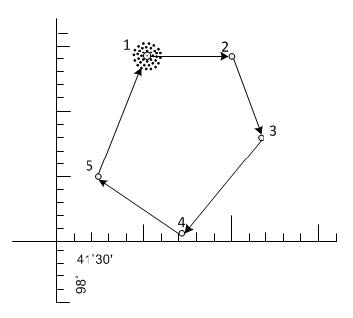
- Polygon. Points defining lateral limits of an area must be enumerated in clockwise order. The last and the first points of the list must be the same (TO POINT OF ORIGIN). Latitude/longitude must be followed by plain language location between parentheses.
FIG 6-1-2
Polygon
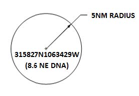
- Circle. Define a circular shape as “WI AN AREA DEFINED AS XNM RADIUS” followed by the location of the center of the circle
FIG 6-1-3
Circle
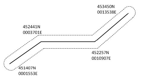
- Corridor. A corridor is a type of polygon defined by a line between points and a lateral distance on either side of the line. The lateral limits are at the end points connected by arcs of circle.
FIG 6-1-4
Corridor