GEN 2.1: Measuring System, Time System, and Aircraft Markings
1. Units of Measurement
1.1 The following table identifies the units of measurement that have been selected for use in messages transmitted by all U.S. aeronautical stations, in the U.S. AIP, NOTAM dissemination, and other publications.
2. Time System
2.1 Coordinated Universal Time (UTC) is used in the Air Traffic and Communication services provided and in most documents published by the Aeronautical Information Services.
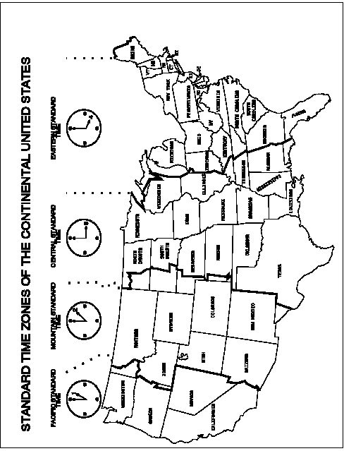
2.2 When local mean time is used, it will be so indicated as local standard time (LST). See FIG GEN 2.1-1 for a depiction of the standard time zones within the continental U.S.
3. Geodetic Reference Datum
3.1 All published geographic coordinates indicating latitude and longitude are expressed in terms of the World Geodetic System - 1984 (WGS-84) geodetic reference datum.
4. Nationality and Registration Marks
4.1 The nationality mark for the aircraft registered in the U.S. is the letter N, followed by a series of numbers or a series of numbers and letters.
TBL GEN 2.1-1
|
For Measurements of: |
Units used: |
|
Distance used in navigation, position reporting, etc. - generally in excess of 2 to 3 nautical miles |
Nautical miles and tenths |
|
Relatively short distances such as those relating to aerodrome (e.g., runway lengths) |
Feet |
|
Altitudes, elevations and heights |
Feet |
|
Horizontal speed, including wind speed |
Knots |
|
Vertical speed |
Feet per minute |
|
Wind direction for landing and taking off |
Degrees magnetic |
|
Wind direction except for landing and taking off |
Degrees true |
|
Visibility, including runway visual |
Statute miles or feet |
|
Altimeter Setting |
Inches of mercury |
|
Temperature |
Degrees Fahrenheit |
|
Weight |
Pounds |
|
Time |
Hours and minutes, the day of 24 hours beginning at midnight Coordinated Universal Time |
