Chapter 5. Aerial Refueling
Section 3. Anchor Requirements
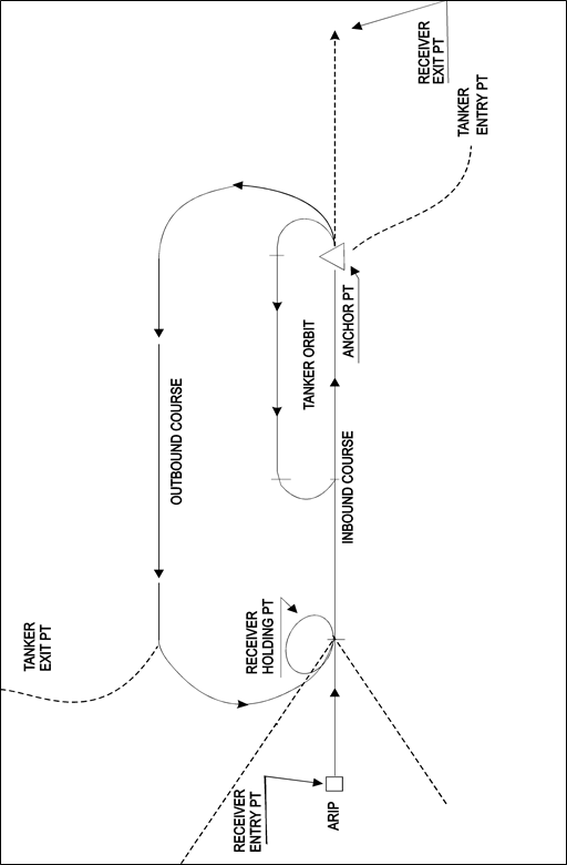
5-3-1. DESCRIPTION
- The standard aerial refueling anchor track consists of a left-hand race track orbit with legs at least 50 NM in length. The legs will normally be separated by at least 20 NM. The orientation of the track is determined based on the inbound course to the anchor point. Four turn points are designated to describe the anchor track. (See FIG 5-3-1.)
- The standard anchor area consists of one or more entry points, an ARIP, anchor point, anchor track turn points, one or more exit points, and the designated refueling altitude block(s).
- Instructions for preparing and submitting anchor proposals are contained in section 4 of this chapter.
5-3-2. NAVIGATION WITHIN ANCHOR AREA
Anchor refueling must take place along the published anchor track unless otherwise coordinated with the ARTCC/CCF/HCF or through a letter of agreement with the controlling agency. Navigation must be accomplished predicated on one of the following:
5-3-3. ARIP ESTABLISHMENT
The anchor ARIP must be established:
- Normally, a minimum of 70 NM from the anchor point and within 30 degrees either side of the extended anchor point leg at the uptrack end of the anchor track.
- So as to provide for straight-line navigation from the ARIP to the anchor point leg at the uptrack end of the anchor track.
5-3-4. DEGREE*DISTANCE ANCHOR DEFINITION
Anchors predicated on degree-distance definition must provide:
- A means of navigation from the anchor ARIP to the anchor point via a usable NAVAID radial/distance.
- A means of navigation from the exit point of the anchor area to proceed IFR en route via a usable NAVAID.
- Anchor areas located over water or in remote areas or beyond the range of fixed NAVAIDs must be predicated on geographical coordinate route definition with suitable navigation means provided by the user command.
FIG 5-3-1Anchor Track