Chapter 6. Military Training Routes (MTR)
Section 5. IR Coordination
6-5-1. ESTABLISHING OR REVISING IR ROUTES
- Military units having a requirement to establish or revise a route must have that requirement validated by the appropriate military major/type command. As a part of the validation process, a determination must be made that other alternatives have been explored (e.g., use of existing MOAs, restricted areas, or other routes). This determination must be documented in writing and become a part of the route proposal.
- All route requests or route amendments developed by the originating unit must be submitted on FAA Form 7110-4 (see FIG 6-5-2 for sample form). A letter of transmittal must contain sufficient information to allow each reviewing authority to adequately understand and evaluate the proposal/revision. For route revisions, complete FAA Form 7110-4 with only the changed/new data, route designation, and originating activity. Select “Modify” in the Action box.
- All route proposals must be illustrated on a current sectional chart (not required for revisions that do not effect route alignment) with routes depicted as follows:
- Routes must be depicted by lines defining the route widths.
- Altitudes must be depicted along each route segment and expressed in hundreds of feet AGL or MSL as appropriate. Altitude blocks or ranges must be indicated by separating the altitudes with a “B” for blocks or a dash “-” for ranges. (Refer to paragraph 6-4-3, Altitudes.)
- Each point/fix, including turn points, must be identified in degrees, minutes, and seconds to the nearest tenth of a second, by sequential alphabetical lettering in accordance with the direction of flight.
- The originating unit must coordinate the route proposal with other affected military organizations.
- The ARTCC/CCF/HCF in whose area the route originates must be the focal point and coordinate with other ATC facilities.
- A listing of all personnel and organizations coordinated with must become a part of the route proposal.
- Once the ARTCC/CCF/HCF has concurred with an IR proposal, subsequent changes must be re-coordinated with the ARTCC/CCF/HCF and documented regardless of the level at which the change was made.
- Prior to submission for publication, the military must conduct an operational flight evaluation of the entire route to ensure compatibility with obstacle clearance, navigation, communication, and special restriction requirements. Coordination with the appropriate ATC facilities is required.
- Once ARTCC/CCF/HCF proponent agreement has been reached, proposals must be forwarded to the appropriate military major/type command headquarters for review and environmental certification.
- If agreement between the proponent and the ATC facilities involved cannot be achieved after consideration of all feasible alternatives and compromises, the proponent must request assistance from the appropriate military headquarters and the FAA Service Area military representative. A resolution must then be sought at a meeting attended by the proponent, the ATC facilities involved, military major/type command headquarters representatives, the FAA Service Area, and the military representatives. Should a resolution not be achieved, the military headquarters representatives may authorize the proponent to proceed with processing of a VR proposal in lieu of the disagreed IR.
- FAAService Area Review action: IR proposals must be forwarded to the military representative at the FAA Service Area in which the routes originate. The IR proposal(s) must include copies of all environmental documentation supporting the proposal and the major/type command headquarters' environmental certification addressed in paragraph 6-5-1.i. above. The military representative must review the proposals for compliance with this criteria, coordinate with other military service representatives, and then submit them to the FAA Service Area office.
- The FAA Service Area must:
- Coordinate all proposals with other interested FAA Service Units.
- Determine when proposals will increase the burden on civil users of the navigable airspace, and coordinate those proposals with the appropriate civil aviation user groups.
- Approve or disapprove the proposal and notify the Service Area military representative, in writing, within 45 days of receipt of the original proposal.
- The FAA Service Area office is the final approval authority for all IR proposals/revisions.
- The block diagram below represents the normal coordination flow of a proposed IR.
FIG 6-5-1Normal Coordination Flow of a Proposed IR 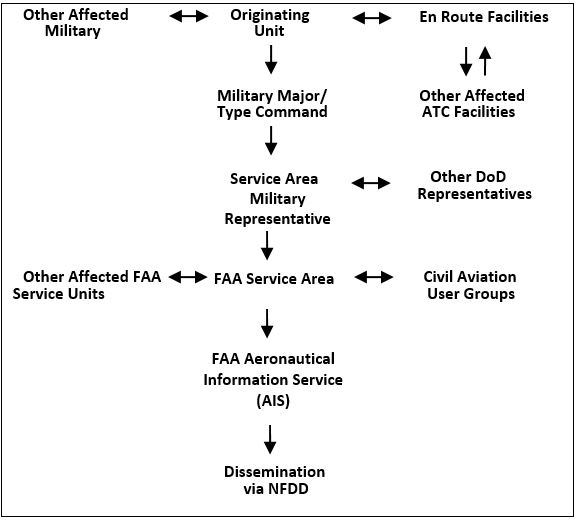
6-5-2. PUBLICATION
- The FAA Service Area office in whose area the route originates must submit the approved FAA Form 7110-4 containing the route descriptive data to FAA Aeronautical Information Services (AIS), Aeronautical Data website at https://www.faa.gov/air_traffic/flight_info/aeronav/aero_data/, at least 58 days prior to the requested/required airspace effective date. Send a copy to the appropriate Service Area military representative.
- AIS must issue the official, complete route description via the National Flight Data Digest (NFDD). It must be published in the same format as FAA Form 7110-4.
- The DoD FLIP Area Planning booklets, AP/1B or AP/3, as appropriate, must be the official source of MTR descriptions for military users. It must be published in the same format as FAA Form 7110-4.
- ARTCC/CCF/HCFs must review IR data published in the NFDD for accuracy and inform the appropriate FAA Service Area office whenever a disparity exists between that which was agreed to and that which was published.
- The military is responsible for submitting IR data for publication in the DoD FLIP AP/1B booklet in accordance with DoD FLIP GP, Chapter 11. Military originating activities must review IR data published in the DoD FLIP AP/1B and AP/3 booklets and charts for accuracy and inform the appropriate Service Area military representative whenever a disparity exists between that which was submitted and that which was published.
- Military originating activities and ARTCC/CCF/HCFs must ensure that IR data published in the DoD FLIP AP/1B and AP/3 booklets correlate with provisions contained in the letters of agreement governing the use of the route.
6-5-3. EFFECTIVE DATE
- New routes are effective upon the Aeronautical Information Regulation and Control (AIRAC) date published in the National Flight Data Digest (NFDD) and the DoD FLIP Area Planning booklets, AP/1B or AP/3, as appropriate.
- Revisions to existing routes are effective upon the AIRAC date published in the NFDD and the DoD FLIP Area Planning booklets, AP/1B or AP/3, and issued as a Flight Data Center (FDC) NOTAM.
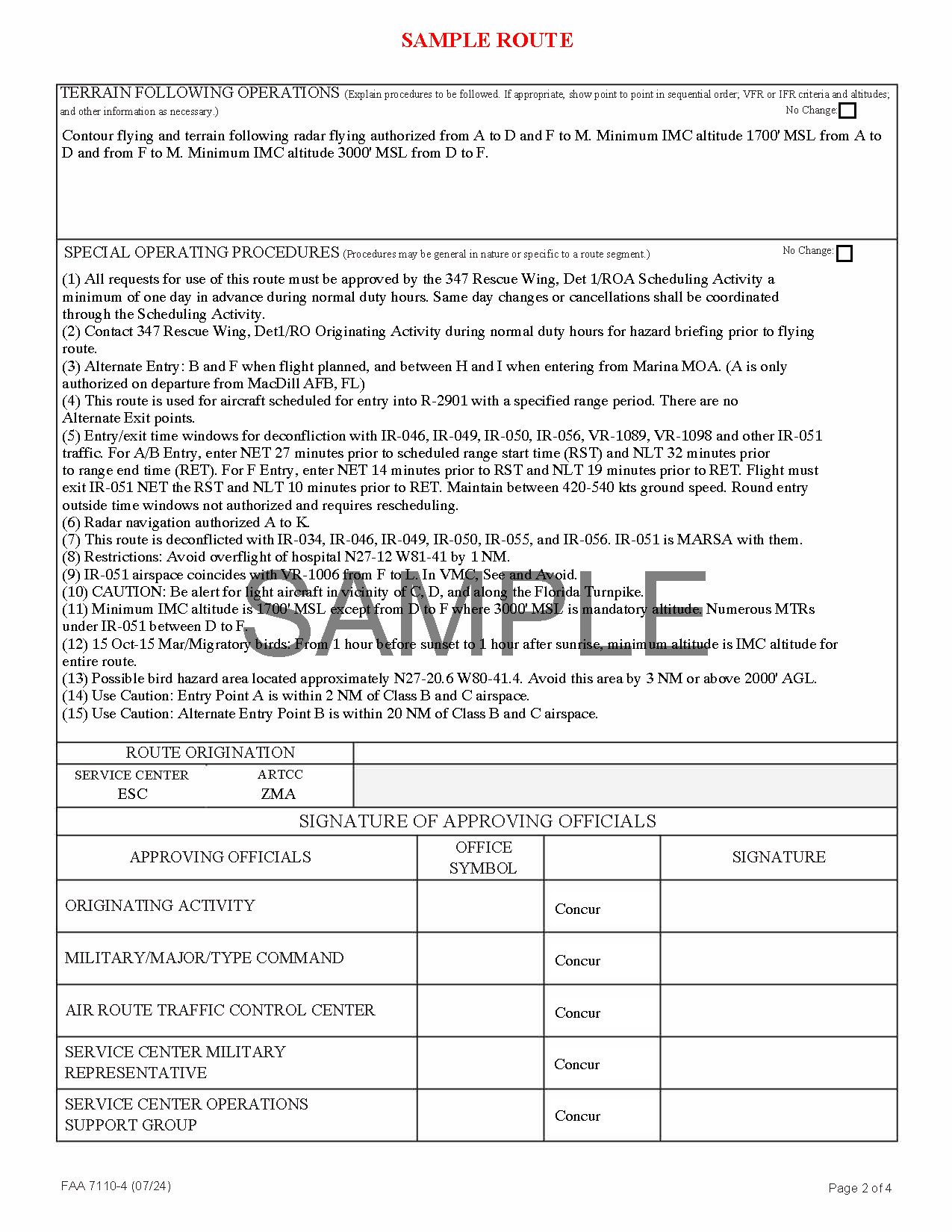
This form must be completed by federal government employees only.
FIG 6-5-2 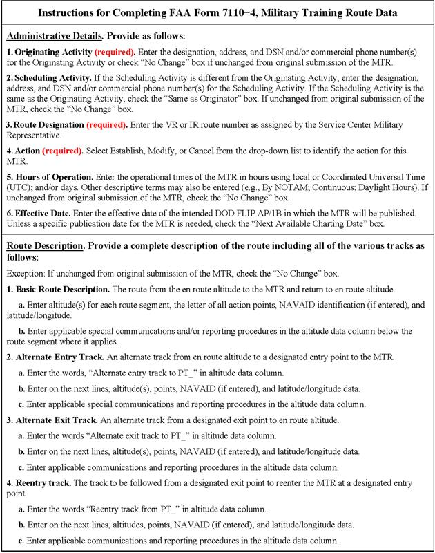
FIG 6-5-3 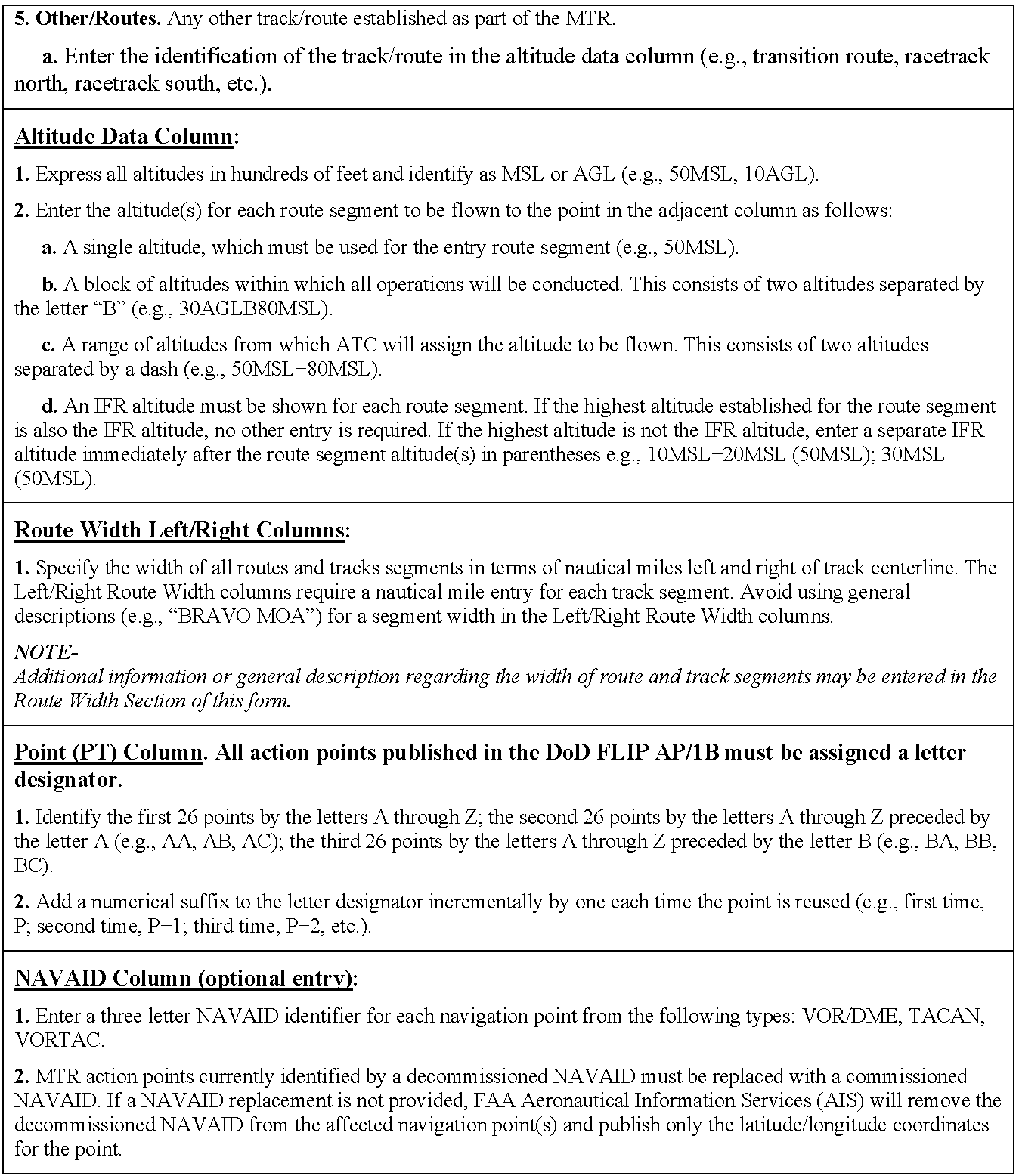
FIG 6-5-4 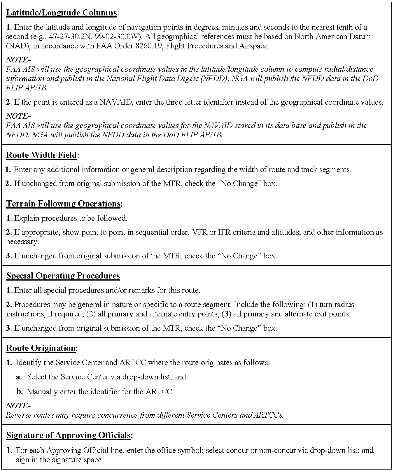
FIG 6-5-2 ContinuedFAA Form 7110-4, Military Training Route Data - SAMPLE ROUTE This form must be completed by federal government employees only. 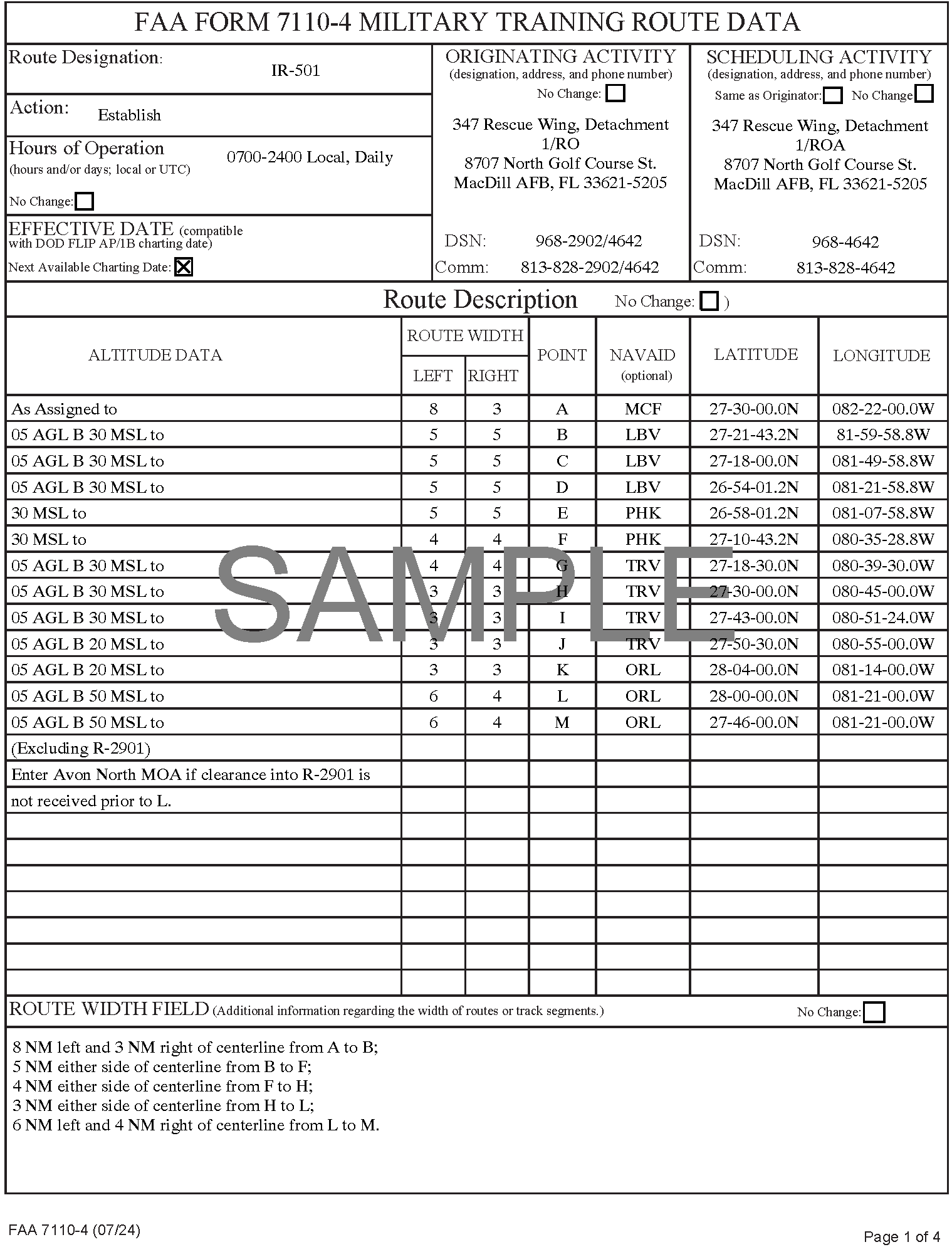
FIG 6-5-6