Chapter 5. Aerial Refueling
Section 4. Planning
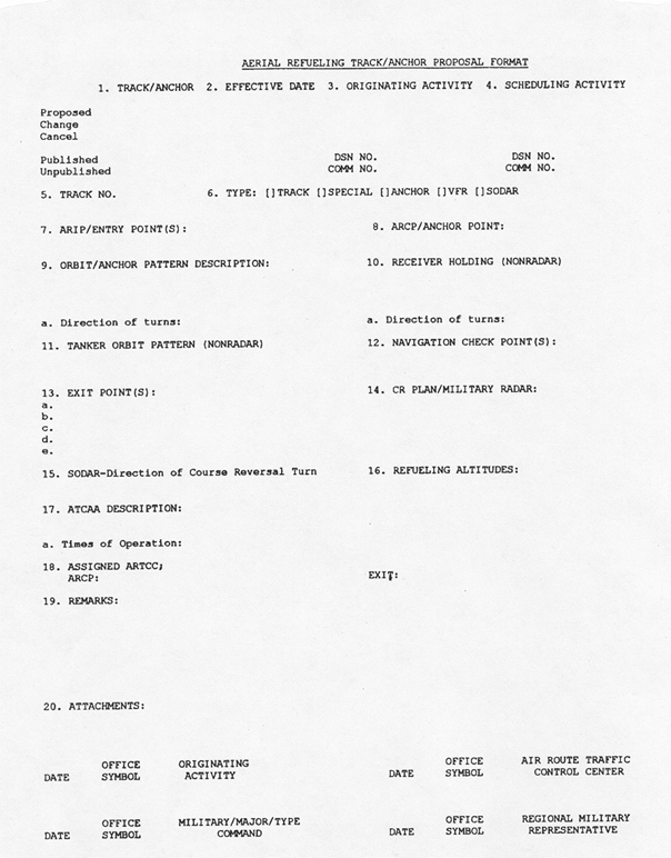
5-4-1. TRACK/ANCHOR PROPOSALS
Proposals for establishing refueling tracks or anchors must be submitted in the format and with the data depicted in FIG 5-4-1 to the appropriate ARTCC/CCF/HCF with a copy to the appropriate Service Area military representative.
5-4-2. COORDINATION
- The ARTCC that received the request for establishment of an aerial refueling track or anchor must assume the responsibility for FAA internal coordination, as necessary.
- In the event the proposed track/anchor lies within special use airspace (SUA) or ATC assigned airspace (ATCAA), the using agency, if different from the requesting unit, must provide written assurances to the appropriate FAA office that aerial refueling operations will not conflict with other activities being conducted. Correspondence accompanying the initial proposal for refueling track/anchor must include the written assurance.
5-4-3. CRITERIA FOR ESTABLISHMENT
- Aerial refueling tracks may be established for use in either direction in sufficient length to satisfy the mission requirement.
- Parallel tracks may be established provided a minimum of 30 NM exist between track centerlines.
- Tracks/anchors may be established coincident with, parallel to, or across airways/jet routes as considered appropriate by the ATC facility with airspace jurisdiction.
- Tracks/anchors must be defined in relation to NAVAIDs by degree-distance reference or by geographical coordinates.
- Where anchors are established inside SUA or ATCAAs, entry and exit points must be located on the boundary of the SUA or ATCAA for use as transfer of flight data information points, unless alternate entry and exit points are authorized by ATC.
- The scheduling agency for the ATCAA must ensure that pilots comply with the procedures in the applicable LOA.
- The receiver entry point (track/anchor) will be the ARIP.
- The tanker entry point (track/anchor) will be the ARCP/anchor point and should be located to permit direct routing.
- The following is guidance for establishing simultaneous opposite direction aerial refueling (SODAR):
- Simultaneous refueling in opposite direction may be authorized between single AR tracks, which are vertically separated by a minimum of 2,000 feet between altitude blocks.
- If it becomes necessary to assign SODAR aircraft altitude blocks which are outside the vertical limits of the AR tracks, controllers must ensure a vertical separation minimum of 2,000 feet between assigned altitude blocks.
- The SODAR procedure is not intended to apply to all refueling tracks (due to airspace configuration, traffic volume, etc.), however, the appropriate ARTCCs/CCFs/HCFs are expected to evaluate existing tracks for feasibility upon user request.
- If an existing single AR track qualifies for SODAR, it may be split into two separate tracks, or a new track may be created directly above or directly below the existing track. In either case, the tracks must be vertically separated by 2,000 feet and each track must be designated by a separate number.
- Each published track description must contain, in remarks, that it is authorized for simultaneous opposite direction aerial refueling (i.e., “SODAR authorized with AR___”).
- SODAR tracks should be established for bi-directional use to permit course reversals without requiring altitude changes.
5-4-4. APPROVAL NOTIFICATION
After receiving concurrence from all impacted ARTCCs/CCFs/HCFs for an aerial refueling track or anchor, the ARTCC/CCF/HCF in which the AR track is initiated must forward the Aerial Refueling Track/Anchor Proposal (See FIG 5-4-1). This includes all information required in FIG 5-4-1 and any other pertinent information to the appropriate air traffic Service Area office and military representatives.
5-4-5. PUBLICATION IN FLIP
After final coordination the military representative assigned to the FAA Service Area office must forward the following information to the National Geospatial-Intelligence Agency (NGA) for publication:
- For tracks:
- Number - The originator of the track/anchor must obtain a route designator for use during coordination from NGA Aeronautical Help Desk via telephone (DSN 846-1636 or commercial 1-877-817-9134) or email (aerohelp@nga.mil) The number in the designator provided by NGA will be prefixed by an “X”; for example, AR-X100, to indicate the number to be used for coordination purposes only. The prefix “X” will be deleted when published in FLIP Planning.
- ARIP - Degree-distance or coordinate values.
- ARCP - Degree-distance or coordinate values.
- Navigation check points - Degree-distance or coordinate values.
- Exit point - Degree-distance or coordinate values.
- Communications/Rendezvous Plan – Obtain from 618 AOC/XOPM, 402 Scott Dr., Unit 2K1, Scott AFB, Illinois 62225 (commercial (618) 256-8511 or DSN 576-8511) by the Service Area military representative if required.
- Refueling altitudes.
- Scheduling unit.
- Assigned ATC facility.
- Remarks including the list of coordination accomplished.
- For anchors:
- Number - Same procedures as in subparagraph a1.
- Description of anchor area - Coordinates.
- Entry point(s) - Degree-distance or coordinate values.
- ARIP(s) - Degree-distance or coordinate values.
- Exit - Degree-distance or coordinate values.
- Anchor pattern (four turn points) - Degree-distance or coordinate values.
- Exit point(s) - Degree-distance or coordinate values.
- Communications/Rendezvous Plan – Obtain from 618 AOC/XOPM, 402 Scott Dr., Unit 2K1, Scott AFB, Illinois 62225 (commercial (618) 256-8511 or DSN 576-8511) by the Service Area military representative if required.
- Military radar unit (MRU) call sign and MHz frequencies.
- Refueling altitudes.
- Scheduling unit.
- Assigned ATC facility.
- Operational time.
- Remarks, including anchor point, inbound course, pattern width, pattern length, and the list of coordination accomplished.
- State whether ATCAA is associated with anchor and list the scheduling agency for the ATCAA.
5-4-6. MILITARY SERVICE AREA REPRESENTATIVE RESPONSIBILITIES
- Ensure that all appropriate DoD and FAA coordination has been accomplished.
- Obtain a Communications Rendezvous Plan (C/R Plan) from 618 AOC/XOPM, 402 Scott Dr., Unit 2K1, Scott AFB, Illinois 62225 (commercial (618) 256-8511 or DSN 576-8511) by the Service Area military representative if necessary, and submit the information required in paragraph 6-4-5, Publication in FLIP, to NGA. The USN regional representative must submit data to Naval Flight Information Group, Washington Navy Yard, Bldg. 176, 901 M Street SE, Washington, DC 20374-5088.
- Maintain a master list of all current refueling tracks and anchors (both published and special) that fall within this area of responsibility, scheduling units, and assigned ATC facilities.
- Ensure that the concerned ATC facilities are aware of the effective date of the track or anchor and any revisions thereto.
5-4-7. NGA RESPONSIBILITIES
- Assign track and anchor numbers and provide them to the originator upon request. Each published track or anchor must be identified by the prefix “AR” followed by a number. Numbers must be assigned consecutively in their particular group.
- Should the track or anchor be outside Class A airspace areas, submit the following information directly to the FAA Aeronautical Information Services (AIS), Aeronautical Data website at https://www.faa.gov/air_traffic/flight_info/aeronav/aero_data/ for publication on appropriate charts (by AIS) and assume responsibility for updating it as necessary.
- Designated track or anchor number.
- Geographical location of the track or anchor using NAVAID degree-distance definitions or geographical coordinates.
- Location (State).
- Track beginning.
- Track end.
- Altitudes.
5-4-8. EFFECTIVE DATE
Aerial refueling tracks and anchors and revisions thereto must be effective upon the date of the DoD FLIP document publication.
5-4-9. REVISIONS TO TRACKS/ANCHORS
Revisions must be processed in the same manner as new proposals.