
Lockheed L-1049 Super Constellation and Douglas DC-7
Trans World Airlines Flight 2, N6902C
United Airlines Flight 718, N6324C
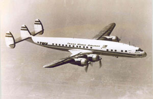
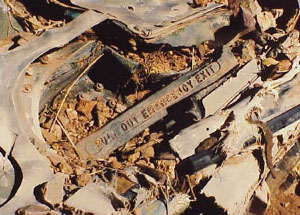
Photo copyright Michael Haywood - used with permission
Grand Canyon, Arizona
June 30, 1956
On the morning of June 30, 1956, TWA Flight 2, a Lockheed Super Constellation, collided with United Air Lines Flight 718, a Douglas DC-7, over the Grand Canyon. Both aircraft fell into the canyon. There were no survivors among the 128 persons aboard the flights. This accident involved two of the largest commercial aircraft in service and was the deadliest aviation disaster in history at that time. It was a catalyst for changes to the air traffic control system and led to the creation of the Federal Aviation Agency.
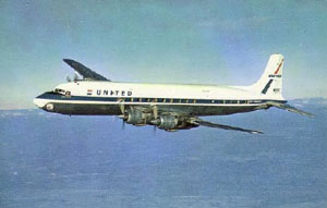
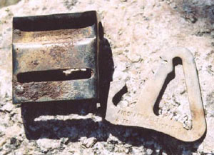
Photo copyright Michael Haywood - used with permission
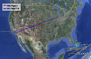
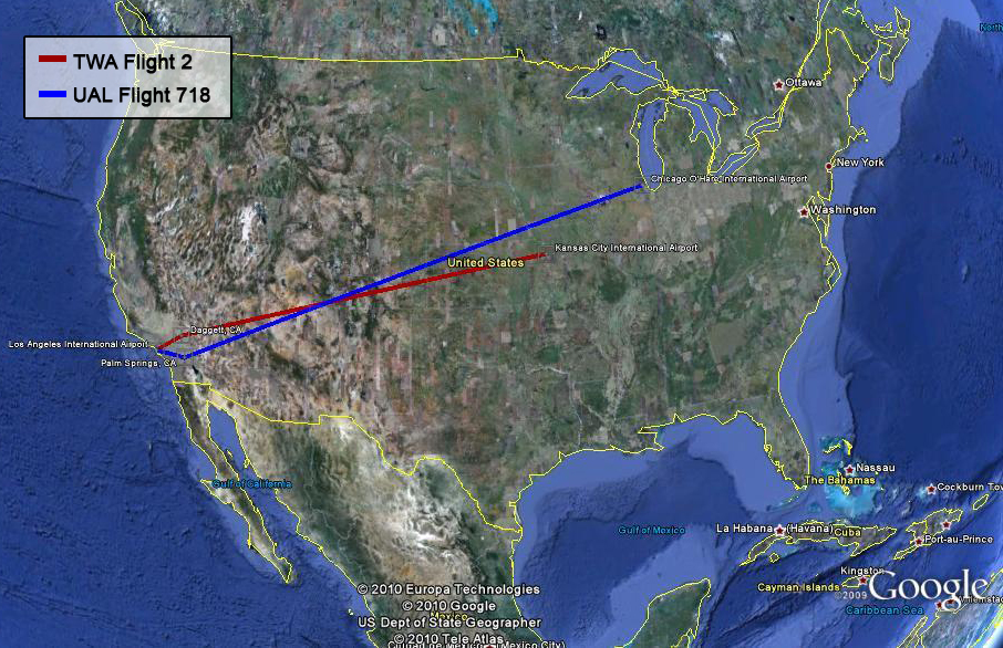
The airliners had both taken off from Los Angeles International Airport that morning only three minutes apart. The TWA flight to Kansas City departed first and initially routed north, while the United flight to Chicago initially routed south. The flight paths were planned to cross near the Grand Canyon, at the Painted Desert line of position as the Kansas City flight routed back south and the Chicago flight routed back north. Although the flight plans called for the flight paths to cross, the planned altitudes differed by 2,000 feet. It was also highly unlikely that the airplanes themselves would actually be at the intersection of the flight paths at the same time. However, the flights both ended up at an altitude of 21,000 feet and collided over the Grand Canyon.
This great loss spurred public debate on the need to mitigate the risk of midair collisions in an age of unprecedented aviation growth. The accident was a major factor leading to the creation of the Federal Aviation Agency in 1958, and to major changes in the control of air traffic.
History of Flights
On June 30, 1956, a TWA Lockheed Super Constellation collided with a United Air Lines Douglas DC-7 over the Grand Canyon. Both aircraft fell into the canyon. There were no survivors among the 128 persons aboard the flights. The collision occurred while both of the regularly scheduled passenger service flights were flying under Visual Flight Rules (VFR).
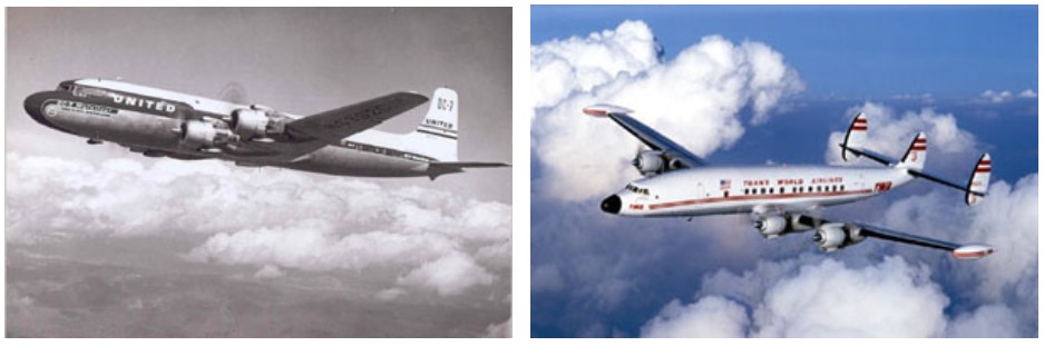
Photo copyright Michael McComb - used with permission
Flight Plans
TWA Flight 2, a regularly scheduled passenger service, was on an instrument flight rules (IFR) flight plan from Los Angeles, California to Kansas City, Missouri. The Lockheed Super Constellation was scheduled to depart Los Angeles at 8:30 a.m. and to fly an established controlled airway from Los Angeles through Daggett, California, and then fly to a series of direct points off controlled airways to Kansas City, Missouri. The TWA flight had a crew of six with 64 passengers. The flight plan proposed a cruising altitude of 19,000 feet and airspeed of 270 knots.
United Airlines Flight 718, a regularly scheduled passenger service, was on an instrument flight rules (IFR) flight plan from Los Angeles, California to Chicago, Illinois. The Douglas DC-7 was scheduled to depart Los Angeles at 8:45 a.m. and to fly an established controlled airway from Los Angeles through Palm Springs, California, and then to fly a series of direct points off controlled airways with a final destination of Chicago, Illinois. The United flight had a crew of five and 53 passengers. The flight plan proposed a cruising altitude of 21,000 feet and airspeed of 288 knots.
The TWA route would bring that flight initially on a more northerly route than the United flight, but the TWA and United flight paths would cross as TWA headed to Kansas City and UAL headed to Chicago. The planned flight paths would intersect before the Painted Desert line of position, over the Grand Canyon.
Chronology of Collision
After a 9:01 take-off from Los Angeles International Airport, TWA 2 was cleared by Los Angeles Air Route Traffic Control Center (ARTCC), or Los Angeles Center, for its en route clearance. The flight was approved for the climb to 19,000 feet in visual flight rules (VFR) conditions for the route to Daggett following an established controlled airway. United Air Lines Flight 718 took off from Los Angeles International Airport at 9:04 a.m., three minutes after TWA 2. United 718 was also given en route clearance by Los Angeles Center. The clearance corresponded to the flight plan as filed; however, the controller specified that the climb to assigned altitude be in VFR conditions. The pilots of both flights chose to fly off-airways after the initial portion of their flights (TWA to Daggett and UAL to Palm Springs) because the controlled airways beyond California were not as direct. Under the regulations at the time, flights were permitted off airways over direct courses provided that a flight plan was filed defining the direct route with several reporting points. There were numerous established company routes.
United 718 made a position report to Aeronautical Radio Inc., which held a contract with United, as it passed over Riverside and later over Palm Springs. When it reported passing over Palm Springs, United 718 indicated that it was still climbing to 21,000, and estimated it would reach Needles at 1000 and the Painted Desert line at 1034. Painted Desert was not a specific point, but a line of position. The Painted Desert line of Position extended northwest from the Winslow omni navigation station. The airplane's radio receiver could detect at what angle the plane was as it passed VOR (Very High Frequency Omni-directional range) radio transmitters. The airplane would be at the Painted Desert line of position when it was at 321 degrees from the Winslow omni radio station. The Civil Aeronautics Board (CAB) accident report has a flight track map that shows the controlled airways that both flights followed out of Los Angeles, and their subsequent direct flight paths and wreckage area.
At 9:21, through TWA company radio communications, TWA 2 reported that it was approaching Daggett, and
requested a change in flight plan altitude assignment from 19,000 to 21,000 feet and, if unable, 1,000 on top to avoid turbulence. The request for "1000 on top" indicated that the flight would be at 1000 feet above the cloud layer/undercast, and allow the airplane to remain in VFR conditions relative to seeing other traffic. The request was forwarded by company radio to air traffic controllers at Los Angeles Center who contacted Salt Lake City control center, which monitored the airspace TWA was about to enter. Los Angeles said "TWA 2 is requesting two one thousand, how does it look? I see he is Daggett direct Trinidad, I see you have United 718 crossing his altitude - in his way at two one thousand." The Salt Lake City controller replied, "Yes, their courses cross and they are right together." The Los Angeles controller then called the TWA radio operator and said "Advisory, TWA 2, unable approve two one thousand." The TWA radio operator replied, "Just a minute. I think he wants a thousand on top, yes a thousand on top until he can get it." After determining from the flight, through the TWA radio operator, that it was then at least 1,000 on top, the Los Angeles Controller issued an amended clearance, "ATC clears TWA 2, maintain at least 1,000 on top. Advise TWA 2 his traffic is United 718, direct Durango, estimating Needles at 0957." The TWA operator gave this clearance to TWA 2, further specifying that the United 718 flight was at 21,000 feet, and it was repeated back to him by the flight.
At approximately 0958 United 718 made a position report to the CAA communications station located at Needles stating that the flight was over Needles at 21,000 feet and estimated reaching the Painted Desert line of position at 1031. At 0959 TWA 2 reported its position to the company radio station in Las Vegas. It had passed Lake Mohave (at the Arizona border) at 0955 was 1,000 feet on top at 21,000 feet and would be reaching the Painted Desert line of position at 1031. This was the last communication with the flight.
Both flights were on uncontrolled direct routes as they left California. The CAA would later explain to the Civil Aeronautics Board that traffic information was not provided outside of controlled airspace, since such information would be of little value as many aircraft unknown to air traffic would be operating in the area. The CAA rules also specified that while an IFR flight is operating in VFR weather conditions, it is the responsibility of the pilot to avoid other aircraft, since VFR flights may be operating in the same area without the knowledge of air traffic control.
At 1031 an unidentified radio transmission was heard by Aeronautical Radio communicators at Salt Lake City and San Francisco. They were not able to understand the message when it was received, but it was later determined by playing back the recorded transmission that the message was from United 718. Context was interpreted as: "Salt Lake, United 718...ah...we're going in."
When neither flight reported passing the Painted Desert line of position and attempts to communicate with the flights were unsuccessful, a missing aircraft alert was issued. That evening, a pilot who operated flights over the Grand Canyon heard about the missing aircraft and had recalled seeing smoke rising out of the canyon earlier in the day. He returned to the area and was able to identify the empennage of the TWA Constellation. He reported that finding, and the next day made another flight, locating the second wreckage approximately one mile from the first. There were no signs of survivors.
Recovery and Investigation
In the days following the accident, the difficult process of investigation and recovery proceeded. The remoteness and topography of the crash sites made the process difficult. A team of Swiss mountaineers was brought in to assist in the recovery operation. After an exhaustive search for eyewitnesses and questioning of potential witnesses, the CAB concluded that there were no reliable eyewitness accounts of the collision.
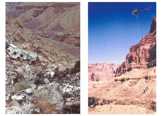
(Right) DC-7 wreckage is removed by Helicopter, Photo copyright Michael McComb - used with permission
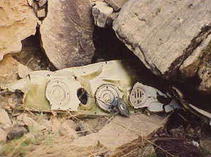
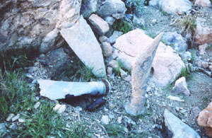
The Civil Aeronautics Board (CAB) embarked upon the challenging task of reconstructing the collision based on the wreckage. Pieces of the left outer wing panel of the DC-7 were found. The lower skin was found to have evidence of the in-flight collision. Some of the collision evidence included red paint from the TWA airplane and fragments of the L-1049 de-icer boot. At the L-1049 wreckage area, a section of the DC-7 lower wing skin was found. This lower wing skin had evidence of contact with the cabin of the L-1049. The L-1049 empennage was found generally intact but at a large distance from the rest of the wreckage, indicating it had separated in-flight after the collision.
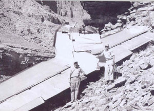
Photo copyright Michael McComb - used with permission
A large piece of fuselage skin from the upper right side of the L-1049 was also found to have evidence of the collision. These pieces of skin had paint marks from the DC-7 and metal smears indicating an object moving up and along the circumferential frames of the L-1049. Finally, there were propeller cuts found in pieces of lower and bottom fuselage of the L-1049. The paint marks at these cuts coincided with the paint scheme on the DC-7 propeller. Due to the difficulty in removing the wreckage from the canyon, much of the accident debris remains in the canyon today.
The CAB concluded that the initial impact occurred with the DC-7 slightly above and moving from right to left relative to the L-1049 and with the L-1049 moving to the right and aft relative to the DC-7. It appears that the first contact was the center fin leading edge of the L-1049, and the left aileron tip of the DC-7. Thereafter, the lower surface of the DC-7 left wing struck the upper aft fuselage of the L-1049 with disintegrating force. This force caused complete destruction of the L-1049 aft fuselage and destroyed the structural integrity of the DC-7 left wing outer panel. The aircraft continued to pass laterally, and the left fin leading edge of the L-1049 and the left wing tip of the DC-7 made contact, tearing off pieces of both. During this time, the DC-7 left propeller cut into the aft baggage compartment of the L-1049. This entire collision sequence occurred in less that one-half second.
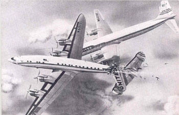
Photo copyright Michael McComb - used with permission
Seen on the right, this artist's depiction of the collision appeared in TIME magazine's April 29,1957 issue. It is a painting done by Milford Hunter, a scientific and technical illustrator with LIFE, and is based on the description of the collision as reconstructed in the CAB accident report.
The CAB also analyzed weather conditions at the time of the collision. In the area of the Grand Canyon where the collision occurred, there were several scattered cloud build-ups. The accident report states, "The build-ups were apparently formed in the lower clouds and protruded through and above them to approximately 25,000 feet." The report further states, "From the evidence available the Board is of the opinion that the weather conditions at 21,000 feet would not have precluded flight in VFR conditions in this accident area but that deviations may have been required to circumvent the buildups while the subject flights traversed the area." Based on United and TWA company procedures and the clearances that were given, the CAB concluded that both flights were operating according to rules prescribed for VFR conditions when the collision occurred. Here is a link to the "Analysis of Horizontal and Vertical Cloud Coverage", which is an attachment to the CAB accident report.
Based on both aircraft's estimates of time to reach the Painted Desert line of position, the aircraft should have been about 17 miles, or 3 ½ minutes flying time father east when the accident occurred. The board was not able to determine the reason for this delay, but did highlight several possibilities. These possibilities include that the airplanes were maneuvering to provide a more scenic view to the passengers, the wind was less favorable than expected, and the cloud buildups in the area may have required course deviations to get around the clouds.
The investigation of the collision and resulting CAB report also evaluated the ability of the pilots of the two aircraft to see and avoid each other. The CAB report discusses factors that inhibit the ability for pilots to see other aircraft in flight. Factors discussed include angular limits of cockpit vision, the distance that an object can be seen, the pilot's physical condition, and training. The CAB report points out that "aircraft converging on constant, unvarying collision courses may provide no relative motion when viewed from the aircraft". The CAB recognized the limitations of the "see and be seen" philosophy, and stated in their report, "This concept has existed as a matter of necessity, with its known limitations, and will continue until there are sufficient technological advances to provide additional assistance to the pilot for collision avoidance." The complete Accident Investigation Report, issued by the Civil Aeronautics Board, is available at the following link: Accident Investigation Report.
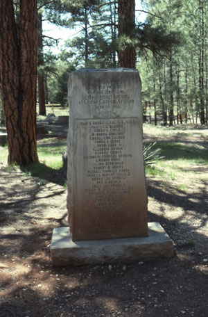
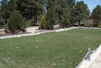
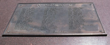
Memorials to the Victims
Two memorial sites were created for the passengers and crew members on the two airplanes. TWA arranged for a burial site at Citizen's Cemetery in Flagstaff, Arizona, where many of the victims from Flight 2 were interred. Many of the victims on United Flight 718 were buried in a site within the Grand Canyon National Park. The memorials are shown in the accompanying photographs.
United Airlines Flight 718
Summary of the CAB findings:
- The TWA flight plan called for a 19,000 ft altitude. TWA requested its company radio to obtain 21,000 feet IFR from ARTCC (Los Angeles Center). This was denied by ARTCC. Request was then made for 1,000 on top. This was approved. As an explanation for the denial of 21,000 feet, TWA 2 was told about UAL 718.
- Air traffic control only had responsibility for separation for IFR flights. When TWA 2 made its amended request for 1,000 on top, it was a VFR clearance under which air traffic control had no responsibility for separation. The assumption was that the planes would be able to see each other.
- The last position report by each flight indicated that both were at 21,000 feet and estimating the Painted Desert line of position at 1031. The Salt Lake City controller had both position reports at approximately 1013, at which time the flights were both in uncontrolled airspace on direct routes. Traffic control services were not provided in the uncontrolled airspace, and according to air traffic control policies and procedures at the time, the Salt Lake controller was not required to issue traffic information. The controller did not take the option of voluntarily issuing traffic information in this case.
- Several cumulus buildups extending above flight level existed; one was nearly over Grand Canyon Village, and others were north and northeast in the area of the collision.
- The collision occurred at approximately 1031 in visual flight rule weather conditions at about 21,000 feet. Under visual flight rule weather conditions, it is the pilot's responsibility to maintain separation from other aircraft.
Full text of Findings from the Civil Aeronautics Board (CAB) report
The Civil Aeronautics Board (CAB) determined that the probable cause of the accident was that:
"...the pilots did not see each other in time to avoid the collision." The board stated that it is not possible to determine why the pilots did not see each other, but the evidence suggests that it resulted from any one or a combination of the following factors:
- Intervening clouds reducing time for visual separation
- Visual limitations due to cockpit visibility and preoccupation with normal cockpit duties,
- Preoccupation with matters unrelated to cockpit duties such as attempting to provide passengers with a more scenic view of the Grand Canyon area,
- Physiological limits to human vision, reducing the time opportunity to see and avoid the other aircraft; or,
- Insufficiency of en route air traffic advisory information due to inadequacy of facilities and lack of personnel in air traffic control.
Full text of Probable Cause from the CAB report
The Civil Aeronautics Board Accident Investigation Report did not contain recommendations.
In the years since this 1956 accident, the Federal Aviation Agency, and subsequently the Administration, has been created. There have been broad sweeping changes to air traffic regulations. In 1956, air traffic regulations were contained in Civil Air Regulations (CAR), Part 60. In 1964, the FAA completed its codification of previous aviation regulatory issuances into the Federal Aviation Regulations. Title 14 of the Code of Federal Regulations (CFR), Subchapter F- Air Traffic and General Operating Rules, contains current air traffic regulations.
Modernization of air traffic control and airways facilities was not keeping pace with the growth of air traffic in the 1950s. The number of mid-air collisions was rising. Military and civilian aircraft were using separate air traffic control systems, and although there had been reports calling for implementation of a common military/civilian air traffic control system, progress was slow. The Civil Aviation Administration's (CAA's) position within the Department of Commerce left it weak and poorly funded.
- There was no requirement for positive air traffic control of aircraft. Radar coverage was only available in the area surrounding large airports. The air traffic control system did not have the ability to segregate VFR traffic from IFR traffic or slow moving flights from faster ones.
- Reliance on "see and avoid" as the sole means of collision avoidance.
There was an assumption that visual flight rules (VFR) "see and be seen" operations could be effective in preventing mid-air collisions. The skies seemed so vast compared with the still relative infrequency of two airplanes flying in close proximity that it seemed that the probability of two large airplanes colliding was small.
The 1950s were a time of growth in the commercial aircraft industry. U.S. air traffic had more than doubled since the end of World War II; however, little had been done to expand the capacity of air traffic control systems, or to increase safeguards against midair collisions. Eighty mid-air collisions occurred in the United States in the period from 1950 through 1955. (Report of Midair Collisions in U.S. Civil Aircraft Operations 1938-1960). However, none of these collisions were between two large air transports. As the number of large transport flights increased, concern was growing about the inability of the ATC system to segregate VFR traffic from instrument flight rules (IFR) traffic, or slow moving flights from faster ones. Many experts recognized the need to institute positive control, requiring instrument flight over certain portions of the airspace irrespective of weather conditions. In February 1956, James Lederer, director of the Flight Safety Foundation said, "No greater evil could befall aviation than a fatal collision between two large air transports."
Photos from "The FAA, A Historical Perspective," copyright Terry Kraus - used with permission
The air traffic control (ATC) system of 1956 was not able to keep up with the growth of the airline industry. A program to modernize ATC was launched in the late 1940s, but its progress was slowed by a number of factors. In 1947 a special committee (SC-31) was established to study and develop recommendations for the safe control of expanding air traffic. In 1948 the SC-31 report was accepted by the Executive Committee of the Radio Technical Commission for Aeronautics. The recommendations included implementation of very-high frequency omni-directional range (VORs) and distance measuring equipment (DME). The report's recommendations were accepted by Congress. In 1950 the CAA began to designate its Victor airways, which were marked for VOR navigation. Pilots would use individual stations as waypoints, flying from one to another.
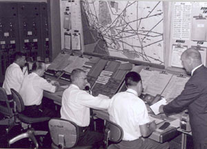
Photo copyright Michael McComb - used with permission
The CAA was under the Department of Commerce, which had a wide variety of responsibilities. Further slowing modernization was a 1950 reorganization of the Department of Commerce which placed the CAA in the hands of an undersecretary, giving it less status. CAA appropriations fell in the early 1950s, and these budget cuts, as well as differences between civilian and military aviation on the direction of ATC, slowed completion of the VOR program.
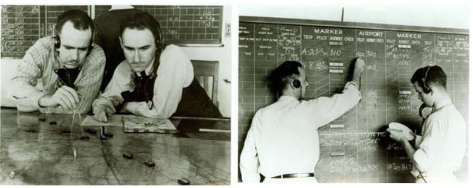
While the navigational modernization was progressing slowly, ATC centers were struggling. Centers had been relying on table maps to depict the airspace and shrimp boats to depict aircraft. With the increase in air traffic, controllers were increasingly relying on visualization. ATC methods transitioned to flight-plan data written on slips of paper, noting each airplanes course, speed, altitude, and estimated time of arrival over checkpoints. Radar began to catch on in the areas near airports in the 1950s, but there were no long-range radars to control en route traffic.
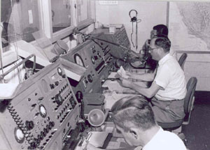
Photo copyright Michael McComb - used with permission
In the mid 1950s, the Air Navigational Development Board (ANDB) established a committee to study the military tactical air navigation system (TACAN) and the civilian VOR/DME to determine which system would be best in the development of a common civilian/military system of air navigation. A series of congressional hearings were held when the committee reported that it was not able to reach a unanimous decision in 1955.
The Harding Report, commissioned in 1955, reported that the need to improve air traffic management had reached critical proportions. President Eisenhower, following the report's recommendations, appointed Edward P. Curtis as his special assistant for aviation facilities planning. His assignment was to develop a plan for meeting the needs disclosed by the Harding Report.
When the American public learned the details of the Grand Canyon collision, there was significant public pressure for changes to civil air regulations. Congressional hearings were opened to address the problems of air traffic control. As a result of the collision, President Eisenhower signed the Airways Modernization Act in August 1957, whose purpose was to develop and modernize the national system of navigation and air traffic control facilities to serve the present and future needs of civil and military aviation. CAA's appropriations grew as the process of modernizing airways facilities and equipment proceeded.
The Grand Canyon collision occurred during the period that Edward P. Curtis was developing a plan in response to the Harding Report. Edward Curtis' report entitled "Aviation Facilities Planning" was released on May 10, 1957. The report recommended the establishment of an independent Federal Aviation Agency. The Federal Aviation Act of 1958 took the administration of airways and air safety from the Commerce Department and put it in the hands of a new Federal Aviation Agency (FAA). The function of accident investigation was left with the CAB. The act called for the FAA to have an administrator appointed by the President and reporting directly to him. General Elwood P. Quesada was appointed by the President as the first FAA Administrator.
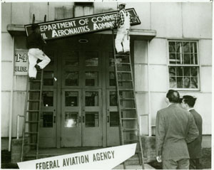
Photo copyright Terry Kraus - used with permission
At the time of the Grand Canyon collision, the debate was continuing in Washington over whether the common civilian/military air navigation system should be the military TACAN or the civilian VOR/DME. Airlines were delaying the purchase of navigational equipment as there was uncertainty regarding what standard would be implemented. At the time of the accident, negotiations on a compromise system were ongoing. Shortly after the collision, in August 1956, the deadlock was broken and the details of a compromise agreed upon. The compromise system, named VORTAC, retained the VOR directional component but replaced civil DME with the distance component of TACAN. Under the agreement, civilian pilots would continue to get directional guidance from VOR, but would receive distance information from TACAN. This compromise was the beginning of a common use navigational system for civil and military users.
The FAA history staff has prepared a compilation of important events in the history of the FAA, which includes the Grand Canyon accident as well as the subsequent events in the development of the FAA and today's air traffic control system. It is available at this link: "FAA Historical Chronology, Civil Aviation and the Federal Government 1926-1996".
Today's U.S. Air Traffic Control System
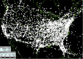
Most air traffic controllers today do their jobs without ever seeing the aircraft they guide. They monitor radar screens to track aircraft. As aircraft fly over radar sites, the data from those radars is communicated digitally via telecommunications lines to controllers hundreds or even thousands of miles away. There are around 7,000 aircraft operating in the air over the United States at any given time.
Controllers in en route facilities guide airplanes flying at high altitudes through large sections of airspace. As aircraft fly across the country, pilots talk to controllers in successive en route centers. There are 21 en route centers that control aircraft flying through U. S. airspace.
At approach control facilities, controllers guide aircraft as they approach or leave airspace surrounding airports to about 40 miles away.
Controllers at most of these facilities handle approach control for many different airports in one facility. For example, Potomac TRACON handles air traffic going into and out of all the airports around Washington D.C., Baltimore, MD., and Richmond, VA. All of the controllers in this facility are experts at one section of the airspace the facility controls, but they work closely together to ensure a smooth transition of all aircraft though the entire region.
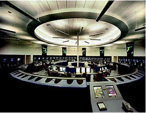
At the Air Traffic Control System Command Center, controllers plan air traffic for the entire country, taking into consideration how weather and other events, such as military maneuvers, will affect air traffic patterns. Command center controllers talk to controllers in other facilities and to airline traffic managers to come up with "master plans."
The public is most familiar with air traffic control towers at airports. Controllers in these facilities guide aircraft as they take off or land and taxi from or to the gate. Their primary function is to separate aircraft on the airport surface. But many airports in the United States don't have towers, so controllers at remote approach control facilities guide aircraft into and out of those airports.
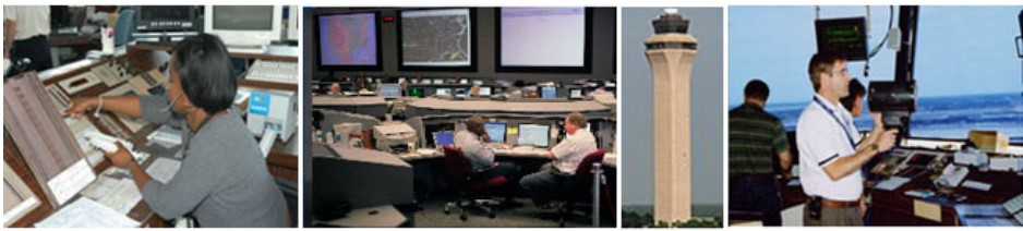
(from left to right)
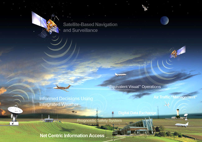
Future U.S. Air Traffic Control System
As the FAA moves through the transition of air traffic control from radar-based to satellite-based, controllers and pilots will have the advantage of increasingly sophisticated technology. While radars require aircraft to fly over their physical locations on the ground, satellite-technology will allow controllers to guide aircraft in more direct routes through the nation's airspace. Essentially, every controller in the United States will be able to see the exact position of every aircraft flying in our airspace, no matter where in the country they work.
As this accident did not involve any airplane failures or anomalies, and was instead an operational accident, no ADs were issued.
Airplane Life Cycle
- Operational
Accident Threat Categories
- Midair / Ground Incursions
Groupings
- N/A
Accident Common Themes
- Flawed Assumptions
Flawed Assumptions
Through the 1950s, air traffic in general, including commercial air traffic, was relatively light, and did not require a high degree of positive control in order to maintain safe traffic separation, or to avoid midair collisions. Radar control was only employed in high volume traffic areas near major airports. Away from airports, especially in the en route portions of commercial flights, it was assumed that flight crews could, and would, adequately maintain traffic separation by adhering to planned altitudes, and by visual acquisition of conflicting traffic in time to avoid collisions. At the time of this accident, air traffic was in the midst of a major increase, and rapidly outpaced the limited capability of the then existing system. As traffic density increased, and flights became more densely spaced, the "see and be seen" philosophy was shown to be incapable of providing consistent collision avoidance. This accident made it apparent that improvements in the air traffic system would be necessary in order to achieve the level of safety that the expected growth in air traffic would require.
| Date | Mid Air Site | Aircraft | Airline | Fatal |
|---|---|---|---|---|
| 04/07/1948 | Northolt | DC-6 | SAL | 39 |
| 05/04/1948 | Berlin, Germany | Viking | BEA | 14 |
| 01/11/1949 | Arlington | DC-4 | EAL | 55 |
| 04/25/1951 | Key West, USA | DC-4 | Cubana | 44 |
| 02/11/1952 | New Jersey, USA | DC-6 | NAL | 26 |
| 06/30/1956 | Grand Canyon, USA | Constellation/DC-7 | TWA/UAL | 128 |
| 08/04/1957 | Moose Jaw, Canada | DC-4M | Trans Canada | 35 |
| 10/22/1958 | Nettuno, Italy | VC-7 | BEA | 31 |
| 10/06/1960 | Orly, France | Caravelle | Air Algeria | 1 |
| 12/16/1960 | New York, USA | DC-8-11/1049 | TWA/UAL | 134 |
| 01/02/1963 | Ankara, Turkey | Viscount 754D | Middle East | 104 |
| 12/05/1965 | Carmel, USA | 707/Constellation | TWA/EAL | 4 |
| 07/19/1967 | Hendersonville, USA | 727-22 | PiedMount | 82 |
| 09/03/1967 | Urbana, USA | DC-9-15 | TWA | 26 |
| 02/08/1968 | New York, USA | DC-7B | EAL | 84 |
| 04/08/1968 | Milwaukee, USA | Convair 580 | North Central | 1 |
| 09/09/1969 | Indianapolis, USA | DC-9-31 | Allegheny Airlines | 84 |
| 09/20/1969 | Hoi An, Vietnam | DC-4 | Air Vietnam | 77 |
| 01/09/1971 | Newark, NJ, USA | 707-323/Cessna 150 | AAL | 2 |
| 06/06/1971 | Duarte, California | DC-9-31 | Hughes Airwest | 50 |
| 07/31/1971 | Morioka, Japan | 727-200 | All Nippon | 163 |
| 12/20/1972 | Chicago, USA | DC-9-31, Convair | North Central/DAL | 9 |
| 05/03/1973 | Nantes, France | DC-9-32 | Iberia | 68 |
| 09/09/1976 | Sochi, USSR | Antonov 24/Yakovlev 40 | Aeroflot | 90 |
| 10/09/1976 | Zagreb, Yugoslavia | Trident/DC9 | British Airlines | 63 |
| 03/27/1977 | Tenerife, Spain | 747/747 | Pan Am/KLM | 335/248 |
| 01/03/1978 | Kano, Nigeria | F28-1000 | Nigeria Airways | 16 |
Technical Related Lessons
A collision avoidance strategy that relies primarily on the "see and be seen" safety philosophy is very much dependent upon human vision and reaction time capabilities. Experience has shown that this strategy alone, especially during cruise flight, involving high closure speeds, concentrated airplane traffic, and various visual conditions, is unreliable. (Threat Category: Midair/Ground Incursion)
- At the time of this accident, the air traffic system was almost totally reliant on a flight crew maintaining their own separation from other aircraft in a "see and be seen" environment. There are inherent limitations to this philosophy, as were demonstrated in this accident. Commercial airliners provide limited visibility above and laterally from their flight path, making visual acquisition of nearby traffic difficult until entering a relatively limited field of view. Further, especially with the speed of modern day commercial airliners, closure speeds and flight path convergence rates are sufficiently high that very little reaction time is available for traffic avoidance once visual acquisition is made. New onboard technology, such as Traffic Collision and Avoidance Systems (TCAS) reduce crew workload in maintaining awareness of the traffic environment around their airplane. In combination with positively controlled airspace above 18,000 feet, and IFR control of nearly all commercial flights, the threat of midair collisions has been significantly reduced.
Common Theme Related Lessons
In order for commercial airplane traffic to safely and efficiently move through highly concentrated airspaces, such as that of the 48 contiguous states of the U.S., an air traffic control system must employ a multi-tier safety strategy which makes use of various technologies, such as radar (or other means to positively establish position), positive radio communication, positive separation, and continuous monitoring from each airplane's origin to destination. (Common Theme: Flawed Assumptions)
- At the time of this accident, radar coverage of airborne traffic was available only in terminal areas (areas near major airports), and once away from airport areas, traffic control was reliant primarily on flight route planning, position reports along planned routes, and estimates of arrival at future waypoints. Limited en route traffic advisories were available, and in many cases, altitude control was at the discretion of the flight crew, and flights could unintentionally fly at the same altitudes as conflicting traffic. Air traffic volumes were increasing rapidly, and outpacing the capabilities of the air traffic system of the era. Numerous studies conducted around the time of this accident concluded that a serious midair collision was essentially inevitable without improvements in the air traffic control system. As a result of this accident, the modern air traffic control system was begun, and the Federal Aviation Agency (which would become the Federal Aviation Administration) took on the task of establishing and maintaining the current system.