
Douglas DC-8 and Lockheed L-1049 Super Constellation
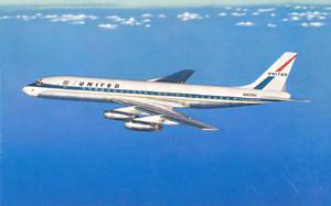
United Airlines Flight 826, N8013U
Trans World Airlines Flight 266, N6709C
Staten Island, New York
December 16, 1960
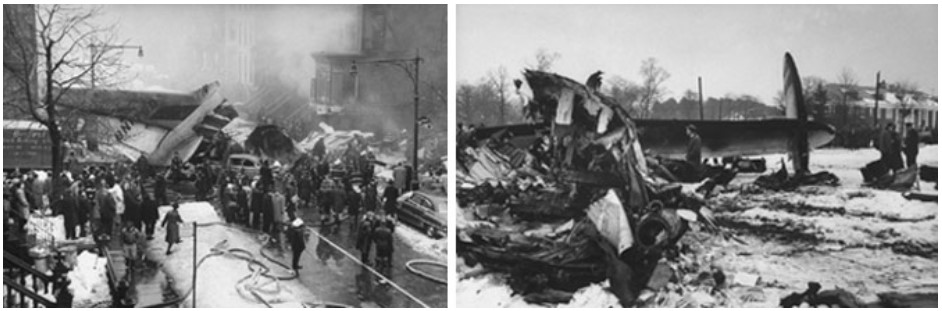
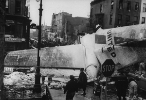
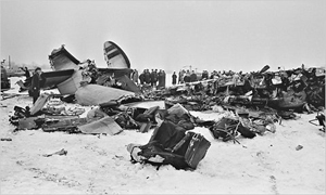
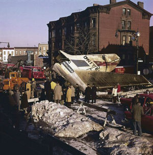
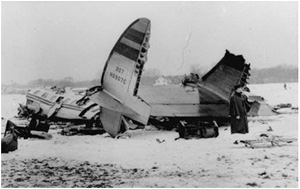
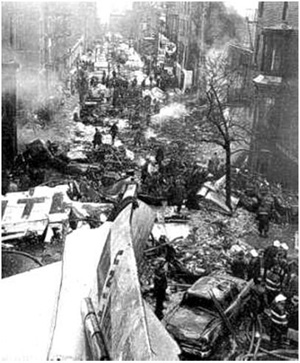
On the morning of December 16, 1960, United Airlines Flight 826, a Douglas DC-8, collided with Trans World Airlines Flight 266, a Lockheed L1049 Super Constellation. The TWA aircraft crashed at Miller Airfield on Staten Island. The United DC-8, however, continued several miles to the northeast and impacted the ground in Brooklyn. The death toll included 128 persons aboard both aircraft and six additional persons on the ground in Brooklyn. This death toll exceeded that of the midair collision over the Grand Canyon four years earlier, making this, at the time, the worst air disaster to date. As a result of the Grand Canyon accident, a broad reaching overhaul of the U.S. air traffic control system was underway. Although these efforts reduced the chance for additional midair collisions, the possibility was not eliminated.
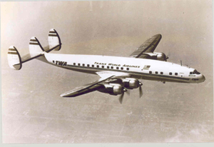
Photo copyright Michael Haywood - used with permission
This accident was a landmark event and caused a re-evaluation of the air traffic modernization effort at the highest levels of government.
Photo copyright Art Brett - used with permission
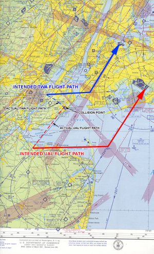
On December 16, 1960, a United Airlines DC-8 collided with a Trans World Airlines Lockheed Constellation over Staten Island in New York City.
The Constellation impacted the ground at Miller Army Airfield on Staten Islanfd, while the DC-8 continued on a northeasterly heading for several miles before impacting the ground in Brooklyn, New York. All 128 persons on board both aircraft died, as well as six persons on the ground in Brooklyn. Instrument meteorological conditions prevailed in the New York area at the time of arrival for both flights. TWA 266 originated in Dayton, Ohio and stopped in Columbus, Ohio, en route to New York City's La Guardia Airport. New York Center cleared the flight to Linden intersection. As the flight approached Linden, control was transferred to La Guardia Approach Control. After crossing Linden intersection, approach control began vectoring the flight to intercept the localizer for runway 04 at La Guardia.
Photo copyright Lawrence Feir - used with permission
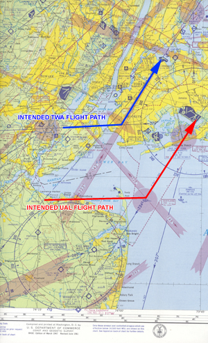
United Flight 826 was en route from Chicago O'Hare Airport to New York's Idlewild Airport (later renamed John F. Kennedy International, or JFK). New York Center was handling the flight as it crossed Allentown VOR and cleared it to Preston intersection with instructions to hold at Preston. As the flight approached Preston, New York Center relinquished control and advised Flight 826 to contact Idlewild Approach Control. The collision occurred when United 826 crossed Preston intersection, having travelled approximately 11 nautical miles northeast of Preston, exceeding their clearance limit.
Separation of aircraft arriving and departing at New York area airports was accomplished by separate routings for each airport. As La Guardia Approach Control was vectoring TWA 266 to intercept the final approach course, the controller observed a fast-moving radar target approaching Flight 266 and advised TWA of this information.
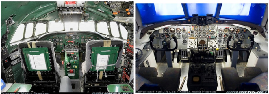
Photo of DC-8 Flight Deck in Training Simulator (right) Photo copyright Yunjin Lee - used with permission
Flight Plans
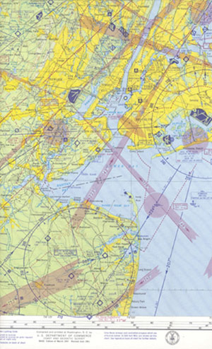
View Larger Image
TWA Flight 266 was a regularly scheduled flight from Dayton, Ohio to New York La Guardia Airport with an intermediate stop at Columbus, Ohio. TWA 266 departed Port Columbus Airport at 0900 on an instrument flight plan with a planned cruise altitude of 7000 feet. Estimated time en route was one hour and 32 minutes with a routing direct to Appleton, Ohio, Victor 12 to Johnstown, Pennsylvania; Victor 106 to Selinsgrove, Pennsylvania; Victor 6 to join Victor 123 to La Guardia Airport. Subsequent clearances changed their altitude to 17,000 feet and then 19,000 feet. At approximately 1005, TWA 266 contacted New York Center over Selinsgrove at 19,000 feet. The flight had five crew members and 39 passengers on board.
United Airlines 826 was a regularly scheduled passenger service from Chicago to New York. The flight departed Chicago O'Hare Airport at 0911 EST on an instrument flight plan to New York Idlewild Airport (currently JFK Airport). The flight plan specified flight level 270 via Victor 55 to join Jet 60 to New York. Estimated time en route was one hour and 29 minutes; true airspeed 478 knots and ground speed 530 knots. Upon reaching Allentown VOR, New York Center cleared the flight to Preston Intersection. Preston Intersection was a feeder fix for aircraft headed to Idlewild Airport from the west. There were seven crew members and 77 passengers on board.
As both flights approached the New York area, they were provided separation by specific routings that provided lateral separation for air traffic arriving at La Guardia and Idlewild. These routes provided a distance of approximately ten nautical miles between the feeder fixes of Linden and Preston Intersections. The flight plan for TWA called for the flight to proceed eastbound on Victor 6 and then intercept Victor 123 and proceed northeast toward La Guardia Airport. Upon reaching Preston intersection, United 826 would follow a normal routing eastbound toward the Scotland radio beacon and then northeast toward Idlewild Airport.
Chronology of Collision
TWA Flight 266
TWA 266 proceeded on course as cleared. At approximately 1005, the flight reported in to New York Center at 19,000 feet. Center then cleared Flight 266 to descend in stages and cross Allentown at 11,000 feet. At 1019, TWA 266 told New York Center that it was passing Allentown at 11,000 feet. Center then advised them that they were in radar contact, cleared the flight to Linden Intersection, and requested they stand-by for descent. At 1021, New York Center cleared Flight 266 to descend and maintain 10,000 feet. At 1023, New York Center advised TWA 266 of the current La Guardia weather:
Measured 500 overcast; one mile visibility in light snow; surface wind from the northwest at 15 knots; altimeter setting 29.66.
View Larger Image
TWA acknowledged this weather and requested the runway in use. Center advised that Instrument Landing System (ILS) approaches were being made to runway 4, and TWA acknowledged. New York Center then cleared Flight 266 to descend and maintain 9,000 feet and to report leaving 10,000 feet; the flight crew acknowledged the instruction. At 1027, TWA 266 informed center that they were past the Solberg VOR, and center acknowledged their call. Soon thereafter, New York Center advised that radar service was terminated and to contact La Guardia Approach Control, which the crew acknowledged.
TWA 266 then contacted La Guardia Approach Control at 1026. Approach control issued a clearance to maintain 9,000 feet and report the "zero one zero Robbinsville." This meant they were to call when crossing the zero one zero degree radial (course from) of the Robbinsville, New Jersey VOR. At 1028, TWA reported passing the zero one zero degree radial, and approach control cleared the flight to 8,000 feet. At 1029, approach control cleared the flight to descend to 6,000 feet and asked for a report when passing through 8,000 feet. TWA 266 called passing 8,000 feet, and La Guardia Approach advised to maintain present heading for a radar vector to the final approach course. The crew acknowledged. At 1030:49, La Guardia Approach Control instructed TWA to reduce to approach speed, and they acknowledged. At 1032:09, approach control told 266 to turn right to a heading of 130 degrees. At 1032:22, LaGuardia Approach Control cleared the flight to continue descent to 5,000 feet. TWA reported leaving 6,000 feet for 5,000 feet, and La Guardia acknowledged.
At 1032:37, La Guardia instructed the flight to turn right to 150 degrees for a new vector. At 1032:47 La Guardia advised, "Traffic at 2:30, six miles northeast-bound." At 1032:51 TWA 266 acknowledged the transmission. At 1033:08 La Guardia Approach Control requested their altitude and confirmed that they were descending through 5,500 feet. At 1033:14 La Guardia issued clearance to descend to 1,500 feet. At 1033:21, La Guardia told TWA 266 to turn left to a 130 degree heading. At 1033:26, La Guardia Approach Control told them, "Roger, that appears to be jet traffic off your right now 3 o'clock at one mile, northeast-bound." Following this transmission at 1033:33, a noise similar to that caused by an open microphone was heard for six seconds. At 1033:43 La Guardia Approach Control called, "Trans World 266, turn further left one zero zero." Subsequently, La Guardia made numerous unsuccessful attempts to establish communication with TWA 266 until 1036:21.
United Airlines Flight 826
After departing O'Hare Airport at 0911, United 826 reached their cruising flight level 270 at 0936, and at 1012 made contact with New York Air Route Traffic Control Center. New York Center advised that radar service was not available and to descend to flight level 250. United 826 reported initiating descent at 1014. At 1015 center informed the flight, "United 826, clearance limit is Preston Intersection via Jet 60 Victor to Allentown direct to Robbinsville, via Victor 123, maintain flight level 250."
At approximately 1021, United 826 called ARINC (Aeronautical Radio, Incorporated), the operator of United's aeronautical communications system, and reported "No. 2 navigation receiver accessory unit inoperative." ARINC acknowledged this transmission and relayed it to United Airlines.
At the same time (approximately 1021), New York Center issued a further clearance to descend to 13,000 feet. United 826 replied, "We'd rather hold upstairs." Center then handed off the flight to another New York Center sector controller. At 1022:41 New York Center called United: "United 826, New York Center, radar contact." United 826 replied, "Roger, we're cleared to 13,000 to maintain 25,000 until we had a conversation with you. If we're going to have a delay we would rather hold upstairs than down." At 1023:30 Flight 826 reported over Allentown at flight level 250, and center acknowledged. At 1024:37 center relayed weather conditions at Idlewild:
1,500 overcast, ½ mile, light rain, fog, altimeter setting 29.65.
Soon after, United stated, "We're starting down." At 1025:09, center amended their ATC clearance as follows:
"826 cleared to proceed on Victor 30 until intercepting Victor 123 and that way to Preston. It'll be a little bit quicker."
NY Daily News
The new routing reduced the distance to Preston intersection by 11 nautical miles. Flight 826 acknowledged the revised clearance at 1025:20. At 1026:49 the flight was cleared to descend to 11,000. The flight acknowledged the clearance at 1026:54 and reported leaving 21,000 feet. At 1028:41 the center controller observed the flight crossing the centerline of Victor 30. United then confirmed that they were established on Victor 30 and requested the distance to Victor 123; the controller advised that the distance was 16 miles. At 1030:07 center cleared United to, "Descend and maintain 5,000 feet." United acknowledged and reported leaving 14,000 feet. The controller then queried, "Look like you will be able to make Preston at 5,000?" United responded that they would try. At 1032:16 center stated, "United 826, if holding is necessary at Preston, southwest one minute pattern right turns ... the only delay will be in descent." Flight 826 responded, "Roger, no delay, we're out of seven." At 1033:01 the flight reported descending through 6,000 feet. At 1033:08 the center called, "826, I'm sorry I broke you up, was that you reporting leaving 6,000 for 5,000?" They replied, "Affirmative." At 1033:20 center instructed: "826, roger, and you received the holding instructions at Preston, radar service is terminated. Contact Idlewild Approach Control." United acknowledged with, "Good day" at 1033:27.
At 1033:28 (timed from the Idlewild approach control tape) United 826 called, "Idlewild Approach Control, United 826, approaching Preston at 5,000." This was the last known transmission from the flight. At the time of this transmission, United 826 believed that they were still approaching Preston intersection, as cleared, when in fact the investigation concluded that the flight had already passed and over-flown Preston by approximately 11 miles.
Approach acknowledged their transmission beginning at 1033:33:
"United 826, this is Idlewild Approach Control, maintain 5,000. Little or no delay at Preston. Idlewild landing runway four right. ILS in use. Idlewild weather 600 scattered, estimated 1,500 overcast; visibility one-half mile, light rain and fog. Altimeter 29.63; over."
The transmission from approach control ended at 1033:54. It was not acknowledged. Subsequent attempts to contact United 826 were unsuccessful. During the accident hearings, it was testified that no Idlewild Approach Control personnel observed United 826 on radar.
The New York Midair Collision Animation is below:
Collision
View Larger Image
LaGuardia radar observations indicated that the two aircraft radar targets merged approximately over Miller Army Air Field, New Drop, Staten Island, New York. After the targets merged, one continued northeast for eight to nine miles. The other target appeared momentarily nearly stationary and then commenced a slow right turn to a southwesterly heading, disappearing from the scope.
The radar target that continued northeast bound was United Flight 826 which remained airborne until crashing 8 ½ miles northeast of Miller Field at the intersection of Sterling Place and Seventh Avenue in Brooklyn, New York. Witnesses stated that the DC-8 was on a northeasterly heading and that one of the right engines was missing.
The radar target that was observed making a slow right turn in the vicinity of Miller Field was TWA Flight 266. The wreckage of the Constellation was distributed around Miller Field. Several pieces of the United DC-8 were interspersed with the Constellation wreckage.
Click to view the full text of the Civil Aeronautics Board Report.
Flight 826 Navigation to Preston Intersection
Investigators believed that the loss of the number 2 VHF (Very High Frequency) navigation receiver and the high speed of United 826 created a difficult navigation situation for the flight crew. Their revised clearance shortened the distance, and consequently the time, to Preston intersection. If both receivers had been operational, the crew would have used both of them and their associated displays: the PDI (pictorial deviation indicator) on the #1 navigation display and the RMI (Radio Magnetic Indicator) on the #2 navigation display to locate Preston intersection. For purposes of illustration, with both navigation radios functioning, the aircraft would be flying on Victor 30, and the flight crew would tune the number one VOR receiver to Colt's Neck and would have the PDI centered on the 114º course to track direct to Colt's Neck. They would then tune the number two VHF receiver to the Robbinsville VOR and watch that RMI for the course of Victor 123 (the 050 º radial) from Robbinsville VOR. As the flight approached Victor 123, the aircraft would turn left to intercept and then track the new 050º radial outbound, thus "turning the corner." To track the new 050º radial, they would place the Robbinsville frequency in their #1 VHF, select the 050º radial in their PDI, and track the airway outbound. They would then tune their #2 VHF to Colts Neck and watch the RMI until the needle moved to the 346º radial from Colts Neck, which would indicate they were passing Preston intersection. The investigation determined that even with both navigation systems working, the flight crew would be quite busy changing frequencies and courses. (Refer to DC-8 Flight Manual Excerpt for pictorial of a DC-8 intercepting and tracking a VOR radial)
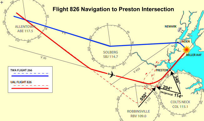
However, with the number two navigation system inoperative, Preston intersection would have been much more difficult to determine. The crew would initially track the V 30 airway (114º course to Colts Neck VOR) on the No. 1 VOR until establishing a heading that would maintain their course. As they approached the "corner," which they determined through time and distance checks, they would retune the number one navigation system to Robbinsville VOR, set in the 050º course, and intercept V 123 outbound from the VOR when the PDI centered. They would then find and hold the heading that was tracking the 050º course, change the frequency on the number one navigation system to Colts Neck VOR, and set in 346º to obtain the 346º degree radial. They would continue to hold the heading that allowed them to track V123 from Robbinsville, and monitor the PDI until the floating pointer centered, thus indicating they were crossing the radial that forms Preston intersection.
As United 826 turned left to intercept V123, it was traveling at over 300 knots indicated airspeed. This would cover the distance of eight nautical miles from the intersection of V30 and V123 to Preston intersection in slightly over one minute. They traversed the additional 11 miles from Preston intersection to the collision site in under two minutes.
United 826 was operating under their own navigation, which meant that they were responsible for flying their assigned course up to their clearance limit of Preston intersection. They were then expected to hold (fly a racetrack pattern) at Preston intersection until Idlewild Approach Control gave them further clearance to proceed. Preston intersection was a feeder fix for Idlewild airport for traffic arriving from the west. From Preston intersection, approach control would route traffic to the Scotland beacon, which was the final approach fix for the ILS to runway 4R at Idlewild airport. Similarly, Linden intersection performed the same function for traffic arriving La Guardia airport from the west. Approach would hold (or stack) traffic at these intersections, pending their clearance for vectors to the final approach course of their destination airport.
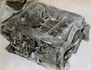
Flight Data Recorder
As a result of a ruling by the Civil Aeronautics Board in 1957 all transport aircraft flying above 25,000 feet were required to have flight data recorders (FDRs). The rule effectively required the new jet transports that began to enter service late in 1958 to be equipped with FDRs. The FDR on the DC-8, manufactured by Waste King, provided detailed information on heading, altitude, and airspeed that assisted in the investigation effort. This was the first accident that was aided by information from an FDR.
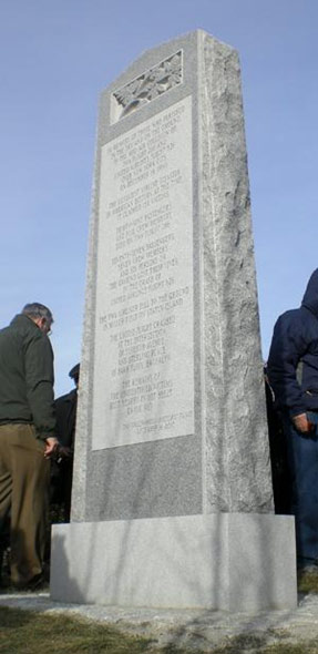
Accident Memorial
Fifty years after the accident, a memorial to the victims of TWA flight 266 and United Airlines flight 826 was dedicated at Green-Wood Cemetery in Brooklyn, New York. The memorial includes a monument containing the names of the passengers on both flights, and the six persons in Brooklyn who died on the ground at the United flight 826 crash site.
Summary of Civil Aeronautics Board Findings:
- "The board believes that the failure to solve the time and distance problem associated with the clearance, in conjunction with the apparent failure of the No 2 VOR accessory unit and resultant pictorial display, caused the passing of Preston Intersection to be unobserved by the flight crew."
- "The crew committed a primary error by apparently failing to record and note the time and distance required to comply with their new clearance. It is logical, in view of the rapidity with which the flight was being maneuvered, to assume that the time and distance from the intersection of Victor 30 and Victor 123 to Preston was not corrected from the original time and distance associated with the Robbinsville/Preston clearance. The original time and distance was probably embedded in the crew's mind and, time-wise, they would have believed that Preston had not been reached."
The CAB determined the probable cause of this accident as follows:
- "The board determines that the probable cause of this accident was that United Flight 826 proceeded beyond its clearance limit and the confines of the airspace allocated to the flight by Air Traffic Control. A contributing factor was the high rate of speed of the United DC-8 as it approached the Preston intersection, coupled with the change of clearance which reduced the enroute distance along VICTOR 123 by approximately 11 miles."
The complete text of the findings begin on page 15 of the accident report. A link to the accident report is available here: (CAB report)
The Civil Aeronautics Board Accident Investigation Report did not contain any recommendations.
The current operating rules (both 14 CFR 91 and 121) had not been codified at the time of this accident. 14 CFR 91 recodified and expanded Part 60 of the Civil Air Regulations. Operational regulations pertinent to the causes of this accident were incorporated into Part 60 and then transferred to 14 CFR 91 following the accident.
Following the midair collision that occurred over the Grand Canyon in 1956, a tremendous effort to improve control of air traffic was under way. The Federal Aviation Administration (FAA) was created in 1958 to coordinate and oversee this modernization effort. During the previous decade (1950-1960) air travel was growing at a rate of 15% per year and midair accidents continued to occur ("Report of Midair Collisions in U.S. Civil Aircraft Operations 1938-1960"). Military and civilian air traffic control and navigation systems that had been evolving independently had to be integrated into a common cohesive system. The cost to procure new equipment and hire and train personnel had to compete with other fiscal priorities.
- Reliance to a high degree on aircraft providing their own navigation in terminal areas with a high concentration of traffic.
- Wide spread use of radar would allow air traffic controllers to oversee and maintain separation of aircraft.
- Aircraft could navigate accurately along assigned routes.
Following the Second World War, air travel began to emerge as a form of mass travel over longer distances. Technology allowed development of faster, more comfortable airliners that were increasingly economical to operate. By the early 1950s, air travel had replaced train travel as the most popular mode for trips over 200 miles.
The government planners responsible for the airways system recognized this upward trend in air travel. New technologies allowed the development of radar that could be used to monitor aircraft. Navigation which had relied on low-frequency radio beacons (that were developed in the 1930s) required improvements to overcome the limitations of the low-frequency beacon system, atmospheric interference, and their limited four-course routings.
On June 12, 1947, Special Committee 31 (SC-31) was established to study and develop recommendations for the safe control of expanding air traffic. The committee issued its report, "Air Traffic Control," on February 17, 1948. It recommended implementation of Very High Frequency (VHF) Omni directional-type ranges (VOR) and Distance Measuring Equipment (DME). The plan called for the ultimate development of reliable, all-weather navigation and landing aids integrated into an ultramodern airways traffic control system.
During the 1950s, different systems began to evolve for different user groups. The U.S. Military developed the Tactical Air Navigation System (TACAN) that provided navigation capability similar to the VOR/DME system recommended by SC-31. The first Victor Airway, utilizing VOR stations, was placed in operation on October 15, 1950. In 1951 the first DME ground stations were placed in operation along the New York to Chicago airway.
In January 1954, the Air Navigation Development Board (ANDB) was reconstituted. Earlier efforts to resolve the TACAN-VOR/DME dispute had produced an impasse in the departments of commerce and defense. One year later the ANDB reported that it was unable to resolve the TACAN VOR/DME controversy. On August 30, 1956, two months after the mid air accident over the Grand Canyon, the Air Coordinating Committee approved a study panel recommendation that VOR and TACAN be combined into VORTAC.
During the 1950s, the military and civilian users were evaluating their requirements for air traffic control. On April 10, 1953 the U.S. Air Force adopted SAGE (Semi-Automatic Ground Environment) as the future air traffic control system. Following their implementation of SAGE, they conducted evaluations for civilian use. On September 11, 1961 the Project Beacon Task Force on Air Traffic Control recommended that only the radar elements of SAGE be adopted for the FAA Air Traffic Control System.
The Civil Aeronautics Board (CAB) noted that during the course of the investigation, the Federal Aviation Administration took the following steps to improve and strengthen the efficiency and effectiveness of its Air Traffic Control System, including the following:
- "A special regulation (SR-445) was issued which requires pilots operating under instrument flight rules to report in-flight malfunctions of navigation or communication equipment."
- "A program has been established for all turbine-powered aircraft to be equipped with distance-measuring equipment (DME) by January 1, 1963. One year later, all aircraft of over 12,500 pounds maximum takeoff weight must be so equipped."
- "Radar handoff service for arriving and departing aircraft in the New York area is being performed to a much greater extent than was practiced before the accident. On a national basis, full-time radar handoff service has increased to a great extent."
- "Controllers have been instructed to issue an advisory to arriving jet aircraft to slow to holding pattern airspeed at least three minutes before reaching holding fix."
- "The Stroudsburg, Pennsylvania VOR name and identification signal (SSB) have been changed to Taunersville (TVE) because of potential confusion with Solberg VOR (SBJ)."
- "The Agency has issued a speed rule which prohibits aircraft from exceeding 250 knots when within 30 nautical miles of a destination airport and below 10,000, except where the safety requirement of tactical jets dictates a higher minimum speed, which then applies to these aircraft."
Project Beacon
On March 8, 1961 President Kennedy requested FAA Administrator Najeeb Halaby, "To conduct a scientific, engineering review of our aviation facilities and related research and development and to prepare a practicable, long-range plan to ensure efficient and safe control of all air traffic within the United States." The FAA's response to this directive was the creation of the Project Beacon task force. Under Project Beacon, eight recognized experts in technology related to air traffic control came together.
On September 11, 1961, the Project Beacon Task Force provided its report to the FAA administrator. The report concluded that substantial improvements were required to meet the future challenge of projected growth in aviation. The report, in effect, recommended a major reorientation in the modernization effort that began in 1957, following the Curtis Report.
A key feature of the Project Beacon Report was the use of an Air Traffic Control Radar Beacon System (ATCRBS) as a primary means of providing controllers with aircraft position information. The FAA had been developing a ground-based 3-D radar to provide position information, including altitude, to controllers. The report also urged expanded use of general purpose computers rather than special use computers then under development.
On November 7, 1961, President Kennedy directed the FAA Administrator, "To begin at once to carry out those recommendations of the report which you believe will move the airways program forward rapidly and efficiently."
Prior to Project Beacon, air traffic controllers relied primarily on radar that operated by reflected energy from an airplane which displayed on radar scopes as a return or "blip." Air traffic controllers identified these returns with specific aircraft when the plane crossed designated navigation points or by instructing the aircraft to perform a series of turns. Air traffic control refers to this use of radar as "primary radar." Installation of a transceiver in an airplane, called a transponder, allows the flight crew to set a code into the transponder that is assigned by the controller. The transponder reports the assigned code to the ground receiving station when it is interrogated by the ground station. This is referred to as "secondary radar."
The first models of transponders were in use on a limited basis at the time of this accident. United 826 was using a transponder while being handled by the New York Center controller between Allentown and Preston intersection. This early type of transponder utilized a two-digit code and was patterned after the military IFF (Identification Friend or Foe) system developed in World War II. Project Beacon's recommended ATCRBS provided for a four-digit code and altitude reporting capability. The early transponder provided for only 64 different codes whereas the ATCRBS system allowed for 4096 different codes. The ATCRBS system greatly simplified tracking of aircraft by air traffic control by permitting continuous display of a unique flight identification and altitude information.
Evolution of the Air Traffic Control System
The Air Traffic Control System has been progressively improved. Continuous improvements have been made in Air Traffic Control computers that will predict and warn controllers of potential collisions.
Reclassification of airspace in the vicinity of the busiest airports segregates IFR (Instrument Flight Rules) from VFR (Visual Flight Rules) traffic.
Requirements for transponders and altitude encoders in congested airspace allow controllers and TCAS (threat collision avoidance system) to identify all air traffic in the area. The position and altitude information reported by the transponder and encoder is integrated in the Air Traffic Control radar, or TCAS, providing flight track, speed, altitude, climb and descent data.
Future U.S. Air Traffic Control System
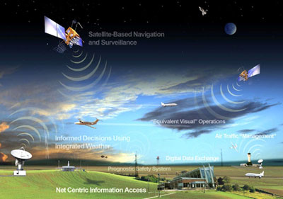
As the FAA moves through the transition of air traffic control from radar-based to satellite-based, controllers and pilots will have the advantage of increasingly sophisticated technology. While radars require aircraft to fly over their physical locations on the ground, satellite technology will allow controllers to guide aircraft in more direct routes through the nation's airspace. Essentially, every controller in the United States will be able to see the exact position of every aircraft flying in our airspace, no matter where in the country they work.
Specific Regulatory Changes:
14 CFR 91.205(e) Powered civil aircraft with standard category U.S. airworthiness certificates: Instrument and equipment requirements.
(e) Flight at and above 24,000 feet MSL (FL 240). If VOR navigation equipment is required under paragraph (d)(2) of this section, no person may operate a U.S.-registered civil aircraft within the 50 states and the District of Columbia at or above FL 240 unless that aircraft is equipped with approved DME or a suitable RNAV system. When the DME or RNAV system required by this paragraph fails at and above FL 240, the pilot in command of the aircraft must notify ATC immediately, and then may continue operations at and above FL 240 to the next airport of intended landing where repairs or replacement of the equipment can be made.
14 CFR 91.117 Aircraft speed.
(a) Unless otherwise authorized by the administrator, no person may operate an aircraft below 10,000 feet MSL at an indicated airspeed of more than 250 knots (288 mph).
(b) Unless otherwise authorized or required by ATC, no person may operate an aircraft at or below 2,500 feet above the surface within four nautical miles of the primary airport of a Class C or Class D airspace area at an indicated airspeed of more than 200 knots (230 mph.). This paragraph (b) does not apply to any operations within a Class B airspace area. Such operations shall comply with paragraph (a) of this section.
(c) No person may operate an aircraft in the airspace underlying a Class B airspace area designated for an airport or in a VFR corridor designated through such a Class B airspace area, at an indicated airspeed of more than 200 knots (230 mph).
(d) If the minimum safe airspeed for any particular operation is greater than the maximum speed prescribed in this section, the aircraft may be operated at that minimum speed.
Malfunction Reports. A special Civil Air Regulation became effective February 17, 1961, making it mandatory for pilots operating under IFR to report to air traffic control any malfunction of navigation or communications equipment. In 1963 it was replaced by the current regulation.
14 CFR 91.187 Operation under IFR in controlled airspace: Malfunction reports.
(a) The pilot in command of each aircraft operated in controlled airspace under IFR shall report as soon as practical to ATC any malfunctions of navigational, approach, or communication equipment occurring in flight.
(b) In each report required by paragraph (a) of this section, the pilot in command shall include the:
- Aircraft identification;
- Equipment affected;
- Degree to which the capability of the pilot to operate under IFR in the ATC system is impaired; and
- Nature and extent of assistance desired from ATC.
Airplane Life Cycle
- Operational
Accident Threat Categories
- Midair / Ground Incursions
Groupings
- N/A
Accident Common Themes
- Human Error
- Flawed Assumptions
Human Error
As United Flight 826 navigated the approach to Idlewild airport, one of the airplane's two navigational receivers failed. The flight was under ATC instructions to navigate to a specific navigational fix (Preston intersection) and hold. In the course of navigating to the intersection, Flight 825 actually overflew the intersection by approximately 11 miles and beyond the airspace in which they were cleared to navigate. This overshoot of the holding fix led to the collision with TWA Flight 266. The CAB concluded that the failure of the navigational receiver complicated navigation to, and identification of, Preston intersection, and led to the possibility for errors to be made by the crew. The CAB concluded that errors in navigation did occur, leading to the flight exceeding its clearance limit and an incursion into other controlled airspace, resulting in the collision with the TWA flight.
Flawed Assumptions
As a result of the Grand Canyon midair collision in 1956, numerous air traffic control procedural advancements were implemented, as well as more widespread use of radar for flight surveillance. However, the system was still highly dependent on navigation by flight crews to place flights in airspace for which they had been cleared to operate, and to follow instructions from ATC to avoid collisions. At the time of the accident, the air traffic system was still highly dependent on position reporting, and airplane altitudes could only be determined, for ATC purposes, via reports from flights. United Flight 826 had been cleared to a specific navigational fix (Preston intersection), and upon arrival at the intersection was to enter a holding pattern at 5,000 feet. It was assumed by both the air traffic controller and the flight crew that the airplane would be properly navigated to the holding point. As a result of a failed navigational receiver, the CAB concluded that navigational errors were made by the crew of Flight 826, leading to the collision with TWA Flight 266. Following the accident, regulatory and operational changes were made (eventually including altitude reporting and more accurate position reporting) that improved flight monitoring capability. Further advances as part of the FAA's NEXGEN system are intended to enhance navigational and position determination for both aircraft and ATC, and are expected to further reduce the possibility of midair collisions.
Following the midair accident over the Grand Canyon, midair accidents continued. During the intervening period prior to the New York midair, the following two accidents were noteworthy.
"An April 21, 1958 accident near Las Vegas, NV involving a United DC-7 and a U.S. Air Force F-100 with the loss of 49 lives in both aircraft. The United DC-7 was on an IFR flight plan cruising in level flight at 21,000 feet under VFR conditions on an airway enroute from Los Angeles to Denver. The F-100 was on an instrument approach to Nellis Air Force Base. The United flight was handled by Civil Aeronautics Administration controllers. The F-100 was under the control of Nellis AFB controllers. At this time civilian and military control systems were not unified. The respective controllers were not aware of the other conflicting aircraft."
"A May 20, 1958 accident near Brunswick, MD involving a Capital Airlines Viscount and an Air National Guard T-33. The Viscount was on an instrument flight plan descending in VFR conditions. The T-33 on a VFR training flight approached from behind and turned across the path of the Viscount resulting in the collision. Air Traffic Control monitored the descent of the Viscount while also observing a faint target from the conflicting T-33 during one sweep of the radar. The controller initiated a call to the Viscount to advise of possible VFR traffic but was unable to contact the Viscount prior to the collision."
Technical Related Lessons
A collision avoidance strategy that relies on maintaining adequate separation between aircraft requires multiple levels of redundancy to minimize the risk of a collision (Threat Category: Midair/Ground Incursion)
- At the time of this accident, separation of airplanes was reliant to a high degree on timing between them, while the flight crews navigated precisely over defined routes. The increased speed of jet airliners also required larger blocks of airspace to provide safe separation from other traffic. Although the advent of radar provided an added layer of protection from the midair collision threat, there remained inherent limitations. Radar displayed aircraft as "blips," a reflected return of the radar beam from an aircraft's structure. In a congested terminal area, a radar scope would display many blips simultaneously. Air traffic controllers had to identify these blips by asking the flight to report when crossing a known navigational aid or by having them make a series of turns. Controllers determined the aircraft's altitude only by asking the flight crew.
- Currently, air traffic controllers monitor flight progress through a network of radars across the U.S. that sends interrogation signals to the airplane's transponder. The transponder sends a signal back to the ground with information as to who it is and how high. The system then uses basic principles of geometry and arithmetic to determine what direction the signal came from and the angle of the signal to determine the plane's distance within one to two miles.
- The FAA is currently engaged in a comprehensive overhaul of the national airspace system, referred to as NextGen, with a goal of full implementation by 2020. During cruise flight, satellite-based navigation, utilizing global positioning system (GPS) and Automatic Dependent Surveillance-Broadcast (ADS-B) will allow planes to fly closer together with no loss of safety, thus increasing airspace capacity. The ADS-B transponder sends signals from the airplane to the ground and uplinks traffic information and weather displays to the plane. This update occurs at once a second versus the current 5-10 seconds return with radar, and controllers can use the information from the airplane's GPS to know its position within a few hundred feet. This will allow them to track airplanes much more precisely and thus allow a greater number of aircraft into the system, since planes can fly more direct routes and are not limited to a "highway" over specified navigation aids. The NextGen system is also intended to significantly reduce the threat of midair collisions.
Flight data recorders (FDR's) and cockpit voice recorders (CVR's) can provide valuable information that is often useful in understanding key aspects of the accident, and can help support improvements to specific airplane models, specific operations, training requirements, and/or changes to the overall aviation safety system. (Threat Category: All - Generally applicable to all threat categories)
- The flight data recorder recovered from the DC-8 provided important information on altitude, heading, and airspeed that aided the investigation effort. It confirmed that the aircraft had slowed about 50 knots to 301 knots in the last minute preceding the collision. The high speed of the DC-8 was a contributing factor in this accident. The high speed effectively reduced the airspace buffer between other flights. As a result of this accident a rule was adopted limiting airspeed to 250 knots below 10,000' within 30 miles of a destination airport. Under current rules an aircraft is limited to no more than 250 knots below 10,000' and would hold at no more than 200 knots below 6000' and 230 knots between 6,000' and 14,000.'
Common Theme Related Lessons
In order for commercial airplane traffic to safely and efficiently move through highly concentrated airspaces, such as that of the 48 contiguous states of the U.S., an air traffic control system must employ a multi-tier safety strategy which makes use of radar, positive radio communication, positive separation, and continuous monitoring from each airplane's origin to destination. (Common Theme: Flawed Assumptions)
- Safely separating air traffic in metropolitan areas where traffic is converging into and out of multiple airports is a complex problem. At the time of this accident, nationwide radar coverage of airborne traffic was available. Air traffic arriving and departing major metropolitan airports were separated laterally by flying over prescribed routes defined by radio navigation and vertically by altimetry. Radar provided real-time monitoring allowing controllers to resolve conflicts and sequence aircraft more accurately. This accident revealed that additional measures, as well as radar, were required to maintain separation between aircraft.