
Perot Field Fort Worth Alliance Airport (AFW)
Perot Field Fort Worth Alliance Airport (AFW) is a medium to large airport located on the northwest edge of the city and 13 miles northwest of Dallas-Fort Worth International Airport. The location makes it a convenient alternative for business travelers and major cargo operations along with general aviation and the military. AFW has a diverse traffic mix and a range of pilot experience levels.
The airspace at AFW is Class D with a ceiling up to but not including 3000’ MSL. AFW airspace underlies DFW Class B airspace (Refer to Sectional Chart).
View a printable Pilot Handbook of the AFW information found on this Web page.
Know Before You Go
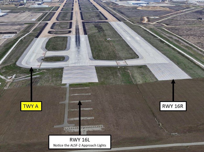
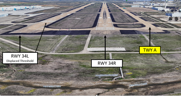
- The runway configuration consists of two parallel RWYs – RWY 16L/34R and RWY 16R/34L.
- TWY A is parallel and runs full length on the east side of the RWYs.
- Closely spaced parallel RWYS and corresponding full length parallel TWYs increase the risk of wrong surface landings and departures.
- A large cargo complex is located abeam the approach end of RWY 34L on the west side.
Below find various AFW-specific information and things to be aware of, as well as general information to inform your preflight planning. This will be reviewed quarterly and updated as needed. This information is to supplement the From the Flight Deck Videos that are produced by the FAA Runway Safety Group. Here you will also find information provided by the local air traffic controllers at the airport where you intend to fly. The information is subject to change. Not for navigation or legal* pre-flight action. Always refer to official pre-flight materials such as, but not limited to, NOTAMs, airport diagrams, VFR charts and airport construction notices for the latest airport-specific details.
AFW Tower: Operates Continuously
Administrative Office: Open 0800L to 1600L – M through F
Business Phone: 817-491-6127
Hot Spots
There are no published Hot Spots at AFW.
Departure
- Verify proper heading prior to starting takeoff roll on all intersection departures.
- Closely spaced parallel RWYS and corresponding full length parallel TWYs increase the risk of wrong surface departures.
Landing
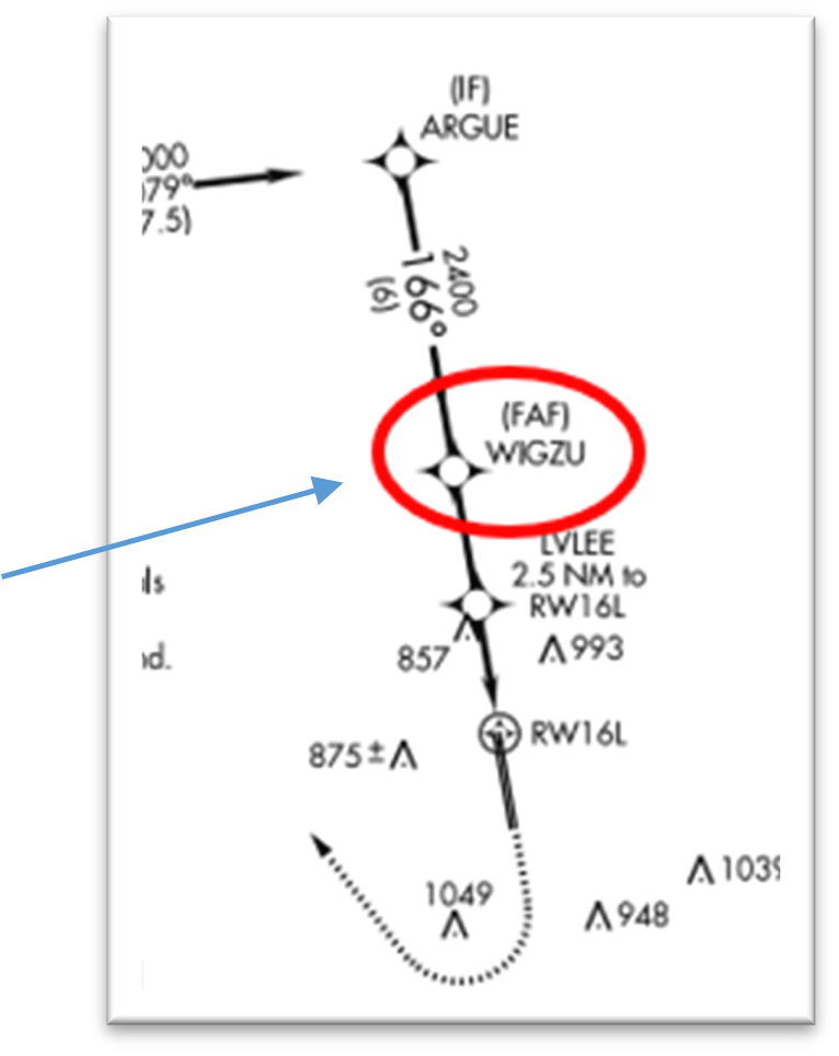
- Approaching from the north on an IFR approach to runway 16L, pilots may encounter traffic inbound or outbound at Northwest Regional Airport-52F. There is no requirement for 52F traffic to talk to ATC so heightened awareness is recommended especially in the vicinity of WIGZU as well as the FAF for both the GPS and ILS approaches.
- After landing on RWY 16L/34R and clearing the RWY to the East, pilots should remain on TWR frequency and not switch to GND until instructed to do so.
- While holding between the two RWYs, pilots are reminded that they need to be completely across the hold short line of the RWY on which they just landed. They must also remain short of the RWY ahead of them.
- There were five (5) separate occasions in the past 5 years when an aircraft was cleared to land on one RWY but landed on the adjacent, parallel RWY.
Wrong Surface Landing Risk
Closely spaced parallel RWYS with a full length parallel TWY increase the risk of wrong surface landings.
Surface Risk – Movement Area
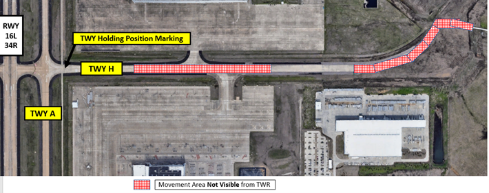
- Portion of TWY H movement area east of TWY A is not visible from the TWR.
- Be aware of Hold Short Line locations.
- TWY A is parallel and runs full length on the east side of the RWYs.
- Due to the large expanse of concrete adjoining the taxiway, some pilots have been unsure of where to enter and exit the ramp in front of the TWR while remaining clear of TWY A.
- A bright green “no-taxi island”, bounded by taxiway edge and movement area hold short markings, has been painted to mitigate this issue.
- Pilots taxiing out from this ramp area should remain clear of the island and not enter the movement area until cleared by GND.
Additional Cautions
- If ever in doubt about your position or instructions, ask the TWR.
- High intensity drone activity can be encountered 400 feet AGL and below, in the vicinity of the Texas Motorsports Speedway, located 3 miles northeast of the airport. This is noted on the ATIS when this is occurring.
General
- AFW is a public use airport owned by the city of Fort Worth, which services a diverse mix of aircraft types: military, cargo, flight schools, helicopters and more.
- Use caution for airport vehicles operating near the runways.
Traffic Patterns
- Traffic patterns are directed by TWR at controlled airports when TWR is in operation.
- When TWR is closed conduct Right Traffic Pattern on RWY 16R
- Generally, the pattern altitude for PROPS is 1700 MSL and JETS 2500 MSL.
Ground
- Due to the limited visibility of TWY H from the control tower, pilots must use extra caution while taxiing westbound on TWY H, approaching TWY A, so that they do not incur on Runway 16L/34R. (See illustration below)
Takeoff/Departure
- Smaller aircraft are often staged to hold short of Runway 16L at TWY’s G and H for departure. Use caution when taxiing out for a full-length departure because these aircraft may block portions of TWY A.
Arrival/Landing
- Use caution for traffic inbound to parallel runway separated by only 600 feet.
- VFR Arrivals should contact the control tower approximately 10 miles out. On initial contact state your intentions/request along with current ATIS on initial call.
Special Traffic (Military / Commercial / Helicopter, etc.)
- Military Aircraft requesting VFR Practice Approaches can generally expect Runway Heading and altitude 025 (two thousand five hundred feet) on departure.
- Use caution for helicopter operations on taxiway P between P1 & P2.
Avoidance Areas
- WIGZU – Frequent heavy jet arrivals in this area - please monitor AFW local control frequency and advise AFW if operating in the vicinity of WIGZU. WIGZU is the FAF on the ILS or LOC RWY 16L approach and is located 5 miles north of AFW. It is also the FAF on the RNAV(GPS) RWY 16L approach.
Additional Information
- RWY 34L threshold displaced 716’.