
Centennial Airport (APA)
Centennial Airport (APA) is located 20 miles south-southwest of Denver International Airport. APA is on the south end of the metro area near the Denver Tech Center which is a major business district. APA is also home to numerous flight schools. The traffic mix of business jets, helicopters and general aviation makes for a challenging airport environment for pilots of all experience levels. Closely spaced parallel RWYs with parallel TWYs along with a complex network of uncontrolled ramp areas await pilots at APA. View a printable Pilot Handbook of the APA information found on this Web page.
Know Before You Go
APA Tower Operates 24 Hours
Administrative Office Open 0700L-1500L M-F
Business Phone 720-873-2770
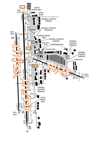
The airport configuration consists of closely spaced parallel RWYs 17L/35R and 17R/35L along with RWY 10/28.
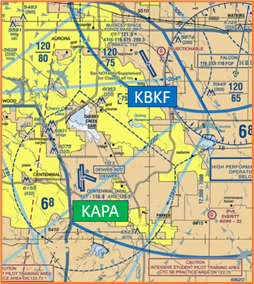
The airspace at APA is Class D and underlies Denver Class B airspace. (Refer to Sectional Chart)
Below find various APA-specific information and things to be aware of, as well as general information to inform your preflight planning. This will be reviewed quarterly and updated as needed. This information is to supplement the From the Flight Deck Videos that are produced by the FAA Runway Safety Group. Here you will also find information provided by the local air traffic controllers at the airport where you intend to fly. The information is subject to change. Not for navigation or legal* pre-flight action. Always refer to official pre-flight materials such as, but not limited to, NOTAMs, airport diagrams, VFR charts and airport construction notices for the latest airport-specific details.
Hot Spots
HS 1: Pilots instructed to taxi to RWY 17L and monitor TWR sometimes enter the RWY without ATC clearance. Expect to hold short.
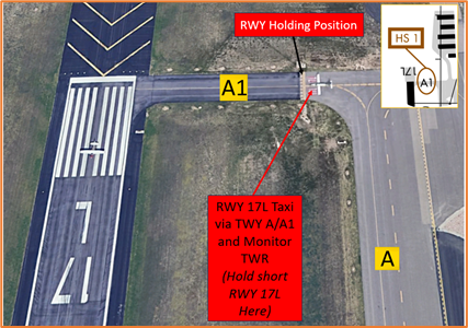
- Actively scanning to locate and identify RWY signs, markings, and lighting and deferring all heads down activities until holding short at the appropriate location will help eliminate these errors.
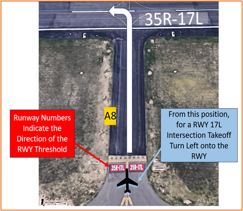
HS 2: TWY A, TWY A8, TWY A9 and TWY C1 congested intersections.
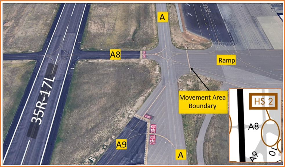
- This large concrete area can be confusing if pilots are not familiar with the airport.
- Pilots on the ramp or pilots crossing/exiting at TWY A8 sometimes enter TWY A without clearance possibly conflicting with other aircraft.
- If you are ever unsure of your position or instructions, ask the TWR.
HS3: RWY 10 hold line on TWY C1 is located 30 ft from edge of ramp.
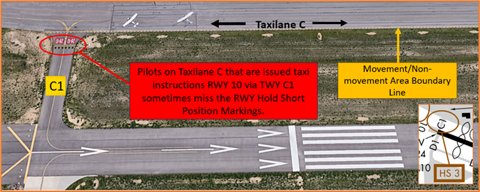
- From the ramp, Taxi-lane C is not a TWY and is not ATC controlled.
- It is located on the ramp and parallels the entire length of RWY 10/28.
- RWY Hold Short Lines are very close to the Movement/Non-Movement Area Markings.
- View the From the Flight Deck - Complex Airfield Geometry#2: Short Taxi Distance from Ramp or Apron to Runway video for additional mitigation strategies.
HS4: Pilots landing RWY 17R and instructed to hold short RWY 17L sometimes enter or cross RWY 17L without ATC clearance. Expect to hold short on TWY B at TWY B8.
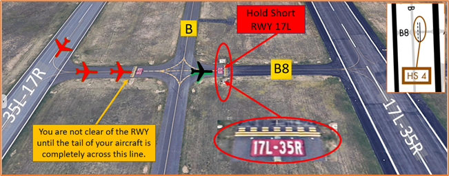
- Aircraft landing RWY 17R/35L are frequently instructed to hold short of RWY 17L/35R at TWY B8.
- The hold line for RWY 17L/35R at TWY B8 is located farther back from the RWY.
- Do not cross this hold line until instructed to cross. This location has frequent RWY incursions. If you are ever unsure of your clearance or position, ask the TWR.
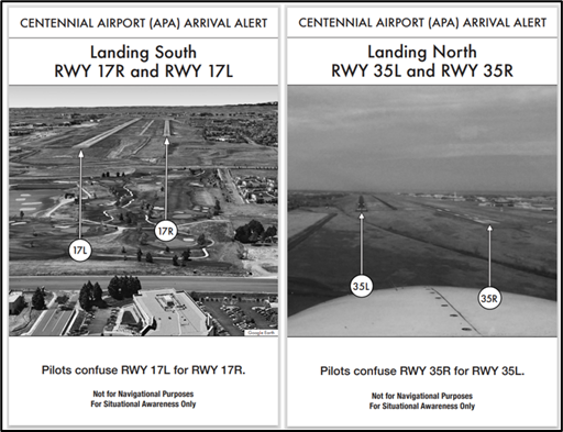
Wrong Runway Landing Risk
- Pilots sometimes confuse RWYs 17L/R and RWYs 35L/R. See Arrival Alert Notices.
- If available, back up all visual approaches with an instrument approach/GPS waypoint to help ensure that you are lined up for the correct surface.
Wrong Surface Risks
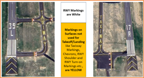
- The risk of landing or taking off on a TWY exists when a TWY parallels a RWY.
- There are several full-length parallel TWYs at KAPA.
- TWY B has the word “TAXIWAY” painted on the surface at the approach ends of RWY 17R/35L as an extra mitigation to a wrong surface landing.
- At KAPA, or any airport, pilots must be aware that an intersection departure presents the risk of taking off in the wrong direction.
- Prior to entering the RWY and again when lining up on the RWY, check your Magnetic Compass and, your Horizontal Situation Indicator (HSI), if installed, to verify that you are pointed in the correct direction.
- View the From the Flight Deck-Wrong Direction Intersection Takeoffs video for more information and mitigation strategies.
The following is local airport specific information that your TWR Controllers want to pass along.
Traffic Patterns
| Left | Right | L/R |
|---|---|---|
| RWY 17L | RWY 17R | RWY 10 |
| RWY 35L | RWY 35R | RWY 28 |
Ground Control
- There is no need for VFR pilots to call Clearance Delivery before departure. Simply contact Ground Control (GC) when ready to taxi.
- VFR pilots state call-sign, type of aircraft, the fact that you are VFR, requested direction of flight and the ATIS code on initial call to GC.
- Do not enter TWYs without contacting GC unless instructed to taxi by TWR.
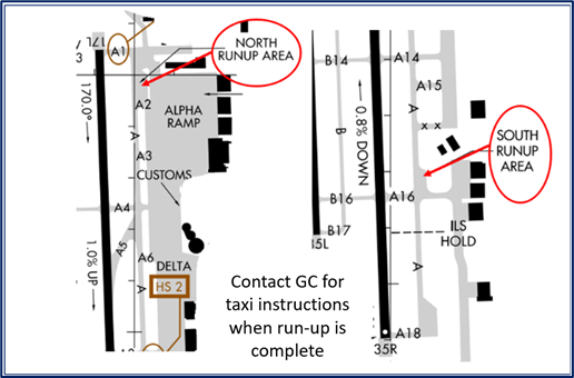
- Hammerheads at the approach ends of RWY 17L/35R are not run-up areas.
- There are two run-up areas located at the north and south portions of TWY A. When run-up is complete, advise ATC and await further taxi instructions.
Runway Crossings
- Read back all hold short instructions with callsign.
Takeoff/Departure
- Pilots should be acutely aware on departure, for both straight out (VFR) and runway heading (IFR), not to drift into the departure corridor of the parallel RWY. The RWYs are 700 feet apart and lower performing aircraft conducting pattern work with high performance aircraft departing behind them can pose risk in the upwind. Be extra vigilant especially on high wind days.
- When instructed to "Monitor Tower," hold short of the RWY and change to TWR frequency. "Monitor" does not mean to call. An instruction to monitor TWR is not a clearance to enter a RWY or to takeoff.
- KAPA utilizes “Line Up and Wait” (LUAW) to instruct a pilot to taxi onto the departure
- RWY and hold position until cleared for takeoff. It is not authorization for takeoff. For mitigation strategies, view the From the Flight Deck-Line Up and Wait video.
Arrival/Landing
- Make sure the RWY you are aligned for is the RWY you were cleared on. RWY 17L/35R is larger and more visible. Sometimes pilots cleared for RWY 17R/35L mistakenly line up for the larger RWY. Make sure the numbers written on the RWY match your clearance.
- Aircraft overshooting final turn can conflict with aircraft on approach to the parallel RWY.
- RWY 17L arrivals can expect low-level helicopter traffic northbound/southbound just east of RWY 17L final and in vicinity of reservoir 3 miles north of the threshold.
Avoidance Areas
- Make sure you remain outside of the KDEN Class B airspace unless you have been cleared into it. The base of the KDEN Class B airspace over KAPA is 8,000.
Special Traffic (Military / Commercial / Helicopter, etc.)
- Low level helicopter traffic proceeding north and south just east of RWY 17L final.
- Buckley Space Force Base (KBKF) is just northeast of KAPA.
Additional Information
- Multiple large power lines approximately 3NM south of RWY 35R/L.
- RWY 10 threshold displaced 400’
- Noise abatement procedures in effect:
- RWY 35R crosswind/base leg north of Lincoln Ave.
- RWY 17L crosswind/base leg south of Arapahoe Rd.
- RWY 17R/35L closed traffic remain south of Arapahoe Rd and east of Interstate 25.
- RWY 10/28 avoid noise sensitive area 1 mi south and east of RWY.