
Livermore Municipal Airport (LVK)
Livermore Municipal Airport (LVK) is a primarily general aviation airport located 25 miles east of San Francisco International Airport (SFO). Numerous flight schools, maintenance facilities, fixed base operators along with a multitude of based airplanes call LVK home. View a printable Pilot Handbook of the LVK information found on this Web page.
Know Before You Go
LVK ATCT Operates: 0700L-2100L
Admin Office Hours: 0600L to 1600L M-F
Business Phone: 925-443-0667
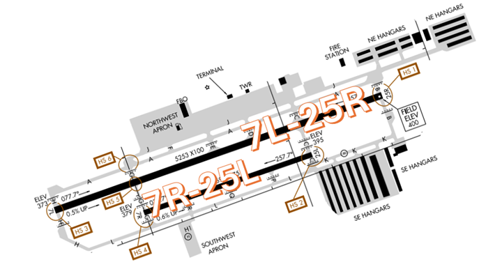
The airport configuration consists of parallel RWY 7L/25R and 7R/25L.
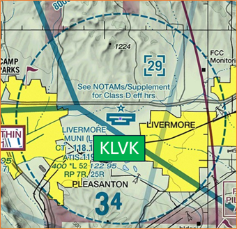
The airspace at LVK is Class D. (Refer to Sectional Chart)
What is a Runway Incursion?
Any occurrence at an aerodrome involving the incorrect presence of an aircraft, vehicle or person on the protected area of a surface designated for the landing and take-off of aircraft.
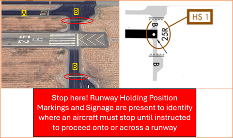
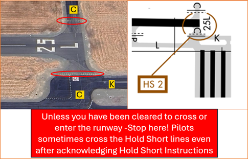
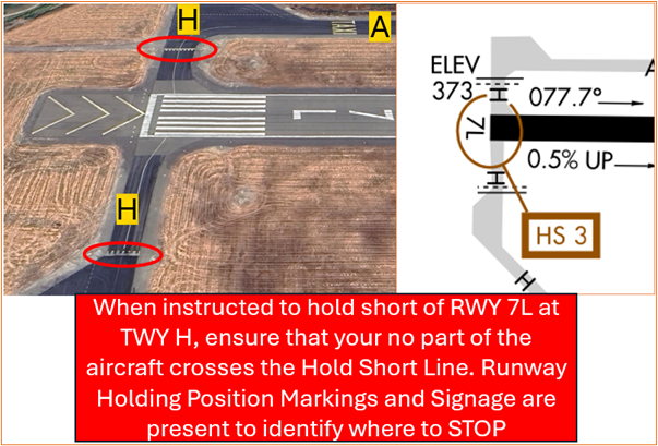
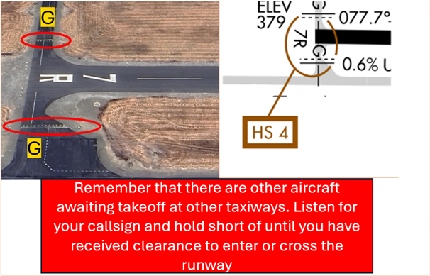
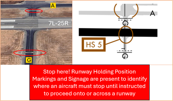
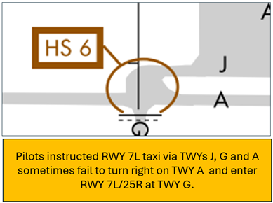
Hot Spots
Hot Spots 1 through 5 reference a shared runway incursion challenge - Aircraft that are taxiing to a runway are not cleared to cross any other runway unless a specific crossing clearance has been issued.
HS 1: Pilots instructed to hold short of RWY 25R at TWY B sometimes fail to comply. Pilots sometimes land on RWY 25R without clearance.
HS 2: Pilots instructed to hold short of RWY 25L at TWY C sometimes fail to comply.
HS 3: Pilots instructed to hold short of RWY 7L at TWY H sometimes fail to comply.
HS 4: Pilots instructed to hold short of RWY 7R at TWY G sometimes fail to comply.
HS 5: Pilots instructed to hold short of RWY 25R at TWY G sometimes fail to comply.
HS 6: Pilots may be confused at the intersections of TWY J, TWY A, and TWY G sometimes fail to comply with taxi instructions.
- For all the above Hot Spot descriptions, pilots should review the taxi clearance before starting to taxi.
- Actively scanning to locate and identify RWY signs, markings, lighting and deferring all heads down activities until holding short at the appropriate location will help eliminate these errors.
- If you are unsure of your position or instructions, ask the controller.
- Pilots are highly encouraged to View the From The Flight Deck-Hold Short video for recommendations and runway incursion mitigation strategies.
Wrong Runway Landing Risk
See Arrival Alert Notices
- Wrong Surface Landing risk exists due to the closely spaced parallel runways.
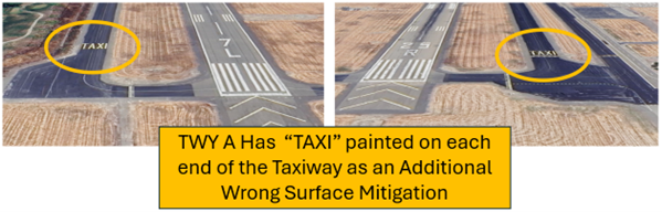
- Whenever a taxiway runs parallel to a runway, the risk of landing on a taxiway increases. Pilots have landed or attempted to land on TWY A from both RWY 7L and RWY 25R.
- If available, back up all visual approaches with an instrument approach/GPS Waypoint to help ensure that you are lined up for the correct surface.
- Remember, RWY markings are white. Markings on surfaces not used for takeoff/landing like TWY markings, chevrons, RWY shoulder and RWY turn-on markings etc., are yellow.
- View the From the Flight Deck-Wrong Surface Landings video for additional mitigation strategies.

General
- None of the runways have an overrun.
- Taxiway Alpha has the word taxi written across it, be careful not to mistake this as runway numbers.
- Be attentive when on frequency so that you don’t step on other’s transmissions or miss instructions issued to you.
Traffic Patterns
- Make all requests for non-standard traffic patterns, turns, etc. through ATC so that they can plan for the maneuver in advance as well as account for noise abatement.
- When TWR is closed conduct Right Patterns on RWYs 7R and 25L.
- When TWR is closed conduct Left Patterns for RWY 7L and 25L.
- Traffic pattern altitude – 1400 MSL.
Ground Control (GC)
- Do not mistake TWY A north of RWY 25R/7L as a runway.
- TWY J is unlit. Pilots should use caution when taxiing in this area.
Takeoff/Departure
- LIVERMORE THREE DEPARTURE (OBSTACLE) – LVK3 is an obstacle departure.
- IFR departures must not turn south prior to ALTAM unless specifically directed to do so by ATC. ALTAM is a flyover fix and turning early significantly increases the risk of conflict with IFR arrivals east of LVK.
- Pilots should review NOTAMS for the Letter to Airmen “LVK: RNAV flying the Conventional LVK3 Departure” LTA-NCT-100 for specific information.
Arrival/Landing
- Be aware that during peak hours, the longer runway may not be available for practice pattern work.
- Due to the closely spaced parallels, jet aircraft often receive TCAS resolution advisories because of aircraft on final, upwind, base, or crosswind for the parallel runway.
- Pilots need to ensure that they do not overshoot the final due to the runways being only 500 feet apart. It is highly probable that there will be traffic for the other parallel runway.
- Northern California TRACON provides IFR Separation for VFR Aircraft Practicing Instrument Approaches. Pilots should review NOTAMS for the Letter to Airmen: LTA-NCT-96 for specific information.
Special Traffic/Helicopters/Additional Information
- Helipad is located on the Southwest Apron.
- Considerable bird activity on and in vicinity of airport.
- Noise sensitive areas 3/4 mile east and 2 miles west of airport.
- Voluntary restraint from night flying 2200L to 0600L.