
Napa County Airport (APC)
Napa County Airport (APC) is a medium-sized, primarily corporate, and general aviation airport located between the cities of Vallejo and Napa in northern California. This location makes it an attractive destination for pilots visiting the famous Napa Valley wine country. Traffic consists of everything from experimental home-built aircraft all the way to large corporate jets. View a printable Pilot Handbook of the APC information found on this Web page.
Know Before You Go
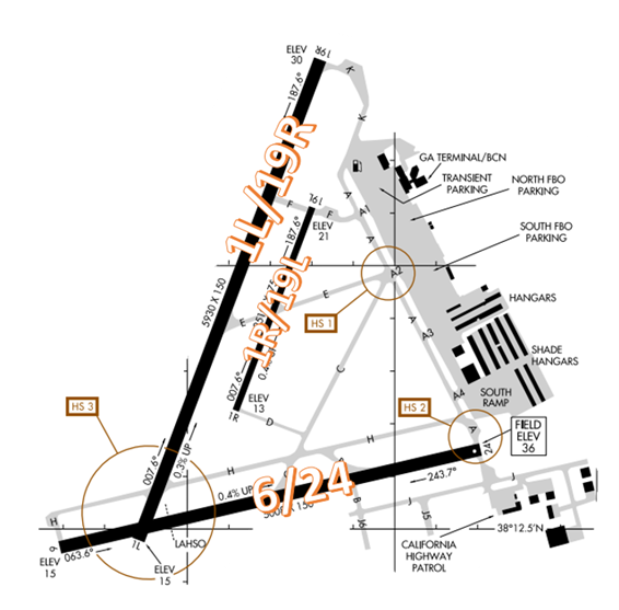
The runway configuration consists of parallel RWY 1L/19R and 1R/19L along with RWY 6/24.
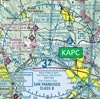
The airspace at KAPC is Class D with a 2,500 ft. MSL ceiling. (Refer to Sectional Chart).
APC ATCT: Operates from 0700L to 2000L Daily
Administrative Office: Open 0800L to 1600L M-F
Business Phone: 707-255-1533
Below find various APC-specific information and things to be aware of, as well as general information to inform your preflight planning. This will be reviewed quarterly and updated as needed. This information is to supplement the From the Flight Deck Videos that are produced by the FAA Runway Safety Group. Here you will also find information provided by the local air traffic controllers at the airport where you intend to fly. The information is subject to change. Not for navigation or legal* pre-flight action. Always refer to official pre-flight materials such as, but not limited to, NOTAMs, airport diagrams, VFR charts and airport construction notices for the latest airport-specific details.
Hot Spots
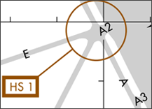
HS 1: Surface Incident Risk - TWY A, TWY A2, TWY C, TWY E, and the ramp - complex geometry due to converging TWYs.
- Aircraft parked at the terminal or any of the transient parking areas must be aware that this intersection is high density and potentially confusing.
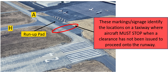
HS 2: Runway Incursion Risk - TWY A at RWY 24 - short distance from ramp to RWY.
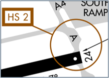
- Pilots exiting the run-up area or the south ramp need to be aware of the RWY 6/24 hold line on TWY A.
- View the From the Flight Deck – Complex Airfield Geometry#2: Short Taxi Distance From Ramp or Apron To Runway for additional information.
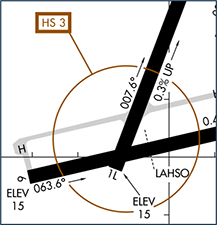
HS 3: Runway Incursion Risk - RWY 1L, RWY 6, and TWY H - aircraft taxiing outbound for departure will encounter runway position hold markings in an unexpected location. Aircraft landing RWY 19R must receive ATC authorization to exit onto RWY 6/24.
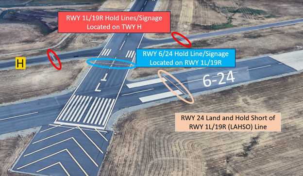
Dependent on the traffic flow, the TWR may use these RWYs to taxi aircraft.
- Pilots who have been cleared to taxi on a RWY have failed to hold short of the intersecting RWY as instructed.
- You must always have clearance to cross/enter any RWY – active or not.
- For all the above Hot Spot descriptions, pilots should review the taxi clearance before starting to taxi.
- Actively scanning to locate and identify RWY signs, markings, lighting and deferring all heads down activities until holding short at the appropriate location will help eliminate these errors.
- If you are unsure of your position or instructions, ask the tower.
- View the From the Flight Deck – Complex Airfield Geometry#7: Hold Short Lines In Unexpected Places for additional information.
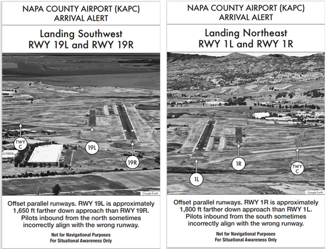
Wrong Surface Landing Risk
See Arrival Alert Notices
- Pilots cleared to land on either of the parallel RWYs have landed or attempted to land on the adjacent parallel RWY.
- If available, back up all visual approaches with an instrument approach or GPS Waypoint to help ensure that you are lined up for the correct surface.
- RWY markings are white. Markings on surfaces not used for takeoff/landing like TWY markings, chevrons, RWY shoulder and RWY turn-on markings etc., are yellow.
- View the From the Flight Deck-Wrong Surface Landings video for additional mitigation strategies.
General
- When calling inbound to the airport be sure to include your intentions (full stop, pattern work, touch and go to the southwest, etc.) for ATC planning purposes.
- Air traffic control regulations require a readback of specific instructions. That includes your call sign with the runway assignment, taxiway and hold short instructions in the same transmission. Any readback that does not include these requirements will have to be repeated, even if you believe you are the only aircraft on frequency.
Traffic Patterns
- If your intentions change while flying in the traffic pattern, let ATC know as soon as practicable, preferably prior to making your turn onto final.
Ground Control
- Calling for taxi with the current ATIS code, direction of flight, and ramp exit point (A1-A4 if applicable) can mitigate unnecessary transmissions on the frequency and help ATC to be more efficient.
Take-off/Departure
- Our primary SID for IFR departures is the Merlot 3 Departure. Pilots do not often see MER3 listed in their FMS. Departing IFR aircraft will find the Merlot 3 in the physical FLIP booklet or other digital database.
Arrival/Landing
- Aircraft should be vigilant when requesting practice approaches to RWY 1L or RWY 6, as they are typically opposite the direction of landing traffic and may conflict with departing traffic.
- The area in the vicinity of the SGD VORTAC is heavily trafficked and is used often by IFR jet traffic inbound and outbound. If flying near this area always remain in communications with ATC for traffic advisories.
- Remain vigilant for heavy bird activity located overhead the waste facility located at the approach end of RWY 24.
- The surrounding terrain can be challenging for first-time pilots inbound to APC.
- Mountains to the N and NE do not allow for straight-in approaches. A modified base leg entry is normal for VFR arrivals.
- IFR aircraft can conduct an approach to either RWY 1L or RWY 6 and circle to RWY 19R.
Special Traffic (Military / Commercial / Helicopter, etc.)
- Be cognizant of the Reach Helicopter ramp to the north of the airport and the California Highway Patrol (CHP) ramp to the south of the airport. Several helicopters arrive and depart from these areas daily.