


Asheville Regional Airport (AVL)
Asheville Regional Airport (AVL) is a multi-use airport, located approximately five miles south of the city of Asheville, North Carolina. It serves the air carrier, air taxi, as well as general and military aviation communities. The taxiway system provides access to all services and hangars located on the east side of the airport. View a printable Pilot Handbook of the AVL information found on this Web page.
Know Before You Go
AVL Tower: Operates 0630L-2300L
Admin Office: Open 0800L to 1600L M-F
Business Phone: 828-684-0421
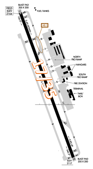
The airport configuration consists of single RWY 17/35 which has a full-length parallel TWY on the east side, and an almost full-length TWY on the west side.
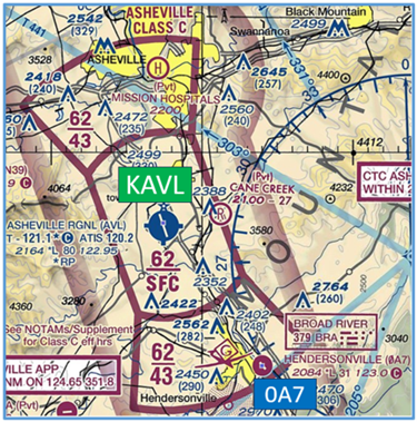
The airspace at AVL is Class C. (Refer to Sectional Chart)
Wrong Surface Landing Risk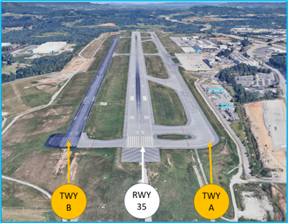
- RWYs with full length parallel TWYs increase the risk of wrong surface landings.
- At AVL, TWY A and TWY B both parallel RWY 17/35 increasing the risk of a wrong surface landing.
- If available, back up all visual approaches with an instrument approach to help ensure that you are lined up for the correct surface.
- RWY Markings are white. Markings on surfaces not used for takeoff/landing like TWY markings, chevrons, RWY shoulder and RWY turn-on markings etc., are yellow.
Additional Cautions
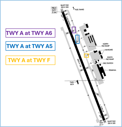
- Due to the occasional overflow parking and positioning of A320 aircraft on the south FBO ramp, visibility to several of the movement areas become obstructed and not visible from the AVL ATCT. We urge all users to use caution when operating in the following depicted areas of non-visibility:
- Pilots should review NOTAMS for Letter to Airmen LTA-AVL-16 Asheville Line of Sight for more information.
- Pilots conducting IFR approaches (ILS or GPS) to RWY 35 at AVL, may encounter Hendersonville Airport (0A7) traffic.
- The floor of the AVL Class C airspace is 4,300’ MSL over 0A7.
- Extra vigilance in this area is highly advised.
General
- There is a multi-year construction project on the east side of the airport impacting non-movement areas near and around the terminal. Airport construction noise may interfere with the controller’s ability to communicate with the stakeholders on the ground or in the air.
Traffic Patterns
- We sequence and make decisions based on expected aircraft/pilot performance. Consistency helps.
- During periods of increased arrivals and departures, it is common for aircraft in the tower pattern to encounter occasional delays.
- Tower pattern direction may vary during operational hours depending on traffic.
Ground Control
- Ask for flight following with clearance/ground if you know you want it rather than waiting until you are talking to departure.
- Informing ground control which taxiway you are using to access TWY A is helpful, along with your aircraft position due to our visibility restrictions from the tower.
Special Traffic (Military / Commercial / Helicopter, etc.)
- Scenic helicopter tours are conducted regularly to and from the North Ramp at AVL. Medevac and military helicopter operations from the ramp are regularly conducted. The ramps are uncontrolled, use caution for rotor wash and helicopter movement.
Takeoff/Departure
- If given a heading other than runway heading, make that turn as soon as you can safely do so.
- AVL utilizes “Line Up and Wait” (LUAW) to instruct a pilot to taxi onto the departure runway and hold position until cleared for takeoff. It is not authorization for takeoff. For mitigation strategies, view the From the Flight Deck-Line Up and Wait video.
- IFR aircraft should be familiar with the AVL7 departure. Some aircraft mistake the published climb rate minimums as the top altitude and stop their climb at 3,600 (Top altitude is 8000).
Arrival/Landing
- On RWY 35, it is typically advantageous to target exiting the RWY at TWY A4 or beyond. TWY A3 may result in taxi delays due to opposite direction traffic taxiing outbound.
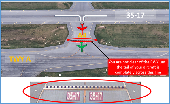
- Aircraft instructed to “Hold Short of Alpha” when exiting the RWY are expected to cross the RWY hold short line before stopping.
Avoidance Areas
- Concentrated downwind IFR arrival traffic five miles west of AVL at 6000 MSL.
- Concentrated training traffic in the vicinity of SUG VOR.
- Frequent helicopter operations in/out of Mission Hospital near downtown Asheville.
- Hendersonville airport near final for RWY 35 approximately nine miles south of AVL.
General Links
Last updated: Monday, August 10, 2026