
Boeing Field/King County International Airport (BFI)
Boeing Field/King County International Airport (BFI) is a multi-use airport located approximately four miles north of Seattle's Sea-Tac airport (SEA). Besides the heavy Boeing presence, the field has a large tour helicopter population as well as General Aviation both based and itinerant. View a printable Pilot Handbook of the BFI information found on this Web page.
Know Before You Go
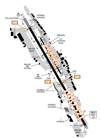
The RWY configuration consists of closely spaced, staggered, parallel RWYs 14L/32R and 14R/32L.
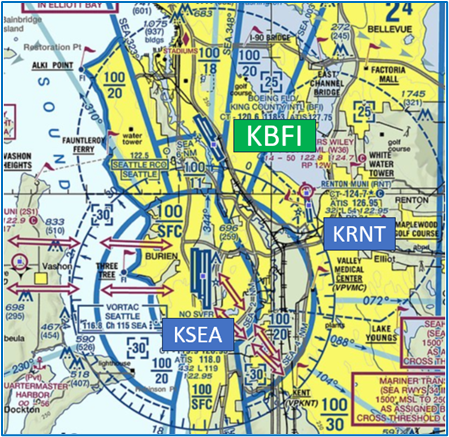
The airspace at BFI is Class D and underlies Seattle Class B airspace. (Refer to Sectional Chart)
Below find various BFI-specific information and things to be aware of, as well as general information to inform your preflight planning. This will be reviewed quarterly and updated as needed. This information is to supplement the From the Flight Deck Videos that are produced by the FAA Runway Safety Group. Here you will also find information provided by the local air traffic controllers at the airport where you intend to fly. The information is subject to change. Not for navigation or legal* pre-flight action. Always refer to official pre-flight materials such as, but not limited to, NOTAMs, airport diagrams, VFR charts and airport construction notices for the latest airport-specific details.
BFI Tower Operates: 24 Hours
Administrative Office: Open 0800L to 1600L M-F
Business Phone: 206-658-6400
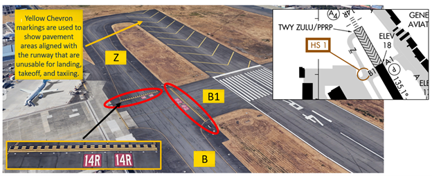
Hot Spots
HS1: TWY Z restricted access area.
- TWY Z appears to be an extension of TWY B however TWY Z can only be used with prior permission from Airport Management.
- When taxiing to RWY 14R do not continue beyond TWY B1 without permission.
- It is always okay to verify with the TWR when you are unsure whether to hold or proceed.
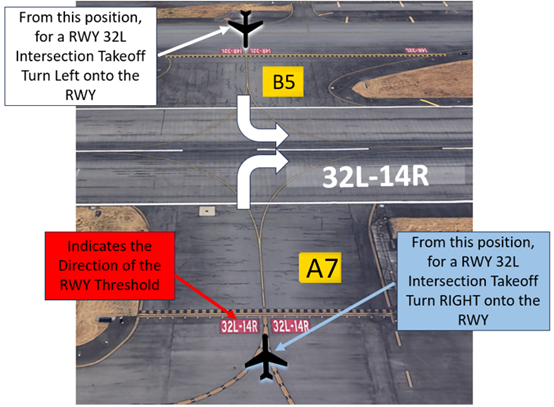
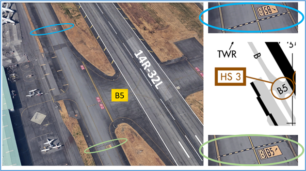
HS2: RWY 14R/32L and TWY A7. Wrong RWY departure risk.
- Pilots must be aware that an intersection departure presents the risk of taking off in the wrong direction.
- The illustration below depicts the intersection of RWY 32L/14R at TWY A7 and B5 (from both sides of the RWY). If approaching the RWY from the opposite direction, the RWY markings will have the numbers reversed.
- Prior to entering the RWY and again when lining up on the RWY, check your Magnetic Compass and, your Horizontal Situation Indicator (HSI), if installed, to verify that you are pointed in the correct direction.
- View the From the Flight Deck-Wrong Direction Intersection Takeoffs video for more information and mitigation strategies.
HS3: Extensive helicopter operations in the vicinity of TWY B5.
- TWY B5 is a Helicopter Landing Area. Pilots taxiing north or south on TWY B must have clearance to cross Hold Short Markings on TWY B.
- If you are ever unsure about your clearance or position, ask the TWR.
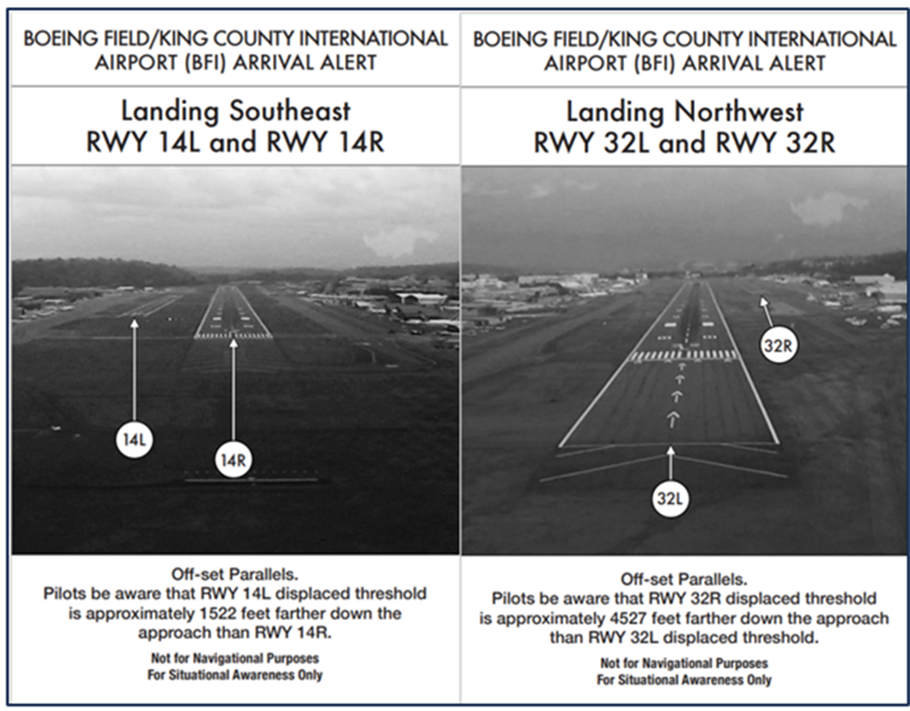
Wrong Surface Landing Risk
See Arrival Alert Notices
- RWY 14L/32R is noticeably narrower and shorter than RWY 14R/32L.
- RWY 14R/32L also has precision approach markings and approach lights.
- When available, back up all visual approaches with an instrument approach.
- Pilots should review NOTAMS for the Letter to Airmen “Closely Spaced Parallel Runways” for facility issued guidance.
Additional Cautions
- West Point and the West Point lighthouse (not depicted on the sectional chart) is an area of highly increased aviation traffic due to sightseers and pilots who loiter in this area at altitudes up to 2000’ AGL or more. Be aware that this area is along/under the BFI 14R localizer.
- Aircraft on approach transition this area at 1600’ AGL and above.
- Increased number of TCAS Resolution Advisories are reported in this area.
- VFR Pilots are strongly encouraged to contact BFI Tower when operating in these areas to receive traffic advisories/instructions to assist in traffic separation.
- If ever in doubt about your position or your instructions, ask the TWR
General
- Tower is normally worked by a controller that is transmitting and receiving on two frequencies at the same time (118.3, for east side traffic, and 120.6, for west side traffic).
- Pilots are encouraged to use good judgment and careful listening to avoid inadvertently taking instructions meant for a different aircraft, and to not make a transmission immediately after the tower has just given an instruction despite hearing silence, as an aircraft is likely reading back the instruction on another frequency.
Traffic Patterns
- Traffic Pattern Altitude RWY 14L/32R 1000 MSL.
- Traffic Pattern Altitude RWY 14R/32L 700 MSL east of the Duwamish River.
Takeoff/Departure
- Read back all runway assignment and hold-short instructions with callsign.
- Search the King County Airport website for current route information.
Arrival/Landing
- Due to the positioning of the BFI Class Delta and the SEA Class Bravo, very little space is available for BFI Tower controllers to provide alternate routes or additional separation when aircraft are arriving/departing the BFI Delta on other than expected VFR routes.
- Seattle Terminal Radar Approach Control (Seattle Approach) will provide IFR separation, to the extent possible, to VFR aircraft executing practice instrument approaches.
- Pilots should review NOTAMS for the Letter to Airmen LTA-S46-29 that covers VFR Practice Approaches at BFI.