
Meadows Field Airport (BFL)
Meadows Field Airport (BFL) is a small sized, public airport located three miles northwest of downtown Bakersfield, CA. Shafter Airport-Minter Field (MIT) is eight miles to the northwest and Bakersfield Municipal Airport (L45) is seven miles south-southeast. KBFL has a diverse mix of traffic including commercial airline operations, general and business aviation, military, air ambulance/law enforcement helicopters and a flight school that is based at the airport. Almost all aircraft services are located on the northeast side of the airport. View a printable Pilot Handbook of the BFL information found on this Web page.
Know Before You Go
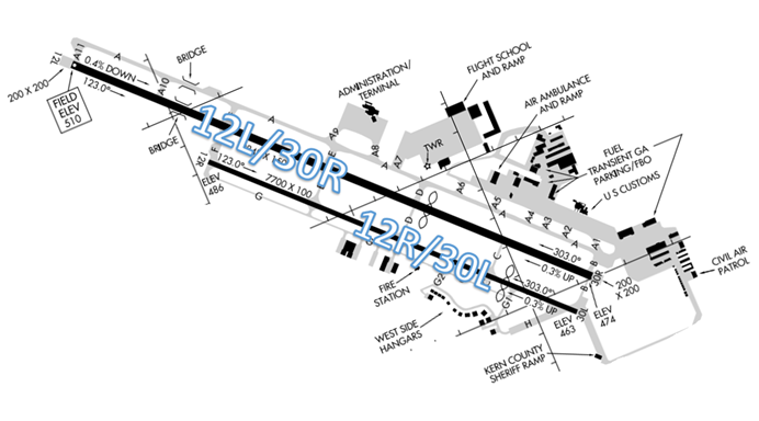
The airport configuration consists of closely spaced parallel RWYs 12L/30R and 12R/30L.
The airspace at BFL is Class D. (Refer to Sectional Chart)
BFL Tower Hours of Operation: 0600L-2300L
Administrative Office: Open 0700L to 1530L M-F
Business Phone: 661-399-3531
Below find various BFL-specific information and things to be aware of, as well as general information to inform your preflight planning. This will be reviewed quarterly and updated as needed. This information is to supplement the From the Flight Deck Videos that are produced by the FAA Runway Safety Group. Here you will also find information provided by the local air traffic controllers at the airport where you intend to fly. The information is subject to change. Not for navigation or legal* pre-flight action. Always refer to official pre-flight materials such as, but not limited to, NOTAMs, airport diagrams, VFR charts and airport construction notices for the latest airport-specific details.
Hot Spots
- There are no Hotspots.
Wrong Surface Landing Risks
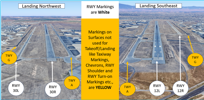
- Parallel RWYs with staggered thresholds present the risk of landing on the wrong RWY.
- Whenever a TWY runs parallel to a RWY, the risk of a TWY landing increases.
- When RWYs are staggered, remember that the first RWY that becomes visible may not be your assigned RWY.
- RWY 12L is approximately one-third longer and wider than RWY 12R and comes into sight before RWY 12R.
- Loading an instrument approach to the assigned RWY will help pilots ensure they are landing on the proper surface.
Wrong Direction Intersection Takeoff Risk
- The length of BFL RWY 12L, at over 10,000’, makes the utilization of intersection departures more efficient and expeditious.
- Pilots must be aware that an intersection departure presents the risk of taking off in the wrong direction.
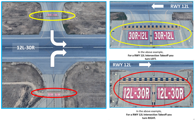
- The illustration below depicts the intersection of RWY 12L at TWY F from both sides of the RWY. If approaching the RWY from the opposite direction, the RWY markings will have the numbers reversed.
- Prior to entering the RWY and again when lining up on the RWY, check your Magnetic Compass and, your Horizontal Situation Indicator (HSI), if installed, to verify that you are pointed in the correct direction.
Surface Movement Area Cautions
- Because multiple TWYs connect to the ramp, congestion may increase during busy operations.
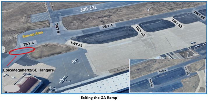
- When taxiing to RWY 30R, GA aircraft exiting the ramp from TWYs A2 through A6 are sequenced on TWY A with aircraft taxiing from the Terminal Ramp.
- Traffic established on TWY A will sometimes be issued a hold short point for traffic exiting the GA ramp.
- Aircraft exiting the ramp at TWY A1 may have to hold short of TWY A for sequencing with traffic on TWY A waiting to turn onto TWY B.
- Aircraft exiting the ramp at TWY A from the SE Hangar area may have to hold short of TWY A on the ramp for sequencing with opposite direction traffic on TWY A.
- Pilots requiring a run-up should advise GC on initial contact.
Pay close attention to instructions from Ground Control and if you are unsure of which aircraft you are following, ask the controller.
- There are several run-up areas on the airfield.
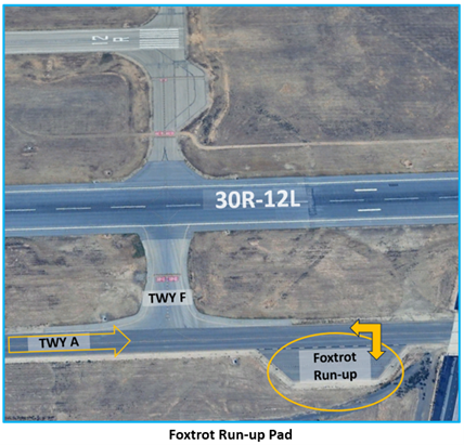
- The only run-up area where special instructions are issued is the Foxtrot Runup Area between TWY F and TWY A10 off TWY A.
- Aircraft taxiing for a RWY 12L intersection departure at TWY F, must pass TWY F to enter the run-up pad. This creates an opposite direction taxi situation with aircraft exiting the run-up pad.
- In this situation, we direct the aircraft in the run-up pad to hold position and advise when run-up is complete. Do not enter TWY A until cleared to do so by GC.
- Note: TWY F is a desirable intersection departure for BFL because low performance aircraft can be crossed to RWY 12R for departure.
Additional Cautions
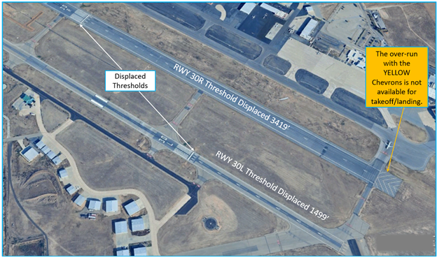
- RWYs 30L/R both have offset and displaced thresholds.
- The portion of RWY behind a displaced threshold is available for takeoffs in either direction or landings from the opposite direction.
Traffic Patterns
- Calm wind runway configuration is RWY 30R/30L. Landing RWY 12L/12R is only used when the tailwind component is in excess of 5 kts on RWY 30R/30L.
- VFR single-engine traffic pattern altitude: 1,000ft AGL (1,500ft MSL)
- VFR multi-engine/turboprop/jet traffic pattern altitude: 1,500ft AGL (2,000ft MSL)
- Pattern-work aircraft can expect RWY 30L/12R for touch-and-goes. High-performance/Large pattern-work aircraft can expect RWY 30R/12L.
- The Kern River is a common landmark used to start a base leg to intercept a 2-mile final for RWY 30R/30L.
- Takeoff/Departure
- Single-engine piston aircraft can expect intersection F departures when RWYs 12L/12R are in use.
- Intersection departures by small aircraft from the same runway that larger aircraft are using may incur wake turbulence delays.
Arrival/Landing
- Visual separation may be required for touch-and-goes following heavier aircraft with same runway wake turbulence considerations.
- The closely spaced parallel RWYs at BFL have centerlines separated by 750 feet.
- Vigilance is required to ensure that you are not only lined up for the correct RWY, but you are also not overshooting final, which could put you dangerously close to aircraft on final to the parallel RWY.
Weather
- BFL’s location in the Southern Central Valley sometimes results in dense fog conditions. Visibilities less than 1/4m are common during the winter. (See Additional Information below for airport impacts)
Additional Information
- Surface Movement Guidance Control System (SMGCS) operations in visibility conditions between 500 - 1,200 ft RVR. SMGCS operations utilize RWY 30R only.
- No aircraft movement on airport surfaces below 500 ft RVR when BFL ATCT is open.
- RWYs 12L/R operations may incur delays and congestion on taxiway A due to the locations of the FBO’s/ramps relative to the departure end of RWY 12’s.
- RWY 12R/30L closed when ATCT closed.