


Air Masses and Fronts: The Movers and Shakers of Weather
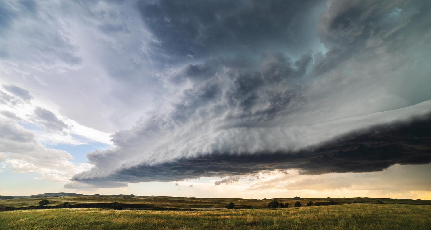
Weather has a tricky tendency to show up unannounced and throw a continent-sized wrench in a pilot’s flight plans. It’s a scenario all too common within the general aviation (GA) community and can have risky consequences for unprepared pilots.
So, what can pilots do to keep weather surprises from ruining their flight? A look at air masses and fronts could offer much-needed insight.
The Big Picture
During pre-flight weather planning, pilots are correct to focus on local conditions and forecasts that affect their route of flight. However, it’s the bigger picture of weather that often gets a casual glance, or worse, is overlooked altogether. Having a panoramic view can provide the extra bit of insight pilots need to make a more informed go/no-go decision or develop a backup plan. Let’s take a comprehensive view into air masses and fronts and how their actions (and interactions) could influence what pilots encounter on their next flight.
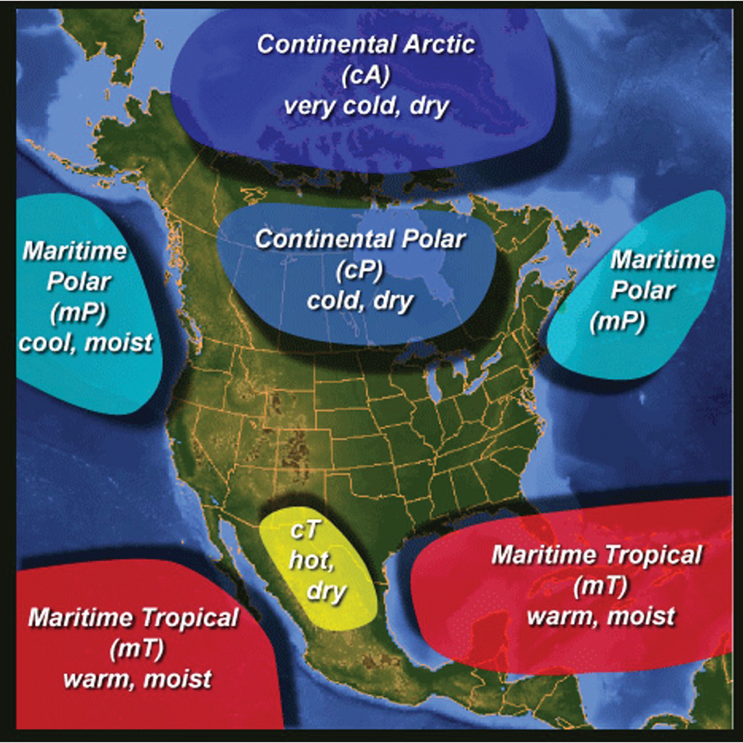
By definition, air masses are large bodies of air that take on the characteristics of their surrounding environment — namely, temperature and humidity — with fairly uniform distribution. They form in certain source regions where air can remain stagnant for days. The weather here in the United States is influenced by air masses formed in four regions (see Figure 1). We have the continental polar (cP) air mass that brings cold, dry air from Canada; the maritime polar (mP) air that brings in moist, cool air from the northwest and northeast oceans; the maritime tropical (mT) regions that bring warm, moist air from the Gulf of America and southern oceans; and finally, the continental tropical (cT) air mass with hot, dry air that forms over Mexico and the southwest United States. There is also a fifth, somewhat infamous region that can affect U.S. weather, known as the continental arctic (cA). The polar vortex we’ve heard so much about the last few years was exactly this, the cA air mass pushing down over parts of the United States, causing a deep freeze that forced its way into the deep south.
On the Front Lines
Like most things in the atmosphere, air masses are constantly on the move once they’re formed. We can attribute that motion to the sun’s energy as it heats the air mostly around the equator. Once heated, the air rises and then flows back towards the poles. Conversely, the colder and denser air at the poles sinks and slides back toward the equator. It’s a hive of climate activity when you also throw in gravity, a planet that spins at more than 1,000 mph, and a complete range of orographic features. All this energy affects air mass movement and ultimately determines whether we need sunglasses or an umbrella to face the day.
As different air masses move around in the atmosphere, they inevitably collide and try to push each other around. It’s a massive and often violent game of give-and-take. When two or more different air masses clash, the area is appropriately called a front.
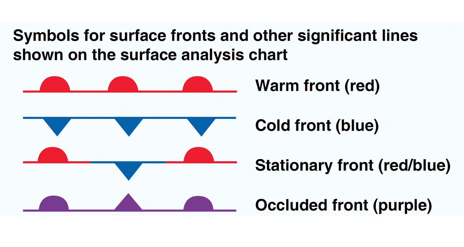
Fronts come in four different varieties: warm, cold, occluded, and stationary (see Figure 2). As even a non-aviator would likely derive from watching the evening news, cold fronts are denoted with blue spikey bands pointed in the direction of movement and form when an advancing cold air mass is replacing a warmer air mass. It might help to imagine the spikey points as giant shovels picking up the warmer air in front of it. The action can sometimes be dramatic, especially when there are large differences in temperature, pressure, and humidity. A good example — and the reason why we see such violent springtime weather across the Great Plains — is when cool, dry air from Canada smacks into the much warmer, humid air rising from the south.
Common by-products of an advancing cold front include pronounced wind shifts and the formation of clouds. The type of cloud depends on the stability of the air mass in the frontal zone, but pilots can generally expect billowy cumulus, or its more stormy relative, cumulonimbus, if sufficient instability and moisture abound. Cold fronts also move rapidly — around 25 to 30 mph in most cases — but some have been clocked at highway speeds of 60 mph!
On The Warm and Fuzzy Side
At the opposite end, warm fronts form when an advancing warm air mass replaces a colder air mass. Maps depict them with red semicircles, which one can envision as bubbles of warm air rising and displacing the cooler air in front of them. Warm fronts are slower than their colder cousins and less pronounced with regard to their overtaking action. There’s usually more of a gentle slope as warmer and less dense air rides up over colder air. Because of this, the humidity in this warmer air condenses as it rises, leading to more widespread areas of thick, soupy weather. In fact, clouds and rain can often precede the surface passage of a warm front by hundreds of miles — something a VFR-only pilot will want to watch out for. A weather map may show a warm front over Missouri, but its IFR-inducing effects could already be several hundred miles east over central Kentucky.
Rounding out the four frontal types are stationary fronts and occluded fronts, which are a “hybrid” of cold and warm fronts. In a stationary front, neither the cold nor the warm side has enough energy to replace the other. They both remain in a sort of a stalled pattern, sometimes for days, with the resulting weather becoming a mixture of the two. While this may seem like a somewhat stable scenario, it’s not uncommon for the edges of a stationary front to kink or bend and become a breeding ground for bad weather. When an upper-level trough (or an area of lower pressure aloft) approaches a stationary front, the front will begin evolving into a frontal system consisting of a warm front and a cold front that will typically start moving eastward. Weather maps depict stationary fronts with alternating red and blue line segments, with the cold/warm symbols pointing in opposite directions.
Occluded fronts form when air masses of different temperatures meet. It’s basically a cold front that catches up and passes a warm front, displacing the warm air mass aloft in the process of pushing into the cold air mass ahead. This air mass “sandwich” is a recipe for having the worst of both worlds, so to speak, as there’s potential for the hazardous features of both cold and warm fronts to be on full display. That means thunderstorms, poor visibility, and shifting winds are all possible. An occluded front is depicted as a purple line with alternating triangles and semi-circles.
Get Up Front with Fronts
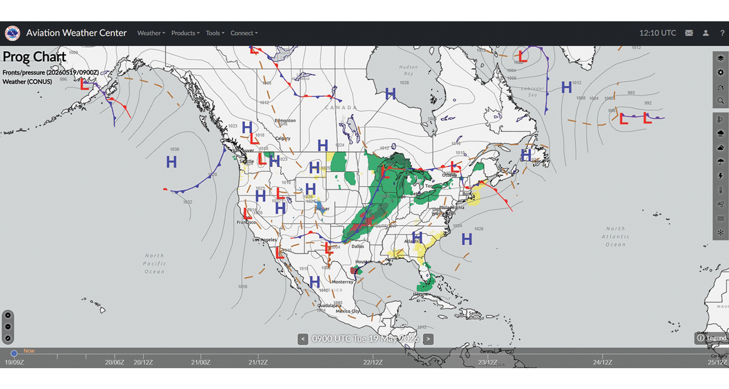
Weather charts provide tons of useful planning data. A surface analysis chart, for example, provides a big-picture view of areas of high and low pressure spanning the lower 48, along with frontal boundaries, temperatures, dew points, wind directions and speeds, local weather, and visual obstructions. Using this chart as part of a preflight can help pilots identify potential trouble spots to focus on or discuss further with a weather briefer. Significant weather and surface prognostic charts (see Figure 3) are two others that can help with painting a good mental picture of the weather.
Another source of information for the big picture is the Area Forecast Discussions (AFD) that each National Weather Service (NWS) office across the nation provides. These text discussions, which the NWS produces two to four times each day, cover the critical weather features that will be causing the expected weather over the next seven days. Not to be mistaken for the Area Forecast Synopsis, these discussions can provide the equivalent of a flight briefing synopsis and more.
Forward, March!
Here are a few strategies pilots can use in the vicinity of a front.
When flying towards a front, if conditions start to deteriorate, land and let the front pass before continuing. Use this chance to reassess the conditions, recalibrate the plan, and perhaps refuel (both pilot and the aircraft). A passing front will likely also cause a shift in wind direction and velocity. The planned approach for the destination may no longer be an option, despite what the initial forecast indicated. Instead, be prepared to land on a much shorter runway or at an alternate airport if the crosswind component is too much to handle. Keep an eye on the altimeter, too. A pressure change when crossing a front is a given.
Passing through the front does not necessarily mean the hazard is over. Even with a cold front, clouds and rain that are usually confined to within a few miles of its boundaries could, in some cases, extend well behind it. And for that matter, there also doesn’t need to be a front nearby to experience adverse weather; that can happen anywhere. Upper-level troughs and lows can generate adverse weather without having an associated surface front.
Pilots should always be prepared and have several backup plans. Pilots should reassess the weather continuously during the flight and use as many in-flight sources as possible: onboard radar, ADS-B In-provided weather, air traffic control (ATC), and, of course, their own two eyes. Allowing for a greater margin of error, especially at night or in low-visibility situations, can be crucial.
It’s important to remember that no two fronts are the same; always expect the unexpected. Forecasts are generally accurate but far from exact. About the only sure thing one can count on with any approaching front is that some type of weather change is imminent.
Be prepared for unexpected weather and avoid any unwanted surprises.
Learn More
- FAA’s Aviation Weather Handbook, Chapter 11, Air Masses, Fronts, and the Wave Cyclone Model
- AOPA Safety Spotlight: Air Masses and Fronts
- GA Pilot’s Guide to Preflight Weather Planning, Weather Self-Briefings, and Weather Decision-Making (PDF)