
Boise Air Terminal/Gowen Field (BOI)
Boise Air Terminal/Gowen Field (BOI) is located southeast of Boise Idaho. It is a joint-use airport serving air carriers, cargo, military as well as general and business aviation. Boise is also home to the National Interagency Fire Center which is responsible for the coordination of wildland firefighting resources throughout the United States. View a printable Pilot Handbook of the BOI information found on this Web page.
Know Before You Go
BOI ATCT Operates: 24 hours
Administrative Office: Open 0800L to 1600L M-F
Business Phone: 208-364-5801
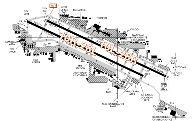
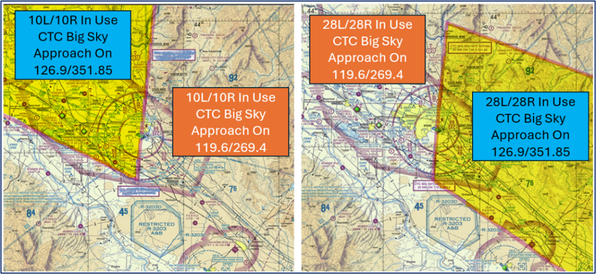
The RWY configuration consists of parallel RWYs 10L/28R and 10R/28L
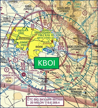
The airspace at BOI is Class C (Refer to Sectional Chart).
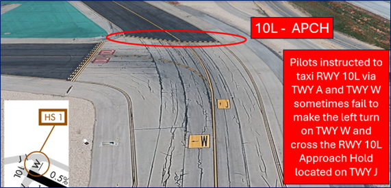
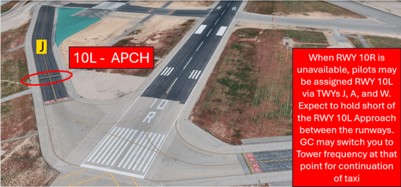
Hot Spots
HS 1: Pilots departing RWY 10L often miss the left turn on TWY W and continue taxi on TWY J. Do not mistake RWY 10L approach sign for RWY 10L entrance.
Surface Movement Area Cautions
- Pilots should review the taxi clearance before starting to taxi.
- Actively scanning to locate and identify RWY signs, markings, lighting and deferring all heads down activities until holding short at the appropriate location will help eliminate these errors.
- If you are unsure of your position or instructions, ask the tower.
- View the From the Flight Deck - Complex Airfield Geometry#7: Hold Short Lines In Unexpected Places for additional information.
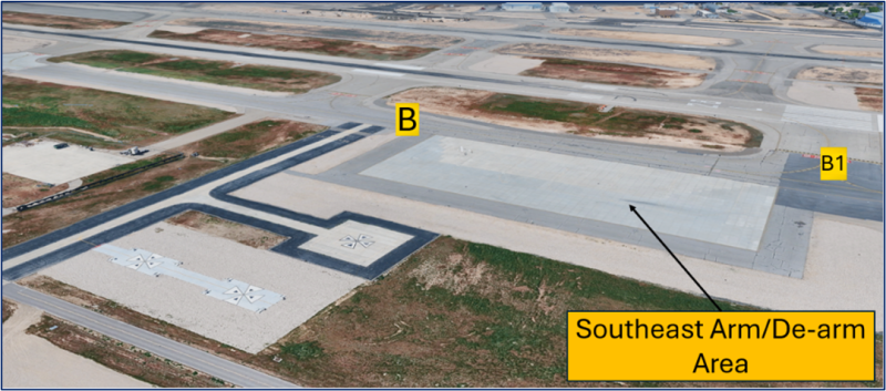
The SE and SW Arm/De-arm pads are sometimes utilized as run-up areas but may be unavailable during military operations.
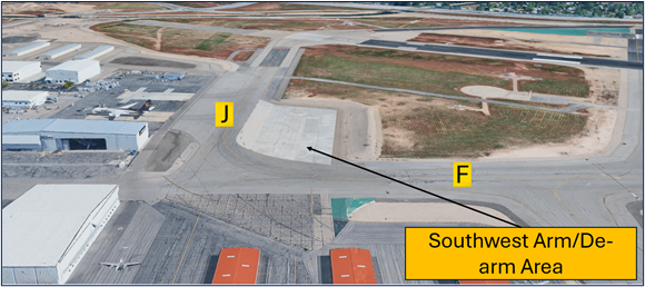
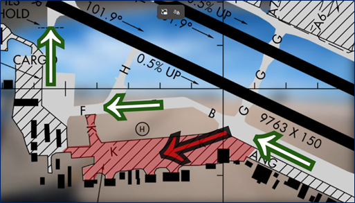
Taxi lane K is a non-movement area and is sometimes mistaken for TWY F.
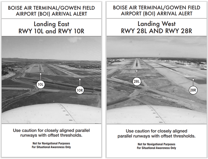
Wrong Surface Landing Risk
See Arrival Alert Notices
- Wrong Surface Landing risk exists due to closely spaced parallel runways with staggered thresholds.
- When BOI is in an east configuration, pilots cleared to land on RWY 10L sometimes align with RWY 10R. Pilots cleared to land on RWY 28L sometimes align with RWY 28R. In both instances, a contributing factor may be that those runways come into view before the assigned runway does.
- If available, back up all visual approaches with an instrument approach/GPS Waypoint to help ensure that you are lined up for the correct surface.
- View the From the Flight Deck - Wrong Surface Landings video for additional mitigation strategies.
Clearance Delivery (CD)
- Clearance Delivery frequency is often combined at Ground Control. This information is broadcast on the ATIS.
- All aircraft need a discrete beacon code when departing BOI.
- Be aware that the departure frequency is dependent upon your direction of flight and the direction of takeoff. This means that you may get a different frequency for the same destination depending on the traffic flow.
- VFR (non-jet) traffic can expect an altitude restriction of “at or below 5000” except when departing to the north from RWY 10L or 10R.
Ground Control (GC)
- Read back all short instructions with the aircraft call sign.
- The SW and SE Arm/De-arm areas may not be available for run-ups during military operations.
Takeoff/Departure
- Readback takeoff clearances including your call sign.
- IFR aircraft and all jets can expect to be assigned runway heading on departure. For IFR aircraft, this is a vector into the Diverse Vector Area (DVA) established at BOI.
- This provides the departure controller with the option to turn aircraft within the DVA as soon as they are clear of any traffic conflicts.
- BOI utilizes “Line Up and Wait” (LUAW) to instruct a pilot to taxi onto the departure RWY and hold position until cleared for takeoff. It is not authorization for takeoff. For mitigation strategies, view the From the Flight Deck - Line Up and Wait video.
Arrival/Landing
- Readback landing clearances including your call sign.
- A paved Military Assault Strip is located one mile south/southeast and oriented like the BOI RWYs.
- Boise is often divided into two sectors. Typically, one sector will work the final approach segment, and the other sector will work everything else.
- Based on the above divisions, if you are arriving/operating within 45° of the final approach course, you should call the final controller (Big Sky Approach) on 126.9. All others contact Big Sky Approach on 119.6.
Special Traffic/Additional Information
- VFR traffic that operates in and out of KEUL/KMAN are advised to use extreme caution when operating above 4500' msl in the area west of BOI. Pilots should review NOTAMS for the Letter to Airmen LTA-BOI-19 for detailed information.
- Extensive Helicopter Operations Surface to 3,500 ‘ within 1 NM East and West & 5 NM South of RWY 10R/28L.
- Moderate Migratory Bird Activity Within 5 NM of the Airport October through March.