
Patrick Leahy Burlington International Airport (BTV)
Patrick Leahy Burlington International Airport (BTV) is a multi-use airport, located just east of the city of Burlington, Vermont. It serves the air carrier, general and corporate aviation communities and is home to the Green Mountain Boys of the Vermont Air National Guard. The traffic mix of light general aviation, air carrier, and tactical fighter aircraft, makes BTV a complex environment for pilots and controllers. View a printable Pilot Handbook of the BTV information found on this Web page.
Know Before You Go
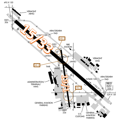
The airport configuration consists of primary RWY 15/33 and RWY 1/19.
BTV Tower: Operates 0530L to 0000L Daily
Administrative Office: Open 0800L to 1600L - M through F
Business Phone: 802-657-4400
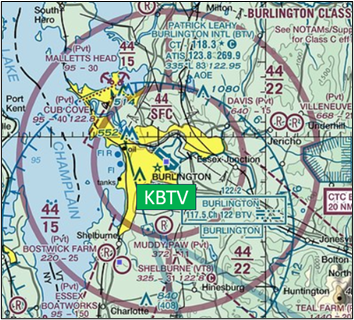
The airspace at BTV is Class C with a ceiling up to and including 4400’ MSL. (Refer to Sectional Chart)
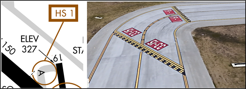
Hot Spots
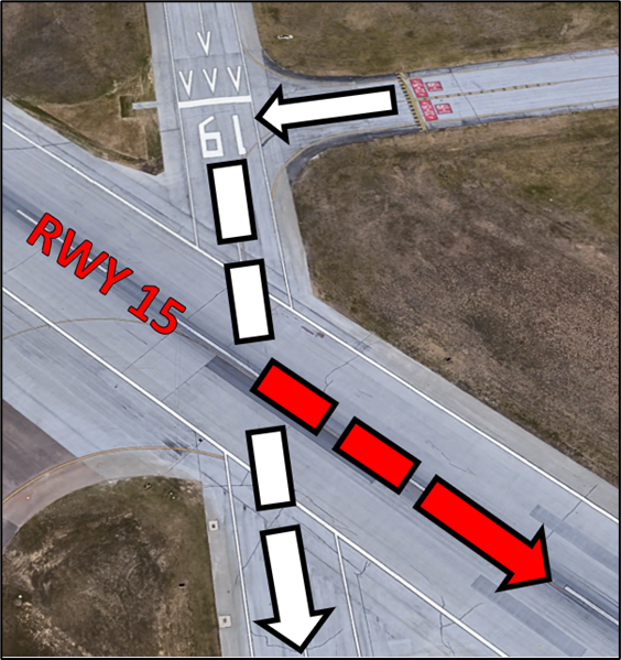
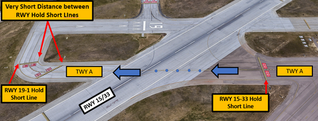
HS 1 RWY Incursion Risk: Limited sight distance while crossing RWY 15/33. Two sets of Hold Short markings in close proximity after crossing RWY 15/33.
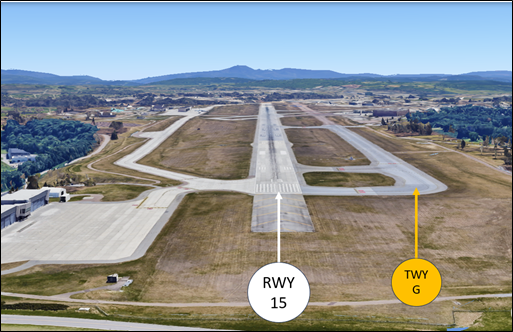
HS 2 Wrong RWY Departure Risk: Wide expanse of pavement confusing pilots instructed to depart RWY 19.
- Pilots may mistake the larger RWY 15 for RWY 19 when turning onto the runway for departure.
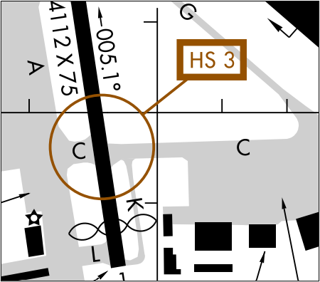
HS 3 Hold Short Risk: Maintain vigilance approaching RWY 1/19 on TWY C from TWY A. Observe elevated RWY guard lights.
- Hotspot 3 has direct access from the ramp to RWY 1/19. The RWY comes up shortly after exiting the ramp, and because of this, some pilots have failed to hold short of the RWY.
Wrong Surface Landing Risk
- Wrong Surface Landing risk exists whenever a full-length TWY parallels the RWY. Positive identification of the landing RWY needs to be a part of every pilot’s landing checklist.
- RWY Markings are WHITE. Markings on Surfaces not used for Takeoff/Landing like Taxiway Markings, Chevrons, RWY Shoulder and RWY Turn-on Markings etc., are YELLOW.
Traffic Patterns
- ATC may delay slower traffic to accommodate faster aircraft for efficient traffic management.
- Pattern work may be limited during times of heavy traffic.
Takeoff/Departure
- TWR will normally assign departing aircraft an initial heading. Fly this assigned heading until receiving further instructions from TWR or Departure Control.
Arrival/Landing
- Advise Approach Control of any special requests as soon as possible, such as pattern work at BTV, sightseeing over downtown Burlington, or practice instrument approaches.
- Heightened pilot awareness of step-down fix altitudes on the ILS/RNAV RWY 33 Approach.
- Land and Hold Short (LAHSO) clearances may be issued to general aviation aircraft. Advise if you are unable to participate.
| LDG RWY | HOLD-SHORT POINT | AVBL LDG DIST |
|---|---|---|
| RWY 1 | 15/33 | 2600 |
| RWY 15 | TWY A | 3600 |
| RWY 33 | 1/19 | 2900 |
Ground Control
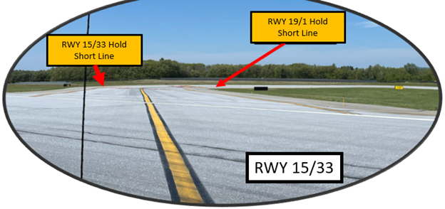
- When taxied to RWY 19, expect to first hold short of RWY 15 at TWY A. When directed to cross RWY 15 at TWY A, do not taxi past the Hold Short Line for RWY 19 without further instructions from TWR. After crossing RWY 15, you will find that the Hold Short Lines for RWY 15 and RWY 19 are very close to each other.
Special Traffic (Military / Commercial / Helicopter, etc.)
- Use caution for jet blast by commercial aircraft near terminal ramp.
- Helicopters should advise Clearance Delivery of requested departure point.
- Be alert for high-speed fighter aircraft within BTV airspace.
Additional Information
- RWY 1, RWY 19, and RWY 33 all have displaced thresholds.
- Use caution for mountainous terrain in the vicinity of BTV.