
Buchanan Field Airport (CCR)
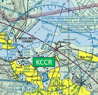
Buchanan Field Airport (CCR) is a medium sized, primarily general and business aviation airport located in the city of Concord, CA, just northeast of the San Francisco – Oakland Bay area. Its location just outside the SFO Class Bravo airspace makes it an attractive alternative to pilots visiting the area, and it is home to no less than three major flight schools. The mix of itinerant, student, and locally based pilots and aircraft, makes CCR a challenging airport for both controllers and pilots. View a printable Pilot Handbook of the CCR information found on this Web page.
Know Before You Go
Buchanan Field Airport (CCR) is a primarily general and business aviation airport located in the city of Concord, CA. Its proximity to the San Francisco Bay area makes CCR an attractive alternative for pilots. CCR is home to no less than three major flight schools making for a challenging mix of air traffic.
CCR ATCT: Operates from 0800L to 2300L Daily
Admin Office: Open 0800L to 1600L M-F
Business Phone: 925-685-5743
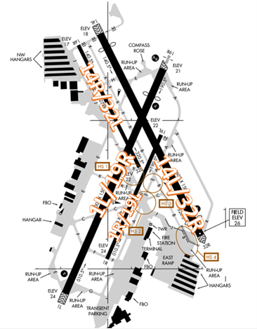
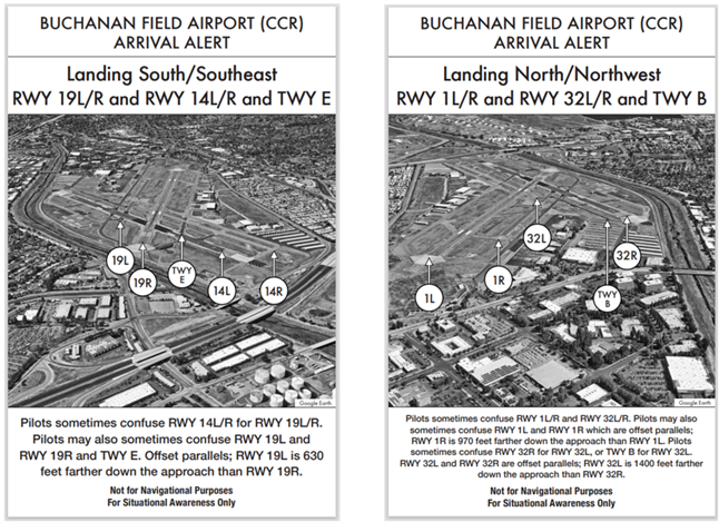
The RWY configuration consists of parallel RWYs 1L/19R and 1R/19L along with RWY 14L/32R and RWY 14R/32L.
Several Hot Spots and other areas of concern are associated with run-up areas. The taxiway system at CCR is complex and close reference to the Airport Diagram is recommended.
Hot Spots
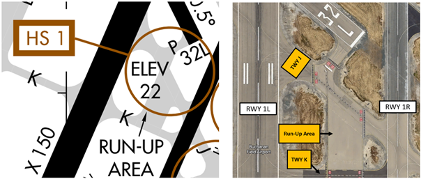
HS 1: Wrong Surface Departure Risk. RWY 32L Run–up area and TWY J. TWY J can be mistaken for RWY 32L.
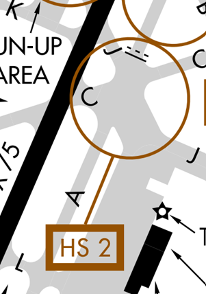
HS 2: Risk of runway incursion and/or surface incident. TWY J, TWY A, TWY C, and TWY K. Expanse pavement and complex geometry due to converging TWYs.
- HS 2 is a complex intersection of multiple taxiways. The intersection of TWYs J, A, C and K can be confusing and can lead to a runway incursion onto RWY 1R/19L.
HS 3: Runway incursion risk. RWY 32L approach hold area on TWY A between TWYs J and B. Holding Position Marking in an unexpected location.
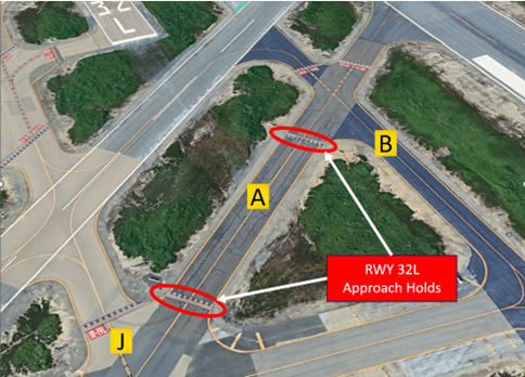
- The RWY 32L Approach Holds are located on TWY A between TWYs J and B and do not require verbal authorization to cross UNLESS you are instructed to hold short.
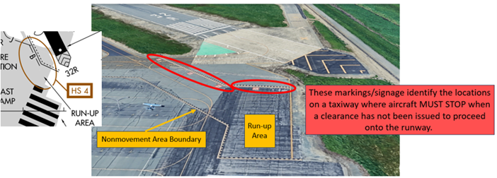
HS 4: Runway incursion risk. TWYs J, B and RWY 32R run–up area. Potential for expectation bias of run–up area location, and loss of situational awareness due to wide expanse of pavement.
- For all the above Hotspot descriptions, pilots should review the taxi clearance before starting to taxi.
- Actively scanning to locate and identify RWY signs, markings, lighting and deferring all heads down activities until holding short at the appropriate location will help eliminate these errors.
- If you are unsure of your position or instructions, ask the TWR.
Wrong Surface Risks
Arrival Alert Notices
- If available, back up all visual approaches with an instrument approach or GPS Waypoint to help ensure that you are lined up for the correct surface.
- RWY markings are white. Markings on surfaces not used for takeoff/landing like TWY markings, chevrons, RWY shoulder and RWY turn-on markings etc., are yellow.
- View the From the Flight Deck-Wrong Surface Landings video for additional mitigation strategies.
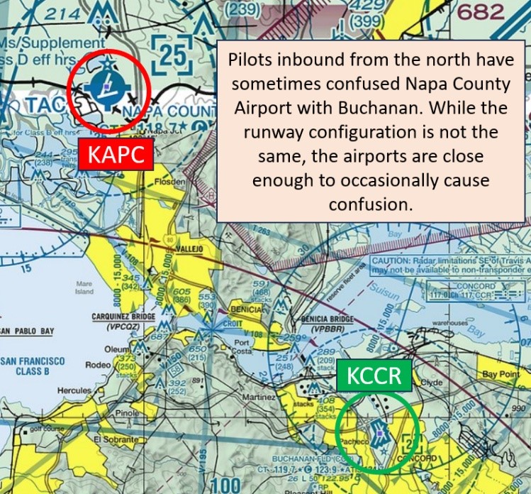
Wrong Airport Landing Risk
- During pre-flight planning, check the sectional chart for airports in close proximity and charted reporting points.
- Use the most precise navigational aids available such as GPS, localizers, or VOR radials to positively identify the airport.
- If you're talking to ATC and you're unsure, ask the controller.
- View the From the Flight Deck-Wrong Airport Landings video for more information and mitigation strategies.
Surface Movement Area Cautions
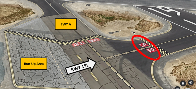
- Though not listed as a Hotspot, pilots in the run-up area for RWY 19L have mistaken TWY A for the runway.
- RWY 1R/19L pavement has high severity block cracking, longitudinal and transverse cracking, patching, and weathering.
General
- If you are unsure about any instructions, please ask for clarification.
- We do our best to accommodate all requests but sometimes we are unable due to traffic workload, complexity, or safety.
Traffic Patterns
- We try to accommodate pilots when they request the longer runway but these requests are dependent upon traffic.
- Please make the request for a short approach or early turnout before executing the procedure.
- We may be unable to accommodate short approaches with multiple aircraft in the pattern.
Ground
- On initial contact, please request the RWY that mostly aligns with your direction of flight.
- Read back ALL hold short instructions and ALL RWY assignments with your call sign.
- Ask for progressive instructions if you are unsure or unfamiliar.
- Stay on TWR frequency when in between active parallel RWYs.
Take-off/Departure
- Ask before you depart when requesting an early turnout.
- Depart in the direction that most aligns with your on-course heading.
- Be aware that IFR aircraft departing RWY 19R making a left downwind turn to the VOR will affect aircraft departing RWY 19L.
- Avoid crossing over any approach corridor without prior coordination with TWR.
Arrival/Landing
- For smoother handling, avoid calling at the Class D area boundary. Call earlier - at least 7 to 10 miles out.
- Do not mistakenly line up for RWY 14 when assigned RWY 19 or vice versa.
- Avoid crossing over the approach/departure corridor especially when on CCR is utilizing RWYs 1L/R.
- Be accurate and specific about your location, i.e., 10 miles north, northeast, east.
- When calling inbound, please be specific with your relative bearing from the airport.
- Listen to specific pattern entry instructions. We may need you to enter the downwind even though you are set up for a base entry.
- Remain on TWR frequency when in-between active parallel RWYs.
Avoidance Areas
- Aircraft that are requesting turns that cross the departure course or the final approach course for any runway should initiate that request with TWR prior to executing the turn.
- Be aware of noise abatement restricted areas.
- Noise abatement is for all aircraft. Find further information from the county’s website.