Chino Airport (CNO)
Chino Airport (CNO) in Southern California is located west of the city of Los Angeles, and three miles southeast of the city of Chino in San Bernadino County. It is the largest non-commercial airport within a 20-mile radius in this region making it a leading general aviation airport with a diverse mix of traffic and pilot experiences ranging from students to corporate pilots. View a printable Pilot Handbook of the CNO information found on this Web page.
Know Before You Go
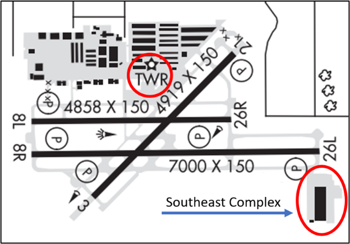
The RWY configuration consists of parallel RWYs 8L/26R and 8R/26L. A third RWY, designated RWY 3/21, intersects both parallel RWYs.
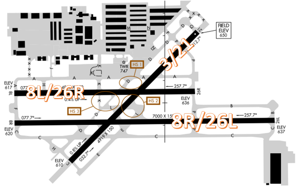
A complex system of TWYs connects all RWYs to businesses and facilities located mainly at the north end of the airfield.
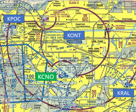
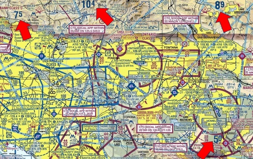
The airspace at CNO is Class D and underlies Ontario Class C airspace. (Refer to Sectional Chart.)
Tower Hours of Operation: 0700L-2100L
Administrative Office: 0800L to 1700L - M through F
Business Phone: 909-465-5201
Below find various CNO-specific information and things to be aware of, as well as general information to inform your preflight planning. This will be reviewed quarterly and updated as needed. This information is to supplement the From the Flight Deck Videos that are produced by the FAA Runway Safety Group. Here you will also find information provided by the local air traffic controllers at the airport where you intend to fly. The information is subject to change. Not for navigation or legal* pre-flight action. Always refer to official pre-flight materials such as, but not limited to, NOTAMs, airport diagrams, VFR charts and airport construction notices for the latest airport-specific details.
Hot Spots
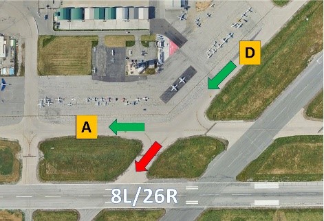
HS 1: Pilots taxiing south on TWY D, sometimes fail to turn onto TWY A and proceed onto RWY 8L/26R by mistake.
HS 2: Pilots taxiing west on TWY L, sometimes turn onto RWY 3/21 by mistake.
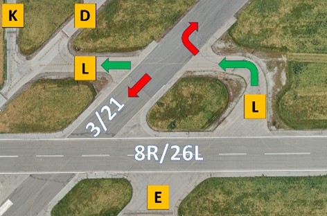
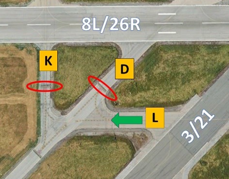
HS 3: Complex intersection – after crossing RWY 21 westbound on TWY L, pilots sometime confuse TWY D and TWY K and cross the 8L/26R RWY Holding Position marking without authorization.
Wrong Direction Intersection Takeoff
- View the From the Flight Deck-Wrong Direction Intersection Takeoffs.
- At CNO, or at any airport where intersection take-offs are authorized, there is the risk that pilots will turn in the wrong direction when entering the RWY.
- Prior to entering the RWY and again when lining up on the RWY, CHECK YOUR MAGNETIC COMPASS and HORIZONTAL SITUATION INDICATOR (HSI), if installed, to verify that you are pointed in the correct direction.
Wrong Surface Landing Risk
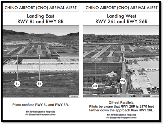
See Arrival Alert Notices (AAN)
- Wrong Surface Landing risk exists at CNO due to closely spaced parallel RWYs with staggered thresholds.
- Arrival Alert Notices (AAN) are graphics visually depicting an approach to a particular airport with a history of misalignment risk, and language describing the misalignment risk. (See illustration below.)
Additional Caution
- High Terrain – See Sectional Chart.
General Information
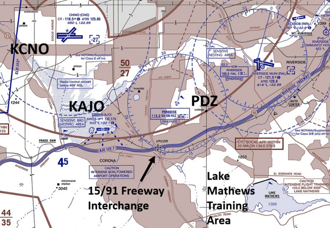
- Aircraft position reporting/instructions correlated to the local freeways are utilized extensively for day-to-day operations. Being familiar with them will help improve safety and efficiency.
- If CNO is utilizing separate tower frequencies for the runways, it will always be on the ATIS AFTER the landing/departing runway portion of the broadcast.
- Radio controlled aircraft activity below 400’ AGL 2.5 NM south of the airport.
Traffic Patterns
- Helicopter – 1,100’ MSL
- Single Engine – 1,400’ MSL
- Twin Engine/Jet – 2,000’ MSL
- Overhead – Conventional, flown to 3-5 mile initial at 2,000’ MSL, standard left or right break.
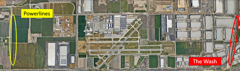
- Typical pattern upwind/downwind extensions used are the “wash” and the “powerlines”. If unfamiliar, make it clear to the Tower Controller and they will either call the turn or point out these areas.
- Majority of the year is sunny.
- Normally west flow on RWYs 26R/L but during the Santa Ana winds RWY 3/21 and RWY 8L/R operations are standard.
- Use caution, winds can exceed 30-40KTs.
Runway Crossings
- Crossing RWY 26R at TWY P, for a RWY 26L departure from TWY P is a common practice.
- Tower North will issue a hold short instruction and a frequency change to 120.12 to Tower South (if position is open).
- Pilots sometimes struggle with the frequency change (frequency technically 120.125) and/or,
- Mistakenly fail to cross the first set of hold short lines (RWY 26R hold bars on the South side).
- Be aware that TWY P between the parallels increases from 75’ to about 140’ in width. This leads to confusion due to signage being much farther away. Weeds sometimes obscure the signs.
- TWY L between the parallel RWYs is a hotspot that routinely leads to confusion.
- Controllers will alleviate this issue by having aircraft taxi straight ahead toward the windsock.
- If you are unfamiliar, advise Ground Control prior to taxi.
- When RWY 21 “North of TWY A” operations are in effect for helicopters, Pilots exiting the ramp will be issued taxi instructions RWY 26R that avoid the use of TWY P/RWY 21.
- Pilots sometimes question the crossing of RWY21 at TWY A because they see a helicopter operating on the runway.
- TWY A crossings are allowed, and the helicopter will be always restricted “North of TWY A”.
Departure
- IFR departures filed over PDZ, EXPECT POTENTAL DELAYS, especially on bad weather days.
Arrival/Landing
- When landing RWY 26L and exiting northbound on TWY P, make your intentions clear BEFORE turning onto the TWY.
- Due to Traffic volume, SoCal Approach may be unable to accommodate practice approaches. KCNO tower does not have the ability to influence this.
- Various reasons may require services to be reduced at times. The ATIS will reflect if pattern work/radar services are unavailable or limited.
 Student Solos/Instructor Drop Off
- Make it clear you want right or left closed traffic. TWR will accommodate, traffic permitting.
- Notify Ground Control if you need an instructor drop off. You will receive instructions to taxi to a non-movement area.
- Typical areas for drop off are at the base of the tower or the Southeast Complex (Threshold).
- Exiting the aircraft is at pilot’s own risk.
Helicopter Operations
- Helicopters landing at the base of the tower are expected NOT to overfly TWY D or A at low altitudes; this can lead to problems with ground traffic.
- If you need to overfly a taxiway, make your request to tower and the controller will accommodate accordingly.
- Departing from the base of the tower, pilot is expected to remain north of TWY A unless directed by the controller.
Congested Areas
- Lake Matthews practice area becomes heavily saturated during the day. Use extreme caution and monitor the appropriate frequency (123.5).
- The 15/91 freeway interchange is a busy area for outbounds/inbounds and a direct conflict with AJO practice approaches from PDZ. Recommend contacting CNO tower PRIOR to the 15/91 for proactive traffic calls/control.
- AJO is uncontrolled and can be busy at times. Use caution as these aircraft are not on CNO tower frequency.