
City of Colorado Springs Municipal Airport (COS)
City of Colorado Springs Municipal Airport (COS) is a public, civil-military airport located six miles southeast of downtown Colorado Springs, CO. Known as Colorado Springs Airport, it is the second busiest commercial service airport in the state after Denver International Airport. KCOS is home to Peterson Space Force Base, which is located on the north side of RWY 13/31. KCOS has a diverse mix of traffic with fast-moving military aircraft, commercial airlines, itinerant GA aircraft, medevac helicopters and flight school pattern traffic. GA services are primarily located on the west side of the airport. View a printable Pilot Handbook of the COS information found on this Web page.
Know Before You Go
COS Tower Hours of Operation: Continuous
Administrative Office: Open 0700L to 1600L M-F
Business Phone: 719-380-6700
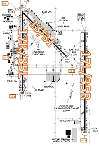
The airport configuration consists of widely spaced parallel RWYs 17R/35L and 17L/35R along with RWY 13/31.
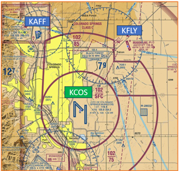
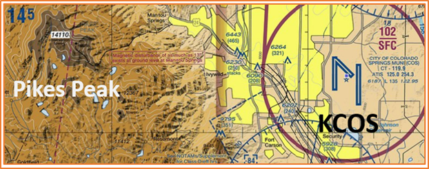
The airspace at COS is Class C. (Refer to Sectional Chart)
Hot Spots
HS 1: RWY threshold RWY 13 and RWY 17R are next to each other; wrong RWY departure and landing potential. RWY 17R connector TWY B1; tower line of sight limited. Maintain close communication with ATCT when in this area.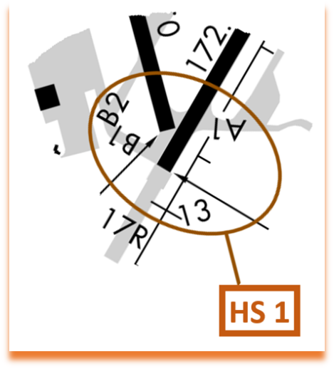
- At HS 1, a Wrong RWY Landing risk exists due to the proximity of the approach ends of RWY 17R and RWY 13.
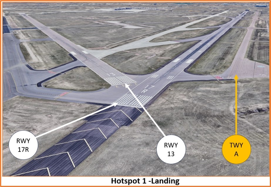
- Expectation bias or just lining up on the first RWY pilots see can lead to wrong surface landings.
- Verify that heading on final aligns with the assigned landing RWY.
- Both RWY 17R and RWY 13 can be accessed by TWY B1, which can potentially lead to a Wrong RWY Departure.
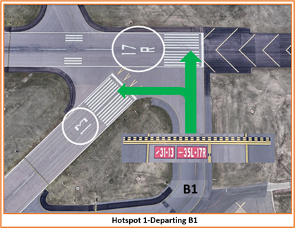
- Limited TWR line of sight in this area may affect the controller’s ability to see exactly which surface a small aircraft is using.
- Verify proper heading prior to starting takeoff roll. When lining up from TWY B1, check the RWY designator to make sure you are on the correct RWY.
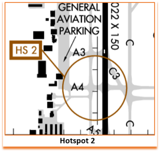
HS 2: Intersection of TWY A4 and TWY G at RWY 17R/35L: "High volume" crossing point.
- When exiting 17R/35L at A4, be aware of aircraft holding on TWY A waiting to cross the RWY.
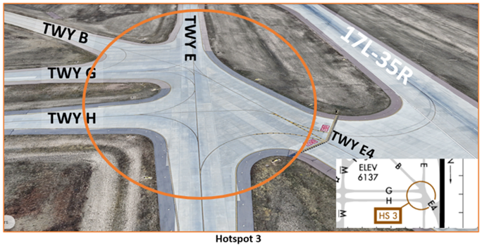
HS 3: Large concrete area at the intersection of TWY E4, TWY G, TWY H and TWY E. High risk of entering wrong TWY.
- When exiting RWY17L/35R at E4, be aware of aircraft taxiing on TWY B, TWY G, or TWY H that are joining TWY E. The convergence of these TWYs and the large expanse of concrete in this area may be confusing. Elevated TWY signage will assist pilots in navigating this area.
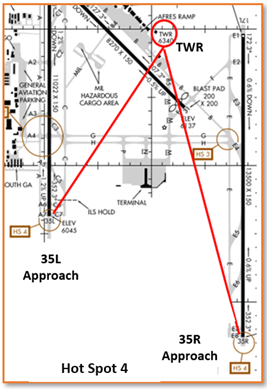
HS 4: The approach ends of RWY 35R and RWY 35L are very far from the control tower. Small aircraft may not be readily visible to the controller. Maintain strict communication with ATCT when in this area.
Wrong Surface TWY Landing
- Whenever a TWY runs parallel to a RWY, the risk of a TWY landing increases.
- The COS RWYs are widely spaced and expectation bias may lead to the assumption that a parallel TWY is the parallel RWY.
- If available, back up all visual approaches with an instrument approach to help ensure that you are lined up for the correct surface.
Additional Cautions
- Pay close attention to Density Altitude.
- COS Field Elevation is 6,147’ MSL.
- The Rocky Mountain Range is immediately west of COS.
- Pikes Peak (14,110’ MSL) is approximately 18 miles west of COS.
Traffic Patterns
- The local traffic pattern is as follows; helicopters 500 ft AGL (6700 MSL), Propeller-driven aircraft 1000 AGL (7200 MSL), large and turbine powered aircraft 1500 AGL (7700 MSL), and the overhead pattern is 2000 AGL (8200 MSL). Helicopters requesting higher than 500 AGL for auto-rotations must make the request with TWR.
- COS parallel RWYs are very widely spaced and the area between the parallels is often used as a downwind by TWR to transition aircraft from one parallel RWY to the other.
- Review NOTAMS for the Letter to Airmen LTA-COS-11 on “Traffic Pattern Operations Between the Parallel Runways” for more detailed information.
Ground Control
- Ground Control (GC) and Clearance Delivery are frequently combined. This may result in multiple aircraft calling one controller that is working two frequencies.
- Pilots may hear a controller make a transmission without a response from the aircraft on the other frequency. Wait and listen for your call sign.
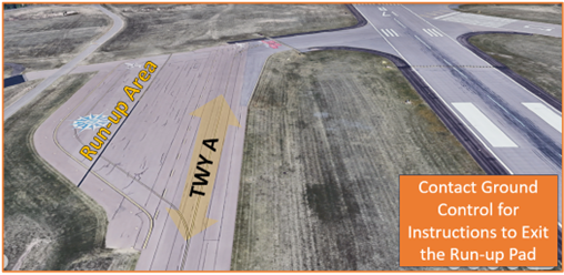
- If a run-up is needed, pilots should make the request with GC and taxi instructions to the Run-up Area will be issued by the controller.
- The only Run-up Area available near a runway is located near the approach end of RWY 17R.
- Once the run-up has been completed, contact GC for instructions.
Runway Crossings
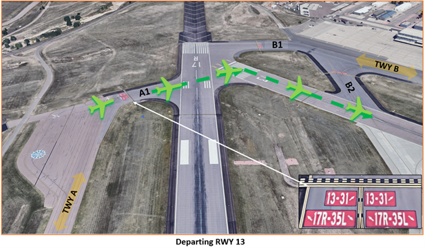
- We try to keep RWY crossings to a minimum, but they are sometimes unavoidable. A common RWY crossing we use is when an aircraft is ready to depart RWY 17R at TWY A1. We may instruct the pilot to cross RWY 17R to depart from RWY 13.
- This is used when the pattern is full, and we want to keep the flow of traffic moving
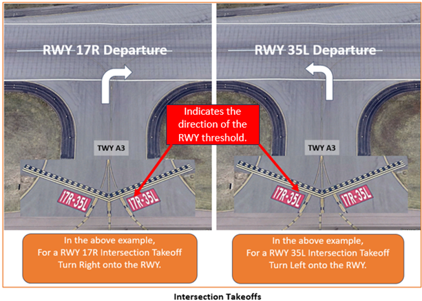
Takeoff/Departure
- Our runways are very long, and intersection departures may be disorienting for pilots.
- Ensure that you are facing the correct direction for the RWY you intend to depart. (RWY 17R at TWY A3 has 4300 feet remaining and RWY 35L at TWY A3 has 6300 feet remaining).
- Prior to entering the RWY and again when lining up on the RWY, check your Magnetic Compass and your Horizontal Situation Indicator (HSI), if installed, to verify that you are pointed in the correct direction.
Arrival/Landing
- General aviation aircraft will typically arrive and depart RWY 17R/35L.
- COS TWR/Approach Control will provide IFR separation to VFR aircraft conducting practice instrument approaches. Review NOTAMS for the Letter to Airmen LTA-COS-13 on “VFR Practice Approaches” for more information.
Weather
- COS experiences all forms of seasonal weather including thunderstorms with hail, snow, and freezing drizzle.
- CAUTION: RWYs can have opposing Low Level Wind Shear crosswinds due to funneling winds from mountain passes.
Avoidance Areas
- R2601 is restricted airspace starting approximately 10NM southwest of COS in the vicinity of Butts Army Airfield (Ft. Carson) (FCS). R2601 is split into three different stratums and can be identified in the NOTAMS as R2601A, R2601B and R2601C.
- R2602 is restricted airspace approximately 10NM east of COS. It is always active at and below 1,000 AGL.
- During college football season, the FAA may issue Temporary Flight Restrictions (TFRs) over the Davis Airfield (AFF) Class D airspace.
Special Traffic (Military / Commercial / Helicopter, etc.)
- During the warmer months, we have many hot air balloon operations in the vicinity of COS and over the city of Colorado Springs. Balloonists do not always call prior to departure and may appear without notice.
- Be aware of the large glider presence at AFF and Meadow Lake Airport (FLY).
Additional Information
- There are several smaller airports in the vicinity. Ensure that you have COS in sight when inbound.
- COS has a high volume of training aircraft. Situational awareness and patience are appreciated!