
Columbus Airport (CSG)
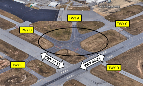
Columbus Airport (CSG) is a small to medium sized, primarily general aviation airport in Columbus, GA. Along with itinerant business aircraft, it also serves commercial and occasional military flights. It is located on the north end of the city of Columbus. CSG is 10 miles north of the Lawson Auxiliary Airfield. Fort Benning and its associated restricted airspace begins just 3.5 miles south of Columbus. The runway configuration consists of two intersecting RWYs - RWY 13/31 and primary use RWY 06/24. Full-length parallel taxiways provide access to the full length of all RWYs.
Know Before You Go
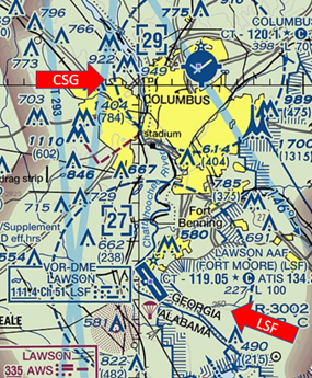
The airspace at CSG is Class D with a ceiling up to and including 2900’ MSL. (Refer to Sectional Chart)
View a printable Pilot Handbook of the CSG information found on this Web page.
Below find various CSG-specific information and things to be aware of, as well as general information to inform your preflight planning. This will be reviewed quarterly and updated as needed. This information is to supplement the From the Flight Deck Videos that are produced by the FAA Runway Safety Group. Here you will also find information provided by the local air traffic controllers at the airport where you intend to fly. The information is subject to change. Not for navigation or legal* pre-flight action. Always refer to official pre-flight materials such as, but not limited to, NOTAMs, airport diagrams, VFR charts and airport construction notices for the latest airport-specific details.
CSG Tower Operates: 0900L to 2100L Daily
Administrative Office: Open 0900L to 1700 L – Monday through Friday
Business Phone: 706-649-7779 Ext 3501
Hot Spots
HS 1: Remain vigilant converging TWY geometry.
HS 2: Remain vigilant to directional signage and pavement markings in the area.
Departure
- Verify proper heading prior to starting takeoff roll on all departures.
- Wrong surface takeoff risk exists here.
- Full-length parallel taxiways may lead to some confusion.
Landing
- Wrong Surface Landing risk exists here.
- Full-length parallel taxiways may lead to some confusion.
- CSG is 10 miles north of the Lawson Auxiliary Airfield (LSF). Caution – Wrong Airport Landing risk.
Surface Risk – Movement Area
- Hot Spot 1 is located where TWYs A, C and D come together to the north of the intersection of both RWYs.
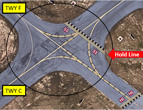
- Hot Spot 2 is located at the intersection of TWY C and TWY F. Pilots that are instructed to hold short of RWY 13/31 sometimes miss the markings and signage.
- A specific clearance is required to cross any RWY, active or not.
- Numerous RWY incursions have occurred at both hot spots.
- Pilots cleared to RWY 06 via TWY C have failed to hold short of the ILS Critical Area when instructed to do so by TWR.
- The RWY 06 ILS Critical Area is located on TWY C just west of TWY F.
- Aircraft parked on the north side of the airport must receive ATC clearance prior to taxiing onto a movement area.
- Non-movement area boundary markings are not present at various ramp areas and taxi-lanes.
- When leaving ramp areas, contact TWR prior to entering any TWY.
Additional Cautions
- Fort Benning and its associated restricted airspace begins just 3.5 miles south of Columbus.
- Pilots approaching from the east and south must remain aware of this airspace to avoid possible conflicts.
General
- Contact TWR when within 15 miles inbound. There is no need to contact us earlier.
- TWR is responsible for and will provide traffic separation only within the CSG Class D Airspace.
Traffic Patterns
- Advise TWR of your intentions when inbound or already in the traffic pattern.
- Expectation Bias will cause a pilot to hear what he/she is expecting and NOT the TWR’s actual clearance or instruction. Actively listen to TWR’s clearance and execute TWR’s instructions.
- Do not drop the word “Request” if you wish to change your intentions in the traffic pattern. Clearly state “Request” when asking for a new clearance.
- Do not change your instructions without an amended clearance from TWR.
- If in doubt about your clearance, make the request again with TWR and the controller will restate the clearance.
- Acknowledge all clearances with your call sign.
Ground
- State current position and ATIS code on initial contact and then state your request after establishing contact.
- Remember that VFR Flight Following is not the same as a VFR service request.
- You must specifically request VFR Flight Following with your Destination (3-letter identifier) and requested altitude.
- If requesting VFR only (no services) state direction of flight.
- When calling between the hangars radio transmissions are garbled and unreadable.
- When calling for taxi either be on the General Aviation open ramp or as far up on the non-movement area as possible without blocking inbound or outbound traffic.
- When acknowledging RWY crossing instructions, make sure your read-back includes your call sign, the crossing RWY, and the point of crossing.
Take-off/Departure
- When advised to hold short of the runway, restate “Hold short runway (#) (at (intersection) if not full length)” with call-sign. Read-back is not valid without call-sign and point of holding.
Arrival/Landing
- When exiting the runway pull all the way past the hold short line and contact ground. This line is intended to keep you out of the Runway Safety Area.
- When exiting the runway DO NOT TAXI WITHOUT INSTRUCTIONS.
- State parking request on initial contact by specifying your FBO or the Columbus Aero Service (CAS).
- If parking in a private hangar state either the “Foxtrot” or “Delta” TWY side so TWR can plan your RWY exit direction. This corresponds to the identification letter of the parallel TWY.
- Some pilots provide hangar numbers, but TWR does not know where those hangars are located on the airport.
- There is no access to the north general aviation (GA) ramp via TWYs A or C.
- The GA Ramp is only accessible via TWYs D1, D2, D3 or D4. This is due to a chain-link fence that separates the GA ramp and the commercial aviation security area.
Special Traffic (Military / Commercial / Helicopter, etc.)
- There is an Aerobatic Box directly over the airport.
- Dimensions are 1 NM radius of CSG.
- Extends from the surface to 3500’.
- When this box is active, TWR will restrict the aerobatic aircraft to remain north of RWY 06/24 to accommodate all traffic on that RWY.
- Piedmont Hospital is located 2NM SW of CSG, approximately on a 2-mile final for RWY 06. Expect low level helicopters arriving / departing that area.
- Helipad located near hangar on NW side of GA Ramp.
Avoidance Areas
- When the Aerobatic Box over CSG is active, please read back “Remain outside of the restricted area”.
- If unfamiliar, advise the TWR and we will give you suggested headings.
Additional Information
- No runways have an over-run.