David Wayne Hooks Memorial Airport (DWH)
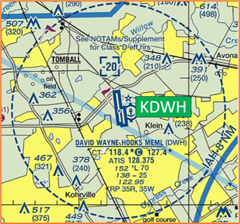
David Wayne Hooks Memorial Airport (DWH) is a primarily general aviation airport near the city of Tomball in unincorporated Harris County, Texas. It is located about 23 miles northwest of Houston's central business district and about 10 miles northwest of George Bush International Airport in Houston. View a printable Pilot Handbook of the DWH information found on this Web page.
Know Before You Go
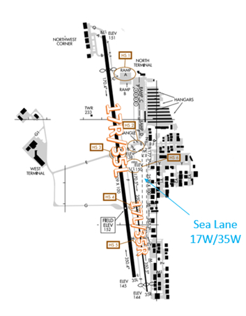
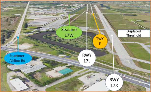
- The airport configuration consists of closely spaced parallel RWYs 17L/35R, 17R/35L and Sea Lane labeled 17W/35W.
- The airspace at DWH is Class D and underlies Houston Class B airspace. (Refer to Sectional Chart)
Below find various DWH-specific information and things to be aware of, as well as general information to inform your preflight planning. This will be reviewed quarterly and updated as needed. This information is to supplement the From the Flight Deck Videos that are produced by the FAA Runway Safety Group. Here you will also find information provided by the local air traffic controllers at the airport where you intend to fly. The information is subject to change. Not for navigation or legal* pre-flight action. Always refer to official pre-flight materials such as, but not limited to, NOTAMs, airport diagrams, VFR charts and airport construction notices for the latest airport-specific details.
DWH Tower Operates: 0700L-2200L
Administrative Office: Open 0700L-1500L M-F
Business Phone: 281-376-9721
Hot Spots
HS 1: RWY Incursion Risk– Ramp accessible to inadequately trained drivers; inadequate signage leaving ramp.
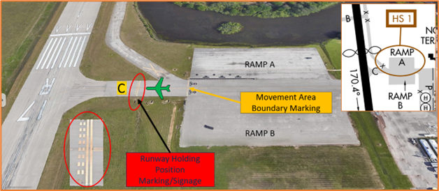
- Not only is HS 1 an issue for vehicle operators but it also concerns aircraft taxiing from any of the ramp areas to RWY 17R via TWY C.
- Aircraft have taxied across the RWY 17R/35L Hold Short Line on TWY C without clearance. Pilots need to be aware of the short distance between Ramps A and B and RWY 17R/35L.
HS 2: RWY Incursion Risk– Complex TWY Intersection near RWY 17L.
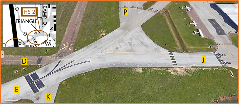
- This area is referred to as the “Triangle” and has resulted in some confusion due to the complexity of the pavement at this location.
- Pilots should review the taxi clearance before starting to taxi. Actively scanning to locate and identify RWY signs, markings, and lighting and deferring all heads down activities until holding short at the appropriate location will help eliminate these errors.
HS 3: RWY Incursion Risk – Previous Incursions occurring TWY E at RWY 17R/35L.

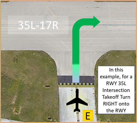
- At DWH, or at any airport where intersection take-offs are authorized, there is the risk that pilots will turn in the wrong direction when entering the RWY.
- Prior to entering the RWY and again when lining up on the RWY, check your Magnetic Compass and, your Horizontal Situation Indicator (HSI), if installed, to verify that you are pointed in the correct direction.
- View the From the Flight Deck-Wrong Direction Intersection Takeoffs video for more information and mitigation strategies.
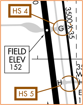 HS 4: RWY Incursion Risk – Intersection of TWY G and RWY 17L/35R. Aircraft exiting RWY 17R/35L at TWY G sometimes fail to turn onto TWY F and enter RWY 17L/35R without a clearance.
HS 5: RWY Incursion Risk – Intersection of TWY H and RWY 17L/35R. Aircraft exiting RWY 17R/35L at TWY H sometimes fail to turn onto TWY F and enter RWY 17L/35R without a clearance.
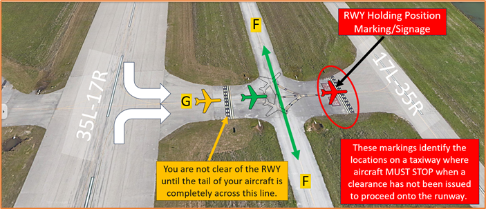
- HS 4 and HS 5 have essentially the same issue with aircraft exiting RWY 17R/35L with instructions to turn onto TWY F.
- Pilots have missed the turn and taxied onto RWY 17L/35R resulting in a runway incursion.
- Pilots should thoroughly review expected taxi routes and the overall airport configuration prior to their arrival.
- If you are ever unsure of your instructions or your position, ask the TWR.
HS 6: RWY Incursion Risk – Incursions occurring on TWY K at RWY 17L.
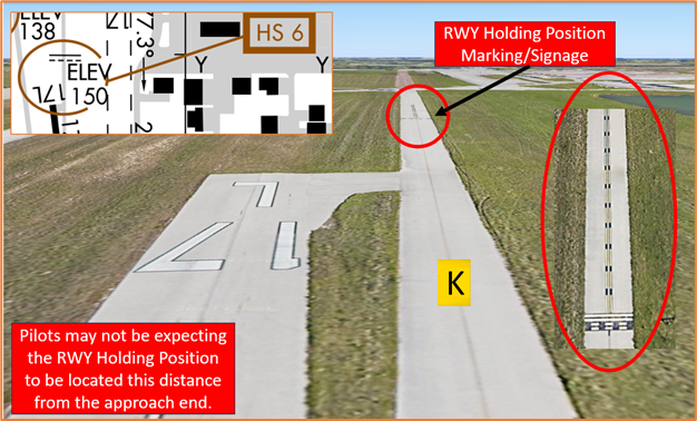
- The RWY Hold Short Markings for RWY 17L on TWY K are located farther from the approach end of the RWY.
- Pilots taxiing to RWY 17L may miss the hold short line resulting in a runway incursion.
- If you are ever unsure of your clearance or position, ask the TWR.
- View the From the Flight Deck – Complex Airfield Geometry#7: Hold Short Lines In Unexpected Places for additional information.
Wrong Runway Landing Risk
- Closely spaced parallel RWYs with full length parallel TWYs increase the risk of wrong surface landings.
- DWH RWY 17R/35L is twice the length and nearly three times the width of RWY 17L/35R. RWY 17R also has a 1007’ displaced threshold. The portion of RWY behind a displaced threshold is available for takeoffs in either direction or landings from the opposite direction. It is the largest RWY at DWH.
- RWY 17L/35R is similar in appearance to the parallel TWY F and can be mistaken for a RWY.
- Remember, RWY Markings are white. Markings on surfaces not used for takeoff/landing like Taxiway Markings, Chevrons, RWY Shoulder and RWY Turn-on Markings etc., are yellow.
- Stuebner Airline Rd. is located just east of the airport and may cause some confusion for pilots especially at night.
- When available, back up all visual approaches with an instrument approach or GPS to help ensure that you are lined up for the correct surface.
- If you are ever unsure of your clearance or position, ask the TWR.
- View the From the Flight Deck – Wrong Surface Landings video for mitigation strategies.
Traffic Patterns
- Traffic patterns are directed by TWR at controlled airports when TWR is in operation.
- When TWR is closed conduct Right Traffic Pattern on RWYs 35R and 35W.
Ground Control (GC)
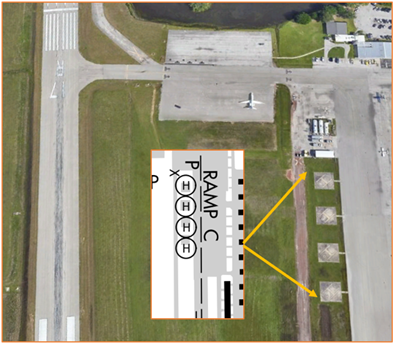
- Run-ups can be conducted on Ramps C or D. Run-ups may be conducted in other areas with prior approval from GC.
- Request clearance into Class “B” airspace or VFR Flight Following on initial call to GC.
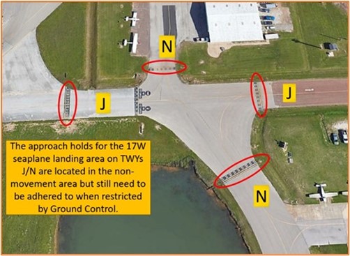
- The intersection where TWYs P, E, J and K meet is referred to as the “triangle.”
- Pilots should be aware of the Approach Holds for the 17W Seaplane landing area and be prepared to hold short when instructed.
Takeoff/Departure
- Normally, there is only one tower frequency (118.4) in operation but with increased traffic or for training purposes, TWR will open a second frequency (127.4)
- Remain below Houston Class B airspace until receiving ATC clearance.
- Do not leave TWR frequency prior to departing DWH airspace unless approved by TWR.
Arrival/Landing
- TWR will usually keep touch-and -go traffic on the east side of the airport.
- Most arrivals, departures, and transitioning aircraft will remain on the west side.
- VFR aircraft executing practice instrument approaches will be provided IFR separation, to the extent possible, by Houston TRACON. Pilots should review the Letter to Airmen LTA-I90-13 for specific information.
Special Traffic (Military / Commercial / Helicopter, etc.)
- There is a practice area for helicopter training on the west side of the airport at or below 600’ AGL.
- The helicopter practice area is an enclosure roughly bound by TWY E to the south, Boudreaux Road to the northwest, and the Control Tower to the east.
- Helicopters are instructed to conform their traffic flow to the fixed wing traffic flow and are restricted to an altitude no higher than 800 feet AGL (952 feet MSL).
- Fixed-wing pilots entering the pattern on the west side of the airport should ensure proper pattern altitude to maintain separation from helicopters in the practice area.
- Four helicopter parking spots are located near Ramp C east of RWY 17R.