Danbury Municipal Airport (DXR)
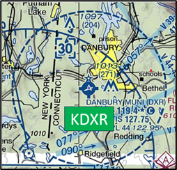
Danbury Municipal Airport (DXR) is a primarily general and business aviation airport located southwest of the city of Danbury, Connecticut. While the bulk of the traffic is general aviation, DXR does have some air taxi operations as well as several flight schools offering fixed and rotor wing instruction. DXR is geographically located in a “bowl” with higher terrain surrounding it. View a printable Pilot Handbook of the DXR information found on this Web page.
Know Before You Go
DXR Tower Operates 0700L-2200L
Administrative Office Open 0800L-1600L M-F
Business Phone 203-748-6375
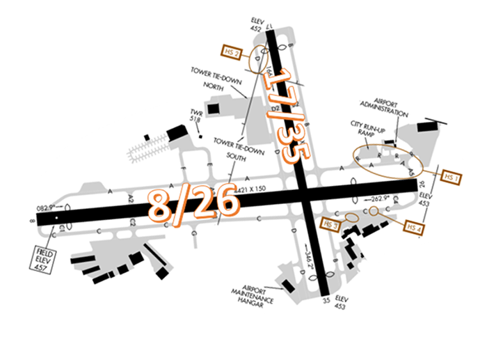
The airport configuration consists of intersecting RWYs 8/26 and 17/35 with full length parallel TWYs on either side of both RWYS. The TWY system provides access to all services, hangars and numerous FBOs located in all four quadrants of the field.
The airspace at DXR is Class D. (Refer to Sectional Chart)
Hot Spots
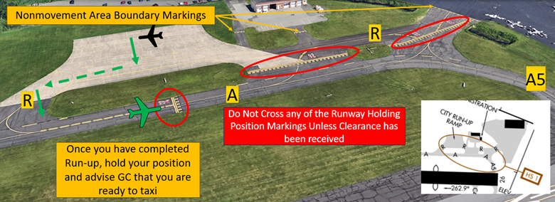
HS 1 Maintain vigilance confusing TWY configuration. Pilots unfamiliar should ask for progressives.
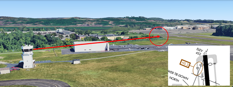
HS 2 Area not visible from the TWR.
- To mitigate this situation, the airport has installed a camera to provide controllers with a view of traffic in this area. However, due to weather or technical issues, this camera may not be operating or useful at all times, so pilots should assume that the non-visibility factor is always considered in this area. Tower may ask for more accurate position reports under these conditions.
HS 3 Active ramp adjacent to TWY.
HS 4 Hold position marking on TWY C for RWY 26 is further from the RWY than the standard location. It will appear before you expect it.
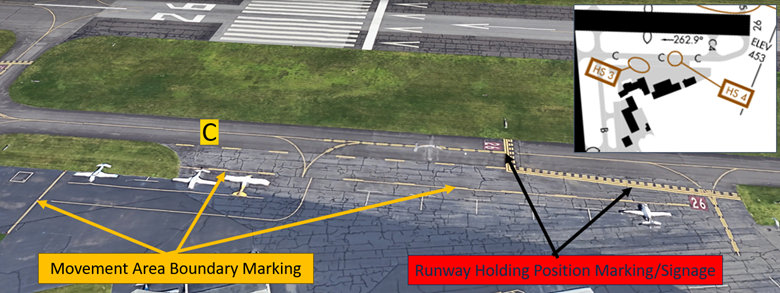
- Hot spots 3 and 4 concern the same issue. There is a large ramp area utilized by several FBO’s. There is no dedicated run-up area for this portion of the field. Aircraft exiting the ramp will sometimes do their run-ups on TWY C creating congestion.
- RWY Safety Area requirements call for the hold short markings to be located a considerable distance back from the approach end of RWY 26. If you are unsure of your clearance or position, ask the TWR.
- View the From the Flight Deck - Complex Airfield Geometry#7: Hold Short Lines In Unexpected Places for additional information.
Traffic Patterns
- Standard traffic patterns for all RWYs are left turns. Pattern altitude 1700 MSL for single engine propeller, 2200 MSL for twin engine/jet aircraft.
Ground Control (GC)
- Pilots requesting a squawk code for flight-following should do so on 121.6 prior to taxi. Provide destination, type aircraft and requested altitude.
Takeoff/Departure
- IFR aircraft departing RWY 8 will be issued a left turn direct CMK VOR.
- Pilots are requested to turn crosswind after passing 1200ft when departing RWY 8. When safe to do so, turn crosswind as soon as possible when departing RWY 26. When departing RWY 17 a left crosswind turn should be made south of Lake Waubeeka, 1.5NM SSE of DXR. When departing RWY 35 turn crosswind when crossing Route 84.
Arrival/Landing
- Pilots should review the voluntary noise abatement procedures found in NOTAMS Letter to Airmen: LTA-DXR-17 “VFR Flight Near Noise Sensitive Areas”.
- When arriving RWY 35 from the right downwind, pilots are requested to turn base south of Lake Waubeeka for voluntary noise abatement.
- Pattern areas of non-visibility from the tower include left base RWY 26, right and left base RWY 35 as well as portions of final for RWY 35.
- Instrument approaches (RNAV A, RNAV 26, LOC 8, RNAV-Y 8, RNAV-Z 8) circling south of RWY 8/26 not authorized.
- Instrument approaches (RNAV A, RNAV 26, LOC 8, RNAV-Y 8, RNAV-Z 8) not authorized at night.
Weather
- Weather information is available via ATIS/ASOS on 127.75. Arriving aircraft may not receive if inbound from the south at low altitude (below 3000 MSL). When we update the ATIS, it needs to be taken offline. If you are within reception range and do not hear the ATIS, it is likely being updated.
Avoidance Areas
- Avoid overflying the Lake Waubeeka community 1.5NM SSE of DXR.
