
Flying Cloud Airport (FCM)
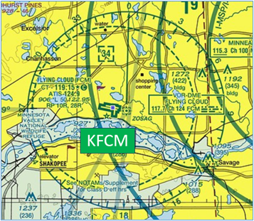
The Flying Cloud Airport (FCM) is a primarily business and general aviation airport located approximately 10 miles southwest of the larger Minneapolis-Saint Paul International Airport. FCM is one of several alternative reliever airports serving the metropolis of Minneapolis-Saint Paul. Numerous FBOs, hangars, flight schools, and businesses are located on the north side of TWY Alpha. The taxiway structure provides access to the facilities and hangars located primarily on the north and east sides of the airport. View a printable Pilot Handbook of the FCM information found on this web page.
Know Before You Go
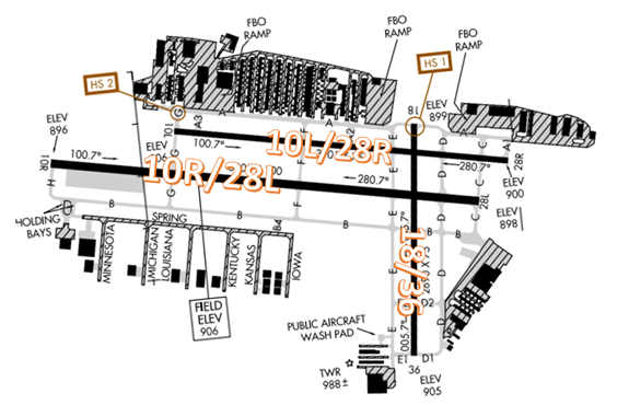
The RWY configuration consists of parallel RWYs 10L/28R and 10R/28L along with intersecting RWY 18/36.
FCM ATCT Operates: 0600L-2100L
Administrative Office: Open 0730L - 1600L M-F
Business Phone: 952-941-1188
The RWY configuration consists of parallel RWYs 10L/28R and 10R/28L along with intersecting RWY 18/36.
Note: FCM split local control North/South as of 4/1/26. Frequency 125.2 is used for RWY10L/28R arrivals and departures, and frequency 119.15 is used for RWY10R/28L arrivals and departures.
The airspace at FCM is Class D and underlies Minneapolis/St Paul Class B airspace. (Refer to Sectional Chart)
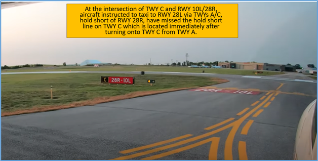
Hot Spots
HS 1: RWY 18 approach area proximity to adjacent ramps along TWY A.
- Pilots taxiing in either direction on TWY A sometimes miss the holding position markings when instructed to hold short of RWY 18.
- Surface painted markings (including enhanced centerline markings), elevated signage and wig-wag lights are present in this area.
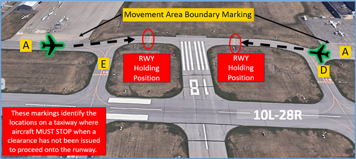
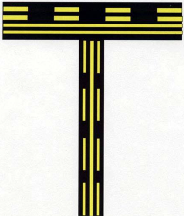
Note: The enhanced taxiway centerline marking consists of a parallel line of yellow dashes on either side of the normal taxiway centerline. The purpose of this enhancement is to warn the pilot that he/she is approaching a runway holding position marking and should prepare to stop unless he/she has been cleared onto or across the runway by ATC.
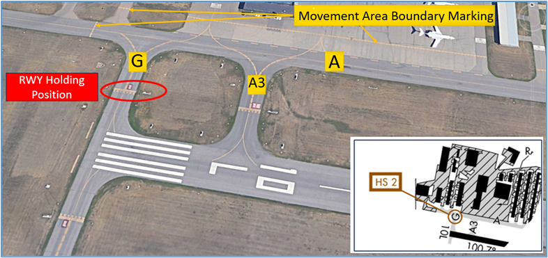
HS 2: Short taxi distance from ramp to RWY hold line.
- Pilots exiting the ramp area near the approach end of RWY 10L need to be aware of the proximity of the RWY hold short line.
- Pilots should review the taxi clearance before starting to taxi. Actively scanning to locate and identify RWY signs, markings, and lighting and deferring all heads down activities until holding short at the appropriate location will help eliminate these errors.
- View the From the Flight Deck - Complex Airfield Geometry#2: Short Taxi Distance From Ramp or Apron To Runway for additional information.
Wrong Surface Landing Risk
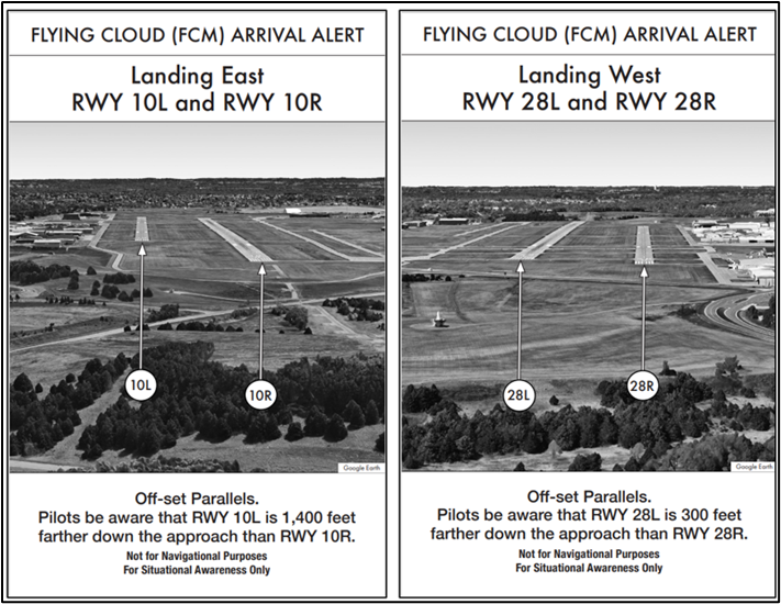
- Pilots cleared to land on either of the parallel RWYs have landed or attempted to land on the adjacent parallel RWY. See Arrival Alert Notices.
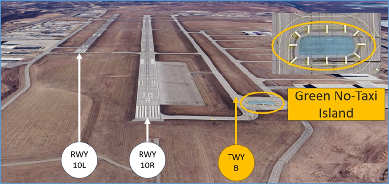
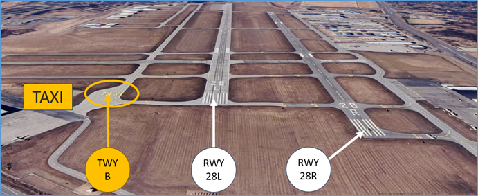
- Whenever a TWY runs parallel to a RWY, the risk of landing on a TWY increases.
- Pilots have mistaken TWY B for a RWY. To assist in mitigating this risk, the word “TAXI” has been painted on the east end of TWY B. On the west end of TWY B, a green “No-taxi” island has ben painted on the taxiway.
- When flying on left downwind for RWY 10L, the approach end of RWY 10L may not be visible causing pilots to mistake RWY 10R for RWY 10L, and TWY B for RWY 10R.
- The approach ends of RWY 28L and RWY 28R are at an angle to the Control TWR that makes it difficult for the controller to confirm that aircraft are lined up on the correct RWY.
- To help the confusion between parallel TWYs and RWYs, FCM has taken the following steps:
- 0R - MALSR is operated continuously.
- 10L/28R - REIL operated when tower is in operation.
- 28L- REIL is operated continuously.
- If available, back up all visual approaches with an instrument approach to help ensure that you are lined up for the correct surface.
- RWY markings are white. Markings on surfaces not used for takeoff/landing like TWY markings, chevrons, RWY shoulder and RWY turn-on markings etc., are yellow.
- View the From the Flight Deck - Wrong Surface Landings video for additional mitigation strategies.
Additional Cautions
General
- Please read back all RWY assignments and hold-short instructions with callsign.
- Pilots are expected to comply with “do not exceed 250 KTS below 10,000 feet” due to the wide mixed usage aircraft that operate within FCM’s airspace.
- RWY 10L/28R is closed when Tower is closed.
- FCM ATCT split local control North/South as of 4/1/26. Frequency 125.2 is used for RWY10L/28R arrivals and departures, and frequency 119.15 is used for RWY10R/28L arrivals and departures.
Traffic Patterns
- Numerous flight training operations are conducted from the four flight schools that operate at FCM.
- Traffic pattern direction will be issued by the TWR.
- Opposing base–leg traffic occurs when utilizing both parallel RWYs. Pilots should maintain vigilance to not overshoot when on base-legs.
Ground Control
- Contact Ground Control (GC) before you start taxiing to avoid conflicting with aircraft that are moving on the taxiways.
- Remain on GC frequency until at your assigned RWY as you taxi out unless advised to change to TWR frequency.
Takeoff/Departure
- VFR traffic-climb to 3,000ft as soon as practicable.
- FCM utilizes “Line Up and Wait” (LUAW) to instruct a pilot to taxi onto the departure RWY and hold position until cleared for takeoff. It is not authorization for takeoff. For mitigation strategies, view the From the Flight Deck - Line Up and Wait video.
Arrival/Landing
- After landing, remain on TWR frequency while between the parallels.
- VFR traffic-descend to 2,000ft as soon as practicable. With closely spaced parallels, try not to over-shoot finals from base turn. There may be traffic landing on the other runway at the same time.
- Minneapolis Approach will provide IFR longitudinal separation and/or a minimum of 500 feet vertical separation to VFR aircraft practicing instrument approaches to FCM. Review NOTAMS for the Letter to Airmen: LTA-M98-20 “VFR Practice Instrument Approaches” for more information.
- If you have questions are if you are not sure of your instructions, ask the TWR for assistance.
Avoidance Areas
- We recommend that you contact FCM ATCT if flying within 8 miles of the airspace- we may have traffic for you.