


Charleston International Airport (CHS)
Charleston Air Force Base/International Airport (CHS) is located between Summerville and Charleston, South Carolina. The traffic mix at CHS is the spectrum of the aviation community. Beware of jet blast, as well as high-speed, low level flight formations, miscellaneous air to ground drops and operations due to military presence. A large, restricted military ramp is located on the west side of the RWYs. View a printable Pilot Handbook of the CHS information found on this Web page.
Know Before You Go
CHS ATCT: Operates 24 Hours
Administrative Office: Open 0800L to 1500L-M-F
Business Phone: 843-414 -2800
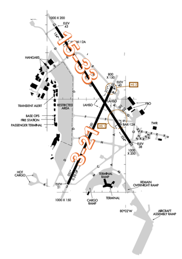
The RWY configuration consists of RWY 15/33 and RWY 3/21.
The airspace at CHS is Class C. (Refer to Sectional Chart.)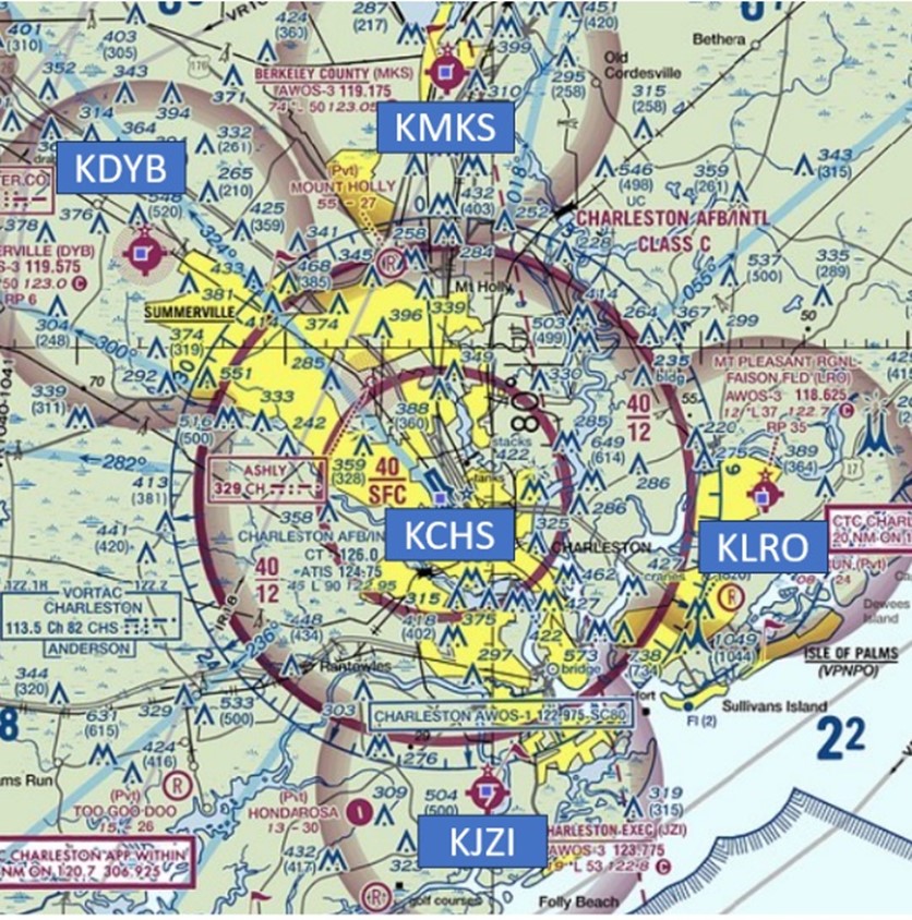
Hot Spots
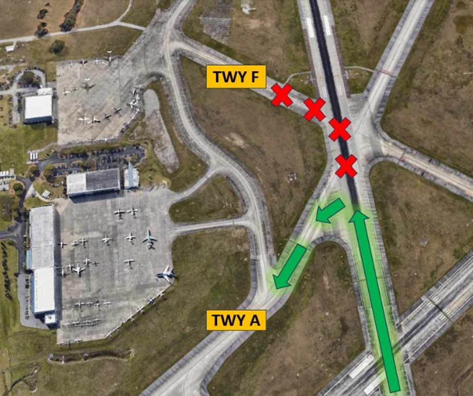
HS 1: TWY A and TWY F and RWY 15/33 confusing intersection.
- HS 1 can be confusing for pilots due to the large expanse of pavement. Pay close attention to TWY markings and signage in this area.
- General Aviation aircraft landing RWY 15 at night may have difficulty identifying and making the left turn onto TWY A to exit the RWY. Pilots often miss the turn to TWY A and turn onto TWY F. If you are unsure about your instructions, ask the TWR.
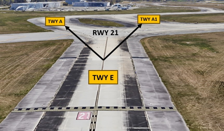
HS 2: Maintain vigilance when crossing RWY 21 to TWY A or TWY A1 from TWY E.
- Aircraft may be holding short at TWY A or TWY A1 for departure on RWY 21.
- If taxiing southbound on TWY E, TWR may clear you to cross RWY 21 and join TWY A or TWY A1, depending upon where TWR intends to hold departing traffic.
- If cleared to cross RWY 21, be sure to join the correct TWY on the other side.
Wrong Surface Landings
- Pilots should exercise caution with similar sounding RWY numbers when issued a landing clearance for RWY 3 or RWY 33. Pilots have attempted to land on the wrong RWY. For emphasis, CHS controllers sometimes refer to RWY 3 as RWY Zero Three.
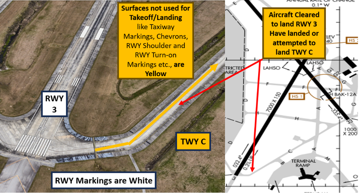
- An additional Wrong Surface Landing risk exists due to the proximity of the approach end of RWY 3 and TWY C.
- Pilots cleared to land on RWY 3 have landed or have attempted to land on TWY C.
- If available, back up all visual approaches with an instrument approach/GPS Waypoint to help ensure that you are lined up for the correct surface.
- Remember, RWY markings are white. Markings on surfaces not used for takeoff/landing like TWY markings, chevrons, RWY shoulder and RWY turn-on markings etc., are yellow.
- View the From the Flight Deck-Wrong Surface Landings video for additional mitigation strategies
Surface Risk – Movement Area Cautions
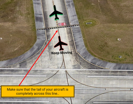
- When exiting the RWY, taxi without delay to cross the hold short line for the RWY behind you.
- Your aircraft is not clear until it is completely across this line.
- Delay can cause aircraft landing behind you to be issued go-around instructions.
General
- Due to the large number of jet aircraft that operate at CHS, pilots should always be aware of jet blast and maintain a safe distance.
Ground Control/Clearance Delivery
- Charleston Ground Control frequency is sometimes combined with Clearance Delivery frequency.
- This may result in multiple aircraft calling one controller that is working two frequencies.
- Pilots may hear a controller transmit without a response from the aircraft on the other frequency. Listen carefully for your call sign.
- VFR aircraft calling for flight-following or ATC services should phrase their initial transmission as “Charleston Clearance NXXXX VFR request”.
- Once initial contact has been established, aircraft should provide call sign, type aircraft, requested altitude, and VFR request.
- Pilots should avoid giving all information on the initial transmission. This may result in a “say again” from the controller.
RWY Crossings
- Remain on the TWR frequency after landing on RWY 3 or RWY 33 due to RWY crossings. Pilots should not switch to ground frequency until instructed to do so by the TWR.
- Aircraft must read back all hold short instructions.
Takeoff/Departure
- If assigned an RNAV departure, ensure that the appropriate departure RWY is loaded in the Flight Management System.
- A turn in the wrong direction can create a conflict for a simultaneous intersecting RWY departure.
Arrival/Landing
- VFR aircraft inbound for landing at CHS should make the following initial transmission: “Charleston approach, NXXXX VFR request”.
- After initial contact has been established, aircraft should provide call sign, type aircraft, position, and VFR request.
- VFR aircraft inbound for landing should avoid all RWY final approach courses when making initial contact.
- A good reference for aircraft requesting inbound for landing is 15NM from CHS and at or below 2,500 MSL.
- Land & Hold Short (LAHSO) clearances may be issued to general aviation aircraft. Student pilots please advise approach control if you are unable to participate.
| LDG RWY | HOLD-SHORT POINT | AVBL LDG DIST |
|---|---|---|
| RWY 03 | 15/33 | 5400 |
| RWY 15 | 03/21 | 5450 |
| RWY 33 | 03/21 | 2650 |
Special Traffic (Military / Commercial / Helicopter, etc.)
- Military “Overhead” maneuvers are frequent and are performed by multiple types of aircraft.
- It is a common occurrence for aircraft to perform this maneuver at 1,700 feet MSL over the RWY surface.
- Tower controllers are responsible for ensuring separation between this maneuver and other arrival aircraft so don’t be alarmed when traffic is issued over the top of your arrival or departure. If you have any questions, feel free to ask the controller.
Avoidance Areas 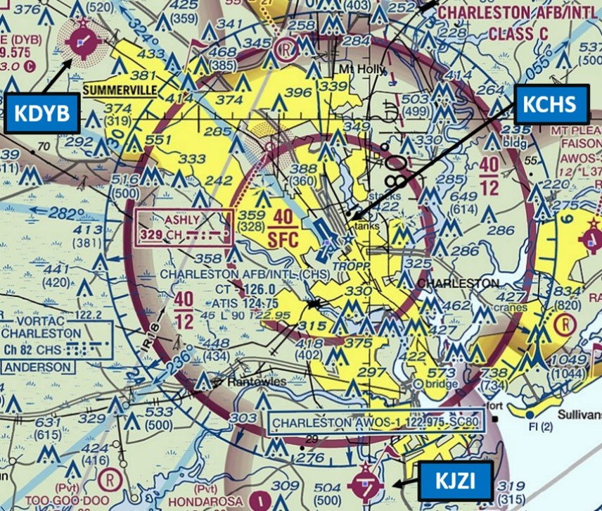
- DYB (Summerville Airport) and JZI (Charleston Executive Airport) are two satellite airports that are near the RWY 15/33 final approach courses.
- If VFR aircraft are operating in the vicinity of these two airports, an altitude of 2000 feet MSL or below is suggested to ensure separation with IFR aircraft inbound to CHS.
- IFR aircraft are usually at 3000 feet MSL in the proximity of these two airports.
- Pilots should review NOTAMS for Letter to Airmen: LTA-CHS-3 VFR In The Vicinity Of CHS for detailed information.
Additional Information
- Land and sea breezes are dominant at coastline airports and can change multiple times in a day. Aircraft should request a “wind check” from tower for the most up to date winds prior to landing.
- No student solo touch-and-go landings are allowed.
- RWY 15/33 has one-foot raised threshold lighting.
- Bird activity in the vicinity during migratory waterfowl periods.