
El Paso International Airport (ELP)
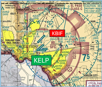
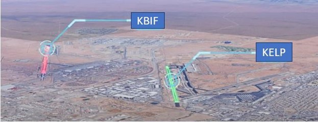
El Paso International Airport (ELP) is a multi-use airport located north and east of the city of El Paso, Texas. Pilots inbound for ELP should note that the airport is located only 3.5 miles north of the US/Mexico border. Biggs Army Airfield (KBIF) is less than two miles north of ELP. This warrants additional awareness because RWY 4/22 at KBIF can be mistaken for RWY 4/22 at ELP. View a printable Pilot Handbook of the ELP information found on this Web page.
Know Before You Go
ELP ATCT Operates: 24/7
Admin Office Open: 0730L to 1600L M-F
Business Phone: 915-774-9410
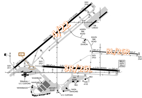
The RWY configuration consists of parallel RWY 4/22, RWY 8L/26R and RWY 8R/26L
The airspace at ELP is Class C. (Refer to Sectional Chart)
Pilots should review the Sectional Chart and be aware of the mountainous terrain in the area.
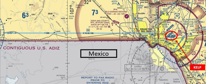
El Paso Class C Airspace borders the Contiguous U.S. Air Defense Identification Zone (ADIZ) This is an area of airspace over land or water, in which the ready identification, location, and control of all aircraft (except Department of Defense and law enforcement aircraft) is required in the interest of national security.
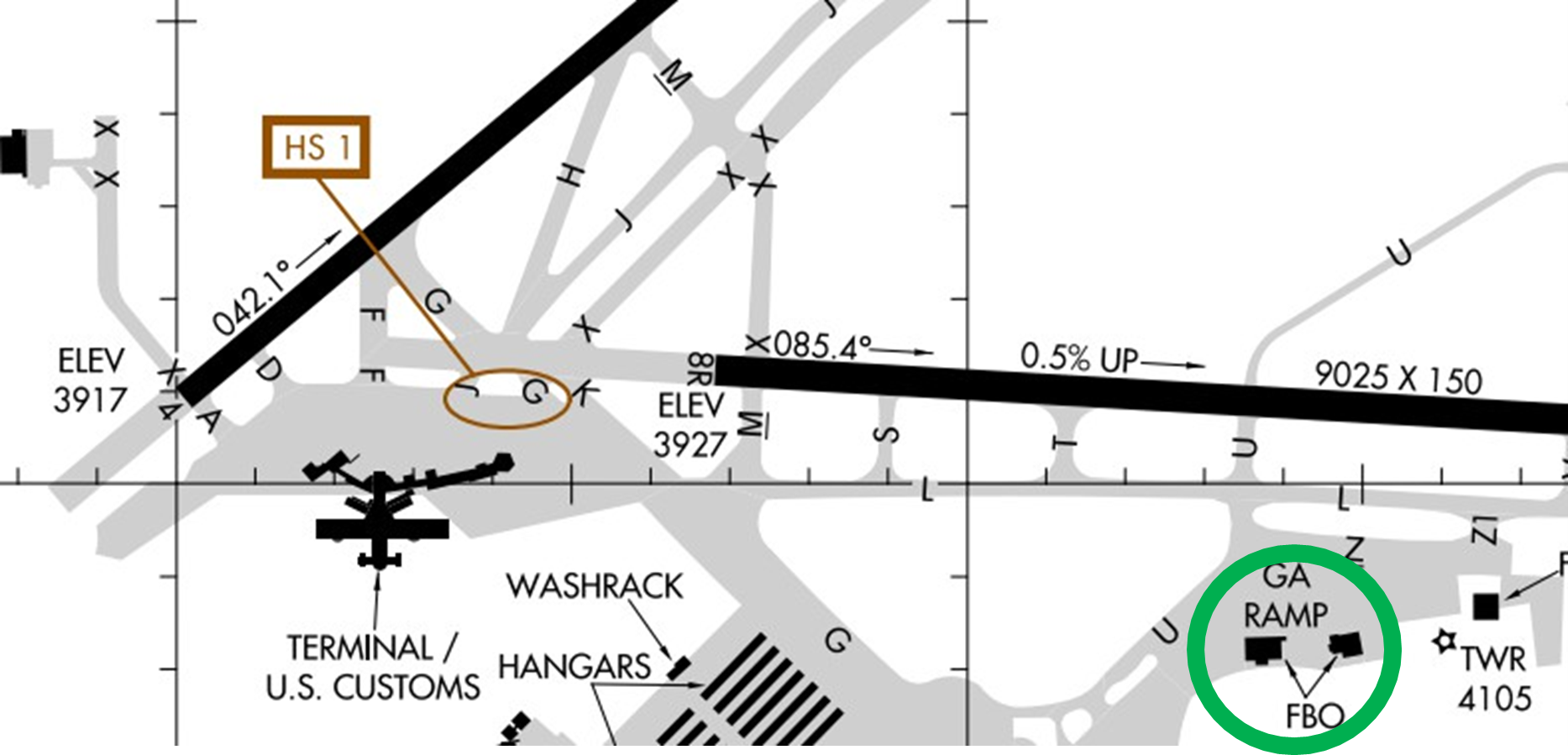
Hot Spots
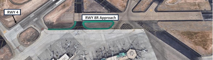
HS 1: RWY 8R approach considered active, do not proceed on or cross without ATC clearance especially when taxiing to RWY 4 via the terminal ramp.
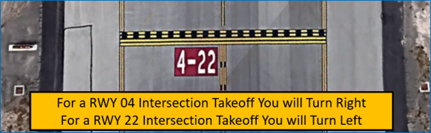
Wrong Surface Intersection Takeoffs
- Risk exists where pilots will turn in the wrong direction during Intersection Takeoffs.
- Always check the magnetic compass / Horizontal Situation Indicator (HSI) to confirm departure in the proper direction. (See illustration below.)

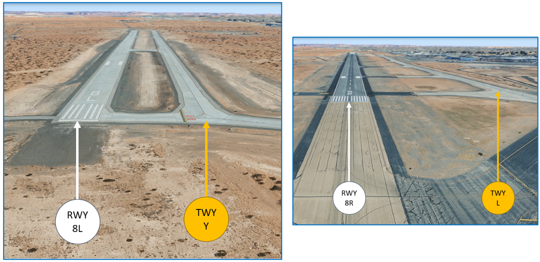
Wrong Surface Taxiway Takeoffs
- Pilots that have been cleared to land on RWY 26R or RWY 26L have landed or attempted to land on the wrong parallel runway,
- Whenever a taxiway runs parallel to a runway, the risk of landing on a taxiway increases.
- If available, back up all visual approaches with an instrument approach.
- Runway Markings are WHITE.
- Markings on Surfaces not used for Takeoff/Landing like Taxiway Markings, Chevrons, RWY Shoulder and RWY Turn-on Markings etc., are YELLOW.
- If available, back up all visual approaches with an instrument approach or GPS Waypoint to help ensure that you are lined up for the correct surface.
- View the From the Flight Deck-Wrong Surface Landings video for additional mitigation strategies.
Wrong Airport Landing Risk
- A Wrong Airport Landing risk exists between KBIF and ELP, especially when landing on RWY 4 or RWY 22. The airports are located only two miles apart and have a similar runway orientation.
Surface Risk - Movement Area Cautions
- There is a large complex area of concrete where several TWYs and an extended RWY centerline come together. Some pilots have been confused especially when taxiing from the general aviation (GA) ramp for takeoff on either RWY 4 or RWY 8R.
- Additionally, general aviation aircraft taxiing to RWY 4 from the east ramp may encounter congestion and confusion in this area.
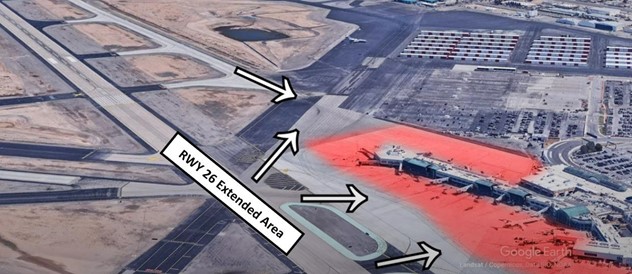
- There is a large, non-movement area surrounding the terminal where air-carrier aircraft push back from the gates. Pilots should use caution if rolling out on the RWY 26L extended runoff area.
General
- The RWY 8R Approach area is easily confused as several TWY’s converge onto the Terminal Ramp area. If you have any questions regarding taxi instructions, please verify with ATC prior to entering the RWY 8R Approach.
- It is important to note that the RWY 8R approach area serves as an overrun area for aircraft landing RWY 26L. If possible, you should avoid stopping in the RWY 8R approach area as it may initiate Go-Around instructions for aircraft on approach to the RWY.
- The approach ends of RWY 4/22 are not visible from the TWR. Transmit and receive radio issues sometimes occur at these locations.
Takeoff/Departure
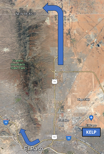
- ELP has two informal VFR departure areas known as the “Downtown” transition or the “Gap” Transition that are utilized to gain altitude above the Franklin mountains.
- The Downtown transition is a VFR departure to the Southwest over the downtown area of EL Paso. Once you feel confident in your ability to climb above obstructions you may continue westbound unless otherwise instructed by ATC.
- The Gap transition refers to the Anthony Gap which is the northernmost part of the Franklin mountains. Aircraft on the Gap transition should fly North westbound until they clear obstructions and then may continue westbound unless otherwise instructed by ATC.
Traffic Patterns
- Traffic pattern altitude for small, fixed wing traffic is 5000’ MSL.
- Traffic Pattern altitude for large aircraft is 5500’ MSL.
- Traffic Pattern altitude for jets is 6000’ MSL.
- Verify traffic pattern direction with ATC as there may be multiple aircraft in the pattern.
Arrival/Landing
- When inbound from the west, over downtown El Paso, contact Approach Control prior to the Class C Airspace for departure advisories.
- When inbound from the east, on the right downwind to runway 08R, use caution when turning base to Runway 8R, potential for WSL to RWY 04.
Special Traffic (Military / Commercial / Helicopter, etc.)
- The Southeast Practice Area is an area southeast of El Paso Class C airspace, east of the Mexican border, south of the ELP VORTAC 090 Radial and within approximately 30NM from the ELP VORTAC.
- Numerous government, military and medivac helicopters operate along the border west and east of El Paso.
Weather
- High winds are common during certain seasons and can gust up to 50-60 MPH, causing the dust to reduce visibility to zero. Additionally, during the Monsoon Season, rapidly building thunderstorms and high winds can develop causing visibility to diminish to zero.