
Montgomery-Gibbs Executive, San Diego, CA (MYF)
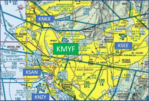
Montgomery-Gibbs Executive Airport (MYF) is located just six miles northeast of San Diego International Airport (SAN). Traffic consists of flight schools, business, and general aviation. The complex southern California airspace, including the San Diego Class Bravo and the Montgomery-Gibbs and Gillespie Field Class Delta, necessitates the requirement for unique arrival routes. View a printable Pilot Handbook of the MYF information found on this Web page.

Know Before You Go
MYF ATCT Operates: 0600L-2100L M-F
Administrative Office: Open 0800L to 1630L M-F
Business Phone: 858-277-5601
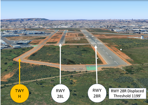
The RWY configuration consists of RWYs 5/23, 10L/28R, and 10R/28L.
The airspace at MYF is Class D and underlies San Diego Class B airspace (See Sectional Chart).
Hot Spots
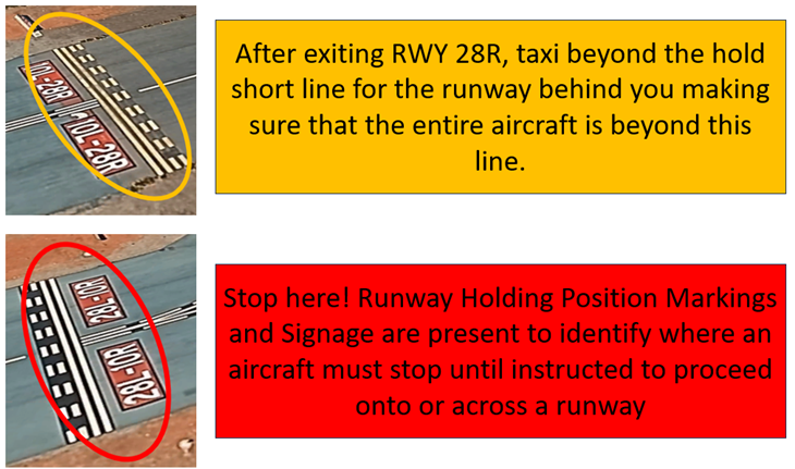
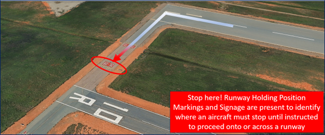
HS 1: Aircraft landing RWY 28R and exiting onto TWY M sometime cross RWY 28L without authorization.
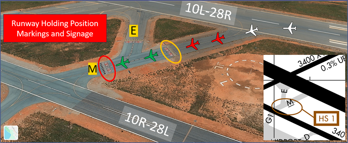
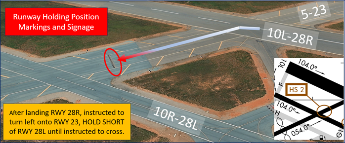
HS 2: Pilots exiting RWY 28R onto RWY 5/23 sometimes enter RWY 28L without authorization. Some pilots fail to hold short of the elevated RWY holding position sign on RWY 5/23 until issued further clearance to cross RWY 28L.

HS 3: Aircraft taxiing to RWY 28R approach end sometimes mistake TWY B for TWY A and cross RWY 28L without authorization.
- Pilots instructed to taxi RWY 28R via TWY H and TWY A sometimes mistakenly turn left early at TWY B and cross the RWY 28L Hold Line or the runway itself.
- For all of the above Hot Spot descriptions, pilots should review the taxi clearance before starting to taxi.
- Actively scanning to locate and identify RWY signs, markings, lighting and deferring all heads down activities until holding short at the appropriate location will help eliminate these errors. Remember, you must have a clearance to enter a runway whether it’s active or not.
- If you are unsure of your position or instructions, ask the tower.
Wrong Airport Landing Risk
See Arrival Alert Notices
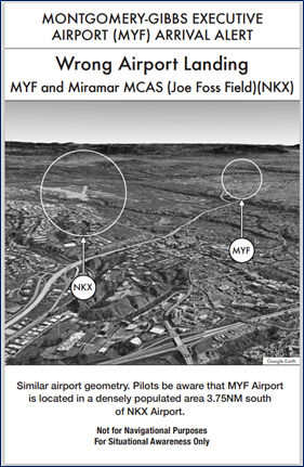
- During pre-flight planning, check the sectional chart for airports in close proximity and charted reporting points.
- Use the most precise navigational aids available such as GPS, localizers, or VOR radials to positively identify the airport.
- If you're talking to ATC and you're unsure, ask the controller.
- View the From the Flight Deck-Wrong Airport Landings video for more information and mitigation strategies.
Wrong Runway Landing Risk
- Closely spaced parallel RWYs and full length parallel TWYs increase the risk of wrong surface landings.
- At MYF, pilots cleared to land RWY 28L sometimes align with and land or attempt to land RWY 28R.
- Positive identification of the RWY should be a part of every pilot’s checklist.
- If available, back up all visual approaches with an instrument approach or GPS Waypoint to help ensure that you are lined up for the correct surface.
- Runway Markings are white. Markings on surfaces not used for takeoff/landing like Taxiway Markings, Chevrons, RWY Shoulder and RWY Turn-on Markings etc., are yellow.
Surface Movement Area Cautions
- Though not listed as a Hotspot, pilots that land RWY 28R and exit at TWY F with instructions to hold short of RWY 28L sometimes cross the RWY 28L hold line and/or the runway resulting in a runway incursion.
Pilot Readbacks
- Most pilot readback issues that generate hundreds of extra transmissions per day are as follows:
- No pilot read-back at all.
- Read backs without call sign.
- “Blind Transmissions” without call sign.
- Use of non-standard call signs.
- Pilots must read back runway assignments and complete hold short instructions with the callsign. The readback of the taxi route is good practice for students and for reinforcement but is not required by ATC.
- Incorrect: “(CALL-SIGN) HOLDING SHORT OF THE LEFT, (CALL-SIGN) HOLDING SHORT OF THE PARALLEL, (CALL-SIGN) HOLDING SHORT.”
- Correct: “(CALL-SIGN) HOLDING SHORT OF RUNWAY 28L.”
Ground Control (GC)
- When exiting RWY 28L or crossing RWY 28L on RWY 23, hold short of TWY H unless the aircraft is too large and would impede on RWY 28L.
- To relieve surface congestion, TWY H and RWY 23 are often used as taxi routes.
Takeoff/Departure
- Advise the MYF tower controller of your full call-sign, which runway you are holding short of and if you are IFR or VFR along with the direction of departure.
- RWY 28L run-up area holds two small aircraft.
- Use caution not to drift into the departure corridor of the parallel runway.
- MYF utilizes “Line Up and Wait” (LUAW) to instruct a pilot to taxi onto the departure RWY and hold position until cleared for takeoff. It is not an authorization for takeoff. For mitigation strategies, view the From the Flight Deck-Line Up and Wait video.
- Pilots requesting the Soledad Departure should review the Special Notice in Chart Supplement for specific instructions.
Arrival/Landing
- Mt. Soledad is a VFR reporting point located six miles west of Montgomery-Gibbs.
- For a “straight-in” RWYs 10L/R, remain north of Mt Soledad unless otherwise instructed by ATC.
- Aircraft from the north are typically altitude restricted until south of highway 52 and will be instructed to cross over MYF for a downwind or instructed to enter a downwind north of the airport.
- If a sequence or clearance has not been issued by the tower when passing abeam the runway threshold on the downwind, DO NOT assume you are number one and turn base leg. Ask the controller.
- DO NOT overshoot the final approach course. Chances are high there is another aircraft on final for the parallel +/- 500’ laterally.
Special Traffic/Additional Information
- Miramar (KNKX) military traffic often “spills out” of Class B airspace and into the north pattern of MYF.
- Be alert` to military jet aircraft in vicinity of MYF as well as 4.7 nm. northwest in the vicinity of the Mission Bay VORTAC.
- Operate transponders with altitude reporting mode and ADS–B (if equipped) enabled on all airport surfaces.
- Practice low approaches are prohibited 0730Z–1430Z.
- Be alert birds on and in the vicinity of the airport and coyote activity on runways and taxiways.