


St. Pete-Clearwater International Airport (PIE)
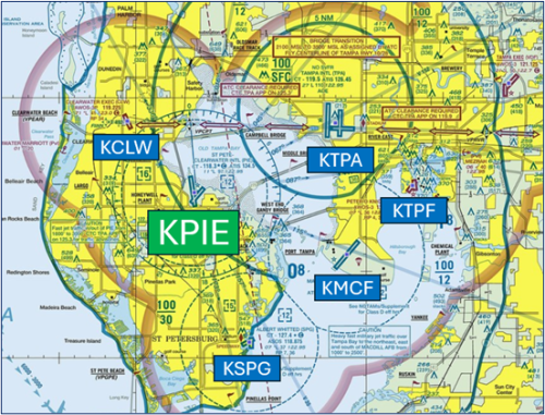
St Pete-Clearwater International Airport (PIE) is a multi-use airport located in Clearwater FL just north of St. Petersburg. The airport is situated nine miles southwest of Tampa International Airport (TPA). The traffic-mix ranges from civil and military aviation, flight training operations, air carriers, and a law-enforcement aviation unit. View a printable Pilot Handbook of the PIE information found on this Web page.
Know Before You Go
PIE ATCT Operates: 0600L to 2300L
Admin Office: Open 0700L to 1500L M-F
Business Phone: 727-539-6867
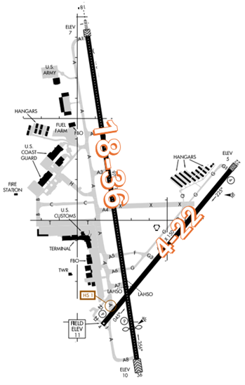
The airport configuration consists of RWY’s 4/22 and 18/36.
Note: Pilots are highly encouraged to review NOTAMS for ongoing airport construction.
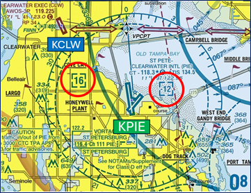
The airspace at PIE is Class D and underlies Tampa (TPA) Class B Airspace. The Class D ceiling at PIE changes depending upon its location beneath TPA Class B. (Refer to Sectional Chart.)
Cautions
- There are multiple airports in the vicinity of PIE. Use extreme caution when turning base outside of the PIE Class D airspace for RWY 18/36. Numerous VFR aircraft not in communications with ATC can be found in Class E and Class G areas northwest, southwest, and south of the PIE Class D airspace.
Hot Spots
HS 1: Maintain vigilance ramp/taxiway in close proximity to Hold Short at RWY 4/22.
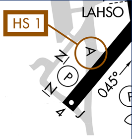
- Pilots taxied to RWY 4 via TWY A sometimes cross the holding position markings and enter the Runway Safety Area (RSA) or even cross the runway.
- Surface painted markings and signage are present to indicate where to hold short of the runway.
- Actively scanning to locate and identify RWY signs, markings, lighting and deferring all heads down activities until holding short at the appropriate location will help eliminate these errors.
- If you are unsure of your position or instructions, ask the tower. View the From the Flight Deck – Complex Airfield Geometry#2: Short Taxi Distance From Ramp or Apron To Runway for additional mitigation strategies.
Recently Opened TWY N
- The construction of TWY N provides pilots and controllers with additional options for exiting the southwest ramp as well as taxiing to RWY 4 and RWY 36.
- Pilots should review taxi clearances before starting to taxi to ensure that they are familiar with and are prepared for all Holding Position Markings that they may encounter along the taxi route.
Wrong Surface Intersection Takeoff Risks
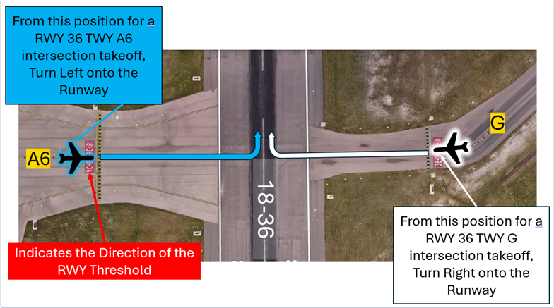
- At PIE or any airport, the risk exists where pilots may turn in the wrong direction during intersection takeoffs.
- Common intersection takeoffs occur on RWY 36 at TWYs A7, A6, and G.
- The example illustration below depicts the intersection of RWY 36 at TWY A6 and TWY G (from both sides of the runway). If approaching the runway from the opposite direction, the runway markings will have the numbers reversed.
- Extra Awareness is warranted for Hot Spot 1. If you miss your assigned departure intersection, you may end up crossing RWY 4 without proper clearance.
- Prior to entering and again when lining up on the runway, check your Magnetic Compass and your Horizontal Situation Indicator (HIS), if installed, to verify that you are pointed in the correct direction.
- View the From The Flight Deck – Wrong Direction Intersection Takeoffs video for additional mitigation strategies.
Wrong Surface Landing Risk
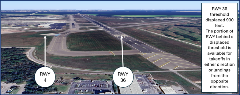
- A Wrong Surface Landing risk also exists due to the proximity of the approach ends of RWY 4 and RWY 36.
- When landing north on either RWY 36 or RWY 4, ensure alignment for the correct RWY especially when turning base to final.
- Expectation bias or lining up on the first runway that pilots see can lead to wrong surface landings.
- Pilots should verify that the heading on final aligns with the assigned landing runway. Loading an instrument approach/GPS Waypoint to the assigned runway will help pilots ensure they are lined up for the correct surface.
- RWY markings are white. Markings on surfaces not used for takeoff/landing like TWY markings, chevrons, RWY shoulder and RWY turn-on markings etc., are yellow.
- View the From the Flight Deck-Wrong Surface Landings video for additional mitigation strategies.
General
- Readback of specific instructions is required. This includes your call sign with the runway assignment, taxiway, and the hold-short instructions in the same transmission. Any readback that does not include these requirements will have to be repeated.
Ground Control (GC)
- Although the Terminal Ramp is uncontrolled, all aircraft must contact Ground Control for pushback clearance as you will be pushing back onto active taxiways.
Traffic Patterns
- When possible, pattern work will be conducted on RWY 4/22.
- Maintain a normal standard traffic pattern in accordance with the AIM and the FAA.
- Airplane Flying Handbook unless otherwise approved or directed by the controller.
- Request all early turns and non-standard traffic patterns from the controller.
- Pattern work aircraft can expect initial full-length departure from either RWY 18 or RWY 22 according to your location on the field or traffic volume. After departure, pattern work will be conducted on RWY 22.
Takeoff/Departure
- If you require a full-length departure, please advise Ground Control as soon as possible. Large aircraft (A320s, C130s, etc.) will be assigned RWY 36 full length.
- When RWY 4 and RWY 36 are in use, pattern work aircraft and aircraft transitioning through or landing at KSPG or KMCF can expect departure from RWY 4. All others expect RWY 36 as stated above.
- When PIE is departing to the south, expect full length departure from RWY 18. When both RWY 18 and RWY 22 are in use, expect full length departure from either runway depending upon your aircraft type and/or location on the field.
Arrival/Landing
- Tampa Approach will normally sequence all IFR aircraft to RWY 18/36. PIE ATCT may change this RWY assignment and/or sequence due to VFR traffic in the PIE class D, normally upon initial contact.
- Land and Hold Short (LAHSO) clearances may be issued to general aviation aircraft. Advise if you are unable to participate.
| LDG RWY | HOLD-SHORT POINT | AVBL LDG DIST |
|---|---|---|
| RWY 18 | 4/22 | 7557 |
| RWY 22 | 18/36 | 4514 |
Noise abatement
- IFR Noise abatement procedures (BAYPO RNAV DP, ENDED RNAV DP and ST. PETE DP) will be used for turbojet aircraft weighing more than 60,000 lbs. only. If unable RNAV departure, ATC will assign the ST. PETE departure procedure.
- All other IFR turbojet aircraft weighing 60,000 lbs. or less will be assigned the LLRGO RNAV departure procedure or radar vectors if unable RNAV departure.
- All other IFR departures and VFR aircraft requesting Class B Service will be assigned radar vectors.
- When PIE is conducting visual approaches to the south, all participating airlines can expect the RNAV Visual Approach RWY 18 for aircraft weighing more than 60,000 lbs. Non-participating turbojet aircraft weighing more than 60,000 lbs. can expect the North Bay Visual Approach RWY 18 during daytime hours or the VOR-B during nighttime hours.
Additional Information
- The airport’s geographic location leads to bird activity in the vicinity of the airport all year round. Bird activity can also be found approximately two miles south of the airport over the Pinellas County Solid Waste Disposal Complex.
- Noise sensitive area 5 miles north extending 1 mile east and west of Localizer to shoreline.
- Turbojets landing RWY 18 and Departing RWY 36 use published noise abatement procedures.
- Lights on highway north of airport may be mistaken for runway lights.
- Operate transponders with altitude reporting mode and ADS–B ( if equipped) enabled on all airport surfaces.