
Tulsa Riverside Airport (RVS)
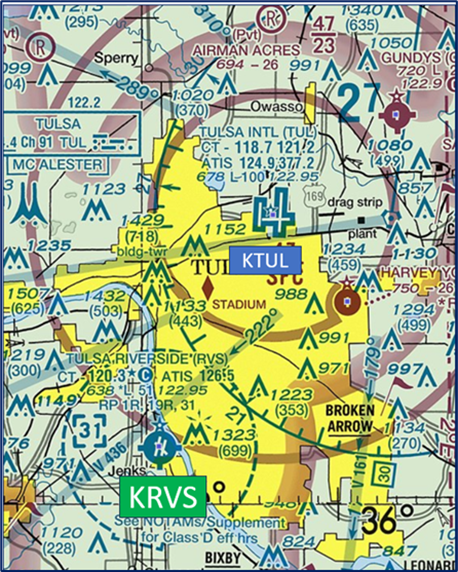
Tulsa Riverside Airport (RVS) is located just southwest of Tulsa, Oklahoma. The larger Tulsa International Airport (TUL) is located 10 miles northeast of the field on the opposite side of the city. This makes Riverside an attractive alternative for business and general aviation itinerant aircraft. It is also home to several flight schools and numerous hangered private aircraft. The mix of experience levels and aircraft performance contributes to the complexity of RVS. View a printable Pilot Handbook of the RVS information found on this Web page.
Know Before You Go
RVS ATCT Operates: 0700L-2200L
Administrative Office: Open 0800L-1600L M-F
Business Phone: 918-299-6355
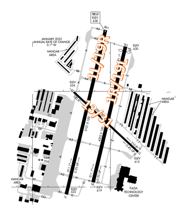
The RWY configuration consists of RWYs 1/19 L/R as well as 13/31.
The airspace at RVS is Class D and partially underlies Tulsa Class C airspace (Refer to Sectional Chart)
Wrong Surface Landing Risk
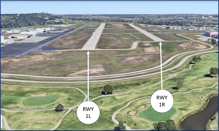
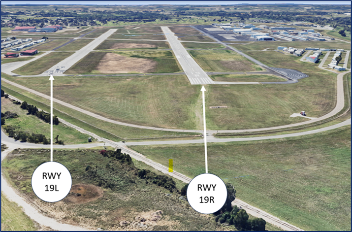
- Wrong Surface Landing risk exists due to closely spaced parallel runways with staggered thresholds.
- If available, back up all visual approaches with an instrument approach/GPS Waypoint to help ensure that you are lined up for the correct surface.
- Remember, RWY markings are white. Markings on surfaces not used for takeoff/landing like TWY markings, chevrons, RWY shoulder and RWY turn-on markings etc., are yellow.
- View the From the Flight Deck-Wrong Surface Landings video for additional mitigation strategies.
Recommended Departure Procedures
- In an effort to increase safety and provide the best possible service to the users of Tulsa Riverside Airport (RVS), Tulsa Riverside Tower has developed “Departure Procedures” for pilots departing the airport.
- Monitor the Automatic Terminal Information Service (ATIS) for RVS on frequency 126.5. This ATIS will provide instructions to contact Clearance Delivery (if operating) or Ground Control for frequency assignment, and an IFR clearance or VFR transponder code for basic radar services.
- Contact the appropriate controller to request an IFR clearance or state your direction of flight/destination for basic radar services.
- When you are ready to taxi, contact Ground Control for taxi instructions. Remain on Ground Control frequency while in run-up area.
- Advise Ground Control when ready for departure. Ground Control will provide sequence for departure and the appropriate Tower frequency (120.3 or 119.2).
- Monitor appropriate Tower frequency and contact when you are number one for departure. Respond if you are called upon. Advise Tower if departing IFR, otherwise provide direction of flight.
Ground Control (GC)
- If you are instructed to taxi “West of Alpha”, maneuver your aircraft west of the dashed taxiway edge marking to make room for aircraft taxiing in the opposite direction on TWY A.
- Portions of the airfield are classified as non-movement areas including Taxi-lanes BB, CC, DD, GG, FF, KK, TT and any ramp areas.
- Taxi-lanes and ramps are very difficult to see from the ATCT. Instructions in these areas are advisory in nature, based upon known traffic.
- GC is responsible for the run-up areas which are located adjacent to the approach end of each runway except for RWY 13 and RWY 1R.
Traffic Patterns
- When the ATCT is closed use right pattern for RWYs 1R, 19R, and 31.
- You will be expected to adjust your speed to follow your traffic.
- A common error for pilots flying in the pattern on the east side is to follow the river and roads instead of a standard pattern. By using ground landmarks, it is easy to cut out base traffic and overshoot final.
- When on the downwind for RWY 31, maintain traffic pattern altitude until abeam the approach end of the runway.
Takeoff/Departure
- Pilots departing VFR and are requesting radar service should state their destination or direction of flight. The controller will issue a beacon code, departure frequency, and an altitude restriction of “at or below 2500 feet (MSL)”.
- When departing, be sure to fly the ground track of the runway. Drifting even slightly left or right of course could create conflict with traffic departing the parallel runway.
- Pilots who request negative radar service will be given instructions on how to exit the Class D Airspace.
- Departure areas have been established to avoid potential conflicts with inbound aircraft. Pilots can expect a heading that coincides with the runway in use.
- If you are departing without radar services, the Tower will turn you on course when leaving the Class D Airspace.
- RVS utilizes “Line Up and Wait” (LUAW) to instruct a pilot to taxi onto the departure runway and hold position until cleared for takeoff. It is not authorization for takeoff.
- For mitigation strategies, view the From the Flight Deck-Line Up and Wait video.
Runway Exiting
- Pilots can expect to exit the runway without delay at the first available taxiway or as instructed by the controller.
- If Tower issues taxi instructions, they will either tell you to “remain this frequency” or “monitor ground to parking”.
- If told to monitor ground, switch to GC on 121.7 but do not call them. GC will reach out to you if they have any amendments to your taxi instructions from Tower.
- When landing either north or south flow, it is not uncommon for Tower to instruct an aircraft to exit onto RWY 13/31.
- If you exit between the parallel runways on RWY 13/31, be aware that there are no hold short lines for the other runways. You are still required to hold short of the parallel runway until advised.
- When landing RWY 13/31, listen to the controller for instructions to exit the runway (TWY Z, RWY 19L/1R, RWY 19R/1L, or TWY A) but DO NOT stop on the landing runway unless you have been instructed to do so.
- When landing RWY 31, remember that no taxiway connects to the far west end of the runway. The last available turnoff without having to back taxi on the runway is TWY A.
Arrival/Landing
- Tulsa Approach provides sequencing into RVS Class D Airspace. Approaches to RVS will depend on your flight plan, aircraft type, and the runway in use. Though the Class D extends up to 3100’ MSL, Riverside Tower only controls the airspace up to 2500’ MSL.
- Tower uses several VFR landmarks to provide spacing and sequencing to the landing runway. The following table below provides an overview of the most used geographical landmarks. If confused, ask the control tower for assistance.
| Landmark | Location | Description |
|---|---|---|
| I-44 | 3-mile final RWY 19R/L | 6 lane highway north of the airfield across the river that runs east to west |
| Turkey Mountain | 1.5 miles NNW KRVS | Tall hill on west side of river |
| 71st Street/The Bridge | 1-mile final RWY 19R/L | 4 lane highway across the river that runs east to west |
| Tulsa Hills | 2 miles NW KRVS | Large shopping center |
| Unit Corp Building | 1 mile WNW KRVS | 6 story L-shaped building |
| Swim School | 1/2 mile WSW KRVS | Blue and Yellow building adjacent to Golf Course |
| City of Faith | 2 miles E KRVS | 2 tall gold towers |
| The Bank | 2 miles SSE KRVS | Gold/copper colored dome in downtown Jenks |
| Golf Course | 1/2 mile final RWY 1L/R | South Lakes Golf Course in Jenks |
| (Creek) Turnpike | 1.5 miles S KRVS | 6 lane highway south of the airfield across the river that runs east to west |
| Powerplant/Red & White Stacks | 3 miles SE KRVS | 2 Red & White striped stacks on the river |
| White Tanks | 4 miles S KRVS | Cluster of large white oil tanks E of highway 75 |
| Turnpike Split | 5 miles W KRVS | I-44 and Creek Turnpike diverge as depicted on VFR sectional chart |
Special Traffic (Military / Commercial / Helicopter, etc.)
- VFR helicopters will be instructed by Approach Control to enter a boundary of the airport (East/West/North/South).
- After being switched to Tower, helicopters should advise where they are parking and expect a clearance or landing advisory shortly thereafter.
Additional Information
- RWY 19L threshold displaced.
- Noise abatement: No turns on departure prior to 1500’ MSL.
- NE, NW, and SW ramps, portions of Taxi-lanes CC, DD, and GG not visible from the TWR.