
Treasure Coast International Airport (FPR)
Treasure Coast International Airport (PR) is a primarily general and corporate aviation airport, located between the cities of Vero Beach, FL. to the north and Fort Pierce, FL. to the south. It is a popular exit and entry point for general aviation aircraft visiting the Bahamas. VFR flight following in the airspace surrounding Treasure Coast International is provided by Palm Beach Approach Control and is highly recommended. The FPR traffic mix consists of everything from primary training aircraft up to and including large cabin class jets. View a printable Pilot Handbook of the FPR information found on this Web page.
Know Before You Go
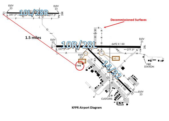
The airspace at FPR is Class D. (Refer to Sectional Chart)
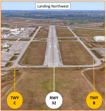
The airport configuration consists of parallel RWY’s 10L/28R and 10R/28L along with non-intersecting RWY 14/32.
FPR Tower Hours of Operation 0700L-2100L
Administrative Office Open 0700L to 1530L M-F
Business Phone 772-465-0761
Below find various FPR-specific information and things to be aware of, as well as general information to inform your preflight planning. This will be reviewed quarterly and updated as needed. This information is to supplement the From the Flight Deck Videos that are produced by the FAA Runway Safety Group. Here you will also find information provided by the local air traffic controllers at the airport where you intend to fly. The information is subject to change. Not for navigation or legal* pre-flight action. Always refer to official pre-flight materials such as, but not limited to, NOTAMs, airport diagrams, VFR charts and airport construction notices for the latest airport-specific details.
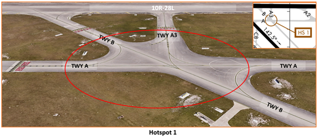
Hot Spots
- HS 1 Maintain vigilance confusing intersection.
- This intersection is a large area of concrete that can be confusing to the itinerant pilot.
- TWY markings and elevated signage are present to help pilots navigate this area.
- If you are ever unsure of your position or instructions, ask the TWR.
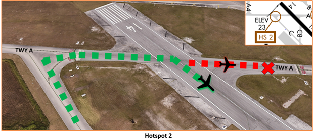
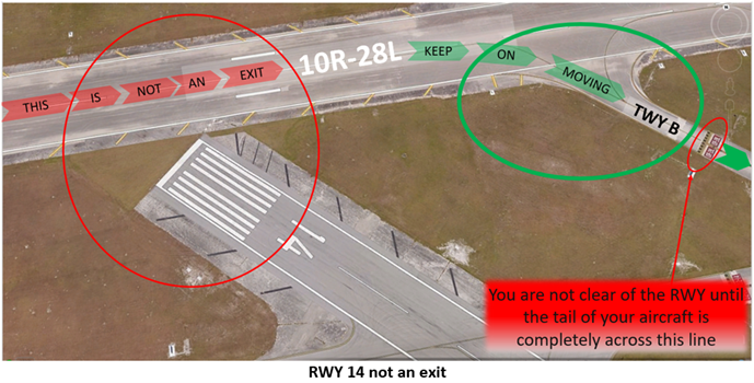
- HS 2 Confusing intersection; pilots have used TWY A as a RWY.
- On multiple occasions, pilots having been issued a take-off clearance on RWY 14 have failed to turn onto the RWY and have departed or attempted to depart on TWY A.
- Prior to entering the RWY and again when lining up on the RWY, check your Magnetic Compass and, your Horizontal Situation Indicator (HSI), if installed, to verify that you are pointed in the correct direction.
- RWY Markings are white. Markings on surfaces not used for Takeoff/Landing like TWY Markings, Chevrons, RWY Shoulder and RWY Turn-on Markings etc., are yellow.
Wrong Surface Landing Risk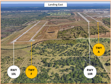
- Wrong Surface Landing risks exists with parallel and offset RWYs with staggered thresholds.
- Some confusion has occurred with pilots cleared to land on RWY10L/R. These RWYs are greater than 2500’ apart.
- RWY 10R is more than one-third longer and is twice as wide as RWY 10L.
- RWY 10R has an ILS Approach, Runway End Identifier Lights (REILS), and precision approach markings on the RWY.
- The risk of landing or taking off on a TWY exists whenever a TWY runs full-length to a RWY.
- There are multiple full-length parallel TWYs at FPR.
- Loading an instrument approach to the assigned RWY will help pilots ensure they are lined up for the proper surface.
- RWY Markings are white. Markings on surfaces not used for Takeoff/Landing
- like Taxiway Markings, Chevrons, RWY Shoulder and RWY Turn-on Markings etc., are yellow.
- If you are ever in doubt of your instructions or your position, ask the TWR.
Surface Risk – Movement Area Cautions
- When rolling out on RWY 10R and approaching where the RWY 14 threshold used to connect, pilots occasionally mistake this area for TWY B and may attempt to exit.
- This additional delay could impact the trailing arrival and possibly contribute to a go-around.
- Reviewing the airport diagram prior to arrival may help pilots avoid this situation.
General
- FPR is a student-rich environment. Be alert on frequency, and use caution not to step on other’s transmissions or readbacks.
- IFR clearances are issued on ground control frequency.
Traffic Patterns
- The majority of pattern work occurs on RWY 10L.
- One of the biggest concerns we have here at FPR, is traffic on opposing base legs to the parallel RWYs.
- Do not overfly the turn to final.
- When operating on RWY 14, pilots tend to use the Fort Pierce Inlet as a visual reference point for their upwind. This does not align with the upwind heading and leads to additional problems with RWY 14 traffic patterns.
- We have similarly seen pilots using the ocean shoreline as a guide for their downwind for RWY 14. Aircraft #1 in the pattern could be following the shoreline, while Aircraft #2 is flying a left pattern using appropriate headings.
- In both of these instances, flying a standard traffic pattern with adjustments for wind drift is the expectation.
- Pilots failing to fly a uniform traffic pattern may introduce confusion when TWR issues traffic and sequences traffic.
Ground Control
- When operating on RWY 32, be advised that there is no run-up area at or near the approach end of the RWY.
- Please complete your pre-flight run-up in the ramp, so as not to block others who are ready for departure.
Runway Crossings
- Never cross a RWY unless you’ve been specifically instructed to cross.
- If you are uncertain of your clearance/instruction, ask the TWR.
- Read back all RWY crossing and hold short instructions including your callsign.
Arrivals/Departures
- Palm Beach Approach Control provides IFR separation services to VFR aircraft conducting practice instrument approaches when the ATCT is open.
- Review the Letter to Airmen (LTA) found in NOTAMS for more details.
Weather
- If you are not familiar with Special VFR flying requirements, we would suggest brushing up on them… as weather here at KFPR will change rapidly.
Avoidance Areas
- Many student pilots use the airspace 5-10 miles west of FPR as a training area. When inbound from the west, use caution for VFR aircraft that may or may not be on frequency, and will likely be flying through final.
- If you are flying in the area, try not to loiter on the extended final approach course for RWYs 10L/R.
- Actively listen on frequency and be aware of what aircraft might be flying an instrument approach in your area.
- Also use caution conducting practice maneuvers like steep turns and stalls out to the west of FPR. Palm Beach Approach may be vectoring jet arrival traffic for RWY 10R.
Special Traffic (Military / Commercial / Helicopter, etc.)
- Helicopter arrivals and departures state your destination ramp/parking or your location on the airport.
- If not stated, TWR may assume you want to land/depart on a movement area.
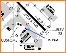
- If you are near the FBO, we will typically issue you clearance to/from TWY C abeam the ramp that is in front of the Tiki FBO.
Additional Information
- RWY 10L/28R is a VFR Training RWY.
- Numerous flocks of birds and wildlife on and in the vicinity of the airport.
- Extensive Flight Training on and within 20 miles of the airport Below 6000’.
- VFR Training aircraft outside of Class D airspace transmit intended activity on 123.30.