
Fort Smith Regional Airport (FSM)
Fort Smith Regional Airport (FSM) is a joint civil-military airport located in west central Arkansas and 3 miles southeast of the center of the city of Fort Smith, Arkansas. The traffic mix includes regional passenger air carrier service, transient and local general aviation, and air taxi commercial operations. It is also home to the Arkansas Air National Guard’s 188th Wing which features the MQ-9 Reaper, a remotely controlled unmanned aerial vehicle (UAV). View a printable Pilot Handbook of the FSM information found on this Web page.
Know Before You Go
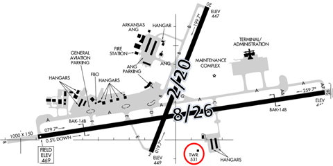
There are two intersecting RWYs designated RWY 8/26 and 2/20. RWY 8/26 is the primary instrument RWY with precision RWY markings. RWY 20 and 26 both have adjoining parallel TWYs. The Air National Guard Facility and most of the airport facilities lie to the north of RWY 8/26.
The airspace at FSM is Class D and underlies the Fort Smith Traffic Radar Service Area (TRSA). (See Sectional Chart.)
FSM TWR Hours of Operation: 0530 to 2300L.
Administrative Office: Open 0730L to 1600L - M through F
Business Phone: 469-649-2400.
Hot Spots
- There are no hot spots at FSM.
Wrong Surface Intersection Takeoff
- At FSM, or at any facility where intersection take offs are authorized, there is the risk that pilots will turn in the wrong direction when turning onto the RWY.
- It is critical to verify the correct direction prior to lining up on the RWY.
- Always check your Magnetic Compass and, (if installed), your Horizontal Situation Indicator (HSI) to verify that you are pointed in the correct direction.
Note: For complete illustrations and descriptions of airport markings and signs refer to the Aeronautical Information Manual - Chapter 2.
Wrong Surface TWY Landings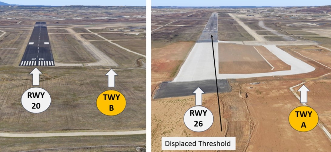
- The risk of landing on a TWY exists whenever there are parallel TWYs adjacent to the RWYs.
- Note: RWY Markings are White. Markings on Surfaces not used for Takeoff and Landing are Yellow.
Additional Cautions
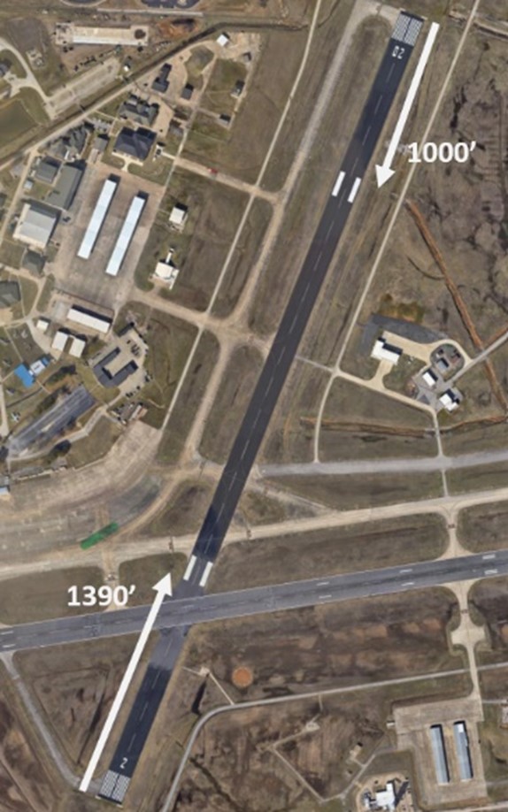
- RWY 2 Aiming Point Marking is located 1390’ from the RWY threshold.
- Note: At most airports you will find the RWY Aiming Point 1000’ from the RWY threshold.
Ground Control
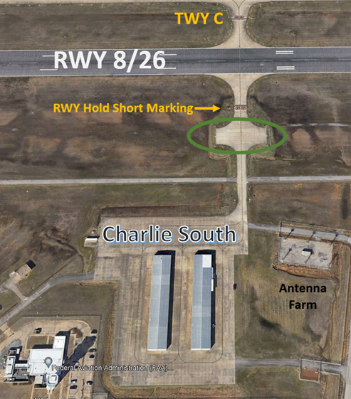 “Charlie South”:
- The taxilane south of the intersection of TWY C and RWY 8/26 leads to a ramp area commonly referred to as "Charlie South".
- TWY C does not continue south of RWY 8/26.
- Charlie South is a non-movement area.
- Located at Charlie South are self-serve fuel pumps and general aviation hangars.
- This area is adjacent to the FAA Air Traffic Control Tower (ATCT).
- When Outbound from Charlie South only - this does not apply to all departures:
- There is no non-movement area boundary.
- You will see the enhanced TWY centerline and RWY 8/26 Holding Short Markings. Do not cross the solid double line without clearance from TWR.
- There is space just south of the RWY Holding Short marking to complete your run-up checks.
- Please complete your run-up check prior to calling for taxi.
- When requesting taxi from Charlie South, please utilize clearance delivery frequency 133.85 due to bleed-over. This area is adjacent to the antenna farm and 121.9 will set off TWR’s Radar Frequency (120.9) and Guard (121.5).
- Ground and clearance delivery frequencies are combined and worked by the same controller.
- Please state your destination airport on initial call-up to ground/clearance delivery.
- If you do not wish to receive radar services on departure, please state "negative services".
- Expect to receive a squawk code to depart the FSM delta even if you are not receiving radar services.
Takeoff/Departure
- Current runway construction prohibits IFR departures on RWY 8.
- In VFR conditions, you may depart VFR and pick up your IFR clearance with Razorback Departure.
- If RWY 8 is active and you would like to depart VFR, please inform ground/clearance delivery.
Avoidance Areas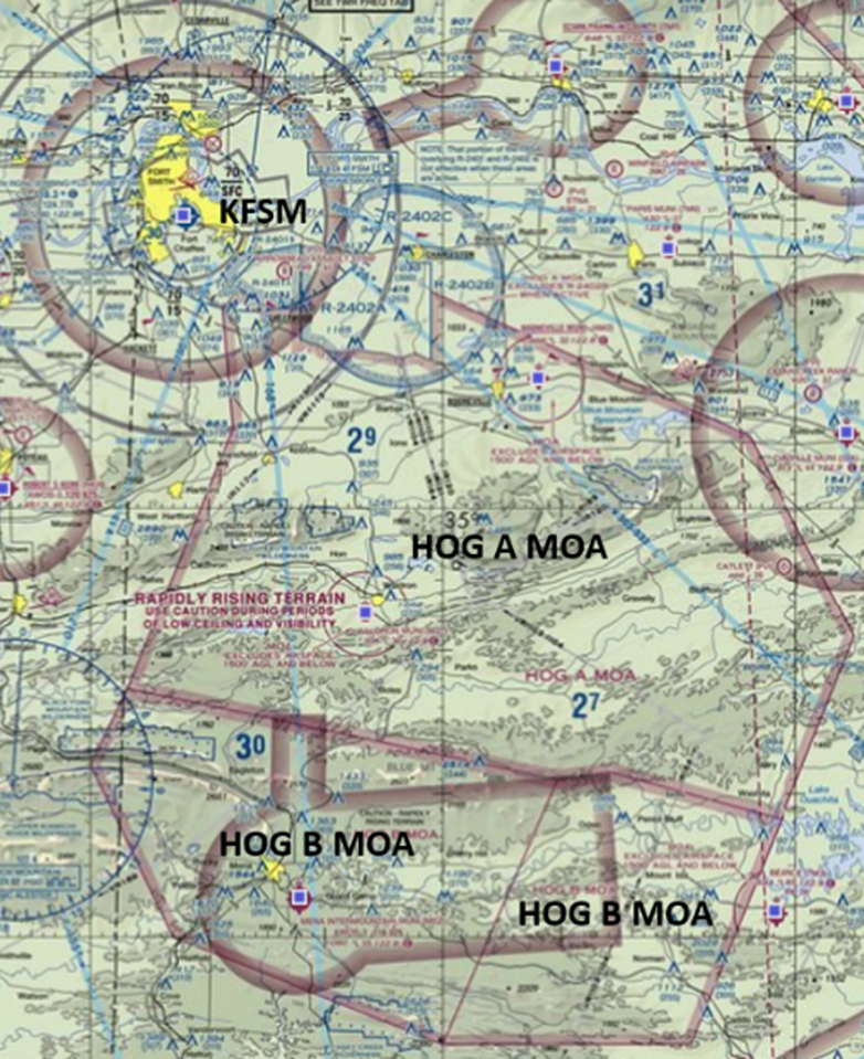
- Caution for rapidly rising terrain south of FSM. See sectional chart.
Special Traffic (Military / Commercial / Helicopter, etc.)
- Use caution for Restricted Airspace and the HOG MOA complex just southeast of the airport.
- These SUA's are frequently activated to different altitudes throughout the day.
- Listen to the FSM ATIS or contact Razorback Approach on 120.9 for the latest status of the nearby SUA's.
Special Note: The Arkansas ANG flies the drones remotely. None are located at FSM so they will not be in the traffic pattern.