Greenville Downtown Airport (GMU)
Greenville Downtown Airport (GMU) is a medium-sized general aviation airport located on the eastern edge of the city of Greenville, South Carolina. It primarily serves the general and business aviation community, air taxi traffic and a local Medivac network. This, combined with seven flight schools located on the airport, makes for a wide range of pilot experience and aircraft performance. View a printable Pilot Handbook of the GMU information found on this Web page.
Know Before You Go
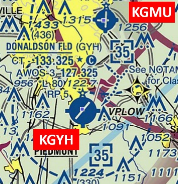
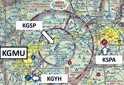
The airport is six miles southwest of the larger Greenville Spartanburg International Airport (GSP) and five miles north of the Donaldson Field Airport (GYH). Pilots have confused these airports primarily when operations are in a north configuration.
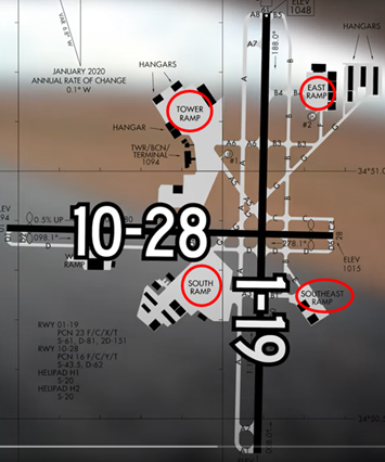
The airport configuration consists of two intersecting runways designated RWY 1/19 and RWY 10/28. A complex taxiway system provides access to all businesses on the field, including the FBO and ramp areas which are in all four quadrants of the airport. There is a high number of vehicular traffic, including slower aircraft under tow and golf carts.
GMU Tower Hours of Operation: 0700L-2200L
Administrative Office: Open 0700L to 1500L - M through F
Business Phone: 864-271-2033
The airspace at GMU is Class D and underlies Greer Class C airspace. (Refer to Sectional Chart.)
Below find various GMU-specific information and things to be aware of, as well as general information to inform your preflight planning. This will be reviewed quarterly and updated as needed. This information is to supplement the From the Flight Deck Videos that are produced by the FAA Runway Safety Group. Here you will also find information provided by the local air traffic controllers at the airport where you intend to fly. The information is subject to change. Not for navigation or legal* pre-flight action. Always refer to official pre-flight materials such as, but not limited to, NOTAMs, airport diagrams, VFR charts and airport construction notices for the latest airport-specific details.
Hot Spots 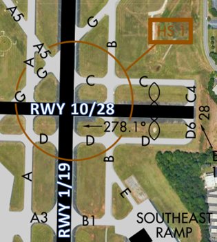
- HS 1 Maintain vigilance complex RWY and TWY Intersection.
- Multiple TWYs converge at this Hot Spot and a RWY intersection adds to the complexity.
- It is necessary that the pilot follows controller instructions.
- Maintain outside vigilance and utilize the TWY and RWY signs and markings to adhere to your clearance.
- There have been several RWY incursions at this intersection.
- Always ask the controller if you are in doubt.
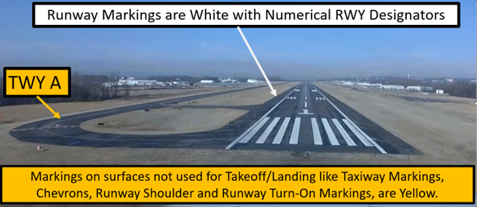
Wrong Surface TWY Landing
- The risk of landing on a TWY exists at airports with TWYs that parallel the adjoining RWY.
Landing
- RWY 10/28 thresholds are displaced.
- When exiting the RWY, do not stop short or not completely across the Hold Short Line. You are not clear of the RWY until every part of your aircraft is across the Hold Short Line. Not clearing the RWY may cause following aircraft to go-around.
Surface Risk – Movement Area Cautions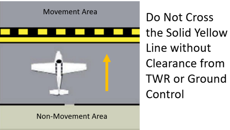
- You may receive instructions to cross multiple runways in a single clearance from TWR or Ground Control. This will only occur when the crossings are close to each other and should be obvious on the airport diagram. This procedure is designed to reduce verbiage and frequency congestion. Always remember to ask the TWR if you are unsure of your clearance.
- GMU has numerous non-movement areas.
- Movement areas are controlled.
- All pedestrians, vehicles, or aircraft must obtain clearance from TWR or Ground Control to enter all movement areas.
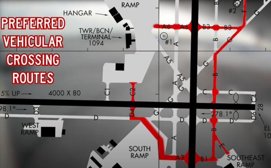
- GMU has a very high-volume of vehicle operations. 5 ramp areas located in all quadrants of the airport have led to the establishment of preferred vehicular crossing routes. These are designed to provide the common and most direct routes for vehicular traffic accessing different locations on the airport. Aircraft have priority over vehicle traffic but knowing where you will likely encounter such traffic is helpful.
Additional Cautions
- Aircraft operating south thru east of the airport should be alert for jet and conventional traffic descending on the GSP localizer course.
- Aircraft inbound from the SSW or on ILS RWY 1 approach, be alert for traffic 4.5 miles south operating in the Donaldson Field Airport (GYH) traffic pattern at 1800´ or below.
- No aircraft are permitted on TWY C or TWY D when an aircraft greater than 12,500 lbs. is operating on RWY 10/28.
- RWY 10/28 restricted to small aircraft less than 12,500 lbs., when an aircraft is operating on TWY C or TWY D.
- Noise abatement procedures in effect, contact airport manager 864–242–4777.
- Engineered Material Arresting System (EMAS) is installed at the departure end of
- RWY 1. This system is designed to slow down or stop an aircraft in the event of a RWY over-run. Plans call for installation at the departure end of RWY 19 in the future. Use caution when operating near the RWY end to avoid entering the EMAS surface in non-emergency situations. This can cause damage to its surface.
General
- Near GMU, there are three public-use airports (GSP, GYH and SPA). These airports have overlapping airspace.
- Pilots flying into this area for the first time are encouraged to familiarize themselves prior to visiting.
Traffic Patterns
- Pattern altitude 1800’ MSL/800’ AGL.
- Large aircraft pattern altitude 2000’ MSL/1000’ AGL
Takeoff/Departure 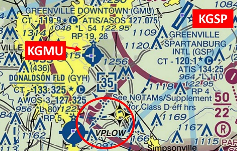
- VFR departures must remain clear of GSP Approach Control Airspace.
- When GSP is on a north operation, (using RWY 4), all VFR departures wishing for an on course heading of 010° to 190° are required to depart via VFR waypoint VPLOW (GMU 165/4.5). See illustration below or accept VFR Flight Following with a VFR squawk.
Arrival/Landing
- Arrivals must be alert for VFR pattern aircraft at the GYH airport approximately 5 miles south of GMU.
- GMU arrivals should not descend below 2300 MSL while over-flying GYH Class D airspace