
Daniel K. Inouye International Airport (HNL)
Daniel K Inouye International Airport (HNL), located in Honolulu, HI, is a busy airport, averaging over 700 operations daily. The traffic mix is diverse with commercial passenger air carrier, cargo, general aviation, helicopter, and joint military operations with Hickam Air Force Base (HIK) and the Hawaii Air National Guard (ANG). HNL has both GA and helicopter flight schools. View a printable Pilot Handbook of the HNL information found on this Web page.
Attention: This video details emphasizes the hold short markings between parallel runways 4L/R-22R/L that became effective January 26, 2018, as well as other runway safety best practices.
Know Before You Go
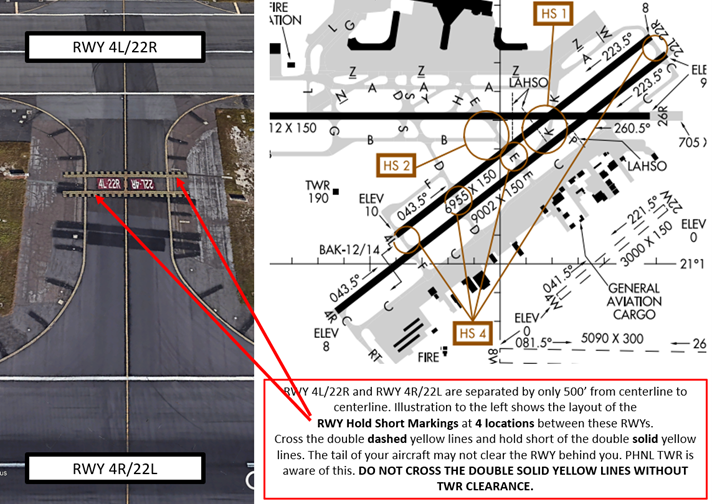
HNL has two sets of parallel RWYs. RWY 8L/26R and RWY 8R/26L are parallel, offset and separated by over 6500’. RWY 4L/22R and RWY 4R/22L are closely spaced, parallel, offset and separated by only 500’ from centerline to centerline.
RWY 4L/22R and RWY 4R/22L intersect RWY 8L/26R at an angle near the east end of the airport. In addition to the on-land RWYs, HNL has two Waterways designated 4W/22W and 8W/26W. (Blue ovals in diagram below.)
TWYs provide access to facilities located at mid-field and on the north side of the airport. TWY R parallels the full length of RWY 8/26L. See airfield diagram below.

HNL TWR Hours of Operation: Continuous – 24/7
Administrative Office Open: 0700L to 1600L - M through F
Business Phone: 808-840-6102
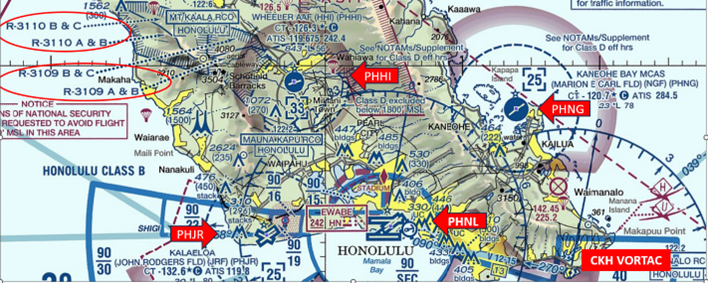
The airspace at HNL is Class B. (Refer to Sectional Chart.)
Below find various HNL-specific information and things to be aware of, as well as general information to inform your preflight planning. This will be reviewed quarterly and updated as needed. This information is to supplement the From the Flight Deck Videos that are produced by the FAA Runway Safety Group. Here you will also find information provided by the local air traffic controllers at the airport where you intend to fly. The information is subject to change. Not for navigation or legal* pre-flight action. Always refer to official pre-flight materials such as, but not limited to, NOTAMs, airport diagrams, VFR charts and airport construction notices for the latest airport-specific details.
Hot Spots
HS 1: Aircraft landing RWY 4R and exiting left onto TWY K sometimes fail to hold short of RWY 4L/22R and RWY 8L/26R. When holding short, ATC is aware the aircraft tail is encroaching the landing RWY.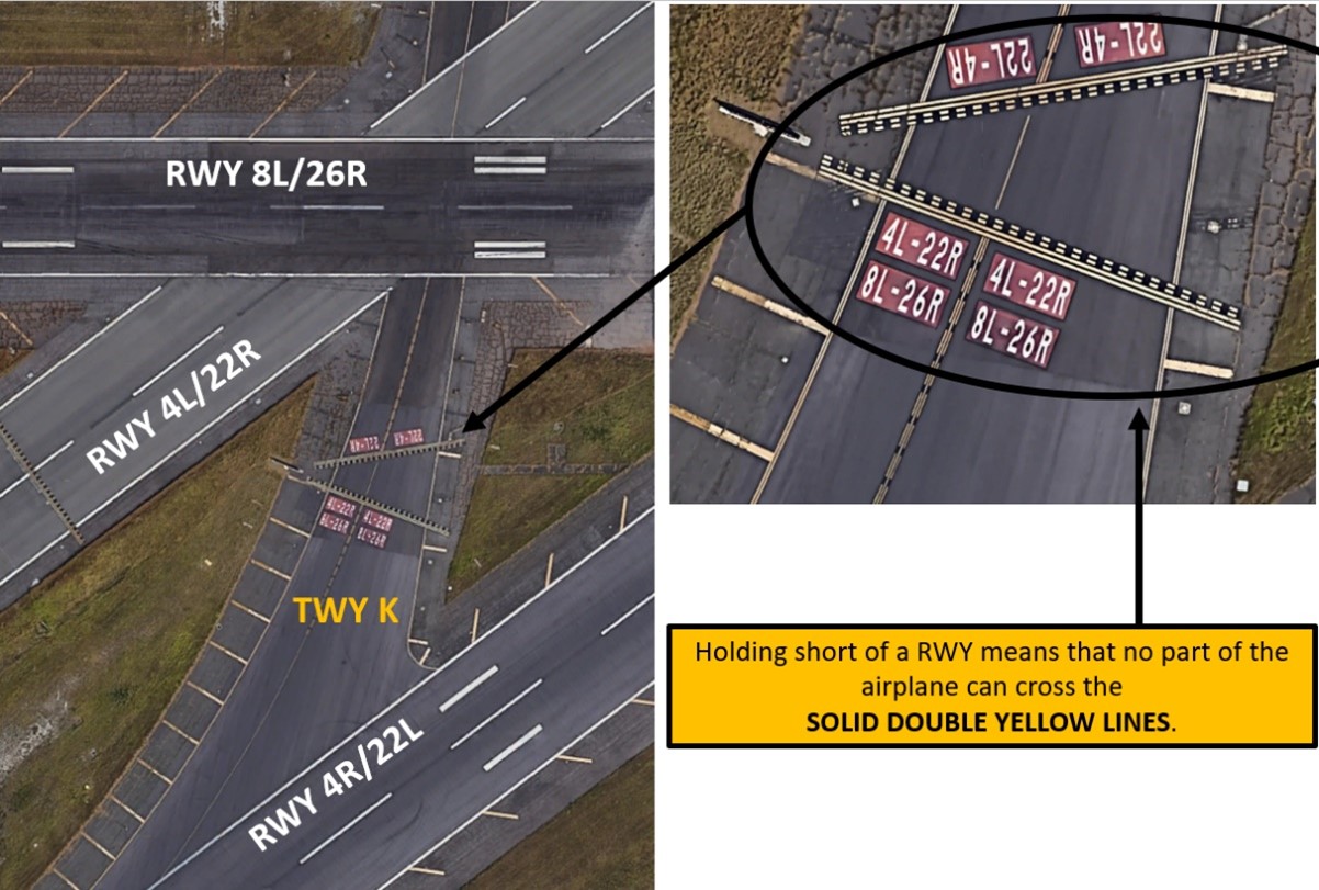
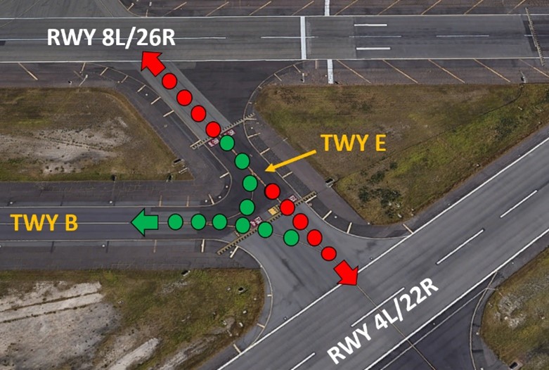
HS-2: Aircraft proceeding north or south on TWY E and instructed to turn onto TWY B sometimes miss the turn onto TWY B and enter RWY 8L/26R or 4L/22R without clearance.
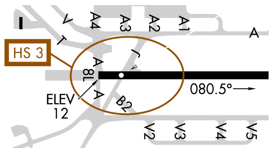
HS 3: TWY V, TWY T, TWY A and TWY J in close proximity to RWY 8L.
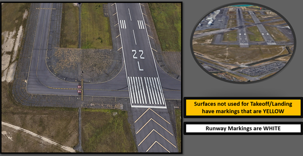
HS 4: Minimal distance between RWY hold short lines between RWY 4L/22R and RWY 4R/22L. (See below.)
Wrong Surface Takeoff
- Wrong Surface Takeoff risk exists with parallel and offset RWYs. Ensure you are departing on the correct RWY (Left or Right).
- Always check the Magnetic Compass / Horizontal Situation Indicator (HIS) to confirm departure in the correct direction.
Wrong Surface Landing
See Arrival Alert Notices
- Wrong Surface Landing risk exists with parallel and offset RWYs. Ensure that you are landing on the correct RWY (Left or Right).
- Due to TWR location, controllers are unable to determine whether aircraft are on correct final approach to RWYs 4L,4R, 22L and 22R.
Wrong Surface TWY Landing
- Aircraft lined up on 3 different taxiways but were sent around by TWR.
- Be alert to TWYs which parallel the full length of a RWY, like TWY R in HNL.
Surface Risk – Movement Area Cautions
- Due to non-visibility, TWR is unable to determine if the following areas are clear of obstructions and/or traffic (See airfield diagram):
- Portions of TWY J between TWY B and RWY 8R.
- Portions of inter-island aircraft parking ramp.
Additional Cautions
- RWY 26L and 26R arrivals: Remain at traffic pattern altitude as long as possible before beginning descent for landing.
- No special VFR at HNL.
- Recreational boating activities on and in vicinity of waterways.
- Remain at least 1 mile offshore of Waikiki, Diamond Head, Koko Head, & Ewa beaches.
- Bird strike hazard exists on all RWYs.
General
- Due to the complex layout of the runways at HNL, TWR Controllers have a large amount of additional phraseology that must be issued. Therefore, we ask that instructors assist Air Traffic Control (ATC) mitigate frequency congestion by taking over transmissions from student pilots that are having difficulty reading back control instructions easily and accurately until they can make transmissions in a timely manner.
- If you are a student solo flight, the Honolulu Control Facility (HCF) requests you state “student solo” with every frequency you contact.
- Read back all control instructions and hold short instructions with your callsign.
- Hold short read backs by pilots must include the phraseology “hold short of…”.
Traffic Patterns
- It is very important to be familiar with and follow all published arrivals/controller instructions. Due to the layout of the runways, there is little room for deviation.
- If your arrival flight path routes you over RWY 8L, be sure to overfly the TWY L/G intersection [which is located midfield, north of RWY 8L/26R, and west of the passenger terminal].
- If TWR instructs you to extend downwind to RWY 4R/4L, that automatically cancels the TWY R restriction and allows you to fly your downwind past RWY 8R.
Ground Control
- To alleviate frequency congestion, please state your current position when contacting Ground for taxi. Read back control instructions with your call sign.
- If not already instructed to do so, when holding short of an active runway, you should automatically monitor the TWR frequency.
- When instructed to “monitor TWR”, the pilot should change to TWR frequency, but do not advise TWR they are ready for departure. TWR will reach out to you when they are able to depart you from HNL.
- If you’re taxiing from the south ramp (TWY C) for a RWY 8R departure, be aware that the hold short for the RWY 4R approach is on TWY R near the HNL VORTAC.
Runway Crossings
- Read back all control instructions with your call sign.
- Be aware of the hold bars between RWY 4R/4L and on the TWY K overlap. Hold short of the first hold bar.
- Assist controllers by advising if you’re unsure of a route or clearance. ATC would rather issue more detailed instructions than have a pilot confused and result in a Pilot Deviation or Runway Incursion.
Takeoff/Departure
- If not already instructed to do so, automatically monitor the TWR frequency when holding short of an active runway.
- Begin takeoff roll in a timely manner, if unable, advise TWR.
- Request additional wake turbulence hold prior to entering the runway.
- Familiarize yourself with all coded Visual Flight Rules (VFR) departures as you may possibly be asked to fly a different VFR departure route by TWR.
- Many of the routes follow major roads which intersect and parallel. Be sure to familiarize yourself with Moanalua Freeway/H1 Freeway/Nimitz Highway prior to departing.
Arrival/Landing
- Land and Hold Short Operations (LAHSO) are in effect at HNL. If unable LAHSO, advise approach control on initial contact or ASAP.
- When landing RWY 4R/22L, do not exit at TWY F unless approved by TWR. RWY 4L departure traffic may be holding short to cross RWY 4R/22L at TWY F.
- Due to a new clarification of ATC rules, arrival aircraft that have completed landing roll may be instructed to hold short of the crossing runway to allow a departure or arrival to utilize the crossing runway. TWR asks that pilots read back hold short instructions or state “unable”.
Weather
- If requesting the Shoreline departure due to turbulence or cloud coverage over the freeway, advise Clearance Delivery of the reason.
- When operating in Class B Airspace or receiving ATC services from Approach Control, advise if an altitude deviation is necessary due to weather.
Avoidance Areas
- Do not enter, depart, or fly through Class B Airspace without an ATC clearance.
- We suggest you do not conduct flight training near the inbound jet routes starting from BAMBO or BOOKE intersections.
- [BAMBO: CKH 039/014]
- [BOOKE: LIH 110/058]
- Be aware of Kalaeloa (John Rodgers Field) (JRF)(PHJR), Wheeler AAF (HHI)(PHHI), Kaneohe Bay MCAS (NGF)(HNG) airspace and Restricted Areas R3109 and R3110.
Special Traffic
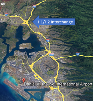
- Be aware of the heavy volume of helicopter traffic (tour and military). The H1/H2 interchange as well as CKH VORTAC are areas of high VFR traffic congestion.
- HNL is a unique airport which services military, commercial, GA including numerous flight schools, and tour helicopters. Because of this combination of different aircraft and a unique airport layout, it is important that users remain vigilant when operating at HNL.
Additional Information
- Tours of the Honolulu Control Facility (HCF) are available and encouraged to help the flying public gain a better understanding of what a controller’s job entails and to answer any questions you may have.
- [The Hawaii Air National Guard (HIANG) hosts the Sentry Aloha Exercise. This is a realistic combat training exercise involving the Air National Guard, U.S. Air Force, and other DOD services. During this time, HNL will experience an increase in HIANG and Sentry Aloha military aircraft.]