
Niagara Falls International Airport (IAG)
Niagara Falls International Airport (IAG) is a joint civil-military airfield, located approximately 6 NM east of the world-famous Niagara Falls and 16 NM northwest of the Buffalo International Airport (BUF) at Buffalo, NY. Primarily serving both local and transient general aviation, IAG also supports commercial and air taxi operations, and flight training. It is home to the Air Force Reserve Command’s 914th Air Refueling Wing which flies the KC-135R Stratotanker. Also located at IAG is the 107th Attack Wing of the New York Air National Guard which flies the unmanned MQ-9 Reaper aircraft. This varied mix of traffic and flight operations makes for a wide range of pilot experience and aircraft performance. View a printable Pilot Handbook of the IAG information found on this Web page.
Know Before You Go
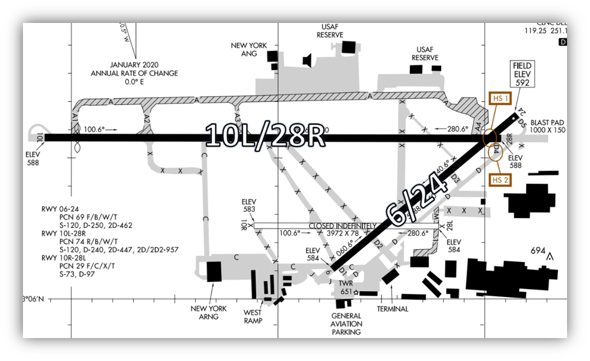
The airport configuration consists of two runways (RWYs) designated RWY 10L/28R and RWY 6/24. These RWYs intersect at the northeast end of the field.
A complex taxiway (TWY) system provides access to all businesses on the field, including the FBO and ramp areas located in the south/southeast quadrant of the airport. The military is located on the north and south sides of the airport.
IAG Tower
Hours of Operation: 0700L-2300L
Administrative Office:
Open 0800L to 1600L - M through F
Business Phone: 716-297-1310-Opt. 1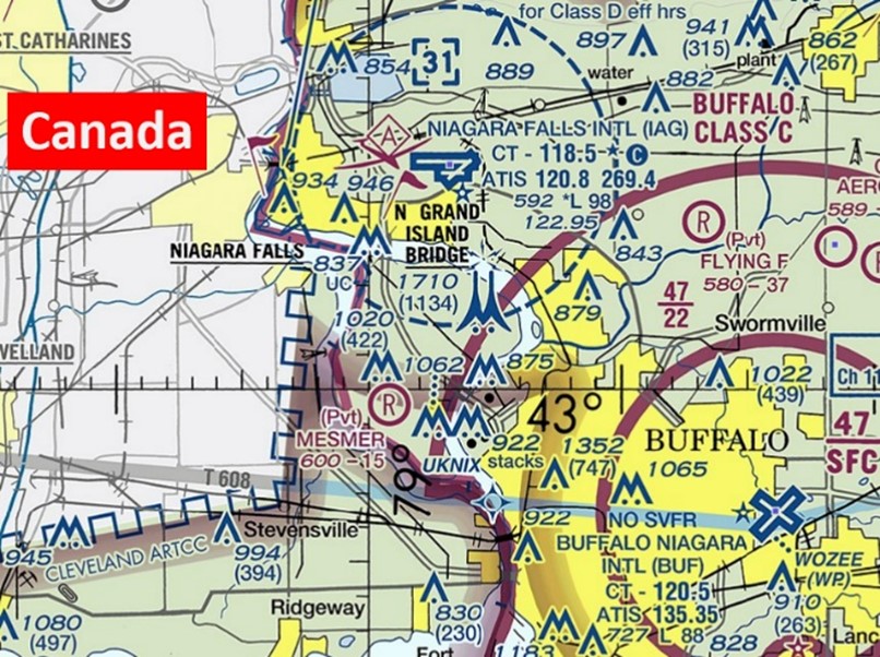
The airspace at IAG is Class D, and partially underlies Buffalo Class C airspace. (Refer to sectional chart.)
Below find various IAG-specific information and things to be aware of, as well as general information to inform your preflight planning. This will be reviewed quarterly and updated as needed. This information is to supplement the From the Flight Deck Videos that are produced by the FAA Runway Safety Group. Here you will also find information provided by the local air traffic controllers at the airport where you intend to fly. The information is subject to change. Not for navigation or legal* pre-flight action. Always refer to official pre-flight materials such as, but not limited to, NOTAMs, airport diagrams, VFR charts and airport construction notices for the latest airport-specific details.
Hot Spots
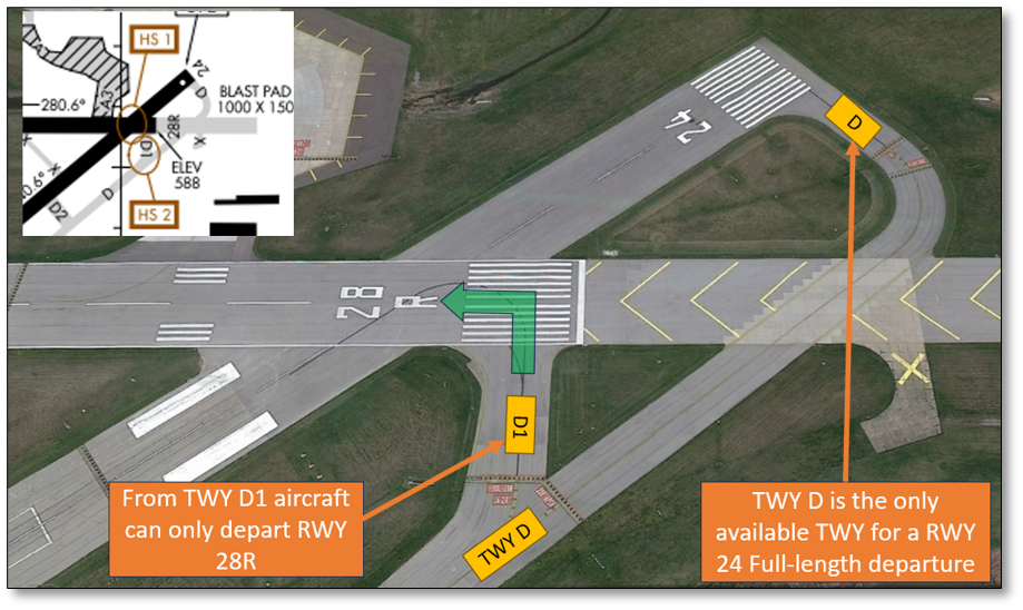
HS 1: RWY 28R departures from TWY D4 close proximity to RWY 24.
HS 2: TWY D goes full length RWY 24 departures. TWY D4 is for full length departures RWY 28R.
Wrong Surface Intersection Takeoff 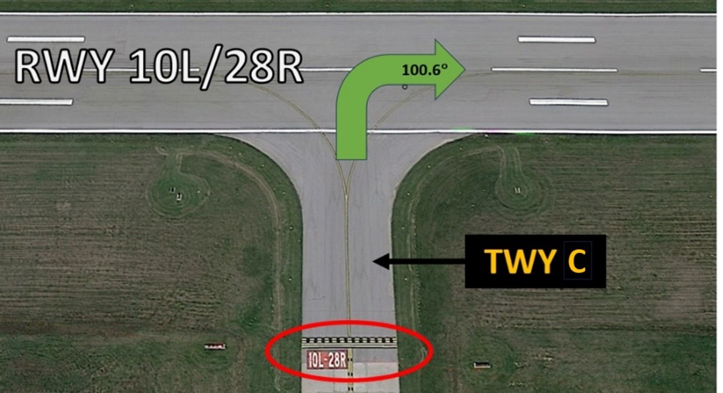
- Aircraft may be taxied for departure on RWY 10L at TWY C. Pilots are reminded to turn right onto RWY 10L for departure.
- There is the risk that pilots may turn in the wrong direction when taxiing onto a RWY for an intersection takeoff.
- At this intersection, the white numerical RWY Designators are not visible.
- Use the red RWY Holding Position markings/signs to identify the RWY.
- Check the Magnetic Compass and the Horizontal Situation Indicator (HSI), if installed, to verify that the aircraft is pointed in the correct direction.
- Intersection takeoffs on RWY 24 at TWY D1 are NOT AUTHORIZED.
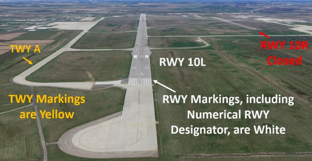
Wrong Surface TWY Landing
- Wherever a TWY runs parallel and full length next to a RWY, there is the risk that a pilot could mistakenly land on it. Use caution TWY D parallels RWY 6/24 and TWY A parallels RWY 10L/28R.
- Note: RWY markings are white. Also look for the white numerical RWY Designator.
- TWY markings are yellow.
Wrong Surface RWY Landing – Closed RWY
- RWY 10R/28L is permanently closed. Do not land on this closed surface.
Wrong Surface RWY Landing 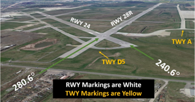
- Converging, Intersecting RWYs present the risk of landing on the wrong RWY.
- Back up all visual approaches with an instrument approach, if available.
- Always crosscheck the Magnetic Compass and Horizontal Situation Indicator (HSI), if installed, against RWY heading.
Surface Risk – Movement Area Cautions
- IAG has two hot spots that are in the northeastern section of the airport.
- Hot Spot 1 brings attention to the possibility of a wrong surface departure between RWY 28R and RWY 24.
- Hot Spot 2 highlights the possibility of taxiing to the wrong RWY.
- TWY D1 leads to the approach end of RWY 28R.
- TWY D leads to the approach end of RWY 24.
Additional Cautions
- TWY A is a non-movement area.
- TWY M is a non-movement area between the Private Flight Research ramp and TWY D.
- TWYs A, A1, A2, A3, A4, and M & L are non–mov areas and are not TWR controlled.
- Increased helicopter traffic from May to October departing from and arriving at the base of the control tower.
- Bird strike hazard - heavy concentrations of gulls, blackbirds, starlings up to 5000´ AGL on and in the vicinity of the airport.
- Extensive aircraft activity operating in vicinity of US/Canadian Falls all altitudes.
- RWY 28R Rollout end of RWY – last 900’ not grooved.
General
- Read back all hold short instructions with callsign.
- Please see the NE Chart Supplement Special Notices section for NIAGARA FALLS FLIGHT RESTRICTION AREA Part 93—Special Air Traffic Rules; Subpart E—Flight Restrictions in the Vicinity of Niagara Falls, New York.
Traffic Patterns
- Traffic patterns can be either left or right for all RWYs. Listen actively to the instructions of the TWR controllers.
- GA singles/twins 1400’ MSL, Tactical/Turbos 1600’ MSL. Military/AC 2100’ MSL.
Ground Control
- Advise ground control of current ATIS code when requesting taxi instructions.
- Use caution for hot spots in the vicinity of RWY 28R at TWY D4 and RWY 28R approach at TWY D5.
RWY 24 Full Length Departure 
- “What we typically do for RWY 24 departures is hold aircraft at the RWY 28R Approach Hold Short Line until that aircraft is ready. Then we have TWR taxi them across the RWY 28R Approach and confirm that they are holding short of RWY 24. We then get the IFR release or clear them for takeoff from there.
- We do understand that almost all aircraft cannot fit between these hold short lines on the inside of that turn and the tail of the aircraft will still extend over the RWY 28R Approach Hold Line.” (See Figure 8.)
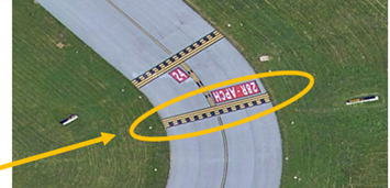
Figure 8
Takeoff/Departure
- Ensure that your heading matches the RWY that you were assigned.
- IAG does not utilize Line Up and Wait (LUAW) procedures. Expect takeoff clearance from the RWY Hold Short line.
Arrival/Landing
- When landing on RWY 28R, and your parking destination is south of the RWY, the last TWY that leads southbound is TWY C. Be aware that it is over 6000 feet from the RWY 28R approach end.
Weather
- Seasonal snow can be heavy and accumulate rapidly.
- If you see weather phenomena, report it. Our sensors pick up most things, but not everything.
- We appreciate your PIREPs.
Avoidance Areas
- CYR 518 is at the western edge of the class Delta airspace. This airspace is restricted to tour aircraft at or below 3000’. Aircraft wishing to view the Falls must be at or above 3500’ in right hand traffic and must communicate on 122.05 for pilot-to-pilot communications.
- See the NE Chart Supplement Special Notices section for NIAGARA FALLS FLIGHT RESTRICTION AREA Part 93—Special Air Traffic Rules; Subpart E—Flight Restrictions in the Vicinity of Niagara Falls, New York.
Special Traffic (Military / Commercial / Helicopter, etc.)
- Occasional commercial traffic.
- Most military traffic is heavy KC135R tankers stationed here at Niagara Falls. Additional military aircraft use the airport for pattern work and fuel stops.
- Due to heavy military jet traffic expect mandatory delays for wake turbulence.
- Tour helicopters operate May through October departing from and arriving at the base of the TWR.
- RWY 6/24 has military assault landing zone markings.
Clearance Delivery
- For VFR Flight Following (VFR Flight Advisories), provide:
- your call sign,
- type aircraft,
- destination,
- VFR altitude enroute
- Special requests.
- IFR aircraft that will fly into or through Canadian airspace after departure will be issued no higher than 6000’ for the initial climb.