
Robinson R44
Veracity Aviation, LLC, N474FA
Blanco, Texas
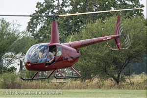
Photo copyright Jo Hunter - used with permission
October 11, 2012
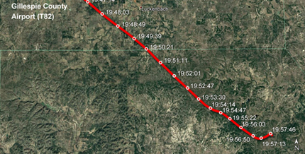
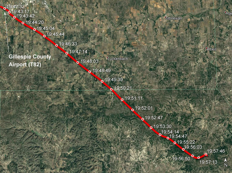
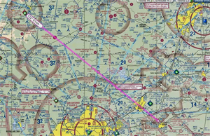
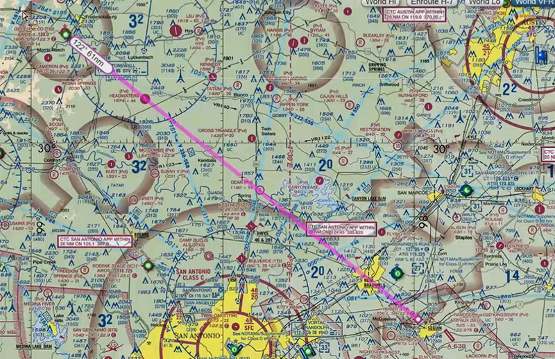
On October 11, 2012, at 1958 local time, a Robinson Helicopter Company model R44 II, N474FA, crashed during a night flight near Blanco, Texas. The aircraft took off from Gillespie County Airport (T82) in Fredericksburg, Texas and headed for Huber Airpark Civic Club LLC Airport (E70) in Seguin, Texas, which was an air distance of approximately 80 miles. The pilot and two passengers were fatally injured.
Meteorological data showed marginal visual flight rules (MVFR) conditions near the accident site at the time of the accident.
The National Transportation Safety Board (NTSB) determined the probable cause of this accident was the pilot's loss of helicopter control due to dark night conditions and spatial disorientation during MVFR.
NTSB Number: CEN13FA010

History of Flight
The helicopter was operated by Veracity Aviation LLC under the provisions of 14 Code of Federal Regulations (CFR) Part 91 without a flight plan. Night visual meteorological conditions prevailed for the flight that departed Gillespie County Airport (T82), Fredericksburg, Texas, about 1942 local time, and was en route to Huber Airpark Civic Club LLC Airport (E70), Seguin, Texas.
View Larger
View Larger
According to recovered GPS data, the roundtrip cross-country flight from the operator's home base at E70, located in Seguin, Texas, to Midland International Airport (MAF), in Midland, Texas, originally departed at 1241. The helicopter landed at MAF at 1503. The return flight departed MAF at 1735 and landed at T82 to refuel at 1936.
The aircraft, after refueling, departed Gillespie County Airport (T82), Fredericksburg, Texas, at 1942, and was en route to Huber Airpark Civic Club LLC Airport (E70), Seguin, Texas when the accident occurred.
View Robinson R44 Accident near Blanco Texas Animation below.
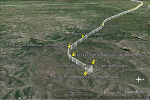
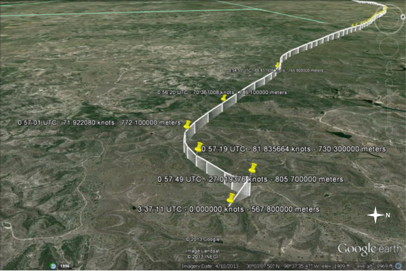
According to recovered GPS data, the flight departed T82 and proceeded on a southeast course towards the intended destination (E70). Two minutes prior to the accident, the helicopter entered a descending left turn from a southeast course to an east-northeast course. It then started a climb on a northeast heading. Prior to the climb, the helicopter was at 2,396 feet GPS altitude, about 500 feet above ground level, and the helicopter ground speed was 73 knots. The final data point was recorded at 19:57:49 with a GPS altitude of 2,634 feet, about 800 feet above the terrain, and a ground speed of 27 knots. The final data point was located about 0.2 miles north-northwest of the accident site.
| Minutes Before Last Data Point (Actual time) | Heading Direction | Ground Speed | GPS Altitude (Above Ground Level) in feet |
|---|---|---|---|
| Most of flight | South-East | 80 | Cruise (Alt not available in report) |
| 1 (19:56:50) | Descending left turn | 60 | 2517 (610) |
| 0.5 (19:57:19) | Starting climb northeast | 73 | 2396 (500) |
| 0 (19:57:49) | Crashed South-Southeast | 27 | 2643 (800) |
View Larger
The helicopter flight path is consistent with the NTSB determination that the pilot became spatially disoriented due to the lack of a discernible horizon while in dark night conditions and MVFR weather conditions.
At 2006, the USAF Rescue Coordination Center (AFRCC), located at Tyndall Air Force Base, Florida, received a 406 MHz emergency locator transmitter (ELT) signal assigned to the accident helicopter. About 18 minutes later, they received their first of several triangulated positions for the active ELT signal. With the assistance of airborne and ground units, first responders located the accident site at 0824 the next morning.
Wreckage and Impact Information
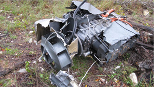
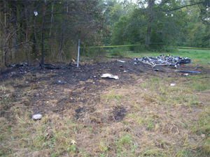
The helicopter wreckage was located near the summit of a hill in a sparsely populated area. A wreckage debris path originated from the initial point-of-impact on a south-southeast heading and consisted of fragmented airframe and flight control components. The main wreckage was about 160 feet from the initial point-of-impact. The engine, which had separated from the airframe, was located about 300 feet away.
A post-accident investigation confirmed that all airframe structural components were found at the accident site. There was no evidence of an inflight or post-impact fire.

View Larger
The NTSB concluded that there was no evidence of a pre-impact failure or malfunction of the helicopter structure, drive train, flight controls, hydraulic system, fuel system, and main and tail rotor systems that would have precluded normal operation. Structural fractures were consistent with overload forces encountered during the crash impact. Likewise, careful inspection of the separated engine found no evidence of pre-impact mechanical malfunctions or failures that would have precluded normal engine operation.
The aircraft was refueled before taking off on the accident flight. To rule out fuel contamination as a possible cause, investigators examined the fuel tanks. Both tanks had been damaged during impact and did not contain any recoverable fuel. They collected a fuel sample from the self-service fueling station used to fuel the accident helicopter before the accident flight. The sample was blue in color, consistent with 100 low-lead aviation fuel. Additionally, it did not contain any particulate or water contamination.
There were numerous separations within the fuel system and all were consistent with overstress fractures. The fuel selector valve was in the "ON" position.
Meteorological Information
View Larger
At 1900, a National Weather Service (NWS) surface analysis chart depicted a low pressure system over eastern Kansas with a cold front extending southwest through Kansas and into the Oklahoma panhandle. A warm front extended southeast from the low into eastern Oklahoma and Arkansas. A high pressure region was located over Alabama. The pressure gradient resulted in a general southeasterly wind flow that supported a warm moist air mass originating from the Gulf of Mexico.
At 2000, the NWS weather depiction chart showed a small area of marginal visual flight rules (MVFR) conditions near the accident site. The weather supported increasing low-level cloud development and scattered rain showers and thunderstorms.
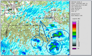
A review of weather radar data revealed that, between 1956 and 1958 local time, the helicopter's recorded GPS flight track bordered an area of light intensity echoes. Simultaneously, there was an area of light radar echoes that had developed immediately south of the accident site. The radar images revealed the potential of lower clouds and restricted visibility with light rain. Following the accident, several small areas of moderate-to-strong rain showers developed about two miles south of the accident site. These rain showers moved northward at 10 knots. No strong outflow winds or severe storm signatures were associated with the observed rain showers.
View Larger
The closest weather observing station was 22 miles northwest of the accident site, at the accident helicopter's departure point, Gillespie County Airport (T82). At 1955, the automated surface observing system reported wind 140 degrees magnetic at 5 knots, visibility 10 miles, scattered clouds at 1,900 feet above ground level, temperature 23 degrees Celsius, dew point 22 degrees Celsius, and an altimeter setting of 30.10 inches of mercury.
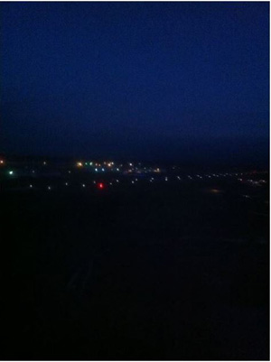
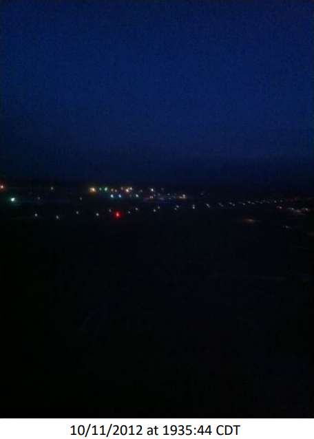
The adjacent picture looking southwest was retrieved from one of the passengers' cell phone. It was taken from the helicopter on the ramp, just prior to takeoff, and showed Runway 32 lights and lights from a golf course. This picture, taken three minutes after civil twilight, also showed it was already dark but the horizon was barely discernable. At the time of the accident, the moon was more than 15 degrees below the horizon and, as such, did not provide any illumination. Additionally, the accident site was located in a sparsely populated area with minimal illumination from ground light sources. As such, dark night conditions existed at the time of the accident.
The owner of the property where the accident occurred reported that it had been overcast a majority of the day with a noticeable lower cloud layer at the time of the accident. Driving east about 30 minutes prior to the accident, he observed a dark cloud with no lightning approximately four miles north of the accident site.
Personnel Information
According to FAA records, the pilot, age 35, held a commercial pilot certificate with helicopter and instrument helicopter ratings. He also held a flight instructor certificate with helicopter and instrument helicopter ratings. His second-class medical certificate without limitations was issued on March 31, 2011.
On March 15, 2012, the pilot received an Emergency Order of Revocation from the FAA informing him that his medical certificate had been revoked due to two offenses of driving while intoxicated (DWI).
| Date | Event | Medical Status |
|---|---|---|
| October 16, 2004 | 1st DWI Arrest | |
| March 31, 2011 | 2nd Class Medical | EXP 03/2013 |
| November 18, 2011 | 2nd DWI Arrest | |
| March 15, 2012 | Pilot receipt of letter from FAA Revoking Medical Certificate | Revoked |
| June 25, 2012 | Pilot response letter to FAA | Revoked |
| October 9, 2012 | FAA sent letter to pilot reiterating ineligibility to hold a medical certificate | Revoked |
| October 11, 2012 | Pilot killed in this crash | Revoked |
The owner of Veracity Aviation told the NTSB investigator that, although he knew of the pilot's November 2011 arrest, he was unaware that the FAA had revoked his medical certificate. Additionally, he was unaware that the pilot had been working with the FAA to reestablish his eligibility to hold a medical certificate. According to flight documentation provided by Veracity Aviation and the pilot's personal logbook, he had accumulated 218.1 hours as PIC and flight instructor since March 15, 2012, when he received the revocation order from the FAA.
The pilot's total flight experience was estimated to be about 1,527.3 hours, of which 543.7 hours were completed in the same make/model as the accident helicopter. The pilot was helicopter instrument rated with 55.4 hours. His logbook showed that he had received five hours of night instruction and had 70.7 hours of night flying and 300 night takeoff/landings as PIC. He had accumulated 1,464.5 hours as PIC and 644.4 hours as a flight instructor. He had accumulated 422.6 hours during the past year, 149.4 hours during the prior six months, 95.0 hours during previous 90 days, and 27.4 hours in the last 30 days. The pilot had flown 5.6 hours within the 24-hour period before the accident.
The pilot's employer, Veracity Aviation, provided flight instruction, local air tours, on-demand air taxi services, and external load operations. The accident pilot was employed as a flight instructor, assistant chief pilot for their 14 CFR Part 141 flight school, and as an external load PIC.
Due to the revocation of his medical certificate, the accident pilot was not authorized to act as PIC of any aircraft including as a PIC for Veracity Aviation's on-demand air taxi service under 14 CFR Part 135 at the time of this accident flight.
Aircraft Information
The accident aircraft was Robinson Helicopter Company model R44 II, serial number 12517. The helicopter was a four-seat, single-engine helicopter that was equipped with a skid type landing gear. The FAA type certificate required one flight crewmember (pilot) and permitted operations under day or night visual flight rules (VFR). Although the cockpit was equipped with flight attitude instrumentation and avionics, the accident helicopter was not certified for flight under instrument flight rules. The helicopter was powered by a de-rated 245-horsepower Lycoming model IO-540-AE1A5 reciprocating engine.
The helicopter was issued a Standard Airworthiness Certificate on October 14, 2008. A review of the maintenance records revealed that the helicopter had undergone an annual inspection on October 3, 2012 at 993.5 hours total time. At the time of the accident, the airframe and engine had accumulated 1,003.0 hours in service. The helicopter flew 9.5 hours since the last maintenance inspection. A review of maintenance documentation did not reveal any unresolved airworthiness issues.

View Larger
Weight and Balance
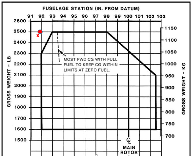
According to maintenance documentation, the NTSB determined the accident helicopter had a basic empty weight of 1,530.5 pounds, a center-of-gravity location of 106.9 inches, and a useful load of 969.5 pounds. The pilot weighed 200 pounds, the front seat passenger weighed 325 pounds, and the rear seat passenger weighed 200 pounds. According to the Robinson R44 II Pilot Operating Handbook, the seats were limited to 300 pounds. According to GPS flight data and refueling documentation obtained in the investigation, the accident helicopter had about 36 gallons (216 pounds) of fuel onboard when it departed. The additional personal property and cargo found onboard the helicopter weighed about 30 pounds. According to post-accident weight and balance calculations, the helicopter weighed about 2,501.5 pounds and had a center-of-gravity location of 91.85 inches when it took off. Investigators concluded from this analysis, that at the time of departure, the helicopter likely exceeded the maximum gross weight limitation of 2,500 pounds and had a center-of-gravity located forward of the allowable limit. Although not cited in the accident report as a causal factor, the Pilot Operating Handbook outlines that loading outside of these weight and balance limits can result in insufficient control travel for safe operations.
Medical and Pathological Information
An autopsy determined cause of death was attributed to multiple blunt-force injuries. Toxicological results were negative for carbon monoxide, cyanide, ethanol, and all drugs and medications.
Additional Data/Information
Night Operations (Chapter 13 of Helicopter Flying Handbook)
Spatial Disorientation
Spatial disorientation was cited by investigators as a contributor in this event. Spatial disorientation is a common factor in this type of accident, either as a primary accident cause or as a contributor to loss of control accidents.
The FAA Civil Aerospace Medical Institute (CAMI) has issued a publication explaining this phenomenon and its effect on pilots. This publication can be viewed at the following link:
Spatial Disorientation Publication
CAMI and EASA have also produced full-length videos on the subject of special disorientation and the dangers it can pose during instrument flight. The videos can be viewed at the following links:
Attitude Display Indicator
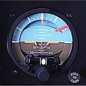
Photo used with permission - Robinson Helicopter
Pitch and attitude indicators, sometimes called attitude director indicators (ADIs), are a valuable instrument for any aircraft. The artificial horizon moves relative to a stationary representation of the aircraft at level flight. This allows a good approximation of what the attitude of the aircraft is outside the cockpit, especially when a stable visual reference outside the cockpit is not apparent or available. However, these instruments have limitations in which angles they can show. The FAA has published a SAFO on the topic of underperforming ADIs, SAFO17008, which states: "The range of indication according to TSO C4C in pitch shall be at least plus or minus 25°. The range of indication in bank shall be at least plus or minus 100°." These minimum performance requirements are not adequate for IFR certification of helicopters, but can provide enough information in the case of unintended flight in instrument meteorological conditions (UIMC). If the helicopter does exceed those given bank angles, the ADI will "peg out" and not give the pilot an accurate reading of bank and pitch angle. If continued flight into IMC occurs, it can lead to pilot spatial disorientation and potentially result in a crash. The SAFO also makes the recommendation for pilots to be aware of the performance and limitations of the instruments in their aircraft.
It is important to note that some Title 14 CFR part 27 certified aircraft, such as the accident aircraft, are not required to have ADIs because those aircraft are certified for VFR only and should not be operated in IFR conditions. In order to fly in IFR conditions, pilots must be rated to do so in an IFR-rated aircraft.
Conclusion
The pilot failed to adequately control the helicopter which was as a result of entering degraded Visual Meteorological Conditions (VMC), subsequently becoming spatially disoriented and crashing the helicopter. Additional factors that were discovered during the investigation that were contributing factors were the dark night conditions, over max gross weight and forward center of gravity conditions. Another factor included the performance and limitations of the ADI installed on the aircraft at the time of the accident. In addition, the accident aircraft was not certificated for IMC.
Additionally, investigators learned that the accident pilot did not report his disqualifying events for two DWIs; therefore disqualifying him from holding a valid medical certificate and prohibiting him to fly an aircraft.
The National Transportation Safety Board determined the probable cause of this accident to be:
The pilot's loss of helicopter control as a result of spatial disorientation due to dark night conditions and marginal visual flight rules weather conditions.
NTSB Number: CEN13FA010
§91.155 Basic VFR Weather Minimums.
Except as provided in paragraph (b) of this section and §91.157, no person may operate an aircraft under VFR when the flight visibility is less, or at a distance from clouds that is less, than that prescribed for the corresponding altitude and class of airspace in the table provided in the guidance.
Helicopter Flying Handbook FAA-H-8083-21A
Chapter 12 - Attitude Instrument Flying
Introduces basic instrument training. It is a building block toward basic instrument training, but it is not a substitute for the more detailed information found in the Instrument Flying Handbook FAA-H-8083-15
As stated in the handbook, "Prior to any flight, day or night, an inadvertent IMC plan should be carefully planned and, if possible, rehearsed. Many aircraft mishaps can be blamed on the pilot's inability to recover an aircraft after inadvertently entering IMC. The desire to stay outside visually is very strong and can only be overcome through training. IMC-trained helicopter pilots should climb to a safe altitude free of obstacles and obtain an instrument clearance from ATC. However, for the nonrated pilot and, more importantly, a non-IFR equipped helicopter, remaining VMC is critical. Pilots who are not trained in IMC have a tendency to try and chase favorable weather by flying just above the treetops or following roads. The thought process is that as long as they can see what is below them, then they can fly to their intended destination.
Experience shows us that continuing VFR flight in IMC is often fatal. Pilots get too fixated on what they see below them and fail to see what is ahead of them, such as power lines, towers, and taller trees. By the time the pilot sees the obstacle, it is too close to avoid collision. Helicopter pilots should always remain aware of flight visibility by comparing how much can be seen ahead. As soon as the pilot notices a marked decrease in visibility, that pilot must reevaluate the flight plan and landing options. A suitable landing area can always be used to sit out bad weather and let conditions improve.
When planning for a night flight, pilots should carefully plan the flight over navigable routes with sufficient check points to ensure clearance from obstructions. Descents should be planned over known and easily identifiable areas. Deteriorating weather is even harder to detect at night; therefore, pilots should constantly evaluate the weather throughout the flight. Below are some basic steps to help the pilot remain in VMC throughout the flight.
- Come to a hover if able or begin very slow flight just above translational lift speeds and land at the nearest safe area.
- Slowly turn around and proceed back to VMC weather or first safe landing area if the weather ahead becomes questionable.
- Do not proceed further on a course when the terrain ahead is not clearly discernable.
- Always have a safe landing area in mind for every flight and always be aware of the safe landing area's location.
- Study the route whenever possible before flying it and ensure to stay on course throughout the flight.
There are five basic steps that every pilot should be ultimately familiar with and should be executed immediately after inadvertently entering IMC.
- Attitude-level the wings on the attitude indicator, both pitch and bank.
- Heading-pick a heading that is known to be free of obstacles and maintain it. This may be 180° from your current heading.
- Power-adjust to a climb power setting.
- Airspeed-adjust to a climb airspeed.
- Trim-maintain coordinated flight so that an unusual attitude will not develop."
Also stated in the handbook, "The night flying environment and the techniques used when flying at night depend on outside conditions. Flying on a bright, clear, moonlit evening when the visibility is good, and the wind is calm is not much different from flying during the day. However, if flying on an overcast night over a sparsely populated area, with few or no outside lights on the ground, the situation is quite different. Visibility is restricted, so be more alert in steering clear of obstructions and low clouds. Options are also limited in the event of an emergency, as it is more difficult to find a place to land and determine wind direction and speed. At night, rely more heavily on the aircraft systems, such as lights, flight instruments, and navigation equipment. As a precaution, if visibility is limited or outside references are inadequate, strongly consider delaying the flight until conditions improve, unless proper instrument flight training has been received and the helicopter has the appropriate instrumentation and equipment."
Chapter 13 - Night Operations
Knowledge of the basic anatomy and physiology of the eye is helpful in the study of helicopter night operations. Adding to this the study of visual illusions gives the pilot ways to overcome those illusions. For example, Atmospheric Illusions - Rain on the windscreen can create the illusion of greater height, and atmospheric haze can create the illusion of being at a greater distance from an object. The pilot who does not recognize these illusions flies lower. Penetration of fog can create the illusion of pitching up. The pilot who does not recognize this illusion pushes the nose forward, often quite abruptly. Techniques for preflight, engine start-up, collision avoidance, and night approaches and landings help teach pilots safer ways to conduct flights at night.
While ceiling and visibility significantly affect safety in night VFR operations, lighting conditions also have a profound effect on safety. Even in conditions in which visibility and ceiling are determined to be VMC, the ability to discern unlit or low contrast objects and terrain at night may be compromised. An understanding of "seeing conditions" aides pilots as they gain night flying experience in a particular area. This knowledge helps them plan and accomplish flights in this area. If the normal area of operations changes the experience gained will help the pilot to identify hazards and determine acceptable levels of future risk.
The Pilots Handbook of Aeronautical Knowledge Chapter 16 pages 16-20 provides additional night operations information
Chapter 14 - Effective Aeronautical Decision-Making
Helicopters have the unique capability to fly and land in more diverse situations than fixed wing aircraft. Pilots attempting to fly the helicopter beyond their abilities or beyond the capabilities of the helicopter are many reasons for accidents. Instructors should incorporate single-pilot resource management (SRM) and risk management into flight training instruction of aeronautical decision-making (ADM).
SRM is the art of managing all resources, inside and outside of the aircraft before and during the flight. SRM is key component of ADM.
FAA-H-8083-15 Instrument Flying Handbook
Chapter 6 - Helicopter Attitude Instrument Flying
Controlling the aircraft by reference to the instruments rather than outside visual cues.
AC 60-4A "Pilot's Spatial Disorientation" Section 3(d)(e)4(a)(b)
As stated in the AC:
3. Discussion
3(d) "Surface references and the natural horizon may at times become obscured, although visibility may be above visual flight rule minimums. Lack of natural horizon or surface reference is common on overwater flights, at night, and especially at night in extremely sparsely populated areas, or in low visibility conditions. A sloping cloud formation, an obscured horizon, a dark scene spread with ground lights and stars, and certain geometric patterns of ground lights can provide inaccurate visual information for aligning the aircraft correctly with the actual horizon. The disoriented pilot may place the aircraft in a dangerous attitude. Other factors which contribute to disorientation are reflections from outside lights, sunlight shining through clouds, and reflected light from the anticollision rotating beacon."
3(e) "Another condition creating restrictions to both horizontal and vertical visibility is commonly called "white-out." "White-out" is generally caused by fog, haze, or falling snow blending with the snow-covered earth surface which may obscure all outside references. Therefore, the use of flight instruments is essential to maintain proper attitude when encountering any of the elements which may result in spatial disorientation."
4. RECOMMENDED ACTION
4(a) "You, the pilot, should understand the elements contributing to spatial disorientation so as to prevent loss of aircraft control if these conditions are inadvertently encountered."
4(b) "The following are certain basic steps which should assist materially in preventing spatial disorientation.
- Before you fly with less than 3 miles visibility, obtain training and maintain proficiency in aircraft control by reference to instruments.
- When flying at night or in reduced visibility, use your flight instruments, in conjunction with visual references.
- Maintain night currency if you intend to fly at night. Include cross-country and local operations at different airports.
- Study and become familiar with unique geographical conditions in areas in which you intend to operate.
- Check weather forecasts before departure, en route, and at destination. Be alert for weather deterioration.
- Do not attempt visual flight rule flight when there is a possibility of getting trapped in deteriorating weather.
- Rely on instrument indications unless the natural horizon or surface reference is clearly visible."
Night Flying
While the pilot was qualified to fly at night, the aircraft, while not rated for IFR operation, was equipped with basic ADI and HSI information. However, without a natural horizon the pilot was forced to fly with only the basic set of flight instruments, utilizing the turn and bank and pitot-static instruments to maintain control. This was a difficult task and as the accident report detailed, resulted in the pilot's disorientation and loss of control.
A Private Pilot- Rotorcraft has no regulatory requirement for training flight solely by reference to instruments (14 CFR 61.109c). Further there is no checking requirement under the current Practical Test Standard (PTS).
A Commercial Pilot-Rotorcraft requires five hours of training flight solely by reference to instruments (14CFR61.129c). There is no checking requirement under the current Practical Test Standard (PTS).
A Helicopter 135 competency check under 14CFR135.293c addresses a requirement for a pilot to be able to recover from UIMC/IIMC only if the helicopter is IFR certified. "For non-IFR-certified rotorcraft, the pilot must perform such maneuvers as are appropriate to the rotorcrafts installed equipment, the certificate holder's operations specifications, and the operating environment."
- Pilot operated the aircraft for hire without a valid medical certificate.
The Code of Federal Regulations requires that pilots remove themselves from flight duty due to any certificate revocation or disqualification. However, under 14 CFR Part 61.23 that requires pilots to hold a valid medical certificate, the accident pilot misrepresented his flight eligibility by flying an aircraft following revocation of his medical certificate. - The company permitted the pilot to use the aircraft.
Operators have the responsibility to initially establish and periodically review and confirm that their pilots are properly certified. As the helicopter was flown under 14 CFR Part 135, a company is responsible for adequately ensuring pilots are certified and qualified for flight. Companies have the opportunity to use various tools, such as the FAA website, the airmen registry, or similar means to determine pilot eligibility.
- The pilot continued flight in a degraded visual environment: flight into marginal VFR, dark night conditions, and minimal illumination from ground lights
- Aircraft was overweight and the center of gravity exceeded forward limits
- The pilot was flying without a valid medical certificate and was therefore prohibited from flying an aircraft
Visual meteorological conditions will exist for the entire flight
- The pilot became aware of degrading weather conditions but did not chose to "land and live"
A pilot maintains his qualification and currency in all applicable certificates for a flight
- The pilot did not hold a current medical certificate due to FAA revocation following two DWIs
In 2016, the USHST adopted a goal of a 20% reduction in the U.S. fatal helicopter accident rate by 2020 to 0.61 per 100,000 flight hours. The USHST is a volunteer organization comprised of U.S. government and industry professionals. The USHST is governed by a steering committee, co-chaired by government and industry representatives.
As part of an effort to achieve this goal, the USHST adopted a process derived from efforts undertaken in commercial aviation and fixed-wing general aviation. The purpose is to develop and prioritize data-driven risk mitigations more closely aligned with the processes of two other key public-private safety groups; the Commercial Aviation Safety Team (CAST) and the General Aviation Joint Steering Committee (GAJSC).
On October 3, 2017, the USHST published a report which explains the development and content of the USHST's first risk mitigations under this process, called Helicopter Safety Enhancements (H-SEs).
SAFO 17008, 25 May 2017 Attitude Indicator Pitch Limitations
Purpose: This SAFO serves to notify aircraft operators of potential operational limitations of some attitude indicators in the event of unusual attitude recovery as recommended by National Transportation Safety Board (NTSB) Safety Recommendation A-14-108.
View SAFO 17008
Rotorcraft Life Cycle:
- Operational
Accident Threats:
- Controlled Flight Into or Toward Terrain (CFIT)
- Unintended Flight in IMC (UIMC)
Industries:
- Commercial
Accident Common Themes:
- Organizational Lapses
- Human Error
Human Error
The accident pilot continued flight in deteriorating weather conditions resulting in spatial disorientation and loss of control.
The pilot failed to remove himself from flight duty when he no longer held a valid medical certificate.
Organizational Lapses
The operator did not ensure that the accident pilot was properly certified.
Flawed Assumptions
An instrument-rated pilot can operate in IFR conditions in a helicopter that is only certificated for VFR flight.
NTSB Identification: CEN10FA509
14 CFR Part 91: General Aviation
Accident occurred Tuesday, August 31, 2010 in Walnut Grove, AR
Probable Cause Approval Date: 11/17/2011
Aircraft: BELL HELICOPTER TEXTRON 206L-1, registration: N62AE
Injuries: 3 Fatal
The air ambulance positioning flight was en route to a landing zone to pick up a patient for transfer. One witness in the accident area described a helicopter circling overhead, and another witness reported that they heard the sound of crashing metal or the impact of the helicopter with the ground.
Radar and global positioning system data depicted the accident helicopter reversing course multiple times just prior to the accident. The flight path of the helicopter prior to the accident was consistent with spatial disorientation and subsequent loss of control due to an inadvertent encounter with instrument meteorological conditions.
NTSB Identification: WPR13FA080
14 CFR Part 91: General Aviation
Accident occurred Wednesday, January 02, 2013 in Delano, CA
Probable Cause Approval Date: 03/07/2014
Aircraft: BELL 206, registration: N828AC
Injuries: 1 Fatal
NTSB investigators either traveled in support of this investigation or conducted a significant amount of investigative work without any travel, and used data obtained from various sources to prepare this aircraft accident report.
The accident helicopter was returning to the airport. Dark night visual meteorological conditions prevailed at the time with increasing fog. The pilot of a second helicopter, who was flying nearby and was in contact with the accident pilot, stated that, before the accident, he saw the accident helicopter make a right turn; he then asked the pilot if she was lost. The accident pilot responded that she thought she was. The second pilot told her to turn left toward the airport. Shortly after, the second pilot observed a fire on the ground and attempted to contact the accident pilot but received no reply. The accident helicopter crashed about 10 miles southeast of the destination airport. Post-accident documentation of the accident site revealed signatures indicative of a steep right turn while impacting vegetation and terrain. Examinations of the helicopter and engine revealed no evidence of preimpact mechanical malfunctions or failures that would have precluded normal operation. The dark night conditions, sparsely lit terrain, and accumulating fog reduced the visual cues available for the pilot to maintain orientation, and, under those conditions, the helicopter's external spotlights, which were on during the accident flight, could have further reduced or provided misleading visual cues. These conditions were conducive to the development of spatial disorientation.
The NTSB determined the probable cause of this accident as follows was the pilot's failure to maintain helicopter control due to spatial disorientation while maneuvering in low visibility, dark night conditions.
NTSB Identification: ERA13FA273
14 CFR Part 91: General Aviation
Accident occurred Thursday, June 06, 2013 in Manchester, KY
Probable Cause Approval Date: 09/24/2014
Aircraft: BELL HELICOPTER TEXTRON 206L-1, registration: N114AE
Injuries: 3 Fatal
NTSB investigators either traveled in support of this investigation or conducted a significant amount of investigative work without any travel, and used data obtained from various sources to prepare this aircraft accident report.
The air ambulance repositioning flight was en route to base following a patient transfer. Weather information forecast about three hours before the accident indicated a moist environment; however, visual conditions were anticipated around the time of the accident. An updated forecast was published about ten minutes before the accident, and it indicated that fog or low stratus cloud development was possible and that visibility could decrease to near or below airport weather minimums in the early morning hours. Witness statements and the reported weather conditions indicated that patchy fog had developed near the helipad at the time of the accident and that visibility at the accident site was 1/4 mile; however, the specific visibility conditions encountered by the helicopter during its approach could not be determined. A witness reported seeing the helicopter "flying lower than normal" and then spinning before impact. Another witness reported seeing the helicopter in a nose-down attitude and then impact the ground.
The wreckage was located in a school parking lot, which was about 750 feet from the landing pad and at an elevation of about 900 feet mean sea level (MSL). The wreckage distribution was consistent with an in-flight separation of the main rotor and tail boom. An examination of the helicopter airframe, engine, and related systems revealed no pre-impact anomalies that would have precluded normal operation. Both the main rotor assembly and tail boom separated in overload.
Review of GPS data showed the accident helicopter descending in three right circuits near the landing pad just before the accident. The final recorded data were in the immediate vicinity of the accident location and indicated an altitude of 1,437 feet MSL. The maneuvering flightpath of the helicopter before the accident was consistent with an attempt to avoid fog followed by a loss of control. Although the pilot was instrument rated, he had not logged recent instrument time. Further, although the pilot had recent training in night vision goggle usage and had night vision goggles available during the flight, it could not be determined if he was using them at the time of the accident. Given the reports of fog in the area and the accident circumstances, it is likely that the pilot entered instrument meteorological conditions during the approach to the helipad, which resulted in spatial disorientation and loss of control.
The NTSB determined the probable cause of this accident the pilot's loss of helicopter control due to spatial disorientation when he inadvertently encountered night, instrument meteorological conditions, which resulted in the in-flight separation of the main rotor and tail boom.
Technical Related Lessons
Flight using visual flight rules (VFR) requires a continuous awareness of the horizon. Pilot loss of an external horizon reference, for even a few seconds, can often result in sensory illusions and correspondingly incorrect control inputs. This can rapidly lead to aircraft attitudes from which recovery is difficult or impossible. (Threat Category: UIMC)
- The flight was based on weather forecasts that indicated conditions conducive to VFR flight. Yet, weather conditions deteriorated prior to the flight and associated weather briefings to the pilot did not present a complete picture of the actual conditions. In addition, the flight took place at night in a sparsely populated area. Investigators determined that these dark night conditions were conducive to visual illusions such as auto-kinesis, vertigo (due to flickering lights, including anti-collision lights) and false horizon, which led to the pilot's loss of situational awareness and loss of control of the helicopter.
Common Theme Related Lessons
The regulations for medical certification initial issuance, renewal, and continued eligibility are reliant upon pilot honesty and integrity. The Code of Federal Regulations requires that pilots remove themselves from flight duty due to any certificate revocation or disqualification. Operators have the responsibility to initially establish and periodically review that their pilots are properly certified. (Common Theme: Organizational Lapses)
- Investigators concluded that the pilot misrepresented his flight eligibility status during the period his medical certificate was revoked. He ignored formal requests from the FAA to surrender his medical certificate, and therefore flew illegally as a commercial pilot.
- Misrepresentation and failure to disclose disqualification by pilots is against Federal Aviation Regulations (CFR) and is subject to fines and suspension of the airmen certificate.
- Tools such as the FAA website, the airmen registry, or similar means are available to operators to determine pilot eligibility.
The human body has limitations and is subject to misleading or lack of visual references, potentially leading to the rapid onset of spatial disorientation. Pilots should always be aware of their surroundings and limits and practice good decision-making. (Common Theme: Human Error)
- Even if pilots are instrument rated, they need to be aware of environmental conditions in VFR flight, such as dark night, visual illusions, and masked terrain, which may lead to spatial disorientation. In a degraded visual environment, pilots should rely on their instruments to fly the aircraft; however, helicopter pilots should strive to observe the USHST's "land and live" initiative. In this accident, it was determined that although the pilot had been previously instrument rated, he was unsuccessful in transitioning from VFR into UIMC.
- Spatial disorientation was cited as a contributor in this event. Investigators concluded that lack of a discernable horizon led to a further loss of visual reference, resulting in spatial disorientation.
- The FAA Civil Aerospace Medical Institute (CAMI) has issued a publication explaining this phenomenon and its effect on pilots. This publication can be viewed at the following link: Spatial Disorientation Publication